Des Moines International Airport Map (Most Up-To-Date)
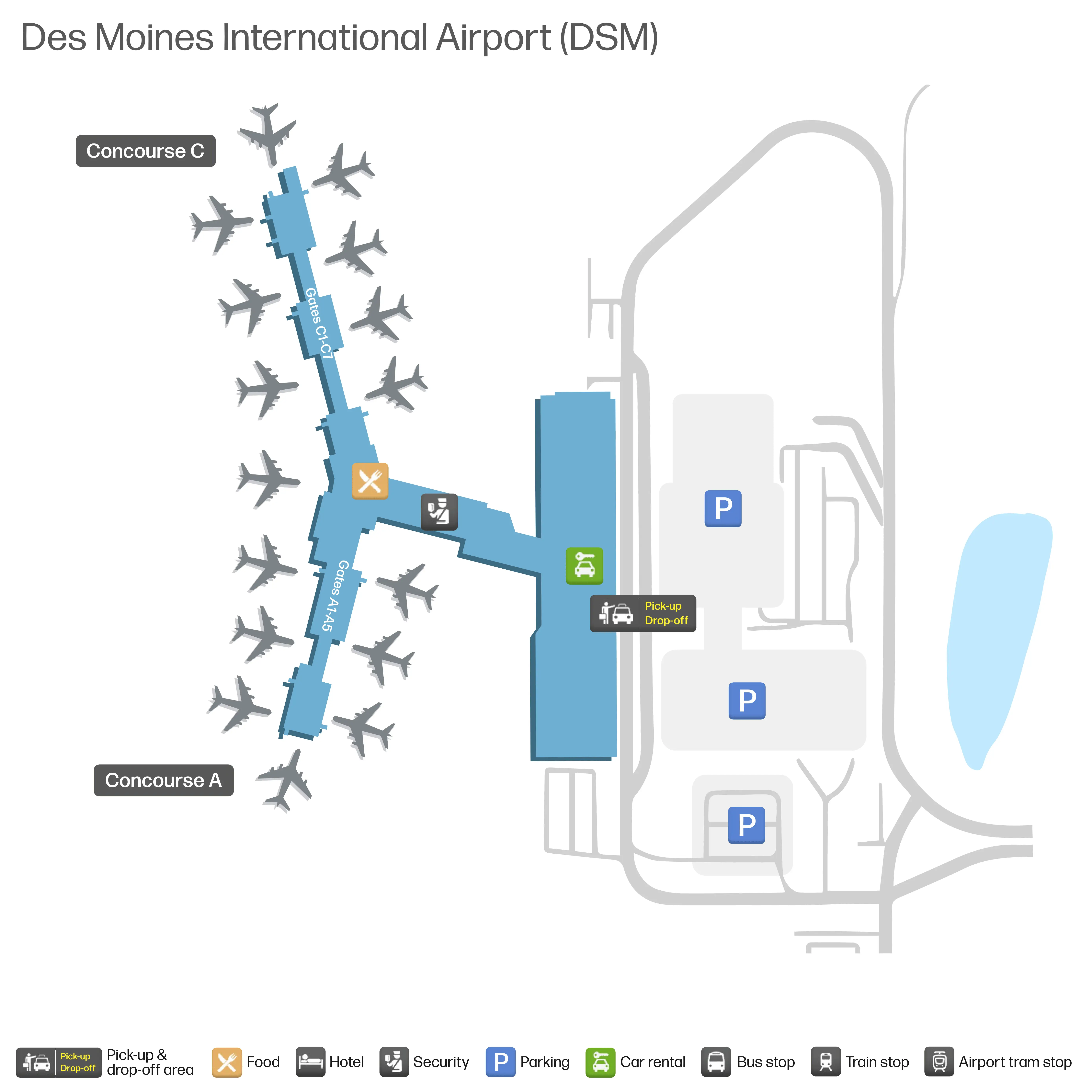
Des Moines International Airport is a compact, single-terminal “Y-split” layout: one central ticketing atrium feeds one TSA funnel, then splits airside into Concourse A (shorter) and Concourse C (longer). The whole footprint is small, but chokepoints amplify fast because there’s no parallel path. During Lift DSM Phase 1A, the garage-based EZ Pickup and the single checkpoint geometry behave like the airport’s “control knobs” within Iowa’s main air hub.
Map Table
| Terminal | Key Airlines | Primary Function | Transfer Mode |
|---|---|---|---|
| Main Terminal (Ticketing Atrium) | American, Delta, United | Check-in, TSA access | Walk |
| Concourse A | Allegiant, Southwest, United | Gates A1–A5 | Walk |
| Concourse C | American, Delta, Frontier | Gates C1–C7 | Walk |
| Parking Garage (EZ Pickup) | Ride App, Private pickup | Staging, pickup | Skywalk + elevator |
Des Moines International Airport Map Strategy
- Treat Des Moines International Airport as a single-thread system: check-in, TSA, curb, and shuttles each have one primary path, so pick your path early and commit.
- Neutralize the TSA funnel by finding where the stanchions actually begin in the atrium, not where the checkpoint doors are.
- Default pickups to EZ Pickup inside the garage using stall numbers; skip curb coordination unless the passenger is already standing outside.
- For remote/economy lots, plan around shuttle cadence uncertainty: park by the most central stop and assume detours via Leland Avenue during construction.
2026 Des Moines International Airport Map + Printable PDF
Lift DSM construction phasing remains the main driver of “my map is wrong” stress at 2026 Des Moines International Airport: curbside behavior is enforced as active-loading-only, pickups are pushed into the garage EZ Pickup model, and the centralized TSA queue can spill into the atrium. A printable 2026 map is most useful when it marks the real queue start, the Skywalk-to-garage path, and the Cowles Drive circulation constraints.
2026 Des Moines International Airport Map Guide
What is the exact walking distance (in feet/meters) from the American Airlines ticket counters to the main TSA checkpoint entrance?
The walk is approximately 180 feet (55 meters) from the American Airlines ticket counters to the main TSA checkpoint entrance. This is a short, direct pre-security transfer across the central ticketing atrium, but it can feel longer when American’s queue spills into the main circulation lane between the American and United/Delta counter areas.
The most reliable path is the straight-line crossing from the American counter frontage toward the central atrium checkpoint, aiming for the TSA document-check podium area. If the American line is perpendicular to the walkway, cut around the outside edge of the crowd rather than trying to thread through the middle, since the compression here is what turns “short distance” into “high-friction feet.”
Where is the physical start point of the TSA serpentine queue (the spot you actually join the line) relative to the checkpoint doors?
The TSA serpentine queue starts in the center of the main atrium about 40–60 feet (12–18 meters) before the checkpoint’s document-check podiums, not at the checkpoint doors. The join point is typically the first stanchion opening (“Enter Here”) set into the open floor area between the escalators and the ticket-counter bulkheads.
Because the line is designed to expand outward into the atrium, the correct move is to walk past the checkpoint doors visually and look for the stanchion farm in the middle of the hall. If you enter the atrium facing the checkpoint, the queue start is usually offset toward the open center space rather than tight to the wall at the podiums, so you’ll join from the atrium side, not from the door line.
What is the exact walking distance from the short-term parking garage elevators to the EZ Pickup numbered stalls area?
The walk is 0–100 feet (0–30 meters) from the short-term parking garage elevator core to the EZ Pickup numbered stalls. The EZ Pickup stalls are positioned as “prime real estate” in the hourly garage, clustered immediately adjacent to the elevator/skywalk vestibule so drivers and passengers can connect with minimal walking.
Because allocation can shift with Lift DSM phasing, use the overhead garage signs to confirm the active EZ Pickup zone (for example, a lettered zone or numbered stall cluster) as soon as you step out of the elevator. If you can see the skywalk entrance doors from the elevator lobby, you’re already in the correct proximity band; the stalls should be within the same bay or the next bay over.
Where is the EZ Pickup vehicle exit route onto the main airport road (which specific ramp/turn leads you out)?
The EZ Pickup exit route is the garage toll-plaza exit that feeds directly into Cowles Drive southbound. After leaving the numbered-stall area, drivers descend the garage helix to the toll/exit lanes, validate the ticket, then follow the outbound lane that merges into the Cowles Drive loop heading toward the airport exit and Fleur Drive.
This merge happens immediately after the toll plaza and is the key “commit point”: the geometry shoots you out past the arrivals-curb stream, so you should not expect a quick right turn back into curb pickup. Keep the ticket accessible to avoid stopping at the gate, because a stalled vehicle at the boom barrier backs up the entire exit lane and increases the merge stress right where garage traffic meets the curbside flow.
What is the exact walking distance from the economy/remote lot shuttle drop-off point to the ticketing hall entrance doors?
The walk is approximately 30–50 feet (9–15 meters) from the economy/remote lot shuttle drop-off point to the ticketing hall entrance doors. The shuttle drop typically aligns with the ticketing-level curb/center-island area closest to the main automatic door vestibules between the American and United ticketing zones.
After stepping off the shuttle, cross a single traffic lane at the marked crosswalk to reach the automatic sliding doors. Because the drop point can shift slightly with daily construction barricades, the fastest cue is the door cluster under the largest ticketing canopy and the highest pedestrian flow; if you see the American and United counter banks in front of you after entering, you used the correct vestibule.
Where are the remote parking shuttle stop locations physically positioned within each lot (stop-by-stop placement)?
The remote parking shuttle stops are placed as named, fixed pickup points along each lot’s main internal drive, with each stop serving a specific segment of rows. In the Grey Lot, the stops are arranged in a linear sequence (South, Central, North) so the shuttle can sweep the lot end-to-end; in the Blue Lot, two stops (South, North) split the footprint; in the Red Lot, two stops (East, West) serve opposite sides of the lot.
- Grey Lot: South stop, Central stop, North stop along the primary drive aisle
- Blue Lot: South stop and North stop on the main loop aisle
- Red Lot: East stop and West stop on the lot’s central access aisle near Fleur Drive side access points
What is the exact walking distance from the TSA exit to the farthest active gate in the concourse?
The walk is approximately 850 feet (260 meters) from the TSA exit to the farthest active gate, Gate C7. This is the longest straight-line airside walk at Des Moines International Airport because Concourse C is the longer pier.
From the TSA recomposure area, walk about 50 feet to the post-security “Y” split, then turn right into Concourse C and continue straight past Gates C1 through C6 to reach C7 at the end of the corridor. In light crowds this is a 3.5–4 minute walk, but the narrow hallway can slow down when boarding groups cluster near the gate podiums, reducing the effective walking width.
Where is the fastest indoor route from baggage claim to the parking garage (EZ Pickup level) entrance?
The fastest indoor route runs through the enclosed skywalk on Level 2. From baggage claim on Level 1, take the nearest elevator or escalator up to Level 2, follow signs for the skywalk/parking garage connection, cross the enclosed bridge, then enter the garage and use the garage elevator or stairs to reach the active EZ Pickup level.
This “golden path” works because it avoids the curbside squeeze point outside the baggage doors and eliminates the weather-and-construction friction of walking at roadway level. The key landmark is the interior vertical core near baggage claim; once you’re on Level 2, the skywalk is the controlled, uninterrupted link straight into the garage access vestibule.
What is the exact walking distance from the baggage claim carousel area to the standard passenger pickup curb (non–EZ Pickup)?
The walk is approximately 40–60 feet (12–18 meters) from the baggage claim carousel area to the standard passenger pickup curb. The curb is immediately outside the baggage claim automatic sliding doors on the ground level.
The shortest line is carousel edge → sliding doors → curb lane. The operational catch is that this curb is enforced as active loading only, so the distance is short but the timing tolerance is near-zero. If the vehicle arrives before the passenger is physically at the curb, the driver is typically forced into the Cowles Drive recirculation loop, adding several minutes and increasing pickup confusion.
Where is the rideshare pickup zone located relative to the main terminal exit doors (which door set + what direction)?
The rideshare pickup zone is in the parking garage, not at the terminal curb, and it is reached by walking from the terminal toward the garage connection. After exiting the main terminal doors, follow the “Ride App”/TNC signage toward the garage access, using the skywalk connection when available (or the signed crosswalk routing when the skywalk approach is routed differently by construction).
The key positional rule is directional: instead of turning into the curb lanes outside the exit doors, you turn away from the curbside stream and move into the garage structure. If you can see the skywalk/garage entry vestibule signage from the exit area, you are on the correct path; the rideshare zone is staged inside the garage in a dedicated Ride App pickup area.
What is the exact walking distance from the nearest restrooms post-security to the closest gate cluster?
The walk is approximately 50 feet (15 meters) from the nearest post-security restrooms to the closest gate cluster. The restroom blocks sit at the “throat” where the TSA exit feeds into the concourse split, immediately beside the first gates at the start of each pier.
After clearing TSA and entering the recomposure zone, the restrooms are adjacent to the concourse entrances near Gates A1 and C1. Use the restrooms here if you’re headed to the far end of Concourse C (toward C7), since walking back later can turn into a longer round trip once boarding crowds narrow the corridor.
Where is the closest alternate pickup location to baggage claim that avoids the main curb chokepoint (exact zone/level/side)?
The closest alternate pickup location is the EZ Pickup area inside the parking garage, accessed via the Level 2 skywalk. DSM does not have a true secondary arrivals curb on a separate level, so the garage staging system is the only sanctioned way to avoid the baggage-claim curb chokepoint.
From baggage claim (Level 1), go to the interior elevator/escalator, ride up to Level 2, cross the enclosed skywalk, then enter the garage and navigate to the numbered EZ Pickup stalls. The location anchor is the skywalk bridge connection; once you are on Level 2, follow the garage signage to the active stall range rather than exiting to the curb.