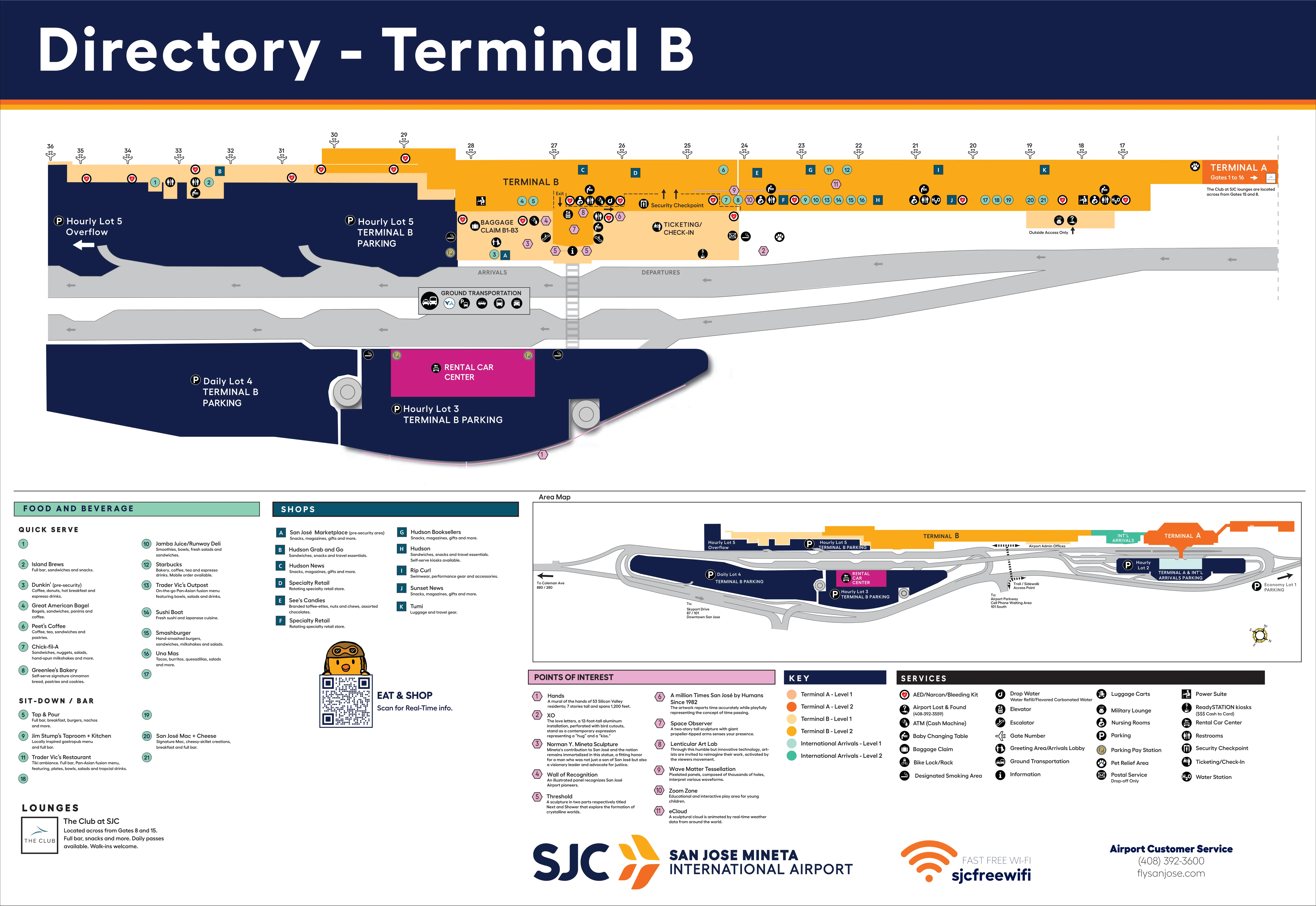
San Jose International Airport Terminal B Map (Most Up-To-Date)
Terminal B at San José’s main airport complex is a long, linear concourse that runs roughly north–south, with the security exit feeding into a central concessions “hub” and gates stretching far south into the newer annex (Gates 31–36). The layout rewards straight-line walking but punishes small wrong turns at peak times, especially around the Level 1–to–Level 2 vertical core and the arrivals curb/rideshare island across the roadway.
Map Table
| Zone | Connection | Walk Time |
|---|---|---|
| Level 1 Ticketing | central escalator/elevator core | 2–4 min to TSA (shortest path) |
| Level 2 Checkpoint Exit | main concourse hub near Gate 24 corridor | 1.5–2.5 min to Gates 24–28 |
| South Annex | main corridor past Gate 28/30 | 6–12 min to Gate 36 |
| Arrivals / Baggage Claim | Door 24–26 to Ground Transportation Island | 2–5 min to Stops 7–10 (crosswalk-dependent) |
San Jose Mineta International Airport Terminal B Map Strategy
- Treat the Level 1 escalator base as the go/no-go checkpoint: if the queue is static at the vertical core, bail before you ascend and flank north to Terminal A security (carry-on only), then return airside via the connector.
- Calibrate gate risk by number: Gates 24–28 are “near-core,” while Gate 36 is an annex march—build a 15-minute buffer if you see Gate 35/36 on the boarding pass.
- Use the connector deliberately: Terminal A airside connector entry near Gates 15–16 (by The Club at SJC), Terminal B exit near Gate 17/International block; plan the extra walk from Gate 17 up to the 24–28 cluster.
- Arrivals pickups follow the island protocol: exit baggage claim near Door 26 for Stops 8–10, cross at the marked crosswalk to the Ground Transportation Island, then orient by stop (7 Waymo, 8–9 Uber, 10 Lyft) to avoid curbside coordination failures.
2026 San Jose International Airport Terminal B Map + Printable PDF
Terminal B’s operational reality in 2026 still hinges on “compression” points: the Level 1 bag-drop frontage feeding a tight vertical core, a security recomposure area that can back up to the escalator base, and an arrivals pickup layout that splits private pickup (inner curb) from app-based rideshare (island stops). A printable 2026 map is most useful when it highlights decision nodes, not just gate numbers.
2026 San Jose International Airport Terminal B Guide
What is the exact walking distance (in feet/meters) from Terminal B Security Checkpoint exit to the Southwest gate cluster (Gates 24–28)?
Walking distance is about 280 ft (85 m) to Gate 24 and about 450 ft (137 m) to Gate 28 from the Terminal B security checkpoint exit. Those numbers bracket the Southwest Gates 24–28 cluster because the gates line up along the same southbound corridor immediately after you clear security.
| Route point | Approx. distance |
|---|---|
| Checkpoint exit → Gate 24 | ~280 ft / ~85 m |
| Checkpoint exit → Gate 28 | ~450 ft / ~137 m |
What is the exact walking distance from Terminal B Security Checkpoint exit to the furthest Terminal B gate (Gate 36) along the main corridor?
Walking distance is about 1,450–1,600 ft (440–490 m) from the Terminal B security checkpoint exit to Gate 36. The walk stays on the straight southbound concourse, continuing past the Gates 24–28 zone, through the architectural transition into the South Annex, and down to the southern terminus where Gate 36 sits.
| Segment | Approx. distance |
|---|---|
| Checkpoint exit → Gate 36 (terminus) | ~1,450–1,600 ft / ~440–490 m |
Where is the fastest post-security walking route from Terminal A checkpoint exit to Terminal B Gates 24–28 (name the corridor/connector and endpoints)?
The fastest post-security route is the airside connector corridor between Terminals A and B, exiting into Terminal B near Gate 17 and continuing south to Gates 24–28. After Terminal A security, walk south past Gates 12–15 to the connector entrance by Gates 15–16 (near The Club at SJC), take the long connector corridor (with moving walkways), then emerge in Terminal B by Gate 17 and continue south past Gates 18–23 to the 24–28 cluster.
| Step | Route landmark endpoints |
|---|---|
| 1 | Terminal A checkpoint exit → southbound concourse past Gates 12–15 |
| 2 | Connector entry between Gates 15–16 (near The Club at SJC) |
| 3 | Airside connector corridor → Terminal B exit by Gate 17 |
| 4 | Gate 17 → south past Gates 18–23 → Gates 24–28 |
Where is the airside connector hallway between Terminal A and Terminal B located (identify the nearest gate number(s) on each side)?
The airside connector hallway is located between Gates 15 and 16 on the Terminal A side and adjacent to Gate 17 on the Terminal B side. On Terminal A, it’s near The Club at SJC; on Terminal B, it emerges at the north end by the international arrivals block, with the pet relief area commonly referenced as being between Gates 16 and 17 inside the secure area.
| Terminal side | Nearest gates |
|---|---|
| Terminal A | between Gates 15–16 |
| Terminal B | adjacent to Gate 17 |
What is the exact walking distance from Terminal B bag drop / ticketing frontage to the Terminal B security checkpoint entrance (shortest path)?
Walking distance is about 150 ft (45 m) plus the vertical rise from Level 1 ticketing to Level 2 security. The shortest path runs from the main check-in counter line (Southwest/Alaska central zone) to the central escalator/elevator core, up one level, then directly to the TSA document-check podiums, which sit within roughly 20 ft of the escalator landing.
| Route point | Approx. distance |
|---|---|
| Ticketing/bag drop → base of escalators | ~50–75 ft / ~15–23 m |
| Level change (Level 1 → Level 2) | ~25 ft elevation / ~7.6 m rise |
| Escalator landing → TSA entry/podiums | ~20 ft / ~6 m |
| Total shortest path | ~150 ft / ~45 m + vertical |
Where is the last practical decision node (on foot) to switch from the Terminal B checkpoint plan to the Terminal A checkpoint plan before you commit to one line (identify the landmark/intersection)?
The last practical decision node is on Terminal B Level 1 at the central vertical circulation core, before you step onto the escalators to Level 2 security. Stand near the central information area and the “Shifting Time” artwork, look at the escalator base, and decide: if the queue is static or spilling into Level 1, turn back to the curbside doors around Door 20/21, exit to the sidewalk, and walk north to Terminal A.
| Decision point | Adjacent landmark |
|---|---|
| Level 1, base of Terminal B escalators (before ascending) | “Shifting Time” artwork / central information area |
| Exit point to execute the switch | curbside sliding doors near Door 20/21 |
What is the exact location of Terminal B app-based rideshare pickup stalls (stall numbers + curb segment) relative to the Terminal B baggage claim exit doors?
Rideshare pickup at Terminal B uses stop zones (not individual stall numbers) on the Ground Transportation Island directly across the roadway from the baggage claim exits. The app-based stops are labeled Stop 7–Stop 10: Stop 7 (Waymo), Stops 8–9 (Uber/Tesla), and Stop 10 (Lyft/Wingz). Relative to baggage claim, Door 26 lines up best for Stops 8–10; Door 24 is better aligned for Stop 7.
| From baggage claim | Where to stand outside |
|---|---|
| Exit Door 26 | cross to Ground Transportation Island, then southbound curb for Stops 8–10 |
| Exit Door 24 | cross to Ground Transportation Island, then northbound curb for Stop 7 |
| Geometry note | island curb across roadway; inner curb at building is private pickup |
What is the shortest walking route from Terminal B baggage claim to the designated rideshare pickup zone (list the sequence of turns/doors by map labels)?
The shortest route is Door 26 to the marked crosswalk to the Ground Transportation Island, then a short turn to your stop zone. From baggage claim, position yourself near the central carousels, exit via Door 26, and you’ll land closest to the island stops used for Uber/Lyft. After crossing, turn right (south) for Stops 8–10, or turn left (north) for Stop 7.
| Step | On-foot sequence |
|---|---|
| 1 | Baggage claim carousel area → Door 26 |
| 2 | Exit to inner curb (building-side sidewalk) |
| 3 | Walk to marked crosswalk → cross to Ground Transportation Island |
| 4 | Turn right (south) for Stops 8–10; turn left (north) for Stop 7 |
How many active curbside pickup vehicle lengths exist at Terminal B arrivals (count marked curb segments) from the first to last legal pickup point?
Active curbside capacity is about 12–15 vehicle lengths on the Terminal B inner curb for private pickup, plus about 8–10 vehicle lengths on the Ground Transportation Island for app-based rideshare stops. The inner curb is the building-side “active loading only” zone; the island curb is the dedicated rideshare zone (Stops 7–10) across the roadway.
| Pickup area | Estimated active vehicle lengths |
|---|---|
| Private pickup (inner curb at building) | ~12–15 |
| App-based rideshare (Ground Transportation Island) | ~8–10 |
| Combined constrained frontage | ~20–25 |
What is the exact walking distance from Terminal B baggage claim to the Rental Car Center access point shown on the airport map (shortest signed path)?
Walking distance is about 350–500 ft (100–150 m) from Terminal B baggage claim to the Rental Car Center access point, using the signed crosswalk route. Exit baggage claim to the inner curb, cross to the Ground Transportation Island, then cross Airport Boulevard at the signalized crosswalk into the Rental Car Center lobby directly opposite Terminal B.
| Route point | Approx. distance |
|---|---|
| Baggage claim exits → RCC lobby (shortest signed walk) | ~350–500 ft / ~100–150 m |
Where is the nearest overflow waiting area (benches/seating) in landside Terminal B that does not block the primary pickup flow (identify on-map location near baggage claim/arrivals)?
The nearest practical overflow seating area is Greenlee’s Bakery on Level 1 (landside), near the Alaska counter zone at the south end of the ticketing lobby. When you’re arriving and need to wait without clogging the inner curb pickup stream, the next-best low-conflict option is the interior meet-and-greet area near the baggage claim exits, staying inside the building rather than forming a curbside cluster.
- Greenlee’s Bakery seating, Level 1 ticketing lobby, south end near Alaska counters
- Interior meet-and-greet area near baggage claim exit doors (inside, off the curbside flow)
What is the exact walking distance from Terminal B Security Checkpoint exit to the closest high-capacity food node (e.g., Gate 22–24 area) shown on the official concessions map?
Walking distance is about 50–100 ft (15–30 m) from the Terminal B security checkpoint exit to the nearest high-capacity food node in the central concessions core. The checkpoint exit dumps directly into the primary dining cluster—anchors include Sharks Cage and Smashburger—so the route is effectively straight ahead into the hub before you continue toward Gates 24–28.
| Route point | Approx. distance |
|---|---|
| Checkpoint exit → central food node (Sharks Cage / Smashburger area) | ~50–100 ft / ~15–30 m |