Northern Kentucky International Airport Map (Most Up-To-Date)
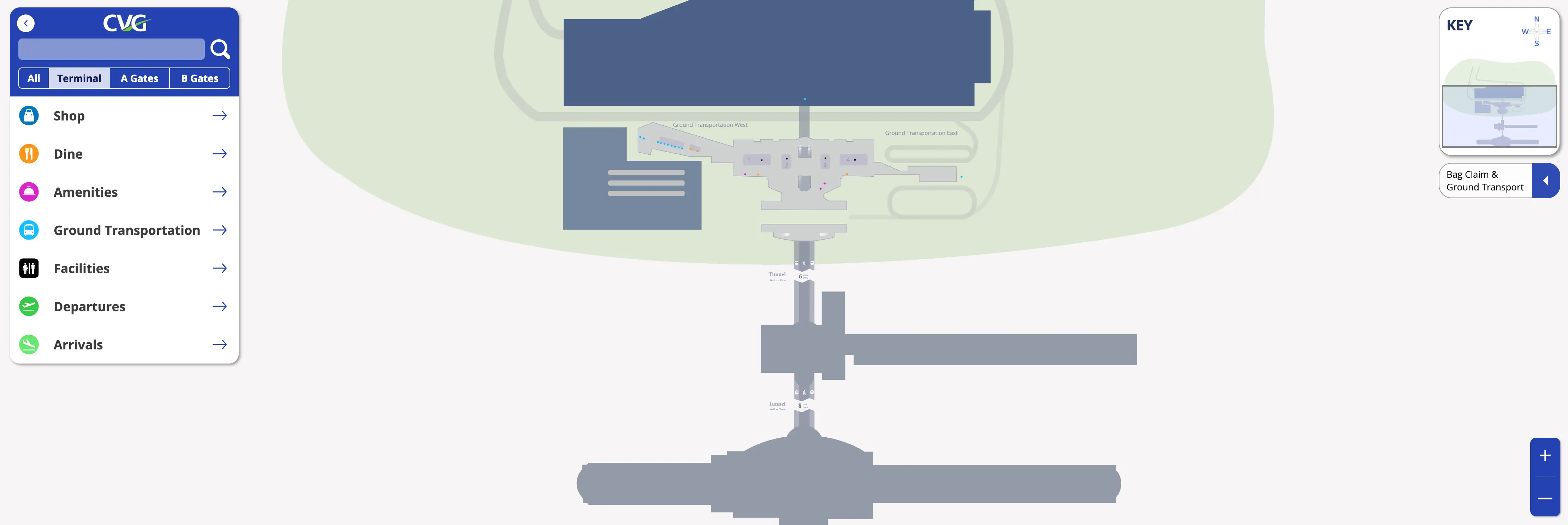
CVG uses a “decoupled” layout: a landside Main Terminal (ticketing, baggage claim, TSA) feeding two airside islands—Concourse A and Concourse B—linked only through the underground Transportation Hall tunnel with an APM train and moving walkways. Most passenger flow runs west–east from garage/curb into the Main Terminal, then down into the tunnel toward the concourses. Within Greater Cincinnati’s main airport complex, nearly every trip hinges on the tunnel decision point and the East/West ground-transport split.
Map Table
| Terminal | Key Airlines | Primary Function | Transfer Mode |
|---|---|---|---|
| Main Terminal (Level 2/1) | Delta, American, United, Southwest, Frontier, Allegiant | ticketing, bag drop, TSA, baggage claim | garage bridge, curb doors, escalator/elevator |
| Transportation Hall (Tunnel) | all carriers | concourse connector, APM platforms | train, moving sidewalks, pedestrian walk |
| Concourse A | American, United, Southwest, Allegiant, Breeze, Alaska | domestic gates (A1–A23) | APM stop, tunnel walk |
| Concourse B | Delta, British Airways, Air Canada | Delta-heavy gates, international arrivals, CBP | APM terminus, tunnel walk, post-customs re-screen |
Northern Kentucky International Airport Map Strategy
- Build a time buffer around the single-point funnel: parking/curb → ticketing level → one centralized TSA queue → tunnel descent, then assume the APM can be unavailable and plan the full tunnel walk as your baseline.
- Treat parking as two different systems: Terminal Garage equals Level 2 injection near TSA; Economy/ValuPark equals shuttle variability plus a forced vertical move from Ground Transport West up to Level 2.
- Lock in ground transport orientation before exiting baggage claim: East end for rideshare/taxi/TANK; West end for hotel and parking shuttles plus the Rental Car Center walk.
- International arrivals: expect a forced path—CBP exit feeds back into the secure side of Concourse B, then a mandatory TSA re-screen (duty-free liquids decision point happens inside customs, before that checkpoint).
2026 Northern Kentucky International Airport Map + Printable PDF
CVG’s core passenger geometry stays consistent in 2026: Main Terminal processing landside, then a required tunnel transfer to Concourses A/B. The biggest operational “gotchas” remain map-based—single centralized TSA, the 1,500-foot Transportation Hall dependency, and the international arrival loop that forces a TSA re-screen in Concourse B before you can ride back to baggage claim.
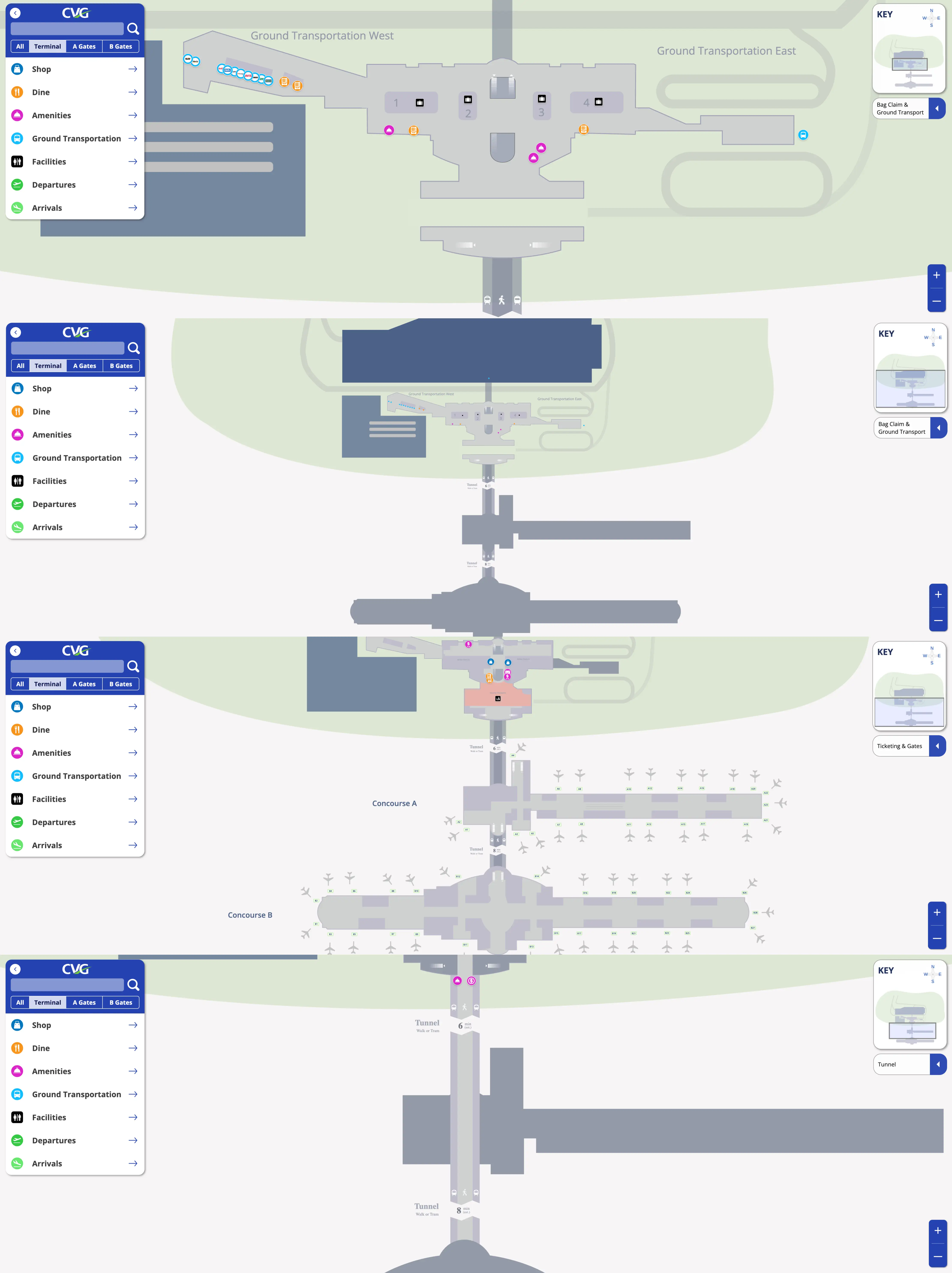
Northern Kentucky International Airport Terminal Map 2025
Northern Kentucky International Airport Baggage Claim Map 2025
Northern Kentucky International Airport Ticketing and Gates Map 2025
Northern Kentucky International Airport Tunnel Map 2025
2026 Northern Kentucky International Airport Map Guide
What is the exact pedestrian route (and walking distance) from the CVG parking garage elevators to the main security checkpoint entrance (fastest “garage → TSA” line-of-travel)?
Walking is under 200 feet from the garage-to-terminal bridge entry to the TSA queue entrance when you enter the Main Terminal on Level 2 (Ticketing Level). The fastest line-of-travel is the enclosed garage bridge into Level 2, then a straight, short indoor walk to the centralized checkpoint.
From the garage elevator lobby, go to the Level 2 enclosed pedestrian bridge into the Main Terminal and enter directly onto the ticketing level (bypassing curb traffic). Keep your line aimed toward the single TSA checkpoint and stop at the queue mouth where the wait-time monitor sits at the center of the security entrance. The only time add-on is inside the garage itself: premium-reserved areas sit closest to the bridge, so a farther stall increases the “car-to-bridge” portion before the sub-200-foot terminal walk begins.
In the Economy/Value lots, where are the primary shuttle pickup zones located by row/section, and what’s the shortest walk from a typical overflow parking row to that pickup point?
Shuttle pickup happens at numbered shelters (Shelter 1, Shelter 2, Shelter 3, etc.) spread through the Economy and ValuPark lots, not at one central depot. The shortest “overflow row → shuttle” walk is the stall-to-shelter hop when you park within the same aisle as a shelter, typically about 1–2 minutes on foot.
- Economy Lot pickup uses a distributed shelter loop; aim to park adjacent to Shelter 1 or Shelter 2 because buses can fill and bypass later shelters during surges.
- ValuPark also uses shelter-based pickup, with more “continuous stop” behavior due to luggage help, so the driver dwell time is longer at each shelter.
- If you land in a typical overflow row away from the first shelters, walk the nearest drive aisle toward the closest numbered shelter sign canopy; plan 2–5 minutes depending on how deep you’re parked.
- The reliability play is directional: drive past empty rows and choose a space closest to Shelter 1/2 even if it’s not the first spot you see.
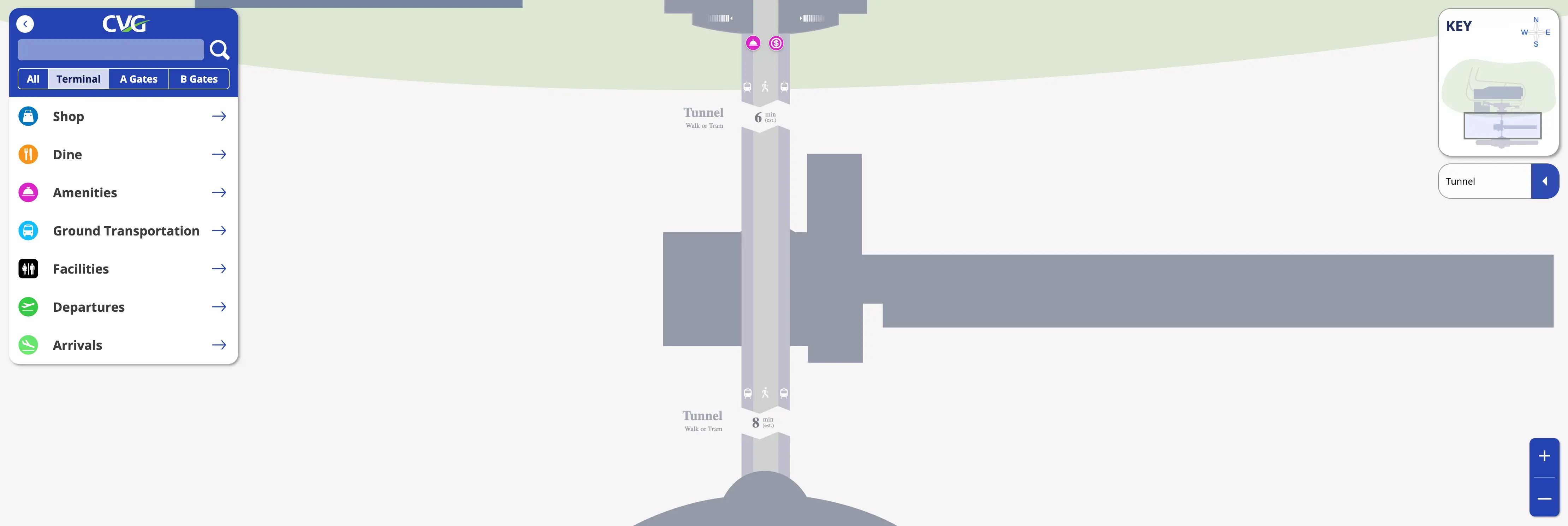
After clearing customs on an international arrival, what is the exact step-by-step path from the customs exit to the post-customs TSA re-screen point (including level changes/mezzanine access)?
Mandatory TSA re-screening happens immediately after you exit the CBP “dirty” area in Concourse B, before you can access the train/tunnel back to the Main Terminal. The path stays within Concourse B’s secured side and does not provide a direct landside exit.
After CBP processing, follow the exit flow out of the customs hall to the re-check area if you have duty-free liquids or items that must go into checked baggage. Continue along the controlled corridor that funnels you back into the “clean” Concourse B secure zone; the TSA re-screen point sits at that re-entry choke point before the Transportation Hall access. Once you clear that checkpoint, continue to the Concourse B tunnel/APM entrance area and take the train or walk back through the Transportation Hall toward the Main Terminal, then go up to baggage claim level after you return.
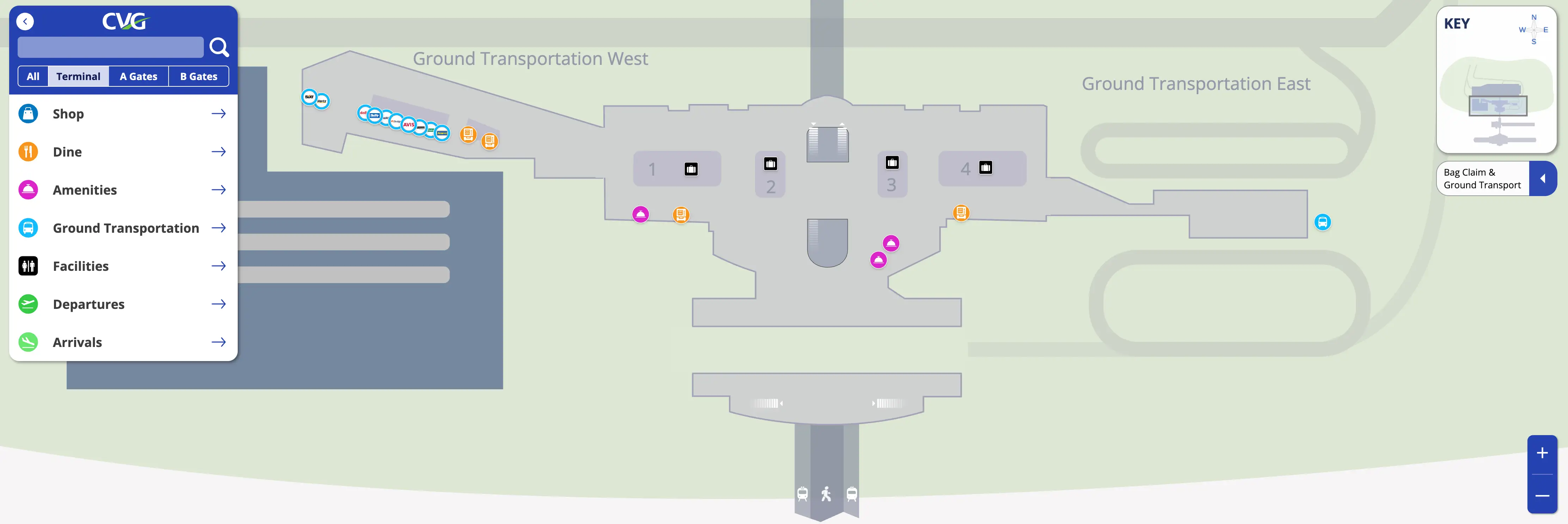
From Baggage Claim (carousel area), what is the exact signed walking route to the Rental Car Center (including which corridor—e.g., “Ground Transport West”—and the first “decision point” sign)?
The signed route goes to Ground Transport West, then continues directly into the attached Rental Car Center with no shuttle. The first decision point is inside the baggage claim hall where you must choose the East vs. West ground-transport direction before exiting the building.
| Step | What to follow | Landmark anchor |
|---|---|---|
| 1 | Overhead signs for Ground Transport West / Rental Cars | from the carousel area, start moving toward the terminal’s west end |
| 2 | Keep following Ground Transport West | stay inside until you reach the West exit doors and the ground-transport curb zone |
| 3 | Continue into the connected Rental Car Center walkway/entrance | Rental Car Center entry immediately off the Ground Transport West side |
| 4 | Proceed straight to the rental counters | counters inside the consolidated facility |
Longest inside walk is roughly the full terminal length from the far end carousel area (about ~800 feet from the far east side).
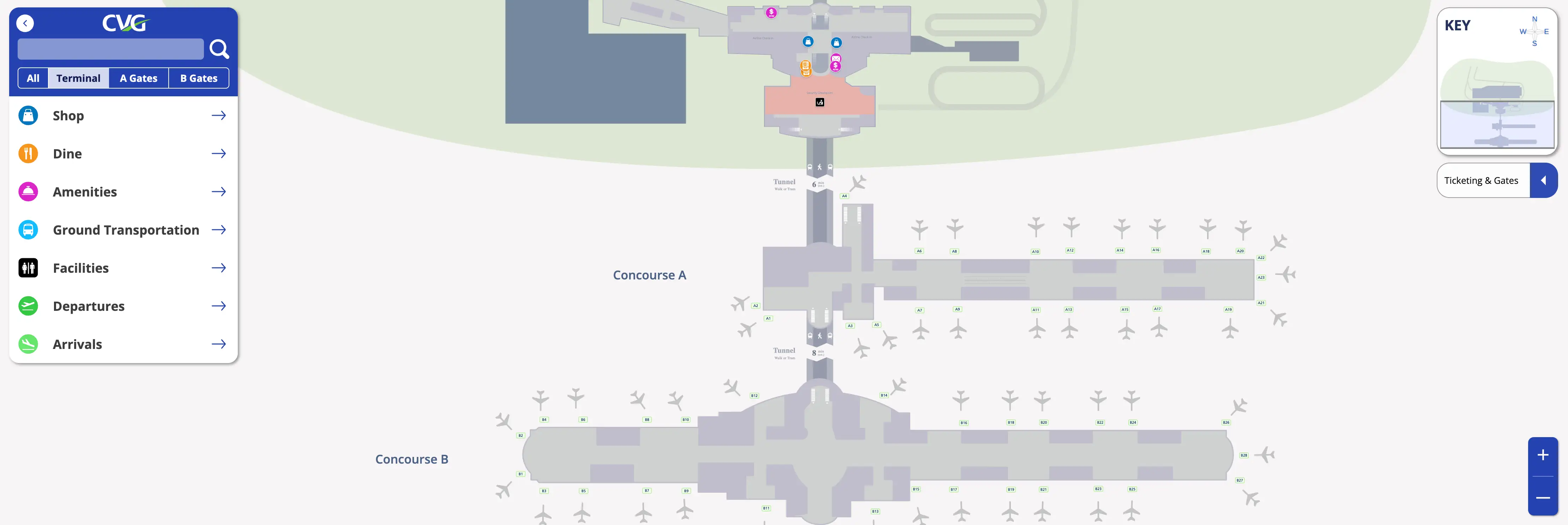
What is the longest “worst-case” walking time from security exit to the furthest active gate at CVG, and which specific gate area defines that maximum?
No train means a 15–17 minute continuous walk from the TSA exit to the furthest Concourse B gate area, with Gate B28 (east wing tip) defining the maximum. That worst case assumes the APM is unavailable and you must use the Transportation Hall walkways end-to-end.
| Segment | Line-of-travel anchor | Time |
|---|---|---|
| TSA exit → tunnel descent | follow signs down into the Transportation Hall | ~2 min |
| Transportation Hall walk → Concourse B | moving sidewalks + walk to the Concourse B end | ~8 min |
| Concourse B ascent → B-gates spine | up from the tunnel/APM node into the concourse | ~1–2 min |
| Concourse B spine → Gate B28 | all the way to the east wing tip gate cluster | ~5–7 min |
Where do parking shuttles and common off-airport shuttles drop passengers (exact door/curb zone), and what is the shortest indoor route from that drop to TSA?
Parking shuttles and most common off-airport/hotel shuttles drop at Ground Transport West on the terminal’s lower level curb zone, forcing a vertical move up to Level 2 before you can enter the TSA queue. The shortest indoor route is West curb → nearest escalator/elevator to Level 2 Ticketing → walk straight to the centralized security entrance.
From the shuttle curb at Ground Transport West, enter through the closest West-side doors into the baggage/ground-transport interior corridor, then take the nearest elevator or escalator up to Level 2 (Ticketing). Once on Level 2, orient toward the single TSA checkpoint and walk directly to the queue mouth where the wait-time monitor sits at the center of the entrance. Compared with the Terminal Garage bridge (Level 2), budget an extra 5–8 minutes for the drop-off system because of the vertical transition and indoor repositioning.
In Concourse B’s tunnel/escalator area, where is the customs egress relative to the “long escalators,” and what is the exact visual landmark that prevents taking the wrong escalator bank?
Customs egress feeds you back into the Concourse B secure zone near the tunnel/APM node rather than into a separate landside corridor, so you reappear in the same high-traffic area where passengers funnel toward the “long escalators” and the Transportation Hall access. The landmark that keeps you from taking the wrong escalator bank is the visible convergence of the tunnel/APM entrance flow—look for the concentrated stream of departing passengers and the Transportation Hall wayfinding cluster at the Concourse B node.
Because the audit data doesn’t name a unique fixed object (artwork/store/sign name) at that escalator split, the reliable “don’t get trapped” cue is directional: stay oriented to the Transportation Hall / train platforms signage and the main passenger stream rather than committing to an escalator bank before you confirm you’re headed to the tunnel/APM side.
For the busiest carriers (incl. low-cost counters), what is the exact location of their ticketing/bag-drop desks relative to the nearest curb door and the shortest path to TSA?
Delta’s ticketing/bag-drop is on the west (left) side of the Level 2 Ticketing Hall, closest to the west curb doors, while most other carriers’ counters sit to the east (right) of the main central entrance. The shortest path to TSA is always the direct Level 2 indoor walk from your carrier’s counter line to the single centralized security entrance.
| Carrier / group | Nearest curb positioning on Level 2 | Ticketing hall placement anchor | Shortest line-of-travel to TSA |
|---|---|---|---|
| Delta (hub carrier) | West-end drop, avoid crossing the hall | left of the main central entrance; highest density zone | finish bag drop, turn toward the single TSA entrance, walk straight to the queue mouth |
| Frontier (low-cost) | West-end drop | co-located in the west hemisphere with Delta | same as Delta; minimize lateral backtracking by using west curb doors |
| British Airways | West-end drop | west hemisphere near Delta zone | same west-to-center walk to the centralized checkpoint |
| American, United, Southwest | East/center drop | right of the main central entrance | east-to-center walk to the single TSA entrance |
| Allegiant, Breeze, Alaska, Air Canada | East/center drop | grouped on the east side past the main entrance | east-to-center walk; avoid being dropped at the Delta end to prevent a ~500-foot cross-hall traverse |
What is the exact driving route from the terminal loop to the Cell Phone Lot, and where is the re-entry merge point back to arrivals pickup (the spot that causes the most confusion)?
Driving uses I-275 Exit 4B (KY 212) to Hotel Drive, then into the Cell Phone Lot at 3401 Loomis Road. The confusing re-entry is the right turn from Hotel Drive onto Terminal Drive, where you must immediately merge left into Arrivals/Baggage Claim lanes or you’ll be forced into the recirculation/departure loop.
| Step | Follow signs for | Road move | Anchor point |
|---|---|---|---|
| 1 | Cell Phone Lot | Take I-275 to Exit 4B (KY 212) | exit ramp signage for KY 212 |
| 2 | Arrivals and Hotel | Continue toward the hotel/arrivals direction | approach to Hotel Drive |
| 3 | Cell Phone Lot | Turn right onto Hotel Drive, then enter the lot | Cell Phone Lot entrance at 3401 Loomis Road |
| 4 | Terminal / Arrivals | Exit the lot straight on Hotel Drive | lot exit back to Hotel Drive |
| 5 | Arrivals / Baggage Claim | Turn right from Hotel Drive onto Terminal Drive | merge point where Terminal Drive is already carrying arrival traffic |
| 6 | Arrivals pickup lanes | Immediately lane-shift left after the right turn | wrong-lane outcome: recirculation loop or unintended departure-level routing |
If upper garage levels are blocked or full, what is the closest alternate parking option by drive-time within airport property, and where is its pedestrian/shuttle interface on the map?
CVG Valet is the closest on-property fallback when the Terminal Garage is full, because it’s located at the terminal on the baggage-claim level and avoids the remote-lot shuttle loop. The interface is the valet curb/drop area at the Main Terminal (baggage-claim level) with a direct indoor connection into the terminal.
After valet, the next closest functional fallback is ValuPark (then Economy), but those shift you into the shuttle system and typically drop at Ground Transport West, adding the vertical move up to Level 2 for ticketing and TSA. If you’re already committed to remote lots, the map-critical node is the Ground Transport West curb where the shuttles unload and where you start your fastest indoor route to the escalators/elevators up to TSA.
Where exactly are TSA wait time displays/signage located landside, and at what point do they become visible relative to the queue entrance (so travelers can decide to reroute/check alternatives)?
The TSA wait time display is at the center of the main security entrance and becomes visible only at the point you reach the checkpoint frontage, essentially at the queue mouth. That means it’s “point-of-decision” for choosing a lane (PreCheck vs. General) but not “pre-decision” for changing your overall approach from the garage or curb.
The monitor sits at the security entrance area on Level 2, so you generally won’t have line-of-sight to it while you’re still in the garage bridge corridor or at curb doors until you’ve already walked into the security zone. Overhead digital signage above the entrance identifies lane configuration (PreCheck vs. General) and can change, so the practical decision moment is when you’re directly in front of the queue entrance and can read the monitor and gantry signs together.
Where are the least-used bag-drop alternatives (e.g., skycap positions) located relative to the main ticketing banks, and what is the shortest approach path from curb?
Curbside check-in (skycap-style positions) is the primary low-friction bag-drop alternative, and it sits on the terminal curbside rather than inside the Level 2 ticketing banks. The shortest approach is a direct curb drop at the door nearest your airline’s end of the ticketing hall, then a minimal sidewalk walk to the curbside check-in position serving that curb segment.
There isn’t a “hidden” lower-level check-in at CVG: Ground Transport West has luggage carts but no airline counters, so you cannot shortcut ticketing from the shuttle side. If curbside check-in is operating, use it as a queue bypass; if it’s closed (hours can be limited), the only functional bag-drop node is the Level 2 ticketing hall for your carrier, then the short indoor walk to the centralized TSA entrance.