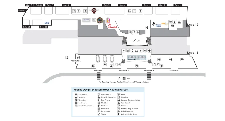
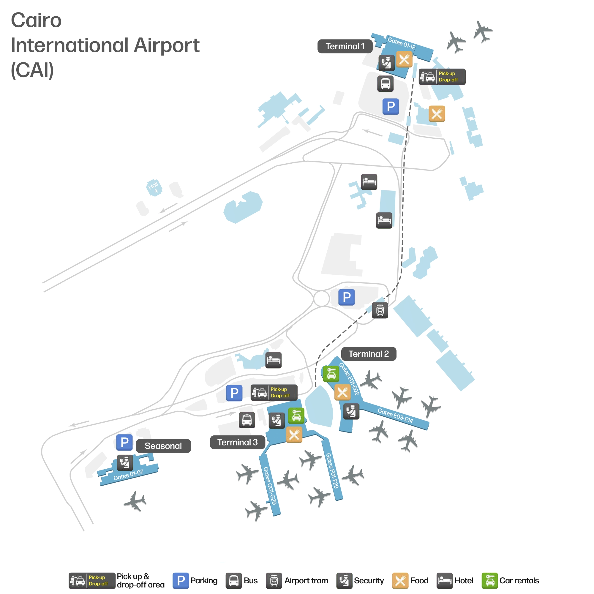
Cairo International Airport Map (Most Up-To-Date)
Cairo International Airport (CAI) is a multi-terminal campus with a clear “hub-and-satellites” shape: Terminals 2 and 3 form the main connected core, while Terminal 1 and the Seasonal Terminal sit apart as detached spokes. Within Cairo’s main airport complex, the layout is organized around an enclosed connector bridge (walkable) and an Automated People Mover (MiniMetro) that handles the longer gaps. The Seasonal facility lies west of Terminal 3, requiring a shuttle.
Map Table
| Terminal | Key Airlines | Primary Function | Transfer Mode |
|---|---|---|---|
| Terminal 2 | SkyTeam partners | International departures/arrivals | T2↔T3 bridge, walk |
| Terminal 3 | EgyptAir, Star Alliance | Primary hub terminal, intl + some domestic | T2 bridge; APM to T1; shuttle to Seasonal |
| Terminal 1 | Mixed/legacy carriers | Satellite terminal, domestic/intl mix | APM (primary), shuttle bus (fallback) |
| Seasonal Terminal | Hajj/Umrah seasonal ops | Mass-processing seasonal flights | Shuttle bus only |
Cairo International Airport Map Strategy
- Treat T2 + T3 as one connected complex; walk the enclosed bridge for T2↔T3 moves instead of hunting for vehicles.
- Decide airside vs landside early: “Connecting Flights/Transfer” routes bypass immigration; the wrong descent forces a full landside reset.
- Budget for three screening layers in Terminal 3: door screening, central core screening, then gate-pen screening that traps you inside the lounge.
- For T1 and the Seasonal Terminal, commit to the correct mode: APM for T1; shuttle bay on the arrivals curbside for Seasonal—no safe/viable walking links.
2026 Cairo International Airport Map + Printable PDF
Layered screening defines CAI in 2026, so the “shortest line” route matters as much as the shortest walk. Terminal 2 and Terminal 3 operate like one building via the enclosed connector bridge, while Terminal 1 remains a separate satellite best reached by the MiniMetro APM. Gate-area checks in Terminal 3 create a final choke point that changes when you should leave the concourse for boarding.
2026 Cairo International Airport Map Guide
What is the exact walking route and distance from Terminal 3 arrivals (transfer corridor entry) to Terminal 2 departures check-in hall?
A direct landside bridge walk takes about 500 meters from Terminal 3’s departures-level public connector entry to Terminal 2’s departures check-in hall entrance. From Terminal 3 arrivals, the practical route is a vertical move up to departures, then straight onto the enclosed public connector toward Terminal 2.
After clearing Customs into the Terminal 3 Arrivals Hall, head immediately to the main escalator/elevator bank up to the Departures Level (the level with check-in counters and curbside drop-off). Follow signs for “Terminal 2” to the entrance of the enclosed connector bridge, then stay in the public channel across to Terminal 2. The bridge run is the cleanest path because it avoids the road loop; midway you’ll pass the APM station access—ignore it for T2 because the walk is faster than waiting.
Where is the Terminal 1 ↔ Terminal 3 inter-terminal train/shuttle pickup point located (landside), and what is the walking distance from the Terminal 3 main entrance to that pickup point?
The Terminal 1 ↔ Terminal 3 primary pickup point is the MiniMetro (APM) station integrated between Terminals 2 and 3 on the landside connector spine, not at the Terminal 3 curb itself. The walk starts at Terminal 3’s main entrance doors, continues into the T2–T3 connector building/bridge approach, then drops or rises to the APM platform level.
Terminal 1’s MiniMetro station is a standalone building beside Terminal 1 Hall 1, reached by following station signs out from the T1 public hall. The fallback shuttle-bus pickup uses the curbside arrivals lanes (Terminal 3 lower-level curb), with Terminal 1’s bus pickup at the parking/bus area in front of Terminal 1. For routing certainty, anchor on the T2–T3 connector bridge structure: the APM station sits on that spine between the two terminals, then you ride the 1,857 m line to the T1 Hall 1 station.
In Terminal 3, what is the exact location (landmark + level) of the gate-area security entry for the C-shaped/two-zone departures layout?
The gate-area security entry in Terminal 3 is at the single opening of each glass-walled gate “pen” directly off the departures pier corridor on the international concourses (F and G). The checkpoint sits at the pen threshold—an x-ray belt and magnetometer positioned where the main concourse feeds into the enclosed boarding lounge.
From the central departures retail core (duty-free spine) you walk out along Concourse F or G; the gate pen appears as a glass partition set back from the corridor edge, with one obvious mouth where a podium, queue stanchions, and the screening equipment block entry. That pen entrance is the last screening layer: once you pass it, you’re confined to the holding lounge for that gate (often with limited facilities). If you’re looking for a “two-zone” behavior, think “shops/toilets in the open concourse” versus “sealed gate lounge behind glass,” with the security entry exactly at the seam between them.
From Terminal 3 immigration exit, what is the walking distance to baggage claim belt areas, and where does the path split (if at all) between halls?
Walking runs about 30–50 meters from the last immigration booth to the top of the down-escalator/travelator bank, then about 100–150 meters from the bottom of that descent to the customs exit, depending on which baggage carousel you’re assigned. The route is essentially linear until after customs.
After passport control on the arrivals mezzanine, follow the forced corridor to the escalators/travelators that drop into the baggage hall. Carousels sit in a single open-plan hall rather than a true hall-vs-hall choice, so there’s no meaningful “split” before customs—everyone funnels through the same inspection zone. The first real path split happens after customs into the public arrivals lobby: one direction toward the taxi/limo curbside and greeting rail, the other toward the connector spine for the APM station, parking, and the Terminal 2 link.
What is the airside path (corridor/walkway) from Terminal 3 international gates to Terminal 2 international gates, and where exactly does it start inside T3?
The airside transfer path is the secure connector corridor that begins at Terminal 3’s central transfer core before the immigration descent, then runs across the enclosed T2–T3 connector bridge into Terminal 2’s departures concourse. The start point is the “Transfer/Connecting Flights” channel at the junction where Concourses F and G feed back into the central core.
From an inbound international gate on Concourse F or G, follow “Transfer / Connecting Flights” signs and stay on the level that bypasses immigration. At the transfer core, look for the specific “Terminal 2” direction; a document check or transfer desk often guards the corridor entrance, followed by a mandatory transfer security x-ray either at the bridge entry or on the Terminal 2 side. The walkway uses moving travelators and stays separated from the public landside bridge by glass partitions, depositing you into Terminal 2’s international gate-area/duty-free zone.
Where is the transfer/transit desk located for passengers being driven apron-side to another terminal, and what is the walking distance from the nearest central concourse point to that desk?
The apron-bus transfer/transit desk is immediately inside the ground-level bus-gate glass doors, positioned before the flow rises toward immigration. The walking distance from the bus drop-off door to the desk is under 20 meters.
Passengers arriving from remote stands are discharged at the ground-level “Bus Gates” at the base of Terminal 3. Step through the glass entry doors and you’ll see the transfer desk in that intake zone, used for printing onward boarding passes and steering eligible passengers to the “Transfer Up” escalators instead of the immigration descent. The critical constraint is directional: if you miss this desk and take the wrong escalator toward immigration, you effectively exit the transfer path and create a forced landside sequence to get back airside.
What is the exact shuttle-bus pickup bay location for transfers from Terminal 3 to the Seasonal Terminal, and what is the walking distance from T3 arrivals to that bay?
The Seasonal Terminal shuttle picks up on Terminal 3’s arrivals curbside (lower level), organized from the arrivals-area “Shuttle Bus Customer Service Counter” that acts as the identification node for the correct bus. The walking route runs from the customs exit into the arrivals lobby, then straight out to the arrivals curb lanes.
From the Terminal 3 customs exit, stay inside the arrivals hall long enough to locate the shuttle/customer-service counter for inter-terminal and seasonal transfers, then exit through the nearest arrivals doors to the lower curbside where the shuttle bays load. This matters because multiple buses can share the curb loop; the Seasonal Terminal bus is not the same as a generic inter-terminal loop and can otherwise send you into a non-stopping circuit. Operationally, expect lower frequency service (about every 30 minutes) and a road ride west toward the Seasonal facility.
If transferring to domestic by foot, what is the exact outdoor segment length (meters) and route (ramp/sidewalk) from Terminal 3 to the domestic terminal entrance?
A safe on-foot outdoor route from Terminal 3 to a “domestic terminal” outside Terminal 3 is not available because the practical domestic alternative is Terminal 1, and the road/highway geometry makes walking non-viable. The only reliable connection for a domestic departure that isn’t handled inside Terminal 3 is the MiniMetro APM link to Terminal 1.
If your domestic flight is EgyptAir and operates from Terminal 3, the “transfer by foot” is internal: clear customs, then walk roughly 200–300 meters inside Terminal 3 to the domestic check-in/domestic hall area—no outdoor segment required. If your domestic flight runs from Terminal 1 (common for non-EgyptAir domestic operations), treat Terminal 1 as a separate satellite: go landside to the APM station on the T2–T3 connector spine, ride the 1,857 m line to the Terminal 1 Hall 1 station, then walk into Hall 1. Attempting to walk curbside/roadside between T3 and T1 involves highway ramps and is strongly advised against.
In Terminal 3, where are the three primary screening points located on the physical path (entrance screening → main security → gate screening), and what are the walking distances between each?
The three screening points in Terminal 3 are staged as door screening at the curbside entrance, a central-core security layer immediately after passport control, and a final x-ray/magnetometer at each gate-pen entrance on Concourses F and G. Walking distance runs essentially 0 meters from curb to door screening, then about 100–150 meters from check-in counters to the central-core layer, then about 300–800 meters from the central duty-free spine to the specific gate-pen checkpoint.
| Segment | Screening node location | Walk distance |
|---|---|---|
| Entrance → main hall | 5 m inside sliding doors from curbside | ~0–5 m |
| Check-in zone → central core | Immediately after passport control / emigration core | ~100–150 m |
| Central core → gate screening | Gate “pen” entrance off Concourse F or G corridor | ~300–800 m |
The key constraint is one-way flow at the last layer: once you pass gate-pen screening, you’re confined to that lounge, so the practical “distance” includes queue spillback into the concourse corridor during wide-body boarding.
What is the best landside meeting point in Terminal 3 (outside security) by named landmark, and what is its walking distance to each arrivals exit door cluster?
The best landside meeting point in Terminal 3 is the Toulip café/food court area inside the Arrivals Hall, set back from the customs exit barricade. It sits about 30–50 meters from the customs exit and about 20–40 meters from the curbside exit doors.
Use the Toulip area as the anchor because it’s visually distinct, has seating, and avoids the congested “customs chute” where people spill out into solicitors and crowding. From customs, do not step outside immediately; move into the main hall atrium and meet at the Toulip landmark, then walk together to whichever arrivals doors are closest for pickup. This keeps the rendezvous stable even if you exit through different door clusters.