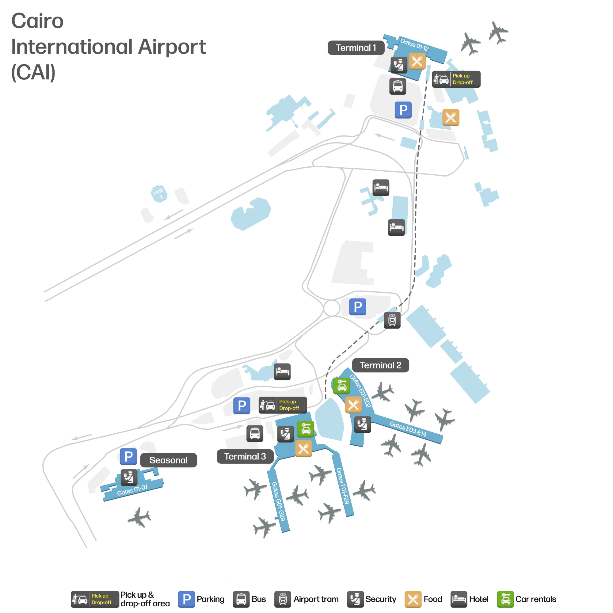
Cairo International Airport Terminal 2 Map (Most Up-To-Date)
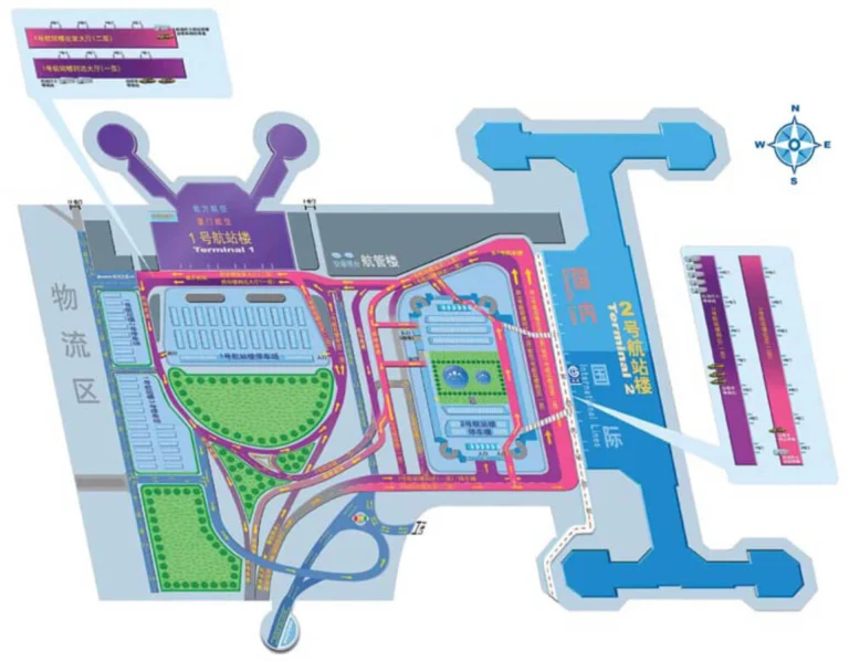
Cairo International Airport Terminal 2 is a compact, vertically stacked terminal with a short landside frontage and a linear airside concourse that fans out to gate piers. Most “distance” stress comes from process layers (entry screening, immigration, secondary security) rather than long walks. Within Cairo’s main airport hub, Terminal 2’s key orientation feature is the enclosed Terminal 2–Terminal 3 pedestrian bridge, which typically requires a level change (ramp/elevator) to access cleanly.
Map Table
| Level/Zone | Primary Nodes | Connected To | Transfer Mode |
|---|---|---|---|
| Arrivals level (public) | customs exit doors, arrivals hall | Terminal 3 | enclosed pedestrian bridge, landside walk |
| Arrivals level (airside edge) | “Connecting Flights/Transit” signage, transfer desk/room | Terminal 3 | airside bus, staff-controlled |
| Departures hall | entry screening X-ray, check-in islands | airside processing | walk, queue lanes |
| Post-immigration airside | corridor right-turn, second security X-ray | lounge + concourse | walk |
Cairo International Airport Terminal 2 Map Strategy
- Treat every level change as a decision point: if you’re aiming for Terminal 3, look for the elevated/enclosed bridge access and use the ramp/elevator rather than drifting into curbside traffic.
- Lock onto queue-split logic early: at arrivals immigration, visa-on-arrival bank kiosks sit before the desks—joining the wrong line often means a full restart from the back.
- Assume security repetition: plan for an initial entry screening, then outbound immigration, then a second security checkpoint for certain airside corridors (notably the lounge approach).
- Reduce “helper” pressure by staying in motion past customs exit doors; step aside only after you’ve cleared the intercept zone and reached a defined anchor (bridge approach, signed transit desk, or official shuttle sign).
2026 Cairo International Airport Terminal 2 Map + Printable PDF
Terminal 2 remains the renovated (reopened 2016) “compact-but-procedural” terminal in the CAI network: short walks, frequent choke points. The most important 2026 printable-map detail is separating landside vs airside transfers to Terminal 3—walking the enclosed bridge is typically faster and more predictable than waiting for shuttles, while true airside connections depend on a staff-run transfer room and bus dispatch.
2026 Cairo International Airport Terminal 2 Map Guide
What is the exact walking route (turn-by-turn nodes) from Terminal 2 Arrivals exit to the Terminal 2 ↔ Terminal 3 airbridge connection point?
The Terminal 2 ↔ Terminal 3 pedestrian bridge starts from Terminal 2’s public Arrivals side and is reached by exiting Customs into the Arrivals Hall, then moving laterally toward Terminal 3 wayfinding and the elevated connector access.
From the Customs Exit doors, walk straight into the public Arrivals Hall until you clear the densest “meet/assist/porter” cluster, then angle toward signs for Terminal 3 / connections and head to the enclosed, air-conditioned bridge approach. Use the level-change access (ramp/elevator) that lifts you to the bridge height; the key landmark on the Terminal 3 side is the ramp that brings you up to Terminal 3 Departures (the ramp appears on the left as you near Terminal 3 Arrivals). If you find yourself curbside in open traffic lanes, you’ve missed the protected bridge vector—turn back inside and re-find the signed connector approach.
Where is the Terminal 2 inter-terminal shuttle bus stop located relative to the main Terminal 2 doors (which curb/level/side)?
The Terminal 2 inter-terminal shuttle stop sits on the Arrivals-level curb right outside the main public doors, set slightly off the primary drop-off lane along the terminal frontage.
From the Terminal 2 Arrivals Hall, exit through the main Customs/Arrivals doors to the curb and immediately scan along the façade for the airport shuttle sign (typically blue/white) rather than walking toward the parking structure. The stop is usually positioned to the side of the busiest vehicle flow so buses can load without blocking cars. If you reach the first parking/garage access point or start crossing traffic lanes away from the building face, you’ve gone too far—reset to the doors and trace the curb line laterally until the marked shuttle area appears.
What is the walking distance (meters) from the Terminal 2 check-in hall entrance to the first security screening point passengers must pass?
The walking distance is under about 200 meters, because the first security screening sits almost immediately after entering the Terminal 2 departures hall.
Terminal 2’s departures frontage is shallow: once you pass through the main doors into the check-in hall, the initial baggage X-ray/entry screening banks are positioned at the front-of-house processing edge before you fully penetrate the check-in islands. The practical “distance risk” is queue depth, not walking—if you can see the check-in islands but haven’t cleared an entry X-ray yet, you’re likely still upstream of the first security node. During peaks, the effective time cost comes from crowd compression at the doorway-to-screening funnel rather than any long corridor.
Where exactly does the Terminal 2 queue split by destination/airline (the point where people get redirected to a different line)?
The main “restart” queue split happens at the entrance to the Arrivals Immigration Hall, where lanes separate by passenger type and visa readiness before you commit to a desk line.
As you come off the arrivals corridors into immigration, the first decision is whether you need a visa-on-arrival sticker: the bank kiosks selling visas sit immediately before or to the side of the immigration desk area, and joining an officer line without the sticker is the common failure that forces a full backtrack and re-queue. After that, the physical lanes divide into Foreign Nationals, Egyptian Citizens, and Diplomats right at the front of the hall near the stanchions. Use the bank-kiosk edge as your anchor—if you can’t see the kiosks anymore, you’ve likely already committed to the wrong lane geometry.
What is the shortest indoor path from Terminal 2 immigration/passport control to the primary baggage-claim carousel area?
The shortest path is the straight-through immigration exit to the escalator descent that drops directly into the baggage-claim hall.
After your passport is stamped at immigration, continue forward with the main flow rather than peeling toward side corridors, then take the first clearly marked downward transition (typically an escalator) from the immigration level to the baggage-claim level. The baggage hall opens immediately at the base of the descent, with the primary carousel banks arranged as the dominant open area straight ahead. The critical constraint is one-way flow: once you commit to the descent out of immigration, reversing back up to immigration is effectively blocked, so confirm you are finished at the immigration desks (and have any required visa sticker handled earlier) before moving down.
Where is the “transfer / connections” desk (or decision point) inside Terminal 2 located (landside vs airside, and which level)?
The transfer / connections decision point is airside on the Arrivals level, before the escalator down to the Immigration and baggage-claim hall.
After you leave the aircraft and enter the arrivals corridors, follow signs for “Connecting Flights” or “Transit” and do not descend toward immigration. The desk/holding-room area sits at this upper arrivals level edge, commonly described as a small transfer room or desk with an officer where passengers are asked to wait outside while the airside bus transfer is arranged. The dealbreaker is the escalator threshold: once you go down into the immigration hall as a transit passenger without a visa, reversing back to the transit desk becomes administratively difficult and can cost substantial time.
What is the walking time from the Terminal 2 shuttle drop-off point to Terminal 2 departures security under normal flow (no queue)?
Walking takes under 3 minutes, because the shuttle drop-off is right on the Terminal 2 curb and the first departures security screening is just inside the main doors.
From the bus, walk directly to the nearest Terminal 2 entrance doors on the same curb line (stay tight to the building face), enter the departures hall, and you should reach the initial entry screening X-ray almost immediately. The time variance comes from whether the bus drops you opposite the “active” doors or one section down the linear frontage; even then, the terminal’s shallow footprint keeps the walk short. If you’re walking more than a couple of minutes outdoors or toward parking/ramps, you’ve drifted away from the façade and away from the fastest security approach.
Which specific corridor/overpass do passengers walk through when transferring T3 → T2 as described in common transfer guidance (name/signage landmarks)?
Passengers walk through the enclosed, air-conditioned pedestrian bridge (the Terminal 2–Terminal 3 overpass) that connects the upper levels of the two terminals.
From Terminal 3, follow wayfinding for Terminal 2 (often grouped with “Terminal Transfer” or “Connecting Terminals”) and aim for the elevated connector rather than curbside exits. The defining landmarks are that the corridor is modern, well-lit, and enclosed, and it deposits you at bridge height rather than ground level; if you are at open-air vehicle lanes, you are not on the overpass route. On the Terminal 3 side, the practical navigation cue is the ramp that lifts you from the arrivals side up to departures level—using that vertical transition aligns you with the overpass height and avoids the chaotic arrivals curb.
Where are the largest seating/waiting clusters landside in Terminal 2 for passengers blocked by the 3-hour entry rule?
The largest reliable seating clusters are not in Terminal 2 landside; they are in Terminal 3 landside, especially around Level 3 near the food court and Zone H.
Terminal 2’s public (landside) area functions mainly as circulation and has sparse seating, so passengers arriving earlier than the 3-hour rule can end up standing along walls near the arrivals/public zones. The dependable workaround is to walk the enclosed Terminal 2–Terminal 3 bridge and wait in Terminal 3’s landside concourse where benches and food-court seating are concentrated. Use the Terminal 3 Level 3 food-court zone as the anchor: if you can see clustered dining and “padded bench” style seating, you’re in the right waiting basin; if you’re in a tight hallway with intermittent chairs, you’re still in the Terminal 2 landside vacuum.
What is the exact location of the Terminal 2 Plaza Premium/CAC lounge relative to the main post-security spine (which direction from the central concourse)?
The Plaza Premium/CAC lounge is on the airside 1st floor and sits to the right off the post-immigration corridor, reached only after passing a second security checkpoint.
After outbound passport control, turn right immediately instead of continuing straight toward the duty-free/gates spine. Follow that right-hand corridor until you reach an additional cabin-bag X-ray (the “second security” layer); once you clear it, the lounge entrance is on the right. The confirmation landmark is that second security point—if you have exited immigration and you are already in the main duty-free/gate flow without seeing another X-ray, you missed the right turn and will need to backtrack to the passport-control exit area to reset.
Where are the most common “approach points” for porters/helpers (typical intercept zones) along the Terminal 2 curb-to-check-in path?
The highest-pressure approach zone is the immediate radius outside the Terminal 2 Arrivals/Customs exit doors, where passengers slow down to orient themselves.
- Customs/Arrivals exit doors to curb edge: tight semicircle directly outside the public doors, especially where people stop with luggage carts.
- Terminal frontage “dead stop” spots: any pillar or wall section just beyond the main doors where travelers check phones before moving toward departures entry screening.
- Connector drift zone toward Terminal 3: the first stretch of the T2→T3 walking direction when passengers hesitate to find the bridge/ramp access.
- Curbside vehicle negotiation points: the moment you pause at the drop-off lanes to talk to a driver or compare cars, usually within one lane of the terminal façade.
What is the shortest route from Terminal 2 security exit (post-screening) to the furthest gate cluster (identify the gate-zone boundary that creates “long-walk” anxiety)?
Walking takes under 10 minutes, because Terminal 2’s post-security concourse feeds a single central hub into linear piers where the furthest gate cluster sits at the end of the numbering run.
From the security exit, stay on the main concourse spine until the first major pier split, then follow the overhead gate-number signage toward the highest gate numbers (often the F/G-designated extremity or the last-numbered gates along the pier). The “long-walk” boundary is the point where the concourse stops feeling like a central hall and becomes a narrow, linear pier—once you pass that constriction and the amenities thin out, you’re committed to the furthest cluster. Also watch for bus-gate cues: if your “Gate” signage starts pointing down to a holding area rather than along the pier, you may be routing to a bus boarding zone rather than a distant jet bridge.