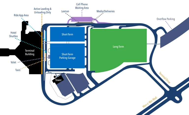
Minneapolis Saint Paul International Airport Ground Transportation Map (2025-2021)
Wayfinding starts curbside. The Minneapolis Saint Paul International Airport Ground Transportation Map outlines how MSP (Minneapolis Saint Paul International Airport) connects its two terminals—1-Lindbergh and 2-Humphrey—via the free Light Rail Transit (METRO Blue Line) and dedicated roadway network.
That’s why travelers use the Light Rail platforms for quick transfers or onward travel downtown.
Open the Minneapolis Saint Paul International Airport Ground Transportation Map to locate taxi stands, ride-share zones, bus bays, and rail links—just follow the blue “Ground Transport” and “Light Rail” signs on the Tram and Arrivals levels.
Minneapolis Saint Paul International Airport Ground Transportation Terminal 1 Map 2025
In 2025, Minneapolis–Saint Paul International Airport completed a decade-long modernization of Terminal 1.
The terminal footprint expanded 16 feet toward the roadway, consolidating security screening into two larger checkpoints and introducing upgraded baggage carousels and building systems.
The $305 million phase widened the central concourse corridor, increased gate seating capacity by 52 percent, and expanded international arrivals facilities, all aimed at reducing congestion and improving passenger flow within the terminal’s ground transportation and access areas.

Minneapolis Saint Paul International Airport Metro Blue Line Route Map 2025
In 2025, the Metro Blue Line experienced a complete shutdown from September 22 to October 4 for maintenance under the “Renew the Blue” project, during which replacement buses served all stations.
Upon completion, trains resumed operations on October 4 with faster service intervals, running every 12 minutes.
Additionally, in August, the Federal Transit Administration approved the final environmental statement for the Blue Line Extension, confirming 13 new stations and a $10 million community support initiative.

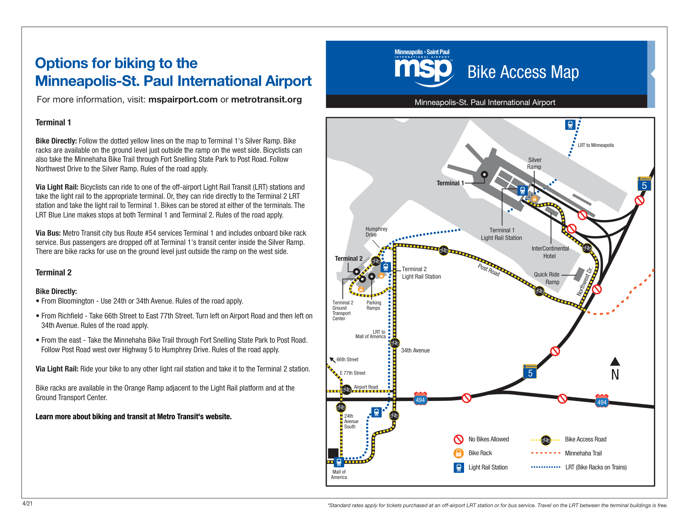
Minneapolis Saint Paul International Airport Bike Access Map 2025-2021
Minneapolis Saint Paul International Airport introduced several key updates for bike access. In April 2024, Saint Paul adopted an updated Bicycle Plan integrating airport routes.
Post Road access to Terminal 2 was closed for several weeks and reopened on September 28, 2024.
By October 2024, a new two-way protected bike path was completed along Post Road on the south side, linking directly to Terminal 2 for improved cyclist connectivity.
Minneapolis Saint Paul International Airport Bus Operator Instructions Terminal 1 Map 2025
In 2025, Minneapolis Saint Paul International Airport’s Terminal 1 completed its $600 million Operational Improvements Program, expanding the terminal by 17,000 square feet and consolidating security into two main checkpoints.
MVTA introduced new daily Route 436 bus service to Terminal 1 beginning September 2.
Additional updates included higher capacity baggage systems, improved lighting and seating, expanded restrooms with adult changing tables, and ongoing modernization of six concourses and 75 Delta gate hold rooms.

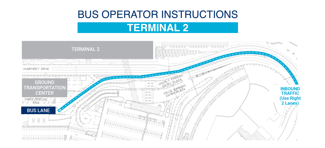
Minneapolis Saint Paul International Airport Bus Operator Instructions Terminal 2 Map 2025
In 2025, Minneapolis–Saint Paul International Airport’s Terminal 2 saw redevelopment of its concessions, with the MAC approving new and redesigned food and retail concepts in February.
Construction that began in 2024 continued to expand the terminal’s north end with two new gates, restrooms, and concession areas.
Bus operations added two new services: SouthWest Transit’s Route 686L launched March 31, and MVTA’s Route 436 began service to Terminal 2 on September 2.
Minneapolis Saint Paul International Airport Express Pick Up and Drop Off Terminal 2 Map 2025
In 2025, Minneapolis–Saint Paul International Airport expanded Terminal 2 operations with several key updates.
A new Express Lane opened on the second level of the Purple Ramp, offering dedicated pick-up and drop-off access via a sky-bridge to the terminal.
The MAC board approved a major concessions redevelopment, introducing redesigned concepts and replacing Mpls. St. Paul News & Gifts with Hometown Market.
Additional updates include a relocated Subway, a new McDonald’s, and refreshed Caribou Coffee and illycaffè locations.

Printable Minneapolis Saint Paul International Airport Ground Transportation Map PDF 2025
FAQ
How to get to ground transportation at MSP?
To reach ground transportation at MSP, follow the signs for “Baggage Claim” after your flight, then continue to the Ground Transportation Center located on Level T of Terminal 1 or Level 1 of Terminal 2. Shuttles, rideshare, taxis, and light rail are all accessible from these levels.
Is there a shuttle service from the Minneapolis airport?
Yes, Minneapolis–Saint Paul International Airport (MSP) offers shuttle service through several providers. Shared ride shuttles and hotel courtesy shuttles operate from the Ground Transportation Center at Terminal 1 and Level 1 at Terminal 2. Reservations may be required depending on the provider.
How do I get from Minneapolis airport to downtown Minneapolis?
Get from Minneapolis–Saint Paul International Airport (MSP) to downtown Minneapolis by taking the Metro Blue Line light rail from Terminal 1 or Terminal 2. Trains run every 10–15 minutes and reach downtown in about 25 minutes. Taxis, rideshares, and shuttles are also available from ground transportation areas.
Does Uber pick up at MSP airport?
Yes, Uber picks up passengers at Minneapolis–Saint Paul International Airport (MSP). At Terminal 1, follow signs to the Ground Transportation Center on Level T. At Terminal 2, go to Level 1. The Uber app provides exact pickup zones for each terminal and vehicle type.