Shanghai Pudong International Airport Ground Transportation Map (2025)
The Shanghai Pudong International Airport Ground Transportation Map lays out how travelers connect between Terminals 1 and 2 and reach central Shanghai.
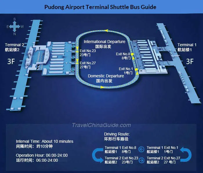
That’s because Pudong Airport (PVG) is built around two large terminals linked by an inter-terminal shuttle and the landside Metro station for Line 2. Look for the “Transfers” arrows near the Maglev and Metro exits to orient yourself quickly.
Use this Shanghai Pudong International Airport Ground Transportation Map to find taxi ranks, Maglev and Metro lines, and airport shuttle routes. Arrivals and departures are split by level, so follow curb signage before boarding. The map helps you plan each link—from curb to city—without confusion.
Shanghai Pudong International Airport Ground Transportation Map 2025
In 2025, Shanghai Pudong International Airport introduced eight upgraded ground transit services, including new 24-hour customs, immigration, and security screening for all outbound international flights.
The airport launched the “worry-free transit” program with 13 rest pods and 11 shower rooms, and implemented 24-hour convenience stores and flexible dining hours.
The PuLe GO mini program enabled robot-delivered food and shopping, while Swissport’s intelligent cargo terminal began operations in the West Cargo Area.
Shanghai Pudong International Airport Bus Traffic Route Map 2025
In 2025, Shanghai Pudong International Airport removed two low-demand bus routes: Airport Line 1, linking Pudong Airport and Hongqiao Transport Hub, and Airport Line 9, connecting to Xinzhuang.
Concurrently, Airport Line 7 was rerouted to a shorter path via the Outer Ring Road to improve efficiency between Shanghai South Railway Station and the airport.
The changes took effect in September 2025 following transit infrastructure upgrades launched in July.

Shanghai Pudong International Airport Metro Network Map 2025
In 2025, Shanghai Pudong International Airport’s metro network saw operational updates. Between July 4 and August 31, two late-night trains were added on Metro Line 2, departing at 10:45 p.m. and 11 p.m. from Terminals 1 and 2, supplementing the 10:30 p.m. service.
Following the December 2024 opening of the Shanghai Suburban Railway Airport Link Line, the network expanded connectivity to Pudong Airport. By November 2025, the Shanghai Metro extended its QR code ticketing program to airport routes.

Printable Shanghai Pudong International Airport Ground Transportation Map PDF 2025
FAQ
How do I get from Shanghai Pudong airport to the city?
Get from Shanghai Pudong Airport to the city by taking the Maglev train to Longyang Road station in 8 minutes, then transfer to Metro Line 2 for downtown. Taxis take 45–60 minutes and cost ¥150–¥200. Airport shuttle buses and ride-hailing apps are also available.
What is the easiest way to get from Shanghai Pudong International airport to the Oriental Riverside Hotel with kids?
The easiest way to get from Shanghai Pudong International Airport to the Oriental Riverside Hotel with kids is by taxi. The ride takes 45–60 minutes and offers door-to-door comfort without transfers. Taxis cost around ¥180–¥200 and are available 24/7 at the airport’s official taxi stand.
Is there a people mover at Pudong Airport?
Shanghai Pudong Airport does not have a traditional people mover system. Instead, it uses automated shuttle trains between terminals and satellite halls. These trains run frequently, are free of charge, and help passengers transfer quickly within the airport.
How much is the taxi fare from Pudong Airport to the city centre?
The taxi fare from Pudong Airport to the city centre ranges from ¥150 to ¥200. The price depends on traffic, time of day, and the exact destination. The ride typically takes 45–60 minutes and includes toll fees in the total fare.


