San Diego International Airport Terminal 1 Map (Most Up-To-Date)
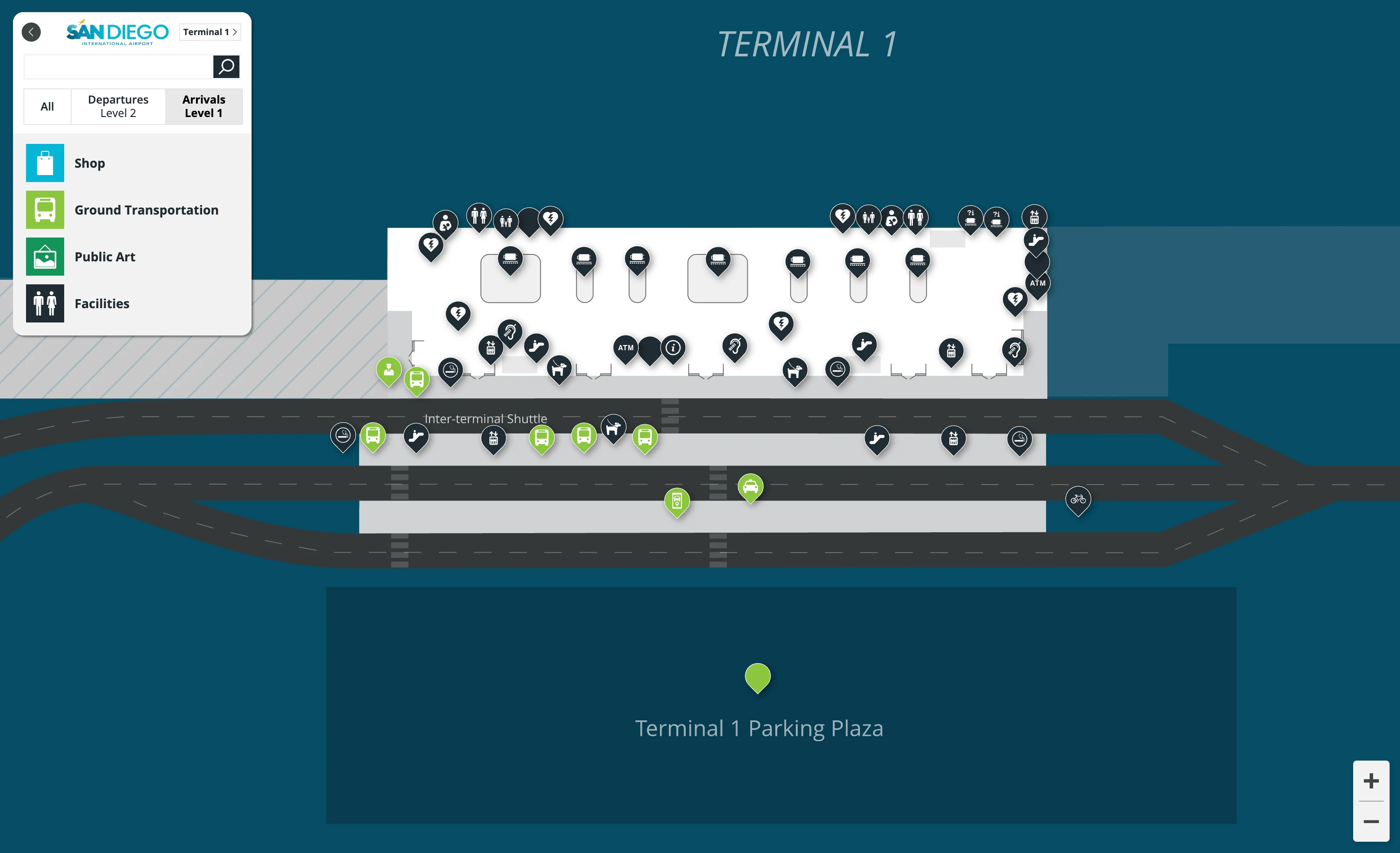
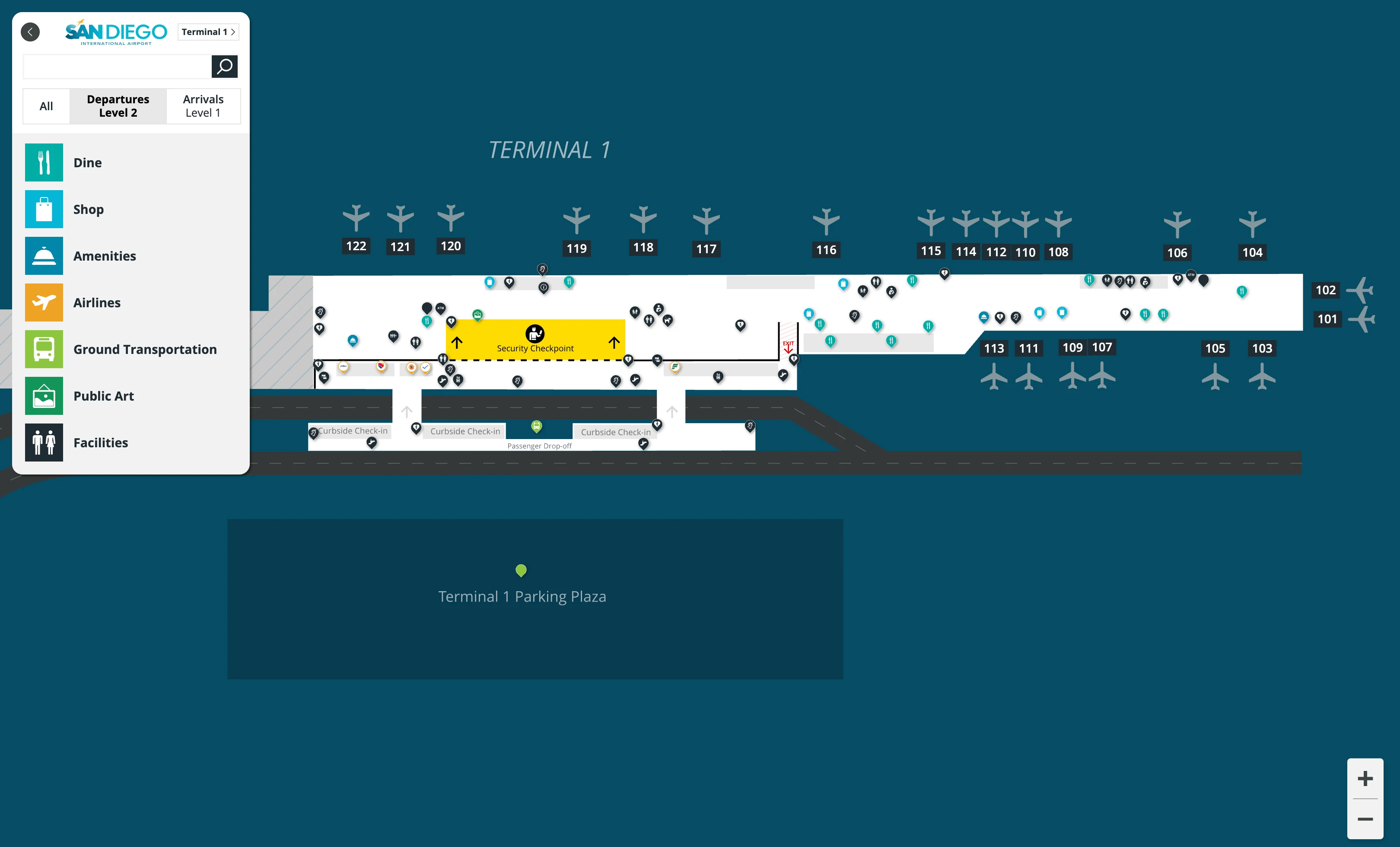
San Diego International Airport Terminal 1 is a vertically stacked, construction-era “island” within San Diego’s main airport hub, with Arrivals + Ground Transportation on Level 1 and Ticketing + TSA on Level 2. After security, the terminal fans into a large Marketplace/Food Hall, then runs as a straight, linear pier to Gates 101–119. Use the bright “Luminous Wave” glass wall as your cardinal cue: light/wave side leads toward gates; back toward the core leads to exits, restrooms, and elevators.
Map Table
| Zone | Connection | Walk Time |
|---|---|---|
| Level 2 Doors 1–3 | Check-in rows | 1–2 min |
| Level 2 Ticketing Hall | Consolidated TSA | 3–8 min |
| TSA exit | Marketplace / Food Hall | 1–2 min |
| Marketplace | Gates 118–119 | 6–10 min |
San Diego International Airport Terminal 1 Map Strategy
- Treat Terminal 1 like an island: plan transfers around the Terminal Loop Shuttle (Red Bus), not a Terminal 2 walk, and don’t follow west-side “dead wall” instincts toward fenced construction.
- Reduce funnel risk at the consolidated TSA: enter via Doors 1–3, move directly to the central checkpoint, and avoid drifting into the west-side overflow area by the oversized baggage drop and big digital boards.
- Use the Parking Plaza as your vertical shortcut: cross to the garage, take Core A/B elevators, then use the skybridge back to Level 2 when the internal elevator core is clogged with bags and carts.
- Pre-anchor relief points for crowding: aim for the Marketplace seating + Outdoor Patio right after security, then only commit to the long pier when your gate and boarding timing are confirmed.
2026 San Diego International Airport Terminal 1 Map + Printable PDF
Phase 1A operations remain centered on the New Terminal 1 facility, with adjacent demolition and Phase 1B construction continuing through the multi-year buildout. The printable 2026 map is most useful for locking in the vertical split (Level 1 pickups vs Level 2 departures), the single TSA “funnel,” and the long linear walk to the 101–119 gate pier without moving walkways.
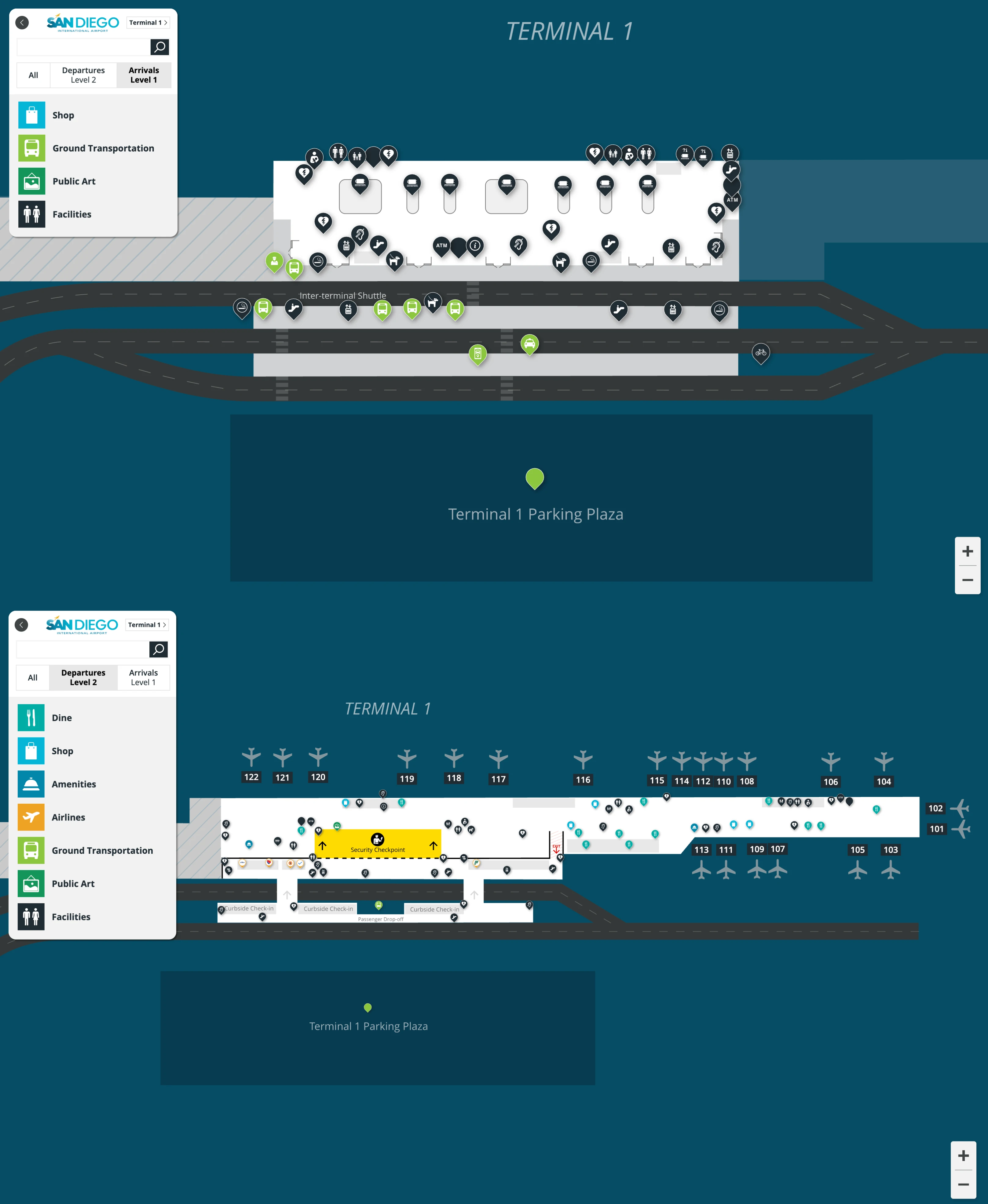
San Diego International Airport Terminal 1 Level 1 Arrivals Map 2025
San Diego International Airport Terminal 1 Level 2 Departures Map 2025
2026 San Diego International Airport Terminal 1 Map Guide
What is the exact walking distance (feet/meters) from the Terminal 1 rideshare pickup zone to the Terminal 1 TSA checkpoint entrance?
Walking distance is ~650 feet (198 meters) from the Terminal 1 app-based rideshare pickup zone (Level 1 Ground Transportation Plaza) to the Terminal 1 TSA checkpoint entrance (Level 2), because the route includes a plaza traverse, a vertical climb, and a skybridge crossing.
A reliable way to trace it on the map is: start at the “App-Based Rideshare” pickup area on the Ground Transportation Plaza, walk to the nearest Parking Plaza elevator core (Core A/Core B) or terminal-side escalators (~150 feet), go up to Level 2, cross the pedestrian skybridge back into the Level 2 Ticketing Hall (~150 feet), then continue across the hall to the consolidated TSA checkpoint entrance (~350 feet), using the central checkpoint frontage as your endpoint.
What is the exact curb-to-check-in walking distance from Terminal 1 Departures drop-off to the primary airline check-in row inside Terminal 1?
Walking distance is ~60–80 feet (18–24 meters) from the Level 2 Departures drop-off curb to the primary check-in row inside Terminal 1, because the counters face the main entry doors almost immediately.
Enter from the Elevated Departures Roadway on Level 2 and go through Doors 1, 2, or 3. The primary airline check-in row (especially the main Southwest counter line) is directly in front of those vestibules, with stanchions beginning within roughly 20 feet of the door threshold. The distance stays short even when it feels slow: curb access can bottleneck on the elevated roadway, but once you’re out of the vehicle and inside the doors, the counter front is essentially immediate.
Where is the exact physical location (landmark + side of hall) of the Terminal 1 TSA queue overflow area when the line backs up?
The TSA queue overflow forms in the west side of the Level 2 Ticketing Hall, adjacent to the Luminous Wave glass facade and the Oversized Baggage Drop, where the line has room to snake when the checkpoint “funnel” backs up.
When you’re facing the TSA checkpoint entrance, the line spills straight back from the center-rear checkpoint frontage and then doglegs left (west). Look under the large suspended digital directory/wayfinding boards: the queue typically builds beneath them in the open void between the check-in counter field and the front glass wall/skybridge area. In heavy surges, the line can extend toward—and even begin to crowd—the pedestrian bridge vestibules leading to the parking plaza.
What is the shortest indoor route from the Terminal 1 TSA exit to the closest high-capacity seating zone (largest seating cluster) airside?
Walking route is straight ahead ~150 feet (45 meters) from the TSA exit into the Marketplace/Food Hall, which is the closest high-capacity non-gate seating zone in Terminal 1.
Exit the checkpoint into the recomposure benches, then continue forward through the wide post-security corridor without turning. The corridor opens directly into the Central Atrium (Marketplace), where the largest seating clusters are concentrated around the dining tables, banquettes, and lounge-style seating. If you need overflow without hunting for gate seats, continue a few steps farther to the nearby Outdoor Patio access off the Marketplace, which functions as an additional high-capacity seating relief zone during peak crowding.
What is the exact location of the closest restrooms immediately after security in Terminal 1 (distance from TSA exit)?
Closest restrooms are ~75 feet (23 meters) from the TSA exit on the right (south) side of the main post-security corridor, immediately before you fully enter the Marketplace/Food Hall.
As you leave the recomposure benches and face toward the Marketplace, look to your right for the first restroom block set into the wall near the retail/duty-free-style storefront zone at the concourse entry. Use the corridor’s right-hand edge as your pathing cue; you should reach the restroom entrance within about a half-minute of normal walking, before you drift into the central seating and food lines.
What is the walking distance from the furthest common Terminal 1 gate cluster to the nearest restrooms (airside)?
Walking distance is ~250–300 feet (76–91 meters) from the furthest common gate cluster (Gates 118–119) to the nearest airside restrooms, which sit upstream near the Gate 114/115 block.
From the Gate 118–119 cul-de-sac seating, turn back toward the concourse “spine” (toward lower gate numbers) and stay tight to the main corridor until you reach the Gate 114/115 area. The restroom entrances are positioned as part of that mid-pier services block, so you’ll feel the corridor widen slightly as you approach it. The practical risk is timing: during simultaneous boarding at the south-end gates, the walk back is against a standing crowd that can choke the aisle, so go before the boarding groups pile into the corridor.
What is the exact walking distance from Terminal 1 baggage claim to the rental car shuttle stop serving the consolidated rental car facility?
Walking distance is ~200 feet (60 meters) from Terminal 1 baggage claim to the rental car shuttle stop, because the pickup is on a designated Ground Transportation Plaza island across the inner traffic lanes, not at the baggage-claim curb.
Exit the Level 1 Baggage Claim area near the doors aligned with the center carousels (often closest to Carousels 4–5), then take the marked pedestrian crosswalk across the private-vehicle lanes to the transportation islands. The rental car shuttle stop is on the middle island segment (commonly signed for “Rental Car Center Shuttle”), so your path is essentially: doors → crosswalk → island curb, with the crosswalk crossing as the only required “detour” element.
Where is the exact pickup point for the rental car shuttle relative to Terminal 1 baggage claim doors (door number/nearest landmark)?
Rental car shuttle pickup is on the Ground Transportation Plaza transportation island opposite Baggage Claim Doors 8 & 9, marked by “Rental Car Center Shuttle” pylons and blue/white curb markings.
From the Level 1 baggage claim exit doors, look straight across the inner roadway to the zoned islands; the rental car section is typically aligned with the parking plaza transit core area and is signed distinctly from hotel and other shuttle zones. Use the visual cue of the rental-car-specific vertical signs on the island (rather than the terminal curb) and position yourself at that signed segment before the bus arrives, since multiple shuttle modes share the same island footprint.
What is the shortest pedestrian route from Terminal 1 baggage claim to the taxi stand (no cross-traffic detours)?
Cross-traffic detours are mandatory, because the taxi stand is island-based in the Ground Transportation Plaza and cannot be reached directly from the baggage-claim curb without crossing the inner pickup lanes.
Exit Level 1 baggage claim through the central doors, then use the main marked pedestrian crosswalk to reach the Ground Transportation Plaza islands. After you reach the island area, continue along the island toward the west end to the taxi dispatch/queue position, using the taxi signage and the dispatch booth as your anchor. If you’re trying to minimize weaving, stay on the same crosswalk all the way to the island curb, then walk straight along the island edge until the taxi line begins.
What is the exact walking distance from Terminal 1 baggage claim to the rideshare pickup zone (including any ramps/elevators)?
Walking distance is ~300–400 feet (91–122 meters) from Terminal 1 baggage claim to the app-based rideshare pickup zone on Level 1, because the pickup is staged at the Ground Transportation Plaza/Parking Plaza interface rather than directly at the terminal curb.
Exit the Level 1 baggage claim doors, cross the inner lanes via the signed pedestrian crosswalk into the Ground Transportation Plaza, then follow “App-Based Rideshare (Uber/Lyft)” wayfinding toward the parking plaza-side staging area. The endpoint is the signed rideshare pickup zone within the Level 1 footprint of the Parking Plaza or the adjacent managed surface area, so the route is doors → crosswalk → plaza sidewalk → rideshare bays, with no required elevator if you remain on Level 1.
Where is the exact location of the closest post-security food option to the most congested gate hold area in Terminal 1?
Closest post-security food is in the Marketplace/Food Hall at the north end of the pier, about 50–150 feet from the central gate “belly” around Gates 106–112.
From the Gates 106–112 seating areas, walk back toward the concourse entry where the pier meets the central atrium. The highest-throughput, closest options cluster right at that transition point—Better Buzz Coffee, The Taco Stand, and Luna Grill sit in the Marketplace zone rather than deep in the gate corridor. Use the open, high-ceiling atrium and dense table seating as your landmark; once you hit that seating mass (and the patio access nearby), you’re at the nearest food concentration to the crowded mid-pier hold areas.
What is the shortest path from Terminal 1 gates to the nearest water bottle fill station (airside)?
Shortest path is to the nearest restroom core, because hydration stations are integrated into the wall immediately adjacent to restroom entrances throughout the airside pier.
From any gate seating area, walk toward the closest signed restroom block (common anchors are the Gate 105 area or the Gate 114/115 block). As you approach the restroom entrances, scan the adjacent wall panels right outside the doors for the recessed bottle-filler unit; it’s typically positioned as part of the same service “pod” as the restrooms rather than inside a concession. If the corridor is clogged near your gate, aiming for the Gate 114/115 services block is often easier than fighting the Marketplace crowd at the pier入口.
What is the shortest landside walking route between Terminal 1 and Terminal 2 (including the exact sidewalk segments used)?
No landside walking route exists, because the Terminal 1–Terminal 2 pedestrian sidewalk is closed and pedestrian access is prohibited through the Phase 1B demolition/construction zone.
The former connector path is blocked by fencing and “No Pedestrian Access” controls, creating a hard dead-end on the west side of Terminal 1. The only practical transfer is the Terminal Loop Shuttle (Red Bus) on the roadway loop, which replaces the old 10–15 minute walk. If you try to “self-route” on foot, you’ll be forced out toward perimeter sidewalks along North Harbor Drive and around construction barriers, which is not an authorized or traveler-friendly terminal-to-terminal connection with luggage.
Where is the exact location of the closest ADA-accessible elevator connecting Terminal 1 arrivals/ground level to ticketing/departures level?
Closest ADA-accessible elevators are in the central baggage claim core on Level 1, adjacent to the main escalators, and they run directly up to the Level 2 ticketing/TSA area.
From baggage claim, orient yourself toward the middle of the hall (the same zone where cross-flows converge between arrivals and departing passengers). The elevator bank sits next to the primary escalator set and functions as the terminal’s main vertical spine for wheelchairs, strollers, and luggage carts. If that core is jammed during an arrival bank, the fastest accessible alternative is to cross to the Parking Plaza and use the garage core elevators (Core A/Core B), then return via the pedestrian skybridge to Level 2.


