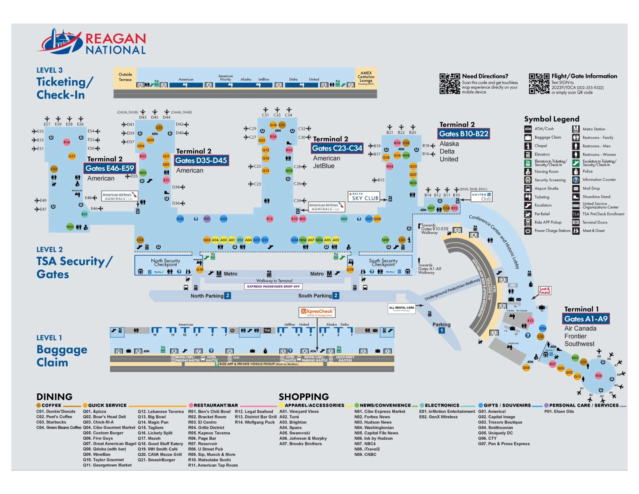
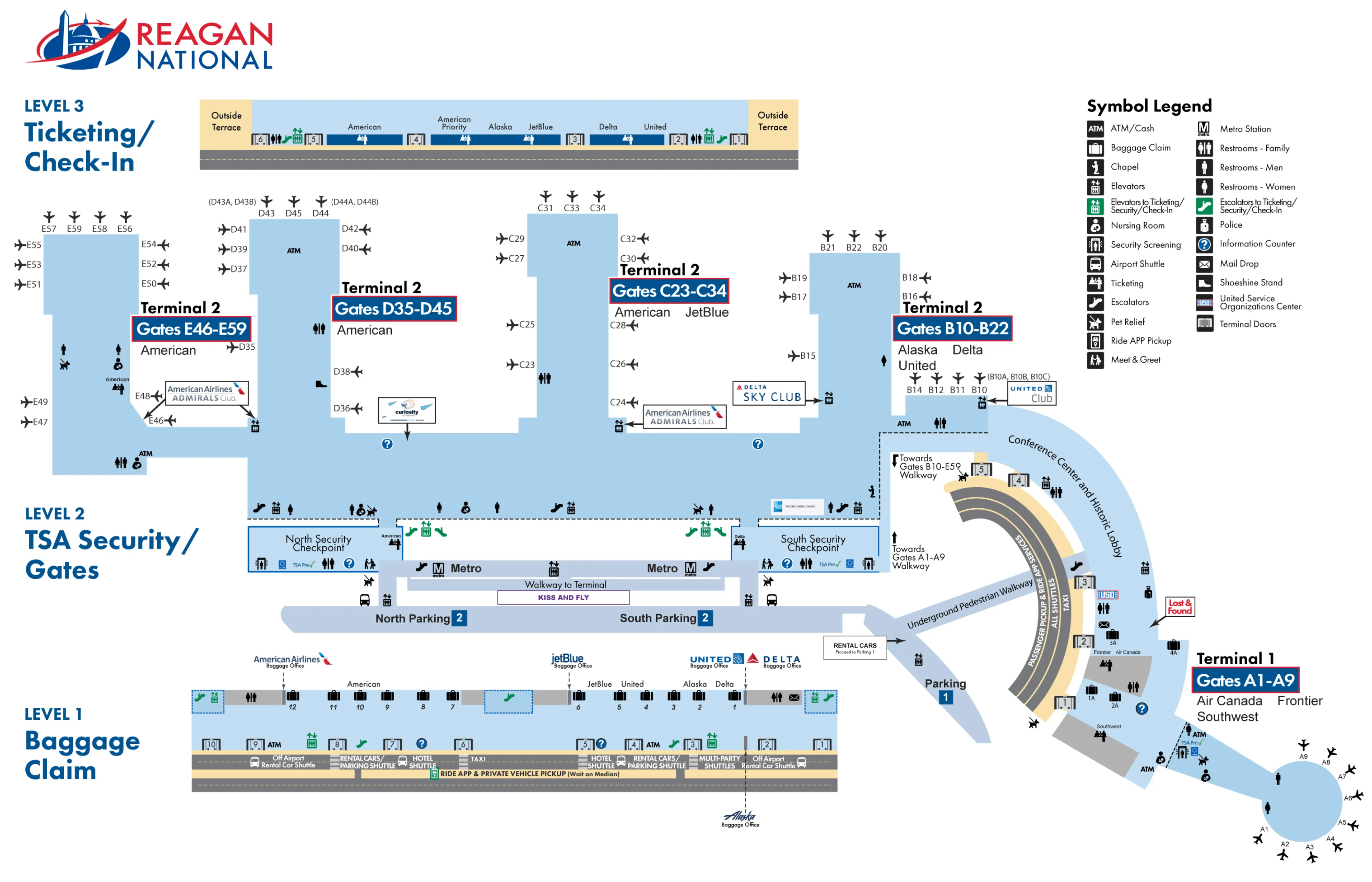
Ronald Reagan Washington National Airport Map (Most Up-To-Date)
Within the D.C. riverfront airport complex, the terminal footprint forms a shallow “J-curve” along the Potomac: Terminal 1 (A gates) at the short southern end and Terminal 2 stretching north to Concourses B–E, with Concourse E as the long-walk extension. Levels are stacked and decisive—Level 2 is the Metro/garage bridge + security level, while Level 1 is baggage claim and the split curb/median pickup system that drives most wrong-path mistakes.
Map Table
| Terminal | Key Airlines | Primary Function | Transfer Mode |
|---|---|---|---|
| Terminal 1 (A gates) | Southwest, Frontier | Historic rotunda, A1–A9 | Indoor connector from T2 Level 2 |
| Terminal 2 (B–E gates) | American, Delta, United, Alaska, JetBlue | Main terminal, National Hall | Metro/garage bridges Level 2 |
| Concourse E | American regional | Long pier, farthest walk | Moving walkways, full walk |
Ronald Reagan Washington National Airport Map Strategy
- Choose North vs South security by gate letter cluster, not by old “pier checkpoint” memory; the wrong entry still works, but it can cost a long lateral walk through National Hall.
- Stay on Level 2 from Metro/garage all the way to your checkpoint; dropping to Level 1 early triggers curb-road crossings and backtracking that feels irreversible under time pressure.
- After security, treat National Hall as a left/right decision: gate numbers rising toward D/E to the north, falling toward C/B to the south; check the trend immediately before you commit minutes the wrong way.
- For pickups, match door + level + crossing as one move: exit the correct baggage-claim door, use the aligned crosswalk, and land on the correct median/curb so your driver can actually reach you without a traffic-loop reset.
2025 Ronald Reagan Washington National Airport Map + Printable PDF
Project Journey’s centralized security layout is the operating reality in 2026: two big screening halls (North and South) feed directly into the secure-side National Hall. Expect most navigation to hinge on choosing the right checkpoint and staying on Level 2 until you’re committed to security or your gate direction. Printing a current terminal map is most useful for door/curb targeting on arrivals.
2026 Archive Ronald Reagan Washington National Airport Map Guide
What is the exact location of the Terminal 2 North security checkpoint entrance (level + nearest fixed landmark)?
The Terminal 2 North security checkpoint entrance is on Level 2, directly where the North Pedestrian Bridge from the Metro and Parking Garage 2 feeds into the terminal. It sits at the far north end of National Hall, aligned with the Concourse D/E side of Terminal 2.
From the Metro, stay on the platform level and follow “Terminal/North” to the enclosed glass bridge; that bridge lands straight into the North checkpoint atrium. On the terminal side, the fixed landmark is the National Hall north end junction near the Concourse D entrance, with American Airlines’ D/E gate cluster immediately beyond once you’re through screening.
What is the exact location of the Terminal 2 South security checkpoint entrance (level + nearest fixed landmark)?
The Terminal 2 South security checkpoint entrance is on Level 2, directly where the South Pedestrian Bridge from the Metro and Parking Garage 2 enters the terminal. It sits at the south end of National Hall, aligned with the Concourse B/C side of Terminal 2.
From the Metro, follow “Terminal/South” and stay on Level 2 across the enclosed bridge; you flow straight into the South checkpoint entrance without dropping to the street. On the terminal side, the fixed landmark is the National Hall south-end junction near the Concourse C entrance, positioned closest to the B10–B22 and C23–C34 gate clusters.
Where is the first decision point after exiting Terminal 2 security where you can clearly choose the correct pier toward B / C / D / E gates?
The first decision point is the immediate left-versus-right lateral turn onto the secure-side National Hall corridor as you exit the checkpoint recompose area. That turn determines whether you start walking toward higher gate numbers (D/E) or lower gate numbers (C/B).
From the North checkpoint exit, the clear choice is left (north) for Concourses D and the Concourse E connector, or right (south) toward the center for Concourse C and onward to Concourse B. From the South checkpoint exit, the clear choice flips: right (south) for Concourse B, or left (north) toward Concourse C and the rest of National Hall. Use the first overhead sign band you see in National Hall and confirm the gate-number trend before you commit.
What is the walking distance (meters) from the Terminal 2 North checkpoint exit to the start of the farthest gate corridor (the “long-walk” segment)?
Walking is about 240–250 meters from the Terminal 2 North checkpoint exit to the start of the farthest gate corridor leading into Concourse E’s long-walk segment. That “start” is effectively the base/neck where you enter the Concourse E connector before the long straight pier continues toward the highest E-gate numbers.
Measured from the North checkpoint exit, the path runs north along secure-side National Hall past the Concourse D area and into the Concourse E connector zone. The full walk to the farthest gate tip (E59) is much longer, but the “you’re committed to the long corridor now” moment happens once you hit the Concourse E entry/neck area where the moving-walkway connector transitions into the long pier.
Which two door numbers in Terminal 2 Arrivals/Baggage Claim open closest to the app-rideshare pickup median?
Doors 5 and 6 open closest to the app-rideshare pickup median in Terminal 2 Arrivals on Level 1. They sit in the middle of the designated app-based ride door cluster and align cleanly with the crosswalks to the median island.
- Use Level 1 (Baggage Claim/Arrivals) and walk toward the mid-terminal exits marked Door 5 or Door 6.
- Exit through Door 5 or Door 6, then use the zebra crosswalk directly in front of that door to reach the long median pickup island.
- Do not wait at the first curb by the glass doors; the rideshare pickup is across the inner roadway on the median, and drivers can’t reach the inner curb.
Where is the exact pedestrian crossing point from Terminal 2 rideshare doors to the rideshare pickup median (crosswalk/control point location)?
The pedestrian crossing point is the zebra-striped crosswalk directly aligned with the Terminal 2 Level 1 arrivals doors serving rideshare—Doors 4, 5, 6, and 7—crossing the inner roadway onto the long median pickup island. The “control point” is the painted crosswalk mouth at the curb cut immediately outside each of those doors.
Exit through Door 5 or Door 6, step onto the inner sidewalk, and use the crosswalk that starts straight ahead of your door (not a few yards left/right). You cross the two inner lanes (one-way flow from the building perspective) and step up onto the raised median where the app-based ride zone signs/zone numbers are posted for pickups.
What is the exact location of the “timed exit gates/doors” area between the terminal interior and the baggage claim / pre-security zone?
The “timed exit gates/doors” are the one-way automated glass exit barriers on Level 2 that separate the secure-side National Hall from the public, pre-security National Hall leading to baggage claim. They sit at the two main pier-cluster exits and are irreversible once you pass through.
| Exit zone | Level + exact placement | Nearest fixed landmark |
|---|---|---|
| North timed exit | Level 2, National Hall north end | Junction by Concourse D entrance and near the North Security Checkpoint |
| South/Central timed exit | Level 2, National Hall south-central | Junction by Concourse C entrance and near the South Security Checkpoint |
After you pass through either set of “No Re-entry” glass doors, the fastest continuation to baggage claim is the nearby escalator/elevator banks down to Level 1.
What is the narrowest choke-point corridor on the post-arrival path from gate exit flow → baggage claim (exact segment on the map)?
The narrowest choke-point is the Level 2 public-side escalator/elevator landing immediately after the one-way “No Re-entry” timed exit doors, where arriving gate flows compress before dropping to Level 1 baggage claim. This is the highest-penalty slow zone because people stop, regroup, and queue for the same vertical circulation.
On the map, it’s the short segment from the timed exit door line into the escalator bank vestibule at each main exit cluster. Use landmarks to find it: the north choke sits by the Concourse D junction near the North timed exit; the south/central choke sits by the Concourse C junction near the South timed exit. The effective width tightens at the top-of-escalator landing where retail edges and waiting passengers reduce the walking channel.
Where does the Metro-to-Terminal 2 walkway enter the terminal complex (exact entry point + level)?
The Metro-to-Terminal 2 walkway enters on Level 2 via the enclosed pedestrian bridge portals that land directly into the security-checkpoint atriums. There are two entry points: a North bridge that feeds the North Security Checkpoint area and a South bridge that feeds the South Security Checkpoint area.
Stay on the Metro platform level and follow “Terminal” signs to either the North or South glass bridge. The bridge doors deliver you into Terminal 2’s Level 2 circulation spine at the ends of National Hall, positioned as direct on-ramps into the checkpoint entrances rather than into the Level 1 arrivals roadway. Avoid taking Metro elevators down to street level unless you intentionally need the curb.
What is the shortest fully-indoor route from the Metro station connection to Terminal 1 (Southwest/Frontier) ticketing (exact connector/tunnel alignment)?
Walking fully indoors is shortest via the South Metro bridge into Terminal 2 Level 2, then the signed Level 2 connector through the Historic Lobby block into Terminal 1 ticketing. This route stays climate-controlled the entire way and avoids the curb-level road system.
From the Metro platform, take the South pedestrian bridge into Terminal 2 (Level 2). Immediately turn right (south) in the Level 2 corridor, pass the South Security Checkpoint area without entering, and follow “Terminal 1 / Historic Lobby” signs through the restored 1941 Historic Lobby section. Continue straight through the lobby connector and you’ll land directly at Terminal 1’s ticketing/check-in zone for Southwest/Frontier.
Which parking garage level connects via covered walkway into Terminal 2 (precise level + where it lands)?
Garage Level 2 connects via the covered pedestrian walkway into Terminal 2, landing on Terminal 2 Level 2 at the pedestrian-bridge entries that align with the security checkpoint atriums. This is the same “golden level” as the Metro platform and the checkpoint entrances.
From Garage 2, use Level 2 to access the enclosed bridge that passes toward the Metro station alignment and continues into the terminal. On the terminal side, the bridge deposits you at the ends of National Hall adjacent to the checkpoint approach zones (North bridge toward the North checkpoint; South bridge toward the South checkpoint), keeping you indoors and positioned to enter screening without dropping to the arrivals roadway.
Which elevator/escalator bank is the fastest vertical drop from the Terminal 2 garage walkway level down to Baggage Claim (exact bank location)?
The fastest vertical drop is the Terminal 2 atrium elevator bank immediately inside the terminal at the Level 2 pedestrian-bridge entry, not the garage elevators. This bank takes you down one level directly into the Level 1 baggage claim hall while staying fully indoors.
Enter Terminal 2 from the garage bridge on Level 2 and look for the main public elevator bank positioned right off the bridge arrival area in National Hall. Use that elevator (or the adjacent escalator bank when available) to descend to Level 1. The wrong-path trap is descending inside the garage first: that puts you outdoors at curb level and forces road/sidewalk crossings before you can reach baggage claim.
What is the exact vehicle approach path to reach Terminal 2 Arrivals without getting forced into the wrong loop (last decision fork/ramp location)?
Missing the arrivals split forces a full exit-and-return loop because the upper (Departures) deck can’t drop down to the lower (Arrivals) curb midstream. The last high-penalty decision is the roadway level split where signage separates “Arrivals / Baggage Claim” (down) from “Departures / Ticketing” (up).
| Decision point | What to do | What it prevents |
|---|---|---|
| Level split ramp (Arrivals vs Departures) | Follow “Arrivals / Baggage Claim,” stay on the lower-level lanes | Getting trapped on the upper deck with no drop-down |
| Terminal split (T1 vs T2) | After committing to Arrivals, continue past the early Terminal 1 spur and keep right for Terminal 2 | Accidental diversion into the Terminal 1 circle |
| Curb choice at T2 arrivals frontage | Personal pickup: keep right for inner curb; app/commercial: keep left for outer/median lanes | Waiting at a curb your vehicle type can’t access |
As soon as you see the first big “Arrivals” ramp decision, commit down and stay down.
What is the exact vehicle approach path to reach Terminal 1 curb without overshooting into Terminal 2 circulation (last decision fork/ramp location)?
Terminal 1 access depends on taking the first right-hand spur immediately after entering the airport roadway, because there’s no later crossover from the Terminal 2 lanes back to Terminal 1. The last decision fork is the immediate “Terminal 1” right turn off the main approach before the roadway commits you into the Terminal 2 complex.
Stay in the far-right lane as you enter airport grounds and take the first exit signed for “Terminal 1” (historic terminal). That ramp feeds directly into the Terminal 1 traffic circle/rotunda, where the curb runs along the right side of the circle. If you pass into the long Terminal 2 frontage (or see the main Terminal 2 building dominating the roadway), you’ve overshot and must continue through, exit, and use the return-to-airport loop to try again.
Archive Ronald Reagan Washington National Airport Map
Below are all historical map versions for Ronald Reagan Washington National Airport. Each year includes the official map available for that period, presented as both WebP and PDF.
2022 Ronald Reagan Washington National Airport Map