Nice-Côte d’Azur Airport Terminal 2 Map (Most Up-To-Date)
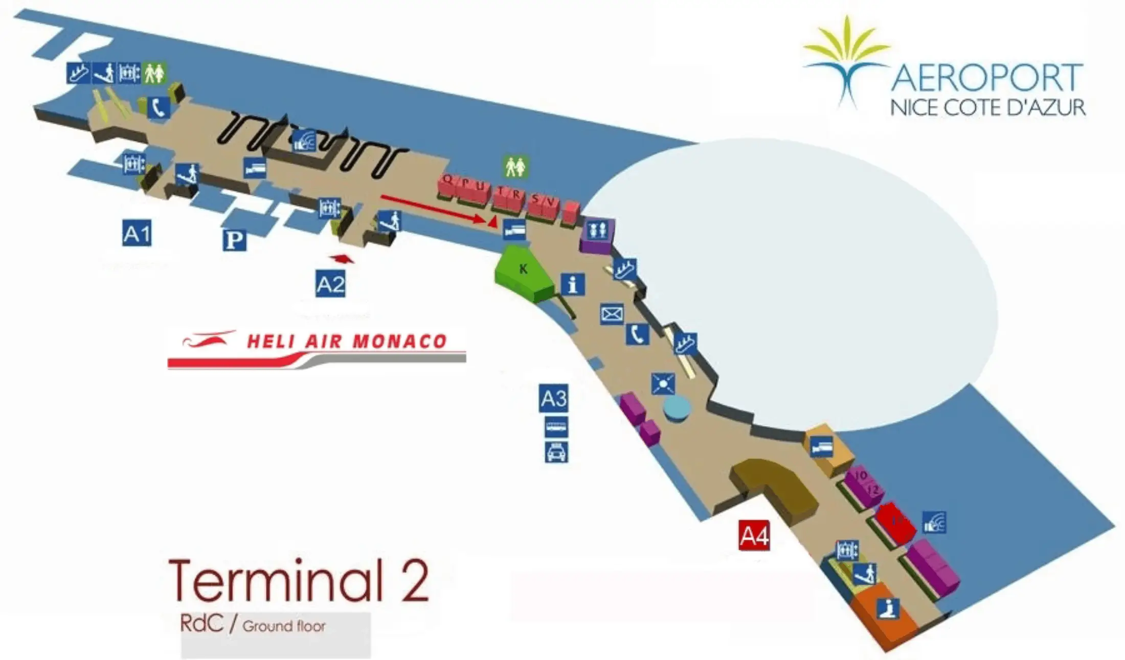
Nice-Côte d’Azur Terminal 2 is a compact “dumb-bell” layout: a central Level 1 departures spine feeding Zone A (Schengen retail/concourse) and a linear Zone B pier (Non-Schengen B-gates) that only opens through a single passport-control funnel. Arrivals and ground transport sit on the ground floor along the forecourt. Within the Nice airport complex, the terminal’s biggest time risk is not distance but forced choke points that hit after you think you’re already “airside.”
Map Table
| Level | Gate Zones | Primary Flows | Hard Chokepoint |
|---|---|---|---|
| Ground (Arrivals) | A2–A3 frontage | Tram, taxi, rideshare, P5 access | Forecourt lane crossings |
| Level 1 (Departures) | Zone A concourse | Security exit, retail, lounge access | Duty-free corridor crowding |
| Level 1 (International Pier) | B30–B32 distal | Non-Schengen departures | Police aux Frontières passport control gateway |
| Lower level / mezzanine | Remote stands | Bus-gate boarding | Downstairs holding pen |
Nice-Côte d’Azur Airport Terminal 2 Map Strategy
- Treat the Police aux Frontières passport-control gateway as the single forced funnel to every B-gate; the last safe “turn-back” is the queue entrance before the booths/e-gates.
- Budget the worst-case walk as security exit → Zone A traverse → passport-control gateway → B30–B32 tip: 10–12 minutes walking, then add a 30–60 minute buffer for border latency when banks of flights stack.
- Assume late-stage friction at remote stands: bus-gate holding areas sit down from the Level 1 departures concourse, so stay upstairs for amenities until boarding, then allow extra time for the descent + scan + bus queue.
- Make landside irreversible split points unmissable: Dépose-Minute uses the upper ramp off Boulevard Jacqueline Auriol Supérieur (wrong lane can force paid parking), rental returns require the P5 pedestrian path + zebra crossing + up to Level 1, and the free-tram boundary ends at Grand-Arénas where the first validator/ticket risk begins.
2026 Nice-Côte d’Azur Airport Terminal 2 Map + Printable PDF
Terminal 2 continues to operate under peak-capacity pressure in 2026, with the Non-Schengen interface acting as the critical-path constraint for “time-to-gate.” Border processing changes tied to the European Entry/Exit System (EES) make queue behavior at the Zone B gateway the variable that matters most. Plan the map around irreversible boundaries (passport control, bus-gate descent, tram free-zone end) rather than straight-line walking distance.
2026 Nice-Côte d’Azur Airport Terminal 2 Map Guide
What is the exact location (landmark + adjacent gate numbers) of the single funnel point that B-gates are forced through inside Terminal 2?
The Police aux Frontières passport control checkpoint on Level 1 is the single forced funnel to the B-gates. It sits at the end of the Zone A (Schengen) retail plaza, where the main departures concourse narrows into the controlled entry for the International Pier. You reach it by walking straight through the duty-free corridor after central security; it is the only doorway-like partition separating Zone A from Zone B.
| Landmark reference point | Adjacent gate context | What it controls |
|---|---|---|
| End of Zone A retail/duty-free on Level 1 | Before the Zone B pier leading toward B-gates (including the far B30–B32 cluster) | Only access into the B-gate corridor via PAF booths/e-gates |
What is the walking time (minutes) from the main Terminal 2 security exit to the furthest B-gate cluster (the worst-case walk)?
Walking takes about 10–12 minutes from the main Terminal 2 security exit to the furthest B-gate cluster (B30–B32), excluding any passport-control queue. From the security exit you flow into Zone A retail, cross the duty-free corridors to the Police aux Frontières checkpoint, then continue down the International Pier to the distal B30–B32 tip. The walk itself is manageable; the uncontrollable variable is the passport-control funnel, which can add 2–45+ minutes right before you enter the B-gate corridor.
Where is the bus-gate waiting area located in Terminal 2, relative to the main departures concourse (exact corridor/turn and level)?
The bus-gate waiting area is on a lower level below the Level 1 departures concourse, reached by descending via the stairwells/escalators signed for the remote-stand gate cluster. From the main departures spine on Level 1, follow the gate-range signage toward the pier, then take the dedicated down-route (stairs/escalator) that drops you into a holding-pen area with limited seating and minimal services. Staying on Level 1 until boarding is called avoids getting stuck early in the downstairs pen, but you still need to allow a few minutes for the descent and the scan queue before the bus loads.
What is the shortest pedestrian route from Terminal 2 rental car return to the Terminal 2 departures doors (exact crossings + level changes)?
Walking takes about 5–8 minutes from the Terminal 2 rental car return to the Terminal 2 departures doors, with one roadway crossing and one level change. Exit the Car Rental Center on the side facing Terminal 2, follow the protected pedestrian path through/along Car Park P5, then use the zebra crossing over the terminal access road to enter Terminal 2 at the ground-floor Arrivals frontage near Doors A2–A3. Inside the building, take the nearest elevator or escalator up from Arrivals (ground level) to Level 1 Departures, then exit onto the elevated forecourt doors.
Where exactly is the Terminal 2 “Dépose-Minute” vehicle entry (which approach road/turn-in), and what curbside segment does it feed?
The Terminal 2 Dépose-Minute entry is the upper-ramp turn-in off Boulevard Jacqueline Auriol Supérieur that climbs to the Level 1 Departures forecourt. Approaching Terminal 2, stay in the right/upper lanes signed for “Dépose-Minute / Departures,” not the lower/left lanes that peel toward Arrivals, Parking P5/P6, and the Car Rental Center. That ramp feeds the elevated curb directly in front of the Departures doors on Level 1, where unloading runs under a strict short free-time window before charges apply.
What is the precise map point where the free tram segment ends (Airport terminals ↔ Grand Arénas), i.e., the first validator/ticket boundary you must not pass without a ticket?
Grand-Arénas station is the precise endpoint of the free tram segment for the airport zone. Staying on the tram past Grand-Arénas toward the next stop (Parc Phoenix) is the first point where you must have a validated ticket, because that’s where the airport concession ends and the city network begins. Treat Grand-Arénas as the hard boundary: if you continue beyond it without validation, you’ve crossed into the enforcement zone where fare checks and fines are most likely.
Where is passport control positioned for non-Schengen departures in Terminal 2 (before/after security, and which corridor leads into it)?
Passport control for non-Schengen departures is on Level 1 after the main security checkpoint, at the end of the Zone A (Schengen) retail/duty-free corridor. After you clear central security you enter the Zone A departures concourse, then walk through the retail spine until the space narrows into the Police aux Frontières checkpoint that physically separates Zone A from the Zone B International Pier. Once you pass that control point, you are committed to the B-gate side; the B-gate corridor continues forward toward the far B30–B32 cluster.
What is the shortest walking route from Terminal 2 Arrivals to Terminal 2 Pick-Up / rideshare meeting area (exact doors and curb zone)?
Walking takes about 2 minutes to reach the most reliable rideshare pick-up, which is typically the P5 Car Park meeting area, from Terminal 2 Arrivals. Exit the Arrivals hall via Doors A2 or A3, then cross the inner forecourt traffic lane toward the parking side rather than waiting on the immediate curb outside the glass doors. Follow the forecourt signage toward Car Park P5 / short-stay parking, which keeps you out of the restricted curb zone where taxis and official vehicles dominate and where ride-app drivers are least able to stop.
Where is the closest re-routing “escape point” after entering the wrong Terminal 2 gate corridor (the last place you can turn back without a long backtrack)?
The queue entrance immediately before the Police aux Frontières passport-control booths/e-gates is the last self-service escape point. If you realize you’re heading into the Non-Schengen B-gate corridor by mistake, step out of the passport-control queue area and return into the Zone A retail/departures concourse while you are still outside the controlled processing line. Once your document is scanned/stamped and you pass the control barrier, returning to Zone A is no longer a simple turn-back and typically requires border police intervention.
Archive Nice-Côte d’Azur Airport Terminal 2 Map
Below are all historical map versions for Nice-Côte d’Azur Airport. Each year includes the official map available for that period, presented as both WebP and PDF.
2011 Nice-Côte d’Azur Airport Terminal 2 Map