Istanbul Atatürk Airport Map (Most Up-To-Date)
Atatürk Airport’s overall footprint was a compact, side-by-side terminal complex with a long, linear airside edge: the Domestic building on the east, the International building centered/west, and apron space stretching north–south toward the Sea of Marmara. Within Istanbul’s air-travel network—now oriented around the new Istanbul mega-hub—the defining “shape” was a tight landside core feeding long pier walks, plus a hidden ground-level bus-gate layer that made transfer timing structurally unpredictable.
Map Table
| Terminal | Key Airlines | Primary Function | Transfer Mode |
|---|---|---|---|
| Terminal 1 | Turkish Airlines (domestic) | domestic processing | inter-terminal connector |
| Terminal 2 | Turkish Airlines + partners | international processing | transfer-security → duty-free hub |
| Remote stands / bus gates | mixed carriers | overflow gate capacity | apron bus + ground-level holding |
| General aviation zone | government / private | non-commercial operations | restricted-access landside |
Atatürk Airport Map Strategy
- Treat bus gates as the default risk: remote-stand arrivals and departures add a hidden ground-level layer plus holding-area dwell time that can erase your buffer before you even start walking.
- Treat transfer-security placement as a hard checkpoint: once you commit into the queue corridor, rerouting options collapse, so confirm you’re in the transfers flow before you enter any “snake” lines.
- Treat long walks as an outcome you must plan for: worst-case connections span pier-to-pier distances that feel safe on a ticket but become unsafe once queues, slalom crowding, and level changes stack up.
- Treat international-to-domestic movement as a friction event: the connector corridor and grade changes (“uphill walk” reports) make wrong turns and slow luggage-hauls more likely than the map distance suggests.
2026 Istanbul Atatürk Airport Map + Printable PDF
Commercial passenger traffic remains closed at Atatürk Airport in 2026, with activity centered on government, maintenance, and general aviation functions. Printable maps are therefore most useful as a legacy-layout reference: the historic passenger experience depended on inter-terminal connectors, a transfer-security bottleneck on the arrivals level, and a ground-level bus-gate system that could add large, invisible time penalties to “normal” connection windows.
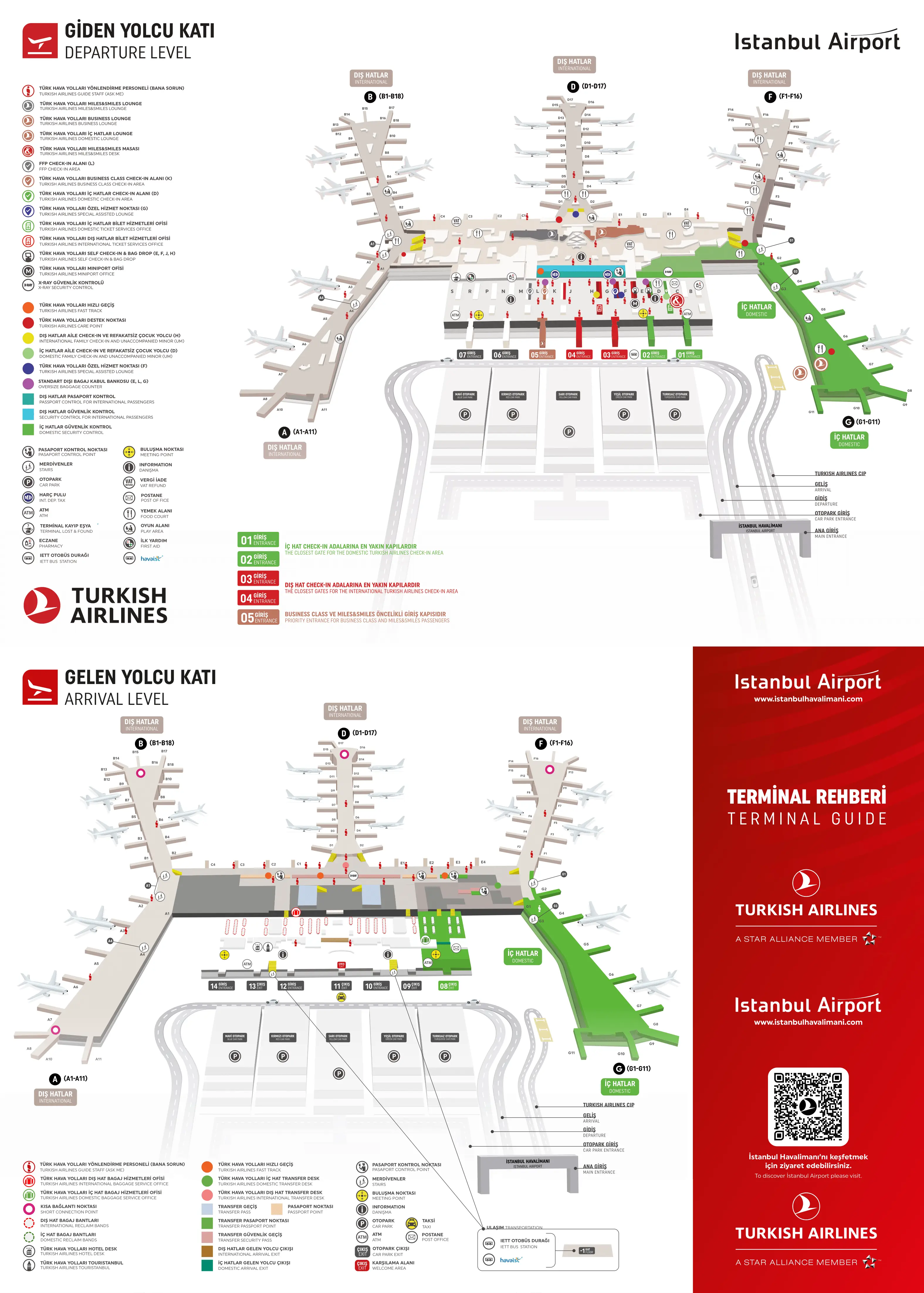
Istanbul Atatürk Airport Departure Map 2025
Istanbul Atatürk Airport Arrival Map 2025

2026 İstanbul Atatürk Airport Map Guide
What is the exact walking route from the Transfer Security checkpoint to the nearest Departures flight-information board (fastest path, no detours)?
Walking takes about 90–120 seconds from the Transfer Security exit to the nearest main Departures flight-information board, assuming you move straight through the duty-free “Mall” without browsing detours.
| Step | Route (fastest path) | Landmark anchor |
|---|---|---|
| 1 | Exit the Transfer Security x-ray area on the arrivals level | end of x-ray machines / stanchions |
| 2 | Take the first escalators up one level to Departures | escalator bank immediately after security exit |
| 3 | Walk straight off the escalators into the central atrium flow | back side of the main duty-free complex |
| 4 | Cut through the duty-free island maze using the widest central aisle | perfume/cosmetics islands that force a slight curve |
| 5 | Stop directly under the large multi-panel board in the center of the atrium | suspended central FIDS board just past the retail choke point |
Where is the Transfer Desk located relative to the Transfer Security checkpoint (same level vs different level, and which corridor connects them)?
The Transfer Desk sat on the arrivals level immediately before the Transfer Security entrance, so it was on the same level and in the same pre-security corridor flow.
Transfer desks lined the right-hand wall of the widened arrivals corridor as passengers approached the central processing block. The key landmark was the “last safe stop” positioning: the desks appeared just upstream of the transfer-security queue mouth, before the corridor geometry and crowd pull started to drift toward the passport-control exit lanes. If you walked past the transfer-security entrance looking for information or toilets, you risked being pulled toward the passport-control boundary instead of staying in the transfers channel.
What is the map-verified path from an arrival bus gate to the main international terminal concourse (including the first decision point where people pick the wrong corridor)?
The first dealbreaker is the corridor split at the top of the arrival escalator: taking the left/straight flow pulls you toward Passport Control and can commit you away from Transfers.
Arriving buses offload on the ground level at a bus injection intake beneath the central concourse root. Walk through the automatic doors into the low-ceiling intake hall, then take the escalators up to the arrivals corridor level. At the top, the corridor splits: the wide left/straight lane runs toward Passport Control and baggage/exit flows, while the narrower right turn leads into International Transfer Security. After turning into the transfers side, join the security queue, clear x-ray, then take the next escalators up to the departures level, emerging into the duty-free “Mall” that functions as the main international concourse hub.
What is the maximum walking time (map-measured) from the furthest typical arrival gate zone to the furthest typical departure gate zone inside the international terminal?
Walking takes about 20 minutes in a worst-case pier-to-pier scenario inside the international terminal, excluding any security or queue time.
The longest “tail-to-tail” path ran from the far end of the western pier (commonly referenced as the Gate 201 end) to the far end of the eastern pier (commonly referenced as the Gate 226 end), with the central hub (transfer-security and the duty-free atrium) in between. The walk breaks into two long legs of roughly 8–10 minutes each with crowd slalom and moving-walkway variability, plus level changes via escalators at the hub. This is why tight connections failed: the walking component could be survivable, but the transfer-security bottleneck and gate-area screening could stack on top of it fast.
Where are the bus-gate waiting lounges/holding areas located on the departures side (and what is the closest landmark you reach right before entering them)?
The bus-gate waiting lounges were on the ground level below the departures concourse, and you had to commit to a down-escalator or stairwell before you could see them.
The departures-side holding areas sat beneath the main concourse as clustered “pens” for remote-stand boarding (commonly described as 300-series and other remote-designated gates). The closest reliable pre-entry landmark was the coffee/café zone near the start of the main pier—often remembered as a Starbucks/café area—where overhead signs pointed down with gate ranges and a down arrow (for example, “Gates 301–312”). After passing that landmark, the defining step was the descent: once you went down, you were in the low-ceiling bus-gate environment and no longer had easy visual confirmation from the main concourse.
What is the exact indoor route from International Arrivals to the Domestic Departures check-in/security entrance (the path people describe as an ‘uphill walk’)?
Passport control is the dealbreaker: you had to clear Passport Control into Turkey before you could reach Domestic Departures, so this was not a pure airside transfer.
From International Arrivals, follow the exit flow to Passport Control and enter Turkey, then proceed to baggage claim if required (bags not through-checked). Instead of heading out to the arrivals curb, follow “Domestic Transfers” or “Domestic Terminal” signage toward the inter-terminal connector. Enter the long enclosed connector corridor linking the international building to the domestic building; the “uphill” feel came from extended sloping ramps and grade changes between the two structures, especially when travelators were inactive. The corridor eventually deposits you into the Domestic Departures check-in hall, where the security entrance sits at the departures-processing edge of that hall.
Where is the passport control boundary located in relation to the transfer corridor (the specific point where a wrong turn forces you landside)?
The passport-control boundary sat directly beside the transfer corridor on the arrivals level, and entering the passport-control “snake” queue was the point of no return that effectively forced a landside outcome.
On the arrivals corridor level, Passport Control booths spanned most of the rear processing wall, while the Transfers channel ran as a narrow bypass lane along the extreme edge of that same zone. The boundary itself was often just belts or low glass partitions separating the two flows. The practical wrong-turn trigger was the Visa-on-Arrival desk area: if you passed the visa desks and stepped into the stanchioned passport queue, you were caged in by barriers and switching back to Transfers meant physically escaping the queue against the crowd.
Where are the secondary screening / extra x-ray points placed between the public departures hall and the gate concourse (which chokepoint is most likely to bottleneck)?
Secondary screening most often appeared at the entrance to specific gate boarding lounges, and those pop-up checkpoints could choke the pier corridor even after you were already “at the gates.”
Beyond the main departure processing, flights with heightened screening requirements (commonly cited for routes such as the USA, UK, and Israel) added x-ray and/or ETD stations right at the gate-zone threshold. The equipment and queue were frequently placed in-line with the pier walkway, narrowing the corridor so that one gate’s screening line spilled into through-traffic. The most likely bottleneck was any gate with a secondary checkpoint positioned on the central spine pier: when the queue extended into the main concourse path, it slowed passengers trying to pass by to neighboring gates, turning a single flight’s screening into a corridor-wide blockage.
From the transfer-security exit, what is the shortest route to the closest restrooms (so travelers can decide whether they have time before running to the gate)?
Restrooms are immediately adjacent to the transfer-security escalator landing on the departures level, typically tucked left and right behind the first duty-free display row.
Clear transfer security, take the escalators up, and stop as soon as you step off at the top. The nearest toilets were placed right beside that escalator arrival zone, but they were often visually obscured by the first retail islands in the duty-free “Mall.” If those are overcrowded, the fastest “still-short” alternative was to walk roughly 50 meters straight into the central atrium and peel into the start of the first pier corridor (A/B side), where the first pier restrooms tended to be less saturated than the transfer-dump-valve toilets by the escalators.
Where are the closest seating-dense zones immediately after the transfer-security exit (to reduce standing-room-only stress near gates)?
The most seating-dense option immediately after transfer security was the food court above the central atrium, reached by taking the next escalators up to the mezzanine level.
The departures-level duty-free “Mall” right after the transfer-security escalators was commerce-first and tended to have very little free public seating, creating a standing-room-only feel. For reliable seating without committing far down a pier, follow the central atrium sightline and take the escalators up to the food court/mezzanine, which concentrates tables and chairs. The other seating-heavy fallback was to keep moving to the start of a gate pier and use gate-area seating rows, but that strategy carries risk if your gate later posts on the opposite wing and forces backtracking.
What is the map-verified shortest route from the domestic-to-international transfer entry to the nearest airline lounge cluster (if present in that terminal layout)?
Walking takes roughly 2–4 minutes from the international departures entry point to the nearest major lounge cluster, anchored by the Turkish Airlines CIP Lounge area near the Concourse A/B side of the main atrium.
After arriving from the domestic side and entering the international departures environment, orient to the central atrium/duty-free hub as your reference point. From the atrium-facing position, turn left toward the Concourse A/B direction and continue along the concourse edge for about 100–150 meters. The lounge entrance zone sits on that left-side run, positioned as a prominent landmark near the Concourse A/B access rather than deep inside a pier. There was no direct “domestic airside” shortcut into the lounge area; you had to enter the main international departures concourse first and then walk laterally to the lounge frontage.
Where is the first reliable gate-number display you can reach after clearing the transfer process (the earliest point you can confirm a gate without backtracking)?
The first reliable gate-number display was the large central flight-information board suspended in the main atrium immediately after you emerge from the transfer-security escalators into the duty-free hub.
Clear transfer security, ride the escalators up to the departures level, and push straight through the duty-free island maze without committing down any pier. The earliest low-regret confirmation point is directly beneath that central multi-panel board, positioned in the middle of the “Mall”/atrium zone just past the main retail choke. Smaller scattered screens around the concourse were less reliable for first-time gate assignment and often lagged with messages like “Wait in Lounge,” so walking deep into a pier before checking the central board was the classic backtracking trap.