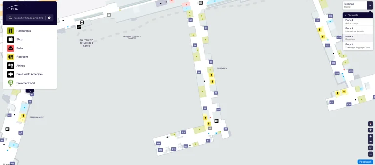
Dothan Airport Terminal Map
Location: Dothan, Alabama
Looking for the latest details on Dothan Airport Terminal Map?
Dothan Regional Airport (DHN) is a public airport located 7 miles northwest of Dothan, Alabama. It offers commercial flights to Atlanta via Delta Connection, features two runways, and provides amenities such as car rentals, a café, and a gift shop.
You’ve come to the right place! Whether you’re grabbing a quick snack at the SkyChef Café or looking for a comfortable place to relax before your flight, this map has it all. Don’t miss the cozy seating area near Gate 3, perfect for unwinding.
With up-to-date navigation, you’ll have a smooth journey through the terminal, so you can focus on the fun ahead.
DHN Airport Terminal Overview Map 2024

FAQ
How early should I arrive at Dothan airport?
Passengers should arrive at Dothan Regional Airport at least 1 hour before their scheduled domestic flight departure time. This allows sufficient time for check-in, security screening, and boarding procedures.
How big is Dothan Airport?
Dothan Regional Airport covers an area of 1,150 acres. It features two asphalt runways: the primary runway (14/32) is 8,499 feet long and 150 feet wide, while the secondary runway (18/36) is 5,498 feet long and 100 feet wide.
What airlines use Dothan airport?
Delta Connection is currently the only commercial airline operating at Dothan Regional Airport. They provide twice-daily flights to Hartsfield-Jackson Atlanta International Airport (ATL) using CRJ-700 and CRJ-900 aircraft.
What airport do you fly into for Dothan, Alabama?
Dothan Regional Airport (IATA: DHN, ICAO: KDHN, FAA LID: DHN) is the primary airport serving Dothan, Alabama. It is located approximately 7 miles northwest of the city center in Dale County.