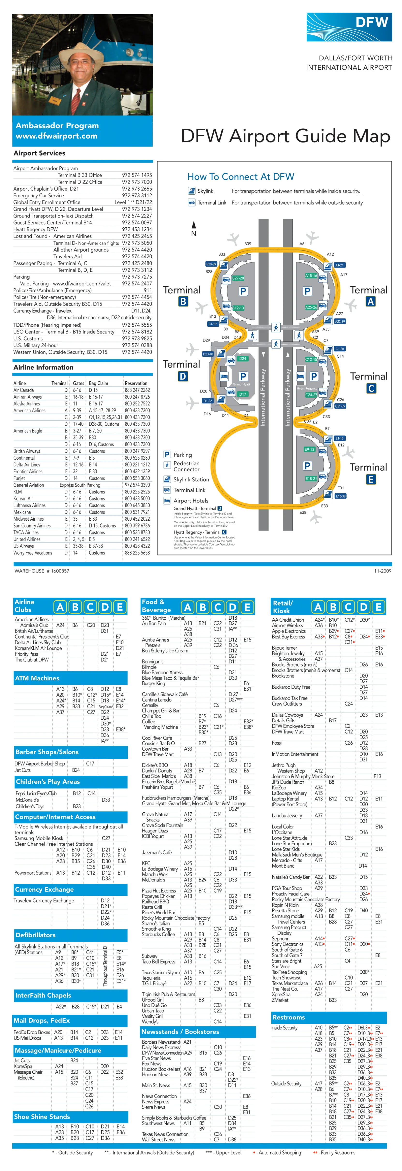
Dallas Fort Worth International Airport Map (Most Up-To-Date)
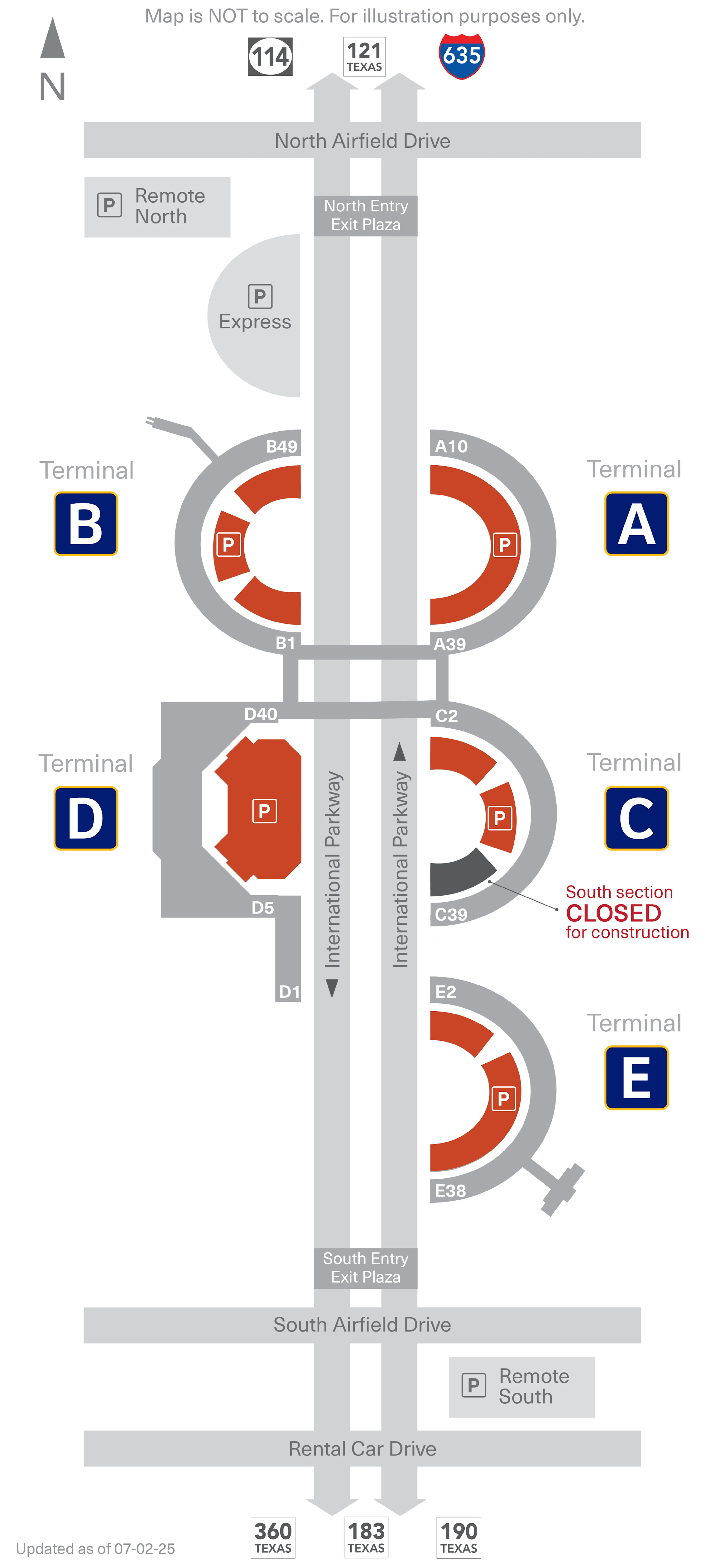
Dallas Fort Worth International Airport is a five-terminal, semi-circular complex (A–E) wrapped around International Parkway, with terminals forming a loose ring around the central roadway. The secure side is stitched together by the elevated Skylink loops, while the public side is organized by curb levels and the Terminal Link shuttle stops. Within North Texas’s main airport grounds, the biggest orientation cue is “airside train vs landside curb” before you commit to stairs, doors, or elevators.
Map Table
| Terminal | Key Airlines | Primary Function | Transfer Mode |
|---|---|---|---|
| Terminal A | American Airlines | Domestic | Skylink (A-North, A-South), walkways to B/C, Terminal Link (Upper) |
| Terminal B | American Eagle, regional | Domestic, regional | Skylink (2 stations), walkway to D, TEXRail (B43), Terminal Link (Upper) |
| Terminal C | American Airlines | Domestic, high-density | Skylink (2 stations), walkways to A/D, Terminal Link (Upper) |
| Terminal D | International carriers, American | International, CBP | Skylink (D-North, D-South), Terminal Link (Lower), CBP exit Level 1 |
| Terminal E | Delta, United, Southwest | Domestic, satellite gates | Skylink (E-North, E-South), E Satellite tunnel, Terminal Link (Upper) |
Dallas Fort Worth International Airport Map Strategy
- Stay post-security whenever possible: Skylink beats any curbside transfer, and exiting landside forces a full TSA reset.
- Choose Skylink by direction, not just the station: the wrong loop can add multiple terminal stops and 10–15+ minutes.
- Treat Terminal E as non-walkable airside: plan Skylink for any C/D/B ↔ E move, plus extra time for the E Satellite tunnel.
- Remember Terminal D’s level inversion: Terminal Link pickups on the lower level at D, while rideshare remains upper-level curb.
2026 Dallas Fort Worth International Airport Map + Printable PDF
In 2026, DFW’s core navigation logic remains stable: Skylink is the only fast post-security inter-terminal connector, and Terminal Link is the primary landside fallback when you’ve exited security or Skylink is down. Terminal E still functions as the “island” terminal (no airside walkways to other terminals), and Terminal D still has the key curb-level exception for Terminal Link pickup.
2026 San Francisco International Airport Map Guide
Where are the Skylink stations located inside each terminal (A/B/C/D/E) relative to the main gate clusters (north/south/center concourses)?
Skylink stations at DFW sit mid-concourse and split each terminal’s gates into two walk zones, with “North” stations serving the lower-numbered gate clusters and “South” stations serving the higher-numbered clusters (Terminal B’s gate numbering runs opposite the intuitive north/south feel).
| Terminal | Station node | Relative position | Nearest gate cluster served |
|---|---|---|---|
| A | A-North | between main concourse bends | A1–A20 (near A13–A16) |
| A | A-South | south/upper-number gate side | A21–A39 (near A29–A34) |
| B | B-North | south/central arc | B1–B14 (near B9–B14) |
| B | B-South | geographic north end | B26–B49 (near B28–B43) |
| C | C-North | north/low-number side | C1–C19 (near C8–C12) |
| C | C-South | south/high-number side | C20–C39 (near C27–C35) |
| D | D-North | north/low-number side | D1–D22 (near D11–D20) |
| D | D-South | south/high-number side | D23–D40 (near D24–D34) |
| E | E-North | north/low-number side | E2–E18 (near E8–E11) |
| E | E-South | south/high-number side | E20–E38 (near E31–E34) |
What is the fastest post-security path from Terminal A to Terminal D using Skylink (station-to-station, direction, intermediate stops)?
The fastest post-security A → D transfer is Skylink toward Terminals B & D (outer/counter-clockwise direction on the loop logic), because it reaches D in two terminal hops instead of routing through C and E.
| Step | Node → Connector → Node | Direction cue | Intermediate stops |
|---|---|---|---|
| 1 | Terminal A gates → Skylink Station A-South (between A29/A34) | follow “Skylink” to south/high-number gates | none |
| 2 | A-South → Skylink train → Terminal B | board train signed “To Terminals B & D” | Terminal B (platform stop) |
| 3 | Terminal B → Skylink train → Terminal D (D-North or D-South) | stay on same direction | none after B |
| 4 | D platform → concourse | choose station by gate range | D-North for D1–D22; D-South for D23–D40 |
What is the fastest post-security path from Terminal B to Terminal E using Skylink (station choice + direction)?
The fastest post-security Terminal B → Terminal E transfer is Skylink toward Terminals D & E (the B → D → E direction), because it reaches E in two terminal hops. Station choice at B depends on which gate cluster you’re nearest, and station choice at E depends on whether you’re headed to the main E concourse or the south/high-number gates.
| Step | Node → Connector → Node | Direction cue | Landmark triangulation |
|---|---|---|---|
| 1 | Terminal B gates → Skylink Station B-North | use for B1–B14 | station between Gates B9–B14 |
| 1 (alt) | Terminal B gates → Skylink Station B-South | use for B26–B49 | station between Gates B28–B43 |
| 2 | B station → Skylink train → Terminal D | board “To Terminals D & E” | D-South platform aligns with D24–D34; D-North aligns with D11–D20 |
| 3 | Terminal D → Skylink train → Terminal E | stay same direction | arrives at E-South (E31–E34) or E-North (E8–E11) |
| 4 | E platform → gates | pick by gate range | E-North for E2–E18; E-South for E20–E38 (E22–E30 adds the E21 tunnel segment) |
If Skylink is inaccessible (maintenance/outage), what is the exact fallback route between terminals (landside shuttle pickup points + terminal door names + walking segment)?
Terminal E has no airside walkways, so if Skylink is down you must exit security and use the landside Terminal Link shuttle to reach or leave E. For A, B, C, and D, an airside walk can work in a pinch, but the only universal fallback between any two terminals is landside via Terminal Link.
| Step | Node → Connector → Node | Exact pickup node | Notes |
|---|---|---|---|
| 1 | Secure concourse → Exit security → Ticketing/curb level | nearest terminal exit to departures curb | exiting landside triggers TSA re-screening if you return airside |
| 2 | Curbside doors → Walk → Terminal Link stop | A10 or A29 (Upper) | Terminal A Terminal Link pickup at Entry A10 (A1–A20 zone) or Entry A29 (A21–A39 zone) |
| 2 (B) | Curbside doors → Walk → Terminal Link stop | B14 or B43 (Upper) | Terminal B pickup at Entry B14 (B1–B25 zone) or Entry B43 (B26–B49 zone) |
| 2 (C) | Curbside doors → Walk → Terminal Link stop | C4 or C30 (Upper) | Terminal C pickup at Entry C4 (C1–C20 zone) or Entry C30 (C21–C39 zone) |
| 2 (D) | Arrivals hall → Walk → Terminal Link stop | D17 or D29 (Lower) | Terminal D pickup is lower level only (arrivals roadway), not upper curb |
| 2 (E) | Curbside doors → Walk → Terminal Link stop | E14 or E35 (Upper) | Terminal E pickup at Entry E14 (E2–E18 zone) or Entry E35 (E20–E38 zone) |
| 3 | Terminal Link stop → Shuttle → Destination terminal stop | posted Terminal Link bays | typical headway posted as 8–10 minutes on the operational guidance |
| 4 | Destination curb → Walk → Check-in → TSA → Secure concourse | checkpoint nearest your gate cluster | plan extra time for queue + re-entry screening |
Where are the landside inter-terminal shuttle stops in each terminal (exact curb/door/level and nearest landmark)?
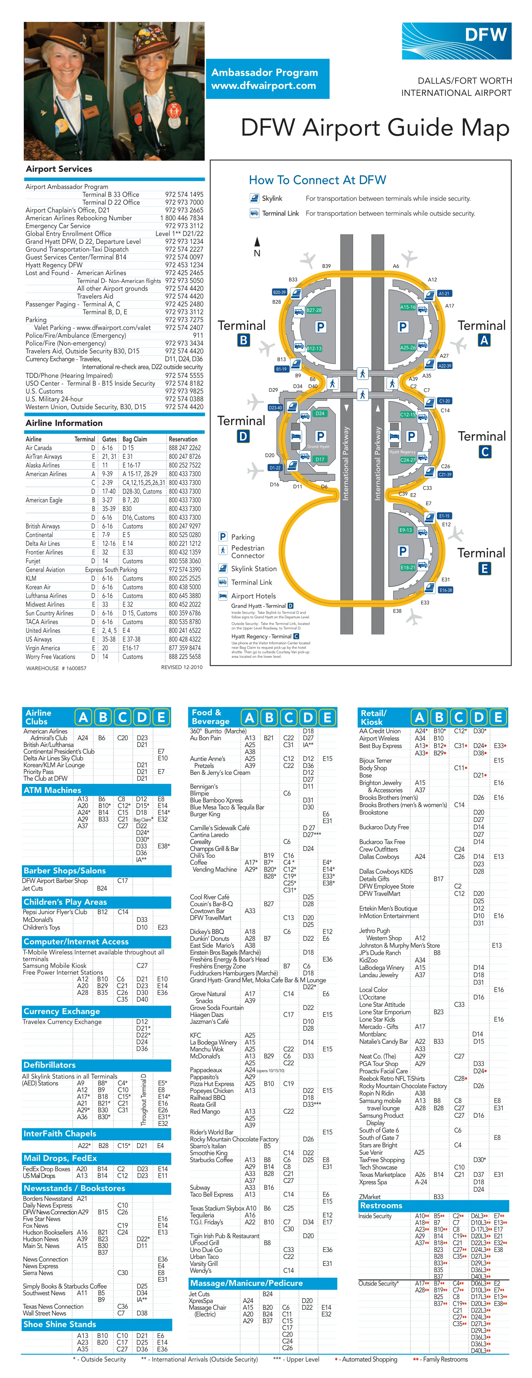
Terminal Link shuttle stops are at specific “Entry” door nodes, with pickups on the Upper/Departures level for A, B, C, and E—but on the Lower/Arrivals level only at Terminal D.
| Terminal | Level | Exact door / entry node | Nearest landmark anchor |
|---|---|---|---|
| A | Upper (Departures) | Entry A10 | DART Rail access signage zone |
| A | Upper (Departures) | Entry A29 | high-number A-gates curbside zone |
| B | Upper (Departures) | Entry B14 | low-number B-gates curbside zone |
| B | Upper (Departures) | Entry B43 | TEXRail access signage zone |
| C | Upper (Departures) | Entry C4 | low-number C-gates curbside zone |
| C | Upper (Departures) | Entry C30 | high-number C-gates curbside zone |
| D | Lower (Arrivals) | Entry D17 | D1–D22 curbside core |
| D | Lower (Arrivals) | Entry D29 | D23–D40 curbside core |
| E | Upper (Departures) | Entry E14 | E2–E18 curbside zone |
| E | Upper (Departures) | Entry E35 | E20–E38 curbside zone |
Where is the International Arrivals / CBP exit located (terminal, level, door) and what is the shortest route from there to: a) Skylink re-entry b) rideshare pickup c) rental car transfer?
A TSA re-screening is mandatory after CBP because the CBP exit places you landside at Terminal D. The CBP exit is on Terminal D, Lower Level (Level 1), centered on the D22/D23 vertical core after baggage claim and customs.
| Destination | Node → Connector → Node | Exact doors / level changes | Adjacent anchor point |
|---|---|---|---|
| a) Skylink re-entry | CBP Exit (D, Level 1) → Connecting Flights bag belt → public arrivals hall → elevator/escalator core → Level 2 (Departures) → TSA D22 or TSA D30 → Level 3 → Skylink | start Level 1; up to Level 2 for TSA; up to Level 3 for Skylink | D22/D23 core; TSA D22 (center) or TSA D30 (south) |
| b) Rideshare pickup | CBP Exit (D, Level 1) → elevator/escalator core → Level 2 (Departures) → exit to upper curb → Ride App pickup zone | rideshare not on Level 1; go up to Level 2; doors D15–D25 | upper-level doors D15–D25 with “Passenger Pickup / Ride App” signage |
| c) Rental car transfer | CBP Exit (D, Level 1) → walk straight out → lower curb → Rental Car Shuttle → Rental Car Center | stay Level 1; exit via doors near D22/D24 to lower roadway | Blue/White Rental Car Shuttle on lower-level curb |
From a given gate area in Terminal D, what is the shortest route to: a) baggage claim b) rideshare pickup c) rental car transfer?
The shortest Terminal D gate-to-ground routes pivot on the D22 vertical core, because it drops you directly from the secure concourse to Level 1 arrivals or Level 2 curb exits without crossing the full retail atrium. From D-gates, the critical choice is “down for baggage/rental” vs “out on Level 2 for rideshare.”
| Destination | Node → Connector → Node | Level changes | Landmark triangulation |
|---|---|---|---|
| a) Baggage claim | Gate area (ex: D22) → exit secure area → D22 core → Level 1 (Arrivals) → baggage claim cluster | Level 2 → Level 1 | D22 core aligns with center terminal claim bands (D16–D30 cluster area) |
| b) Rideshare pickup | Gate area → exit secure area → Level 2 (Departures) → doors D15–D25 → Ride App pickup curb | none if already Level 2; otherwise up to Level 2 | doors labeled D15–D25 on upper curb |
| c) Rental car transfer | Gate area → exit secure area → D22 core → Level 1 (Arrivals) → doors near D22/D24 → lower curb → Blue/White rental car shuttle | Level 2 → Level 1 | lower-level curb at D22/D24 for rental car shuttle |
Where are TSA checkpoints in each terminal (exact position), and which checkpoint best aligns with specific gate clusters to minimize walking?
TSA checkpoints at DFW are positioned as named nodes (A12, B30, D22, etc.) that each “own” a gate band, so the shortest walk comes from entering at the checkpoint whose gate range matches your departure cluster. Checkpoints C20 and E18 function as the late-night fail-safes because they run 24 hours in the posted operating set.
| Terminal | TSA checkpoint node | Best-aligned gate cluster | Position cue for finding it | Posted feature note |
|---|---|---|---|---|
| A | A12 | A1–A16 | low-number A-gates side | standard |
| A | A21 | A17–A39 | main A checkpoint zone | PreCheck |
| A | A35 | A33–A39 | far high-number A-gates side | standard |
| B | B9 | B1–B14 | low-number B-gates side | standard |
| B | B30 | B15–B49 | main B checkpoint zone | high-capacity |
| C | C10 | C1–C17 | low-number C-gates side | standard |
| C | C20 | C18–C29 | central C zone near C20 gates | PreCheck, 24-hour |
| C | C30 | C30–C39 | high-number C-gates side | standard |
| D | D18 | D1–D21 | low-number D-gates side | standard/automated lanes |
| D | D22 | D22 (center) | centered on the D22 core | PreCheck |
| D | D30 | D23–D40 | south/high-number D-gates side | PreCheck enrollment center |
| E | E8 | E2–E11 | low-number E-gates side | standard |
| E | E16 | E12–E19 | mid E zone near E16 | CLEAR / PreCheck |
| E | E18 | E20–E38 | south/high-number E-gates side | CLEAR / PreCheck, 24-hour |
Where are the major wrong-turn traps (forks, split corridors, mirrored elevators/escalators, two similar exits) that cause people to end up at the wrong curb or wrong level?
Terminal E has a “phantom connector” trap, Terminal D has a curb-level inversion trap, and Terminal E Satellite gates create a hidden time trap that cascades into missed boarding. These are the three map-consistent failure points that most often cause travelers to end up at the wrong terminal edge, wrong level, or with an unrecoverable backtrack.
- Terminal E “Phantom Connector”: Terminal C’s south end looks like it should connect to E, but the airside corridor dead-ends, forcing a 10-minute backtrack to C-South Skylink (near Gates C27–C35).
- Terminal D level inversion: Terminal Link pickups at D are on the lower/arrivals level (Entries D17/D29), while rideshare is on the upper/departures curb (doors D15–D25), causing people to wait on the wrong roadway.
- Terminal E Satellite timing error: Gates E22–E30 require the underground tunnel segment near E21, adding ~10 minutes before you even reach the main E concourse nodes (including Skylink stations near E8–E11 or E31–E34).
What are the precise walk-time bands (in minutes) for: a) Skylink platform ↔ nearest gate cluster b) TSA checkpoint ↔ Skylink station c) gate cluster ↔ curb pickup zone?
Walk-time bands at DFW cluster into short, repeatable ranges because stations and checkpoints sit mid-concourse and vertical cores are predictable. The key variance is vertical movement (escalators/elevators) and whether you’re crossing a retail atrium (notably in Terminal D) versus a straight pier corridor.
| Segment | Node → Connector → Node | Walk-time band | Conditions / decision point |
|---|---|---|---|
| a) Skylink ↔ nearest gates | Skylink platform → escalator/elevator → nearest gate cluster | 3–5 minutes | includes vertical descent + short corridor |
| b) TSA ↔ Skylink | TSA checkpoint → concourse corridor → escalator/elevator → Skylink platform | 3–6 minutes | varies by lift availability + checkpoint position |
| c) Gates ↔ curb pickup | gate cluster → exit secure area → vertical core → curb doors | 5–8 minutes | includes typical terminal vertical transition buffer |
Where is the DART Orange Line station relative to terminal entry points (which terminal access, exact connector/bridge path, level changes)?
The DART Orange Line station connects to Terminal A via Entry A10 on the lower (arrivals) level, reached by exiting the building and following the walkway at grade under the roadway overhang. From other terminals, the shortest map-supported method is Terminal Link to Terminal A, then walking to Entry A10.
| Origin | Node → Connector → Node | Level changes | Adjacent anchor point |
|---|---|---|---|
| Terminal A | Baggage claim → Entry A10 (Lower Level) → exterior walkway → DART station platform | none (at grade) | Entry A10 “DART Rail Access Point” zone |
| Terminals B/C/D/E | Terminal Link stop → Shuttle → Terminal A (Entry A10 zone) → exterior walkway → DART station | varies by terminal; arrive at A upper curb then route down if needed | Terminal Link node at A10 |
Where is the Rental Car Center / consolidated rental facility relative to terminals, and what is the exact transfer path (train/shuttle stop location, frequency if posted on map signage)?
The consolidated Rental Car Center sits at the south entrance of the airport and is reached from every terminal by the dedicated Blue/White rental car shuttle from the lower (arrivals) curb. The transfer is landside only, and the posted operating set indicates 24/7 service with a typical 5–8 minute shuttle frequency.
| Step | Node → Connector → Node | Exact stop location | Posted frequency / travel band |
|---|---|---|---|
| 1 | Terminal → lower curb | Arrivals level curb at all terminals | pickup is not on upper curb |
| 2 | Lower curb → rental car shuttle → Rental Car Center | Blue/White “Rental Car Shuttle” bays | 5–8 min headway; ~10–15 min ride from Terminal A to RCC |
Where are rideshare pickup zones by terminal (exact level/curb letter/zone), and how do they differ from taxi/shuttle/parking shuttles?
Rideshare pickups at DFW occur on the Upper (Departures) curb at every terminal, while taxis, limos, and most shuttles use the Lower (Arrivals) curb—so the most common error is waiting on the wrong roadway level. Terminal D’s rideshare exits are explicitly called out as doors D15–D25 on Level 2.
| Terminal | Rideshare pickup node | Level | Differentiation from taxi/shuttles |
|---|---|---|---|
| A | Passenger Pickup / Ride App curb | Upper (Departures) | taxis/shuttles typically lower curb |
| B | Passenger Pickup / Ride App curb | Upper (Departures) | taxis/shuttles typically lower curb |
| C | Passenger Pickup / Ride App curb | Upper (Departures) | taxis/shuttles typically lower curb |
| D | Doors D15–D25 → Ride App curb | Upper (Departures / Level 2) | Terminal Link is lower level at D (Entries D17/D29) |
| E | Passenger Pickup / Ride App curb | Upper (Departures) | taxis/shuttles typically lower curb |
Where are the on-airport parking connectors (Terminal Parking, Remote, Express, etc.) and which pedestrian bridges/elevators connect to the correct ticketing level?
On-airport terminal parking connects into each terminal through specific pedestrian bridges or core elevators that feed directly into the ticketing/departures level. Terminal D is the outlier because its garage connection is primarily vertical (direct elevator access) rather than relying on multiple named bridge nodes.
| Terminal | Parking connector type | Exact connector nodes to terminal | Ticketing-level alignment cue |
|---|---|---|---|
| A | Terminal garage bridges | A13, A16, A29, A34 | bridges land into departures/ticketing side near those gate-number cores |
| B | Terminal garage bridges | near B4, B15, B29 | use the bridge closest to your check-in counter bank to avoid cross-terminal walks |
| C | Terminal garage bridges | near C8, C12, C27, C31 | pick the bridge matching your gate band (low vs high numbers) |
| D | Terminal garage core elevators | direct elevator access from garage | elevators take you to Level 2 (ticketing/departures) without hunting for bridge spans |
| E | Terminal garage bridges | near E8, E11, E31 | E31 aligns best for south/high-number E-gates and E Satellite travelers (extra tunnel time later) |
Archive Dallas Fort Worth International Airport Map
Below are all historical map versions for Dallas Fort Worth International Airport. Each year includes the official map available for that period, presented as both WebP and PDF.
2012 Dallas Fort Worth International Airport Terminal Map
2009 Dallas Fort Worth International Airport Terminal Map