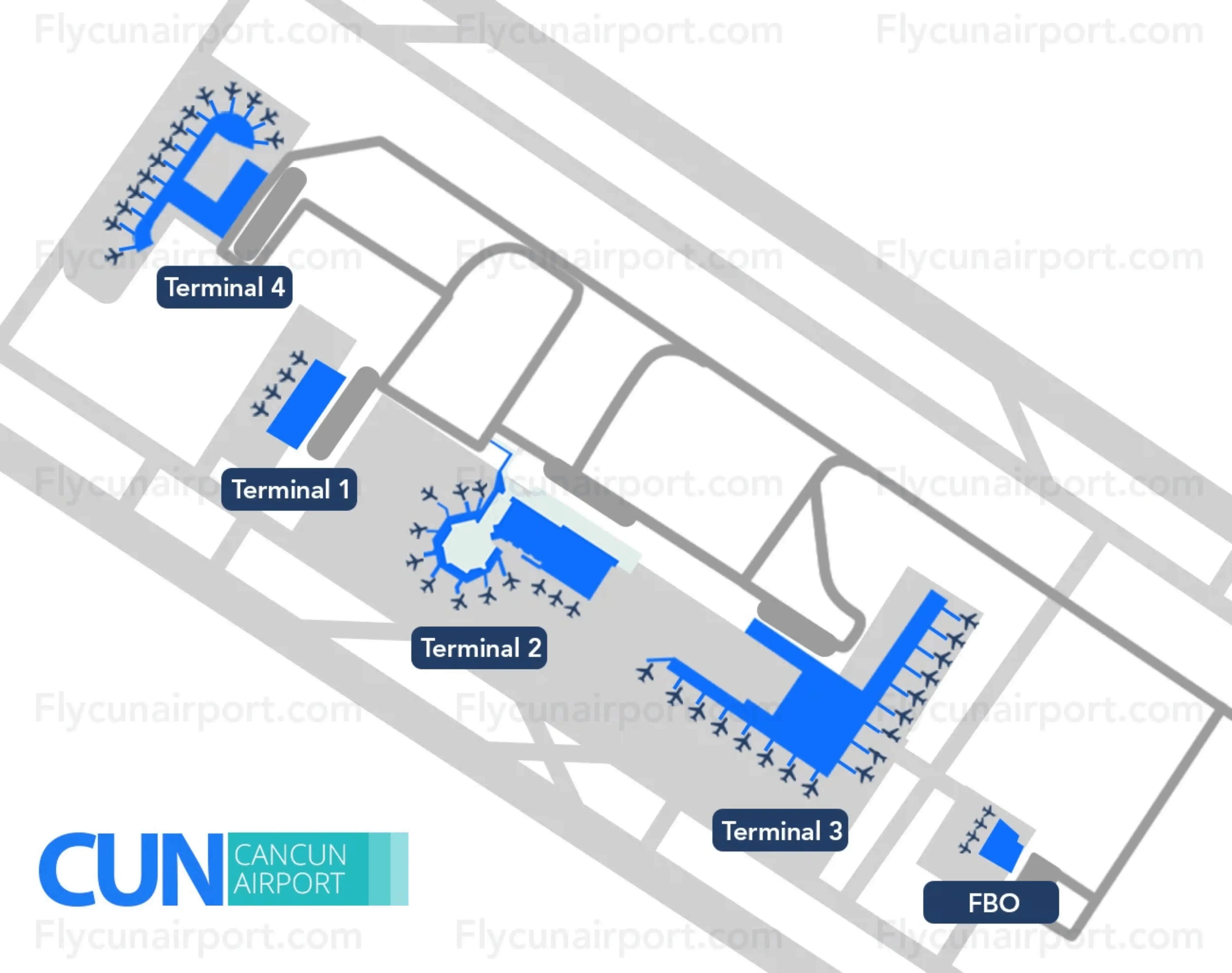
Cancún International Airport Map (Most Up-To-Date)
Cancún’s airport layout is long and linear, with separate terminals stretched along the main access road rather than clustered in a single building. Terminal 2 and Terminal 3 sit closest together, while Terminal 4 is newer and more separated, making curbside choices and shuttle routing feel higher-stakes on arrival. Within Cancún’s main airport complex, navigation is defined by where you exit customs, which side of the fence you land on, and whether you head to official platforms, parking-lot kiosks, or the inter-terminal shuttle loop.
Map Table
| Terminal | Key Airlines | Primary Function | Transfer Mode |
|---|---|---|---|
| Terminal 2 | Domestic carriers, ADO bus users | Domestic arrivals, ground-transport node | ADO bays (parking lot), inter-terminal shuttle |
| Terminal 3 | American, Delta, United | High-volume U.S. international arrivals | Inter-terminal shuttle, pre-booked transfers curbside |
| Terminal 4 | JetBlue, Southwest, European charters | Newest international arrivals, high-variance peaks | Cancun International Airport Map Strategy Treat arrivals as three phases: immigration hall, baggage/customs, then the curb—make your decisions at each threshold, not mid-corridor. Break the solicitation funnel by committing to official targets: “Ground Transportation / Hotel Shuttle” exits in Terminal 4 and the daylight line-of-sight exit in Terminal 3. In Terminal 2, default your feet to the parking lot side and hold the right-hand line to reach ADO before the taxi kiosks can redirect you. If you miss the correct exit, don’t “fix it” by stopping at counters—move to an exterior landmark first, then re-orient from a platform/pylon/curb marker.“Ground Transportation” platforms, inter-terminal shuttle |
Cancun International Airport Map Strategy
- Treat arrivals as three phases: immigration hall, baggage/customs, then the curb—make your decisions at each threshold, not mid-corridor.
- Break the solicitation funnel by committing to official targets: “Ground Transportation / Hotel Shuttle” exits in Terminal 4 and the daylight line-of-sight exit in Terminal 3.
- In Terminal 2, default your feet to the parking lot side and hold the right-hand line to reach ADO before the taxi kiosks can redirect you.
- If you miss the correct exit, don’t “fix it” by stopping at counters—move to an exterior landmark first, then re-orient from a platform/pylon/curb marker.
2026 Cancún International Airport Map + Printable PDF
Terminal 4 remains the primary pressure point for international arrivals volume, while Terminal 3 stays the densest “single-corridor” exit experience. Terminal 2 continues to be the ADO bus focal point, with ticketing and boarding oriented into the parking lot rather than the curb. The inter-terminal shuttle loop is still the default connector, but routing accuracy matters more than speed.
2026 Cancún International Airport Map Guide
What is the exact door/exit (by number or landmark) for the official free inter-terminal shuttle stop at Terminal 4 Arrivals?
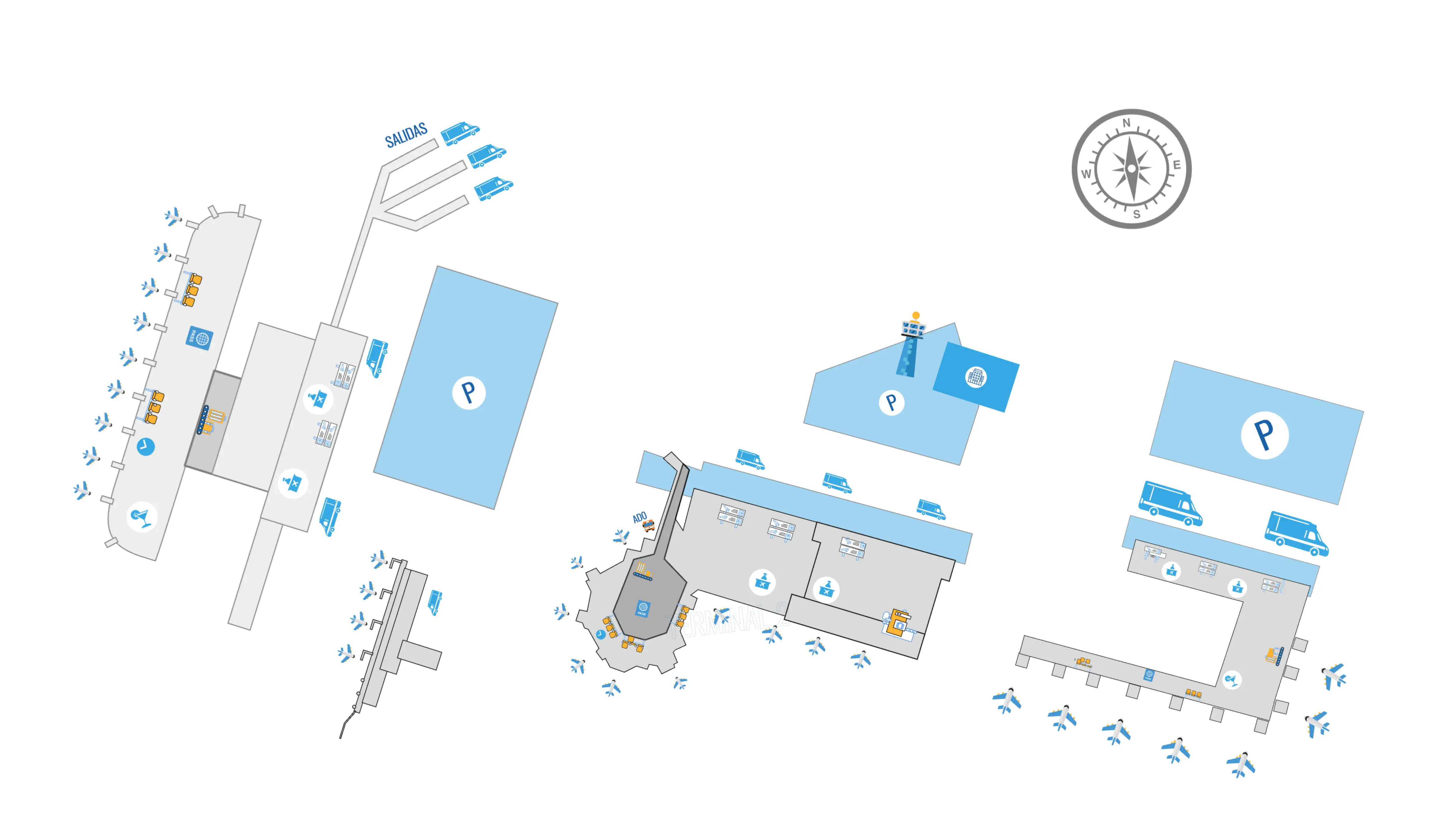
No numbered door is reliably used for the Terminal 4 free inter-terminal shuttle stop—access is controlled by taking the “Ground Transportation / Hotel Shuttle / Tour Operators” exit and getting onto the correct curbside platform side. The dealbreaker is that the “Friends & Family” exit puts you on the wrong side of the fence and blocks direct shuttle access.
The shortest, lowest-risk vector is: clear Customs, pass through the post-Customs corridor without stopping, then turn left at the binary exit node into the sliding doors marked “Ground Transportation.” Outside, stay on the covered platform lane (same side as pre-booked transfers) and scan the nearby bus-bay cluster for “Inter-Terminal Shuttle / Shuttle Loop” signage and a red/white airport shuttle bus, not the large red ADO coaches.
What is the walking distance (meters) from Terminal 3 Arrivals exit to the Terminal 2 Arrivals entrance using the safest pedestrian path?
Walking runs about 600–800 meters from Terminal 3 Arrivals to Terminal 2 Arrivals using the employee-style sidewalk line that tracks toward the Air Traffic Control tower. Time-on-foot is typically 8–12 minutes in heat and full sun.
Use this safest path: exit Terminal 3 Arrivals, turn left away from the densest curb chaos near Air Margaritaville, then follow the sidewalk parallel to the internal connecting road with the ATC tower as your forward anchor. Expect driveway crossings where service vehicles cut through; keep to the curb edge and cross only at clear sightlines. The path reconnects to the Terminal 2 frontage once you pass the Terminal 3 meeting/café zone and continue along the same road-facing sidewalk line.
Where does the “shark tank” corridor begin (first fixed landmark) after baggage/customs in Terminal 3 Arrivals?
The “shark tank” corridor begins immediately after the final set of opaque sliding doors that separate the Customs (baggage x-ray) area from the public-access hallway. That door threshold is the first fixed landmark where the environment flips from controlled processing to active solicitation.
Past those doors, you enter a long enclosed hallway with service booths lining both walls—car rental, taxi, and currency exchange counters—which is how you confirm you’re in the corridor. The cleanest navigation cue is to lock your sightline to the daylight and the distant glass exit doors at the far end and keep a center-line trajectory. Any stop at a left/right booth acts like a brake and increases interception risk.
What is the shortest mapped route from baggage claim to the pre-arranged transfer meeting area in Terminal 4 (with the last fixed landmark before you enter it)?
The shortest route is to clear Customs, walk straight through the post-Customs corridor without stopping, then take the left exit marked “Ground Transportation / Hotel Shuttle / Tour Operators” to reach the covered transfer platform area. The last fixed landmark before you enter the organized meeting zone is the sliding glass doors labeled “Ground Transportation.”
After you exit those doors, stay on the covered sidewalk/platform line and walk straight past the Mini Market toward the bar commonly identified as the Welcome Bar (sometimes linked to “Air Margaritaville”). The pre-arranged transfer companies stage by Platform C, identified by a large blue square pole/column marked with the letter “C.” If you can see the blue “C” pylon, you are past the fence separation and in the correct commercial transfer zone.
Where is the ADO ticket kiosk located at Terminal 2 (exact side of the arrivals exit / first landmark in the parking lot)?
The ADO ticket kiosk is in the Terminal 2 parking lot on the right-hand side as you exit Arrivals and face outward toward the lot. The first fixed cue is that it presents as the first booth/door you reach on the right, before you drift into the taxi-sales cluster.
Walk out of the Terminal 2 Arrivals doors and keep your trajectory straight toward the parking lot opening rather than hugging the curb. As you cross into the lot, hold right and look for the small ADO-branded ticket window/booth at the edge of the parking bays. The “New Taxi Kiosks” cluster is the counter-landmark on the left side of this same parking-lot entry zone; if you’re being funneled left into counters, you’re moving away from ADO.
What is the exact curb/bay position where ADO boards at Terminal 2 (relative to parking bay numbers or terminal-end landmarks)?
ADO boards from the bus bays inside the Terminal 2 parking-lot bay area adjacent to the ADO ticket kiosk, not from the main curbside drop-off lane. The dealbreaker is that if you stay on the terminal curb, you’ll be standing in taxi territory rather than at the bus platforms.
Use this orientation: exit Terminal 2 Arrivals, walk into the parking lot, then hold right to reach the ADO ticket kiosk; the boarding point is the next immediate zone beside it where the large red ADO coaches pull into marked bus slots. Look for bay signage that reads “Autobuses” / “Cancún Centro” / “Playa del Carmen” as the fixed platform identifiers. If you can see the ADO kiosk and the red buses in the same sightline, you’re at the correct boarding area.
Where is the entrance to the “digital passport / e-gate” processing area in Terminal 3 Arrivals (first visible sign/landmark from the main queue)?
The Terminal 3 e-gate entrance is on the far left side of the immigration hall, identifiable by subway-style turnstiles with glass barriers. Those glass turnstiles are the first visible landmark that distinguishes the e-gate lane from the central manual queues.
After descending into the main immigration hall, do not join the middle stanchions by default—scan left across the room for the glass-barrier gates and the separate lane feed. The easiest triangulation is: escalator/stairs behind you, officer booths centered ahead, and the e-gate turnstiles offset hard left. Eligibility is adults (18+) from the U.S., Canada, and the U.K.; attempting to bring minors into this lane typically forces a return to the manual queue.
What is the maximum physical queue footprint for immigration at Terminal 4—i.e., which landmark is the “line back-up” boundary?
The immigration queue can back up to the base of the escalators and stairs that deliver passengers into the Terminal 4 immigration hall. That escalator/stair landing zone is the practical “line back-up” boundary during peak arrival banks.
When the hall is saturated, the stanchioned lanes near the booths stop being the true start of the line and the crowd forms a loose pre-queue clump at the escalator bottoms. The usable tactic is to assess lane density before you descend, because the upper-level sightline is the only clean overview of where the organized stanchions begin versus where the spillover begins. If you step off the escalator directly into a dense standing mass with no stanchions visible, you’re already at the maximum footprint zone.
Which baggage carousel numbers/zone serve JetBlue (Terminal 4) and where is the carousel-change announcement board located relative to the belts?
No fixed carousel numbers are permanently assigned to JetBlue in Terminal 4—belts are allocated dynamically based on real-time operations. The primary dealbreaker is assuming a “JetBlue carousel” and walking deep into the hall without first confirming the assignment.
The carousel-change announcement boards (FIDS screens) are positioned immediately at the transition from immigration into baggage claim—overhead at or just past the entrance threshold into the carousel hall. Use the moment you clear immigration as a hard stop: look up at the screens, note your belt number, then walk directly to that carousel. If you’re already between belts and still searching for flight/belt info, you’ve moved past the information nexus and increased confusion time.
What is the walking distance (meters) from the immigration exit to the farthest baggage belt in Terminal 4?
Walking is about 50–80 meters from the Terminal 4 immigration exit to the farthest baggage belt. The transition is intentionally compressed, so anything that feels like a multi-minute trek usually indicates you’ve drifted into a side corridor or pause zone.
From the immigration exit threshold, you pass a short buffer zone that can feel like a duty-free “slow-down” funnel before the space opens into the carousel hall. The practical navigation cue is the overhead flight/belt screens near the baggage-claim entry: confirm your belt there, then walk straight to the assigned carousel. If you’ve walked longer than roughly two minutes without seeing belts, pivot back toward the immigration-to-baggage threshold area where the screens and main flow converge.
Where is the first “taxi kiosk” cluster located at Terminal 2 relative to the ADO kiosk (left/right + nearest fixed landmark)?
The first taxi kiosk cluster is on the left side of the Terminal 2 parking-lot access area, opposite the ADO ticket kiosk on the right. The nearest fixed landmark pairing is the parking-lot entry/exit opening directly outside the Terminal 2 Arrivals doors: taxis screen the left, ADO sits as the first booth/door on the right.
Exit Terminal 2 Arrivals and walk toward the parking lot rather than staying curbside. As you face outward into the lot, treat “left” as the taxi wall and “right” as the bus solution line. If you’re being engaged by multiple agents at counters before you can see the ADO window, you’ve drifted left into the taxi cluster; correct by crossing back to the right edge of the parking-lot flow until the ADO kiosk comes into view.
Where is the earliest physical “gauntlet point” where taxi hawkers start intercepting passengers between baggage claim and curbside in Terminal 4?
The earliest gauntlet point is immediately after Customs, when you exit the customs area through the sliding glass doors off the “traffic light” channel. That door threshold is where the semi-secure corridor begins and interception starts.
Directly past those doors, Terminal 4 funnels you into a sterile corridor lined with car rental counters and timeshare-style kiosks on both sides. Solicitors often present as uniformed staff and may ask to “see your receipt” or “validate your transfer,” using the counters as interception nodes. The clean evasion vector is to keep moving down the corridor without stopping until the binary exit decision at the far end, then take the left-side “Ground Transportation / Hotel Shuttle” doors to reach the covered platform area.
What is the exact walking distance (meters) from the Europcar return area to Terminal 2 check-in doors, and which segment lacks sidewalks?
Walking is about 350 meters from the Europcar return area to the Terminal 2 check-in doors, with a 5–8 minute exposure window depending on luggage and heat. The dealbreaker is that the route is not continuously pedestrianized and forces you into vehicle-space.
The sidewalk gap occurs along the service-road and car-park transition: after leaving the Europcar return area on the access road side, you cross/track along the service roadway and then traverse sections of the parking area where defined sidewalks disappear. In that segment, pedestrians typically end up on the road shoulder or cutting through active vehicle lanes on broken asphalt/gravel. The lowest-risk tactic is to use the Europcar shuttle as the primary vector and treat walking as a contingency only when you can maintain clear sightlines and controlled driveway crossings.
Where is the landside “safe wait” meeting point immediately outside the terminal exit (bar/landmark), and what is its exact position relative to the final doors?
The safest landside “wait here” anchors are the Air Margaritaville Bar outside Terminal 3 and the Welcome Bar on the covered platform walk outside Terminal 4. Both are positioned so you can clear the final doors, get out of the counter-lined corridor, and re-orient in open air without stopping in the solicitation lane.
| Location | Safe-wait landmark | Exact position relative to the final doors | Fast verification cue |
|---|---|---|---|
| Terminal 3 Arrivals | Air Margaritaville Bar | Immediately outside the final glass doors at the end of the post-Customs corridor; walk straight out, then veer slightly right toward the bar frontage | Transfer reps behind metal barricades in the plaza just past the bar |
| Terminal 4 Arrivals | Welcome Bar near Platform C | Outside the sliding doors marked “Ground Transportation / Hotel Shuttle”; stay on the covered sidewalk/platform and walk straight past Mini Market toward the bar | Large blue square pole/column marked “C” at the organized transfer platform |
Archive Cancún International Airport Map
Below are all historical map versions for Cancún International Airport. Each year includes the official map available for that period, presented as both WebP and PDF.
Cancún International Airport Map 2024