Brisbane International Airport Map (Most Up-To-Date)
Brisbane Airport runs as a two-terminal system—an International Terminal and a separate Domestic Terminal about 4 km away—so most navigation stress comes from choosing the right transfer mode and level before you exit processing areas. The International Terminal stacks functions vertically (arrivals on Level 2, departures on Level 4) and splits ground transport by level, while the Domestic Terminal operates as its own check-in and gate complex. Both terminals sit within Brisbane’s primary airport grounds.
Map Table
| Terminal | Landside Levels | Core Passenger Zones | Inter-Terminal Connection |
|---|---|---|---|
| International Terminal | Level 4 / 2 / 1 | Level 2 arrivals + border processing; Level 4 check-in + security; Level 3 departure lounge + gates | transfer bus (Level 2 curb); Airtrain (via Level 3 skywalk) |
| Domestic Terminal | concourse-based | check-in halls; domestic security; gate piers | transfer bus drop-off zones; Airtrain station access |
Brisbane International Terminal Map Strategy
- Treat Level 2 as the bottleneck layer: move briskly through the duty-free intercept so you reach the SmartGate/kiosk threshold before the queue spills back into the retail corridor.
- Expect the biggest “where do I go?” moment at customs exit: decide taxi, transfer bus, Airtrain, rideshare, or Level 1 pick-up before the doors open so you don’t get trapped in the crowd buffer.
- For International → Domestic transfers, commit to one of two patterns: curb-to-curb (free transfer bus on Level 2) or vertical-up-to-rail (Airtrain via lifts/travelator to the skywalk entry).
- For rideshare, ignore the main curb: follow the north-end signed route and keep walking down the external ramp to the fenced pickup bays to avoid cancellations and backtracking.
2026 Brisbane International Airport Map + Printable PDF
This 2026 map focus is the same reality passengers feel on the ground: Level 2 arrivals can compress into slow, confusing queues, and the moment you exit customs you’re forced into a transport choice with different levels, doors, and walks. Use the printable view to lock in door/level decisions before you land—especially for Airtrain vs transfer bus vs rideshare.
Brisbane International Airport Domestic Terminal Level 1 Map 2025-2026
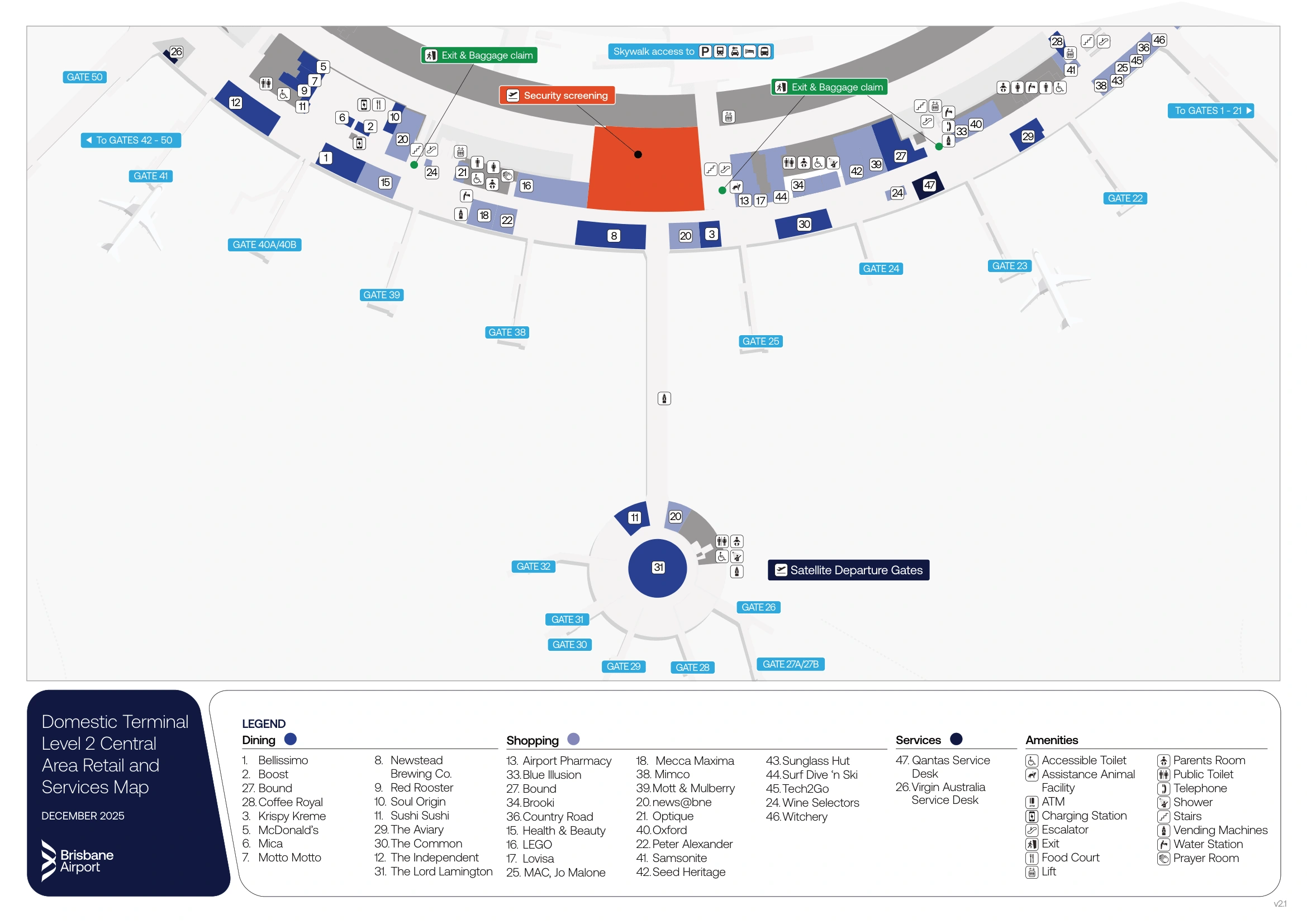
Brisbane International Airport Domestic Terminal Level 2 Central Map 2025-2026
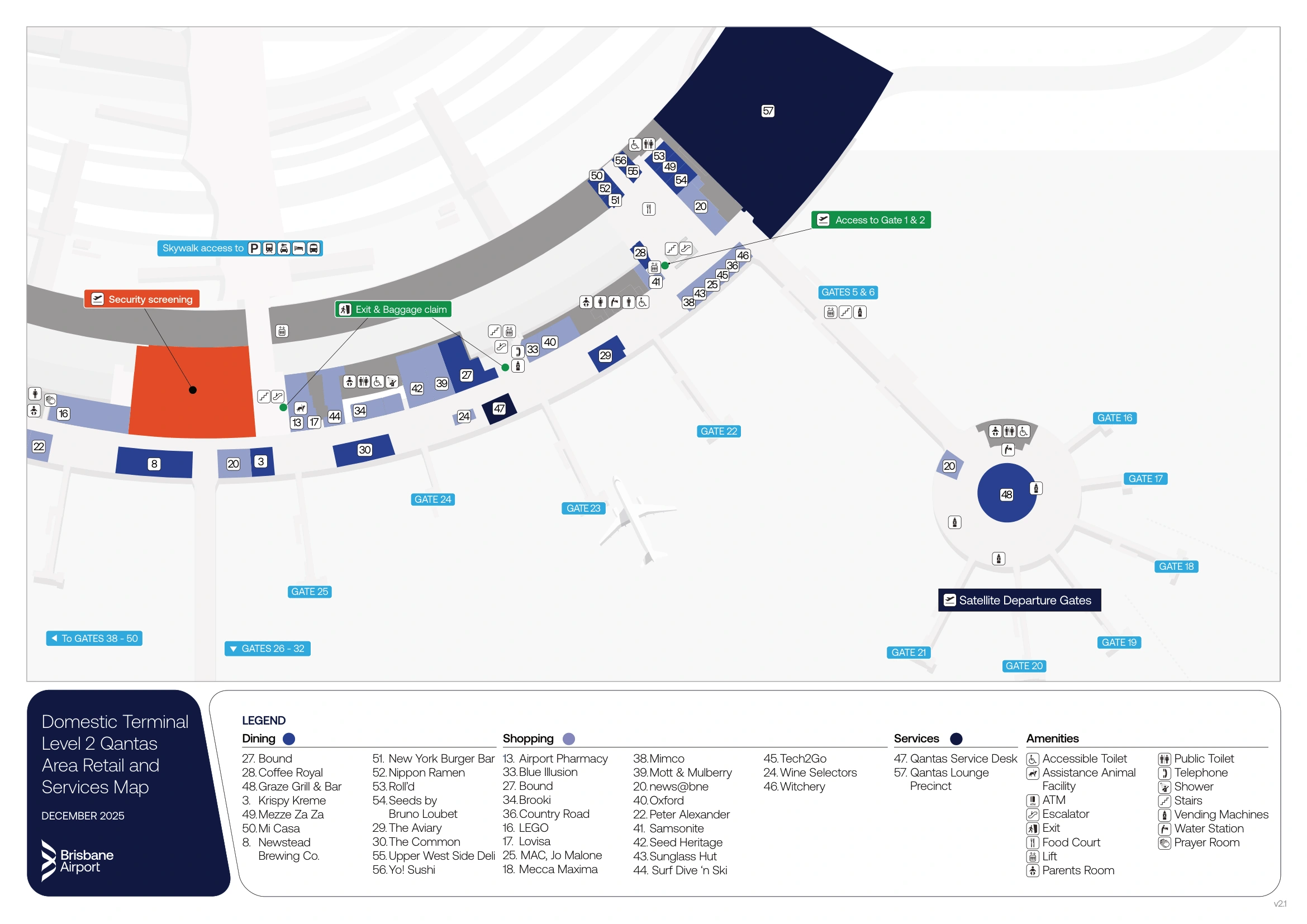
Brisbane International Airport Domestic Terminal Level 2 Qantas Map 2025-2026
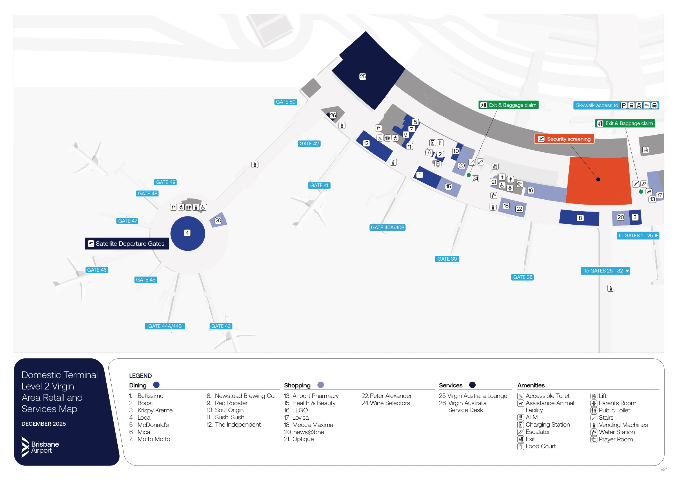
Brisbane International Airport Domestic Terminal Level 2 Virgin Map 2025-2026
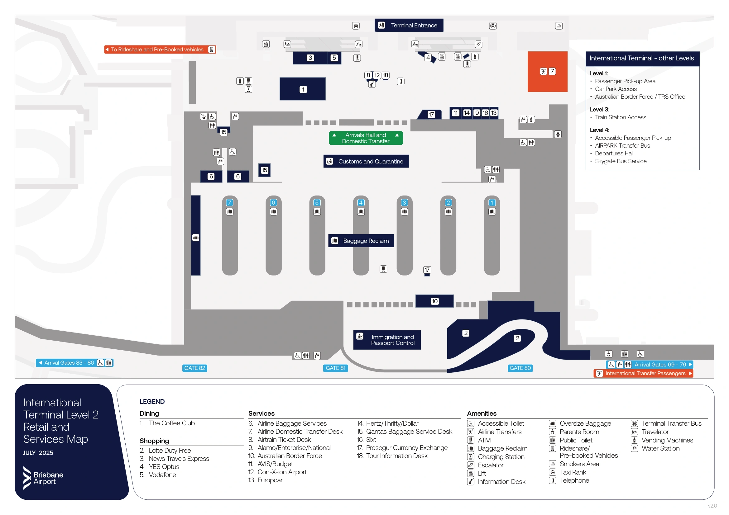
Brisbane International Airport International Terminal Level 2 Map 2025-2026
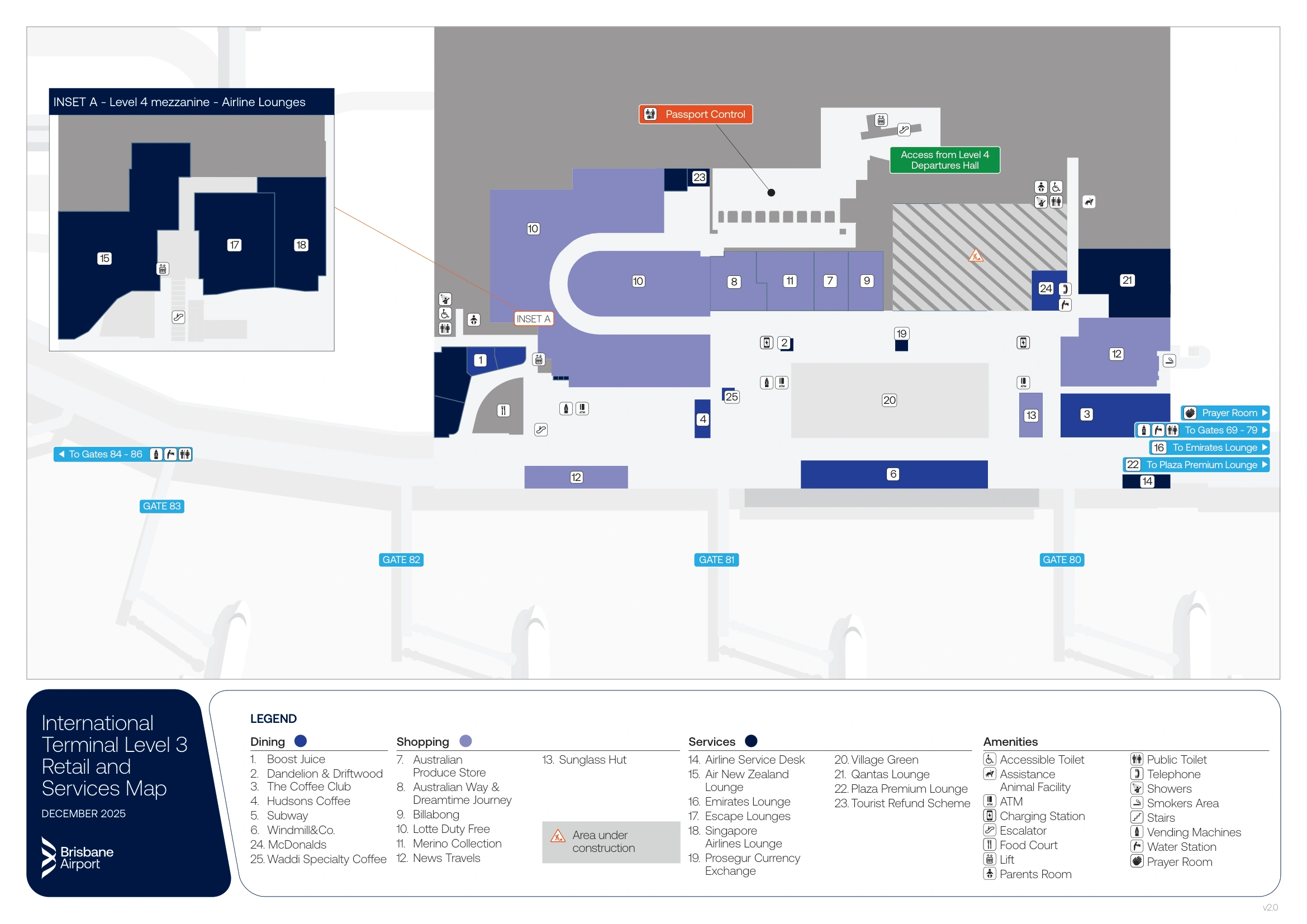
Brisbane International Airport International Terminal Level 3 Map 2025-2026
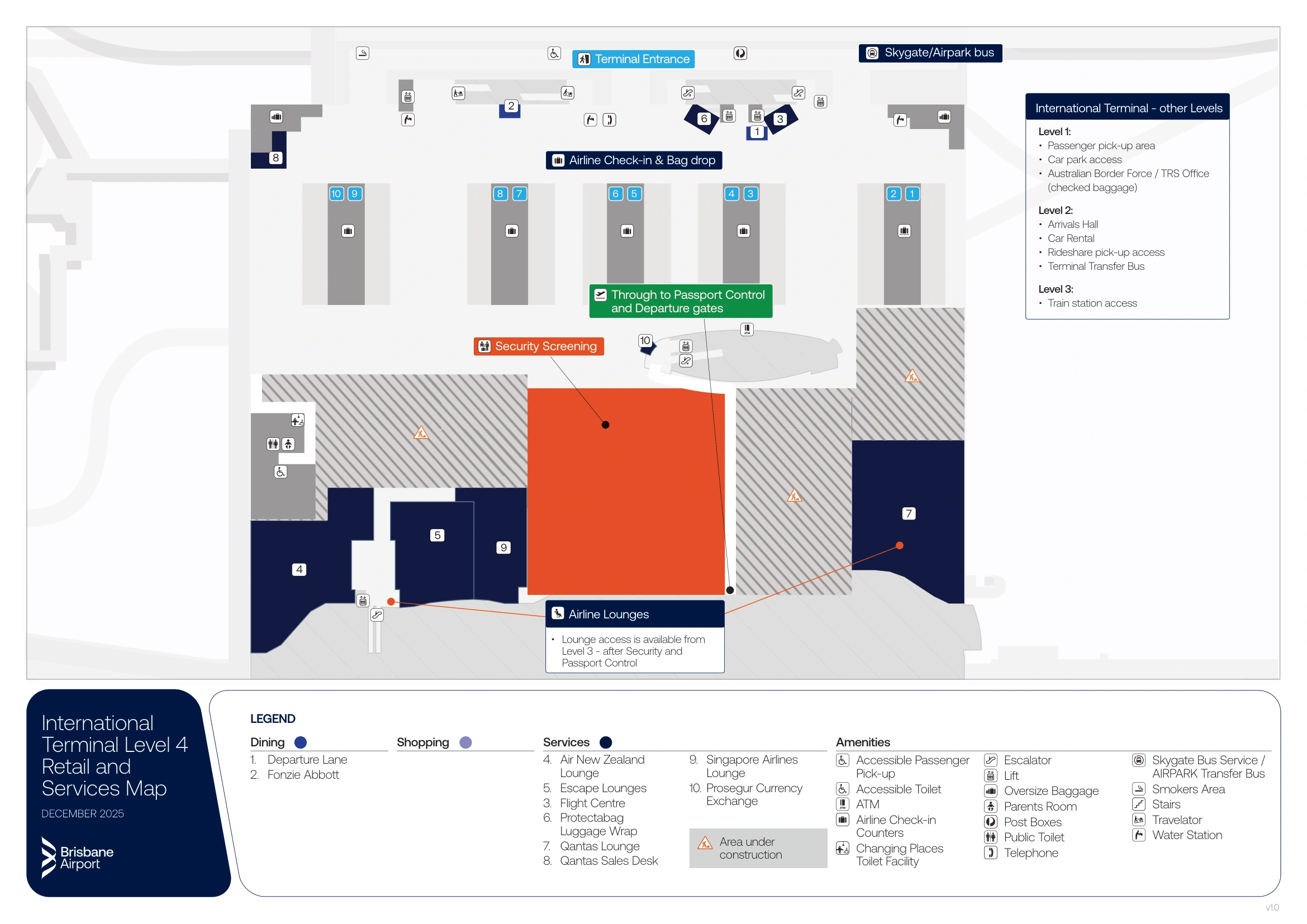
Brisbane International Airport International Terminal Level 4 Map 2025-2026
2026 Brisbane International Airport Map Guide
What is the point-to-point distance from the International arrivals exit doors to the Airtrain station entrance used to reach the Domestic Terminal?
Walking is approximately 200–250 meters from the International customs exit doors to the Airtrain station entrance, with an unavoidable vertical change. The route runs from Level 2 arrivals into the central lift/travelator core, up to Level 3, then across the pedestrian skywalk into the station entry.
A tight-connection path is: customs exit doors (Level 2) → central lifts/travelator bank (use the same core signed for “Trains”) → Level 3 concourse → pedestrian bridge/skywalk → Airtrain station entrance. The friction point is the lift step with luggage, and most delays come from hesitating at the arrivals hall “mode choice” node instead of committing straight to the blue “Trains” wayfinding.
Where is the International Terminal transfer bus stop located (exact door number and level)?
The transfer bus stop is on Level 2 (Arrivals), curbside outside the Arrivals Hall, signed with orange “Terminal Transfer” wayfinding. The bay sits toward the northern/central section of the Level 2 curb, separated from the taxi rank area.
From the customs exit doors, walk into the public Arrivals Hall and orient to the transport signage cluster, then follow the orange “Terminal Transfer” signs to the curb. The most reliable landmark is the sheltered, designated bus bay at the north side of the arrivals frontage; if you reach the inner-lane taxi queue under the main overhang, you’ve drifted too central and should angle back toward the north end bus area.
Where is the designated rideshare pickup zone for the International Terminal (exact door/level), and which signed path leads to it?
The rideshare pickup zone is at the Level 2 northern end, outside the main terminal footprint via the far-north exit doors, then down the external ramp into a fenced, numbered-bay area. The signed route uses “Rideshare” or “Pre-Booked Express” wayfinding, not the main curb.
From the customs exit doors on Level 2, turn left and walk past The Coffee Club in the Arrivals Hall. Exit through the far northern doors (the northernmost set of exits on Level 2), then follow the “Rideshare / Pre-Booked” signs away from the terminal frontage. Continue down the long open-air ramp until you reach the fenced pickup pen with numbered bays, where drivers match to bay numbers.
What is the shortest walking route from the International arrivals exit to the taxi rank, including the exact pedestrian crossing point?
The taxi rank is directly outside the International Arrivals Hall on Level 2, and no pedestrian crossing is required. The shortest route is a straight walk from the central arrivals glass doors to the sheltered curbside taxi queue on the inner lane immediately adjacent to the terminal frontage.
Exit customs into the public Arrivals Hall (Level 2) and head straight toward the main glass doors facing the roadway. Step outside under the building overhang and keep to the terminal-side footpath; the taxi rank forms along the inner lane beside the terminal face with taxi signage and a managed queue. The “crossing point” is effectively none on this route—do not use a zebra crossing or cross to an island (that applies to Level 1 passenger pick-up, not taxis).
What is the exact route from the baggage carousels to the biosecurity (customs inspection) exit, including where queues merge?
The biosecurity exit route is a forced merge from multiple baggage carousels into one funnel toward the “Customs & Quarantine” exit wall, with the queue tail commonly forming between Carousels 4 and 5. After you leave your carousel, you’ll be pulled into tensabarrier lanes that consolidate all streams before the staffed triage point.
From your carousel in the Level 2 baggage hall, angle toward the central exit wall signed “Customs & Quarantine,” not toward the side corridors. The merge happens at the marshalling area between the carousel field and the exit desks, where officers split passengers into Green (Nothing to Declare/Exit) or Red (Declare/X-ray). If the hall is congested, expect the queue to backfill into the carousel area—most often the tail sits in the gap between Carousels 4 and 5—so commit early to the barrier lane rather than hovering at the belts.
Where do immigration/SmartGate queues physically begin during peak arrivals (identify the nearest fixed landmark)?
The immigration queue physically begins at the exit of the Lotte Duty Free walkthrough on Level 2 during peak arrival banks. The formal lanes start at the SmartGate kiosk array at the Immigration Hall threshold, but when the hall saturates the line spills back up into the retail funnel.
After descending from the Level 3 arrivals corridor into Level 2, you’re forced through/alongside the duty-free intercept before border control. In quiet periods, the “start” is obvious: the first banks of SmartGate kiosks at the hall entry. In peak periods, treat the Lotte Duty Free exit as the real queue tail landmark—if you see people stopped at the end of the walkthrough, join there immediately instead of walking past and trying to merge later, because the corridor narrows and becomes the de facto queue channel.
What is the exact walking distance from the International arrivals corridor to the SmartGate/ePassport control entry at Brisbane Airport?
Walking is approximately 450–600 meters from the farthest northern arrival gate area (around Gate 86) to the SmartGate entry, and about 150 meters from the central pier convergence to the SmartGate entry. The path is a straight, linear corridor flow into the Level 2 Immigration Hall threshold.
Gate location sets your baseline: northern pier arrivals (Gates 80–86) have the longest approach, and southern pier arrivals (Gates 69–79) are similar in overall geometry, converging on the central “descent node” escalators down to Level 2. Use the top of the descent node as your orientation anchor—once you funnel down and clear the duty-free intercept, the SmartGate hall entry is the next major boundary. In peak banks, the functional “entry” can feel earlier because the queue may backfill into the duty-free exit area.
After International security screening, what is the walking distance from the main screening exit to the farthest departure gate area?
Walking is approximately 450–500 meters from the main post-screening exit to the farthest gate areas (Gate 86 on the northern pier or Gate 69 on the southern pier). Budget 10–15 minutes if the concourse is busy or you pause in retail.
After you clear Level 4 security, you descend to Level 3 and are funneled through the duty-free maze; use the main duty-free “exit” into the central departure lounge as your measuring anchor. From that central node, the terminal splits into two long spines: north to Gates 80–86 and south to Gates 69–79. Moving walkways are intermittent, so the walk time swings with crowd density and whether you hit a clear stretch in the pier corridor.
Where are the pay-to-use luggage trolley kiosks located at International (relative to Level 4 drop-off and check-in entrances)?
Paid luggage trolley kiosks are on Level 4 (Departures), positioned at the departures drop-off curbside, just inside the main check-in hall entrances, and at the entry to the car park pedestrian bridge into the terminal. These are the pay points you’ll hit when arriving by car or walking in from parking.
Relative to the Level 4 road frontage, the first kiosks sit outside near the drop-off doors so you can unlock a trolley before entering with heavy bags. A second cluster appears immediately inside the primary check-in entrances, where passengers who skipped the curbside option can grab one without backtracking. If you arrive via the car park link, look for kiosks at the terminal end of the pedestrian bridge before you fan out into the check-in rows.
Where is the public “meet & greet” waiting area immediately after customs exit, and how far is it from the exit doors?
The public meet-and-greet area is directly in front of the frosted glass customs exit doors on Level 2, held behind a stainless-steel barrier rail about 10–15 meters from the doors. The buffer zone creates a clear strip of floor where arriving passengers can step out and orient before entering the crowd.
As you exit customs into the Level 2 Arrivals Hall, you’ll see the railing line facing the entire exit door array across the central atrium space. Greeters congregate behind that rail because it’s the closest permitted waiting point, with clear sightlines to the doors. If you need a quick landmark for coordinating, use the barrier itself as the meeting edge rather than a shopfront—people drift, but the rail line stays fixed opposite the exit.
From the International check-in hall, what is the shortest walking distance to the nearest water refill point?
The nearest water refill point is by the rear toilet blocks on Level 4 behind the check-in rows, roughly a 1–2 minute walk (about 80–150 meters) from the central check-in area. It’s the landside fountain cluster positioned along the back wall of the departures hall.
From the middle of the Level 4 check-in floor, walk straight toward the rear of the hall (away from the curbside doors and toward the security end). Use the toilet blocks behind the check-in rows as the fixed landmark; the refill point sits adjacent to those restrooms, near the rear wall alignment around the Flight Centre side/central rear zone. If you’re standing at the check-in counters and can see the main security entry direction, keep going past the last row lines until you reach the toilets—don’t detour toward the curbside entrances.
Archive Brisbane International Airport Map
Below are all historical map versions for Brisbane International Airport. Each year includes the official map available for that period, presented as both WebP and PDF.
2025-2026 Brisbane International Airport Map (Official 2025 Edition)