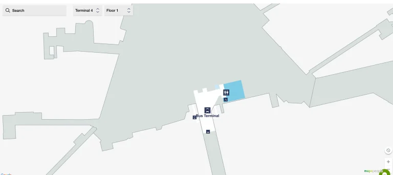
Cairo International Airport Terminal 3 Map (Most Up-To-Date)
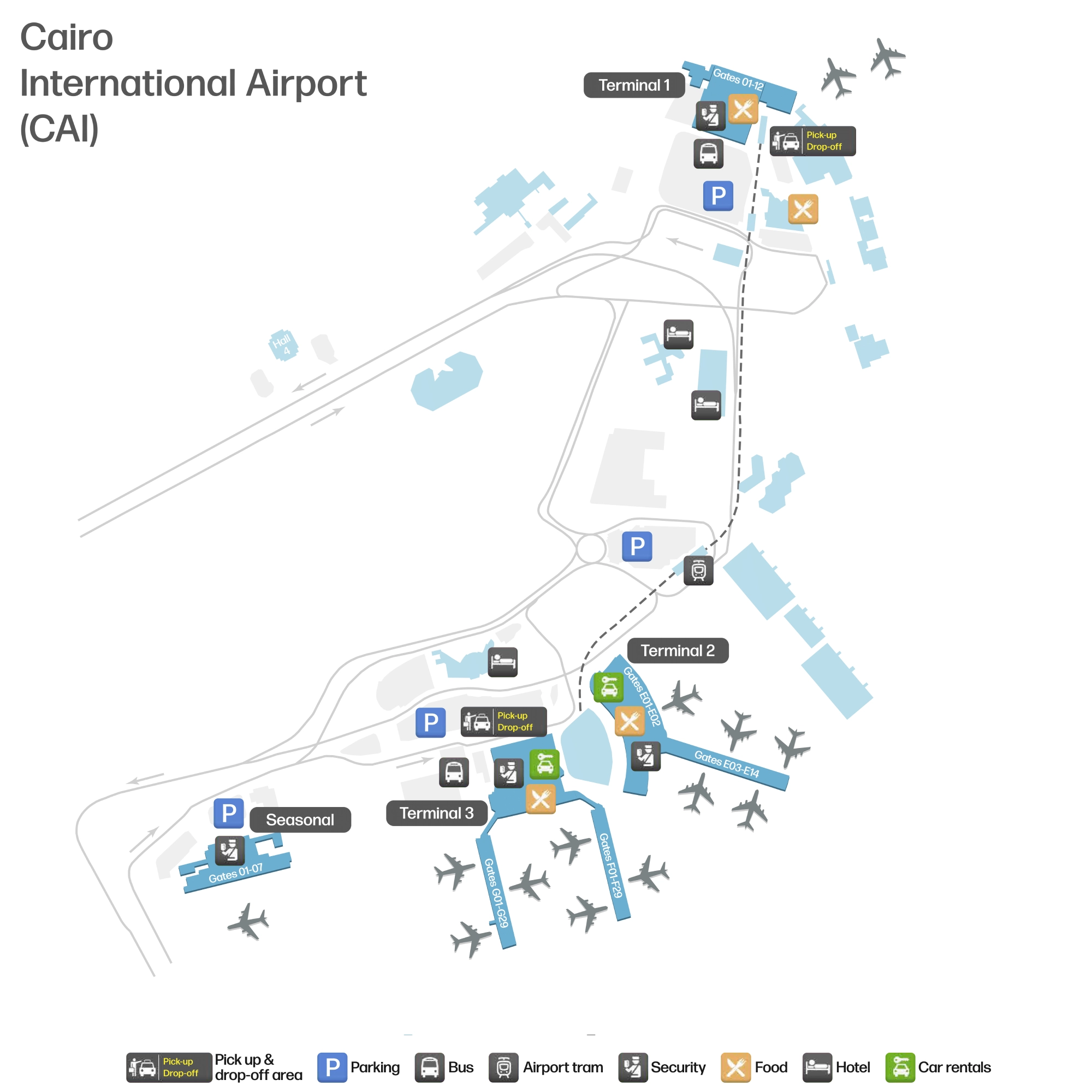
Cairo International Airport Terminal 3 is a large, inter-terminal people moverbi-level “main processor” building feeding two long gate piers (Concourses F and G), with Arrivals flowing on the lower level and Departures above. Within Cairo’s main airport complex, the terminal’s layout is defined by a central core (banks/transfer/vertical circulation) and long walks to pier-end gates, plus a dedicated transfer “down-and-up” re-screening loop that can surprise first-timers.
Map Table
| Level | Primary Areas | Key Connections | Friction Nodes |
|---|---|---|---|
| Departures | check-in islands, emigration, duty-free plaza, pier entries | airside bridge to Terminal 2, gate corridors F/G | gate-level secondary screening |
| Arrivals | arrival corridors, visa bank hall, immigration, baggage reclaim | transfer path back to departures, landside exit | visa fork, decision fork |
| Transit layer | transfer corridor, re-screening checkpoint | escalators down/up to airside departures | queue compression, vertical choke |
Cairo International Airport Terminal 3 Map Strategy
- Stay airside for T3 ↔ T2 whenever bags are through-checked and you already have a boarding pass; the airside bridge is the lowest-friction connector compared with any landside loop.
- Treat the Arrivals central core as a trap zone: the transfer path splits from the passport-control/baggage-claim exit flow, and the wrong turn can force a full landside reset.
- Resolve the visa fork before committing to immigration: visa bank counters sit before the immigration booths, and skipping them can trigger a high-penalty backtrack and re-queue.
- Budget time for the “down-and-up” transit loop: transfer passengers often descend to a re-screening checkpoint, then climb back up to Departures near duty-free before starting the long walk to F/G gates or bus-gate areas.
2026 Cairo International Airport Terminal 3 Map + Printable PDF
Terminal 3’s core footprint and the T3–T2 integration remain the defining map features in 2026: the airside pedestrian bridge for sterile connections, and the landside frontage walk for passengers who must enter Egypt. Expect multiple checkpoints (entry screening, re-screening for transit, and possible gate screening) and plan around long pier walks to F/G gates and remote-stand bus operations.
2026 Cairo International Airport Terminal 3 Map Guide
What is the exact pedestrian route between Terminal 3 Departures and Terminal 2 Departures (named corridors/bridges/doors shown on the airport map)?
The airside pedestrian bridge labeled for “Terminal 2 / Connecting Flights” is the direct walking route from Terminal 3 Departures to Terminal 2 Departures without going landside. From Terminal 3’s post-security central departures plaza (airside, near the Duty-Free core), follow overhead signs toward the F/G gates junction and the “Terminal 2” connector.
The path runs as a sterile enclosed bridge off the T3 departures airside zone, then delivers you into Terminal 2’s departures concourse on the airside side of screening. Use this route only if you are already airside (did not descend to immigration/baggage claim), have a boarding pass for the T2 flight, and your bags are through-checked; otherwise, the landside frontage walk becomes the functional route.
Where is the inter-terminal shuttle/bus pickup point for Terminal 3 Arrivals (precise door number/curb zone/level on the map)?
The practical inter-terminal pickup for Terminal 3 Arrivals is the Ground Level arrivals curb immediately outside the main Arrivals Exit Hall doors, where airport shuttle buses load from the curbside lanes. This is the same public frontage zone used by meeter-greeter traffic, so loading can feel chaotic and signage can be inconsistent.
If you want the more reliable mapped connector, the MiniMetro (APM) is reached by going up to Level 2/3 and taking the pedestrian bridge from Terminal 3 into the Multi-Story Car Park / Air Mall complex, where the station is integrated. That elevated bridge access point is the key landmark: once you’re on the bridge to the parking/air-mall structure, you’re on the correct path to the inter-terminal people mover rather than the curbside bus zone.
Where is the EgyptAir transit/transfer counter inside Terminal 3 (exact hall/level and its nearest fixed landmark on the map)?
The EgyptAir transit/transfer counter sits in the Terminal 3 Arrivals Concourse in the central core, positioned before the descent toward the Immigration Hall. It is adjacent to the Visa Bank buffer zone and closest to the escalators that drop down into the transit security re-screening level.
Passengers coming off the arrival corridors from Concourses F/G reach the central junction, then follow “Transfer / Connecting Flights” into the Arrivals Concourse holding area. The transfer counter is in that same central hall, separated from the visa-bank area by barriers/partitions, and it anchors the start of the transfer flow. The most reliable fixed landmark is the down-escalator/stair bank leading to the transit re-screening checkpoint; if you can see the descent point to screening, the transfer counter is nearby in the same node.
What is the walking distance (meters) from the Terminal 3 transfer desk to the bus staging/waiting area referenced by travelers (mapped path, not straight-line)?
Walking is typically 600–900 meters from the Terminal 3 transfer desk to the remote-stand bus staging/waiting area, following the mapped transfer flow rather than a straight line. The distance varies by which pier (F vs G) and how far down the concourse your bus gate lounge sits.
| Segment | Map anchor | Typical distance |
|---|---|---|
| Transfer desk → down to transit layer | escalators/stairs beside transfer node | 50–120 m |
| Transit re-screening → up to airside | X-ray/magnetometer checkpoint → up escalators | 80–180 m |
| Airside exit → central duty-free core | duty-free plaza edge | 80–160 m |
| Duty-free core → pier walk → bus-gate lounge | toward Concourse F/G, then down to bus area | 300–500 m |
For a T3 → T2 landside transfer, what is the shortest mapped path from Terminal 3 baggage claim to the Terminal 2 security entrance?
The shortest landside path runs from Terminal 3 baggage reclaim out to the public Arrivals Hall, then along the exterior frontage sidewalk to Terminal 2, and up to the departures screening point. Once you commit to this route, you are fully landside and must re-enter through Terminal 2’s departures security sequence.
Exit baggage reclaim into the public Arrivals Hall and continue straight out to the Ground Level curbside doors. Facing the access road, turn right and follow the terminal-front sidewalk toward Terminal 2, passing the pedestrian bridge that leads to the Le Méridien Cairo Airport hotel as your key landmark. Enter Terminal 2 at the nearest public entrance off the frontage, then use elevators/escalators up to the Departures level to reach the Terminal 2 security entrance. This frontage walk is typically 400–500 meters outdoors between buildings, plus the vertical climb inside T2.
Where are the security re-screening checkpoints located for passengers moving from arrivals flow back into departures/airside in Terminal 3 (exact positions on the map)?
The transit security re-screening checkpoint is on the lower “transit layer” reached by descending from the Terminal 3 transfer node in the Arrivals Concourse. It sits directly below the central arrivals core—near the escalators/stairs beside the EgyptAir transfer desk—and feeds immediately into escalators that rise back up into the Departures airside zone near the Duty-Free plaza.
From the arrival gate corridors (Concourses F/G) you reach the central Arrivals Concourse, then follow “Transfer / Connecting Flights” toward the transfer desk area rather than “Passport Control.” The re-screening point is the first hard barrier after you go down: a full X-ray/magnetometer setup for carry-ons and passengers. After clearing it, the mapped flow forces an immediate “up two levels” return, emerging airside in the main departures core—this is the start of the long pier walks to F/G gates or any remote-stand bus-gate lounges.
Where is the passport control/immigration hall located relative to Terminal 3 arrival gates (which direction/level per the terminal map)?
Passport control/immigration is on the Arrivals level in Terminal 3’s central core, downstream from the arrival gate corridors and after the concourses funnel into the main building. From the arrival gates in Concourses F/G, you walk along the arrivals corridors toward the hub, then continue toward the “Passport Control / Baggage Claim” flow to reach the immigration hall.
The critical positional cue is the Arrivals Concourse junction before the descent: the transfer path splits away in the central node, while the immigration hall sits “forward” in the arrivals flow, past the visa bank buffer zone and into the immigration booth hall that forms the barrier between airside arrivals and the landside baggage reclaim area. Once you commit to the passport-control direction, you’re being pulled toward baggage claim and exit.
Where is the visa purchase point (bank/exchange/visa counter) located relative to immigration in Terminal 3 (exact placement on the arrivals map)?
The visa purchase point is in the banking buffer hall immediately before the immigration booths in Terminal 3 Arrivals. It sits in the open pre-immigration area reached after the arrival corridors converge in the central core, but before you enter the passport-control queue lanes.
On the arrivals map logic, you encounter the visa bank counters first, then the immigration booth hall directly beyond them. Use the fixed landmark of the immigration queue mouth: the bank kiosks are positioned just upstream of that entrance, in the same central node where passengers are deciding between “Transfer / Connecting Flights” versus “Passport Control / Baggage Claim.” This is the visa fork trap—if you pass the bank zone and join immigration without a visa sticker, you can be forced to backtrack against the inbound flow.
What is the mapped walking time/distance from Terminal 3 security to the furthest common EgyptAir gates (identify the longest “gate walk” risk)?
Walking is about 1,000 meters and typically 15–20 minutes from Terminal 3’s main post-security/departures core to the furthest pier-end gates commonly used by EgyptAir (the tip gates on Concourses F or G, often referenced as the “F1/G1 end”). This is the longest gate-walk risk because the route runs from the central duty-free/security exit all the way down a single pier with congestion and occasional non-functioning moving walkways.
From the security exit into the Duty-Free plaza (central landmark), continue straight into the relevant concourse spine (F or G) and keep to the main corridor until the final gate cluster at the pier tip. If your boarding pass indicates a remote stand, add extra buffer beyond the pier walk because you may be routed down to a bus-gate lounge before boarding.
If a flight uses a remote stand, where is the bus drop-off entry point into Terminal 3 (exact door/level on the map)?
The remote-stand bus drops passengers at the Ground Level bus arrivals entrances at the base of Terminal 3, where they enter through automatic glass doors into the lower arrivals access zone. This is not the same as walking off a jet bridge into the concourse; it’s a ground-entry vector that adds vertical circulation time immediately after you step off the bus.
After entering at ground level, the mapped flow pushes you toward escalators/elevators to reach the Arrivals level and join the main stream toward the central core (visa bank/transfer/immigration). The reliable landmark is the immediate “up” movement: if you arrive by apron bus, you typically enter at the building base, then climb to the Arrivals level before you see the main arrivals concourse junction where “Transfer” splits from “Passport Control.”
Where is the clearest “decision fork” in Terminal 3 where passengers must choose between connections/transfers vs exit/ground transport (map-labeled junction)?
The clearest decision fork is the central Arrivals Concourse junction at the end of the F/G arrival corridors, immediately before the descent toward the Immigration Hall. Overhead gantry signage splits the flow between “Transfer / Connecting Flights” and “Passport Control / Baggage Claim / Exit.”
This junction is a true trap point because committing to the passport-control direction pulls you into the visa bank → immigration → baggage claim gravity well, and reversing course can be difficult once crowd-control and queue lanes begin. Use the visa bank buffer hall as the fixed triangulation landmark: the transfer routing peels away at this node, while the immigration routing continues forward into the pre-immigration banking/queue area.
If attempting a Terminal 2 lounge visit before a Terminal 3 departure, where is the last practical crossing point back toward Terminal 3 without getting trapped landside (map-defined boundary)?
The last practical crossing point is the airside pedestrian bridge between Terminal 2 and Terminal 3 on the Departures level; once you pass passport control/immigration into landside, you must re-clear the full departures process to get back. Treat the immigration booth line as the point-of-no-return boundary.
Stay on the sterile Departures side in Terminal 2, then follow “Terminal 3 / Connecting Flights” toward the enclosed bridge. On the Terminal 3 side, the bridge delivers you back into the airside departures core near the main Duty-Free plaza and the F/G concourse junction. If you find yourself being funneled toward the Arrivals core (visa bank buffer hall → “Passport Control / Baggage Claim”), stop and turn back before the immigration queue mouth—crossing that line is what traps you landside.