San Francisco Bay Oakland International Airport Terminal 1 Map (Most Up-To-Date)
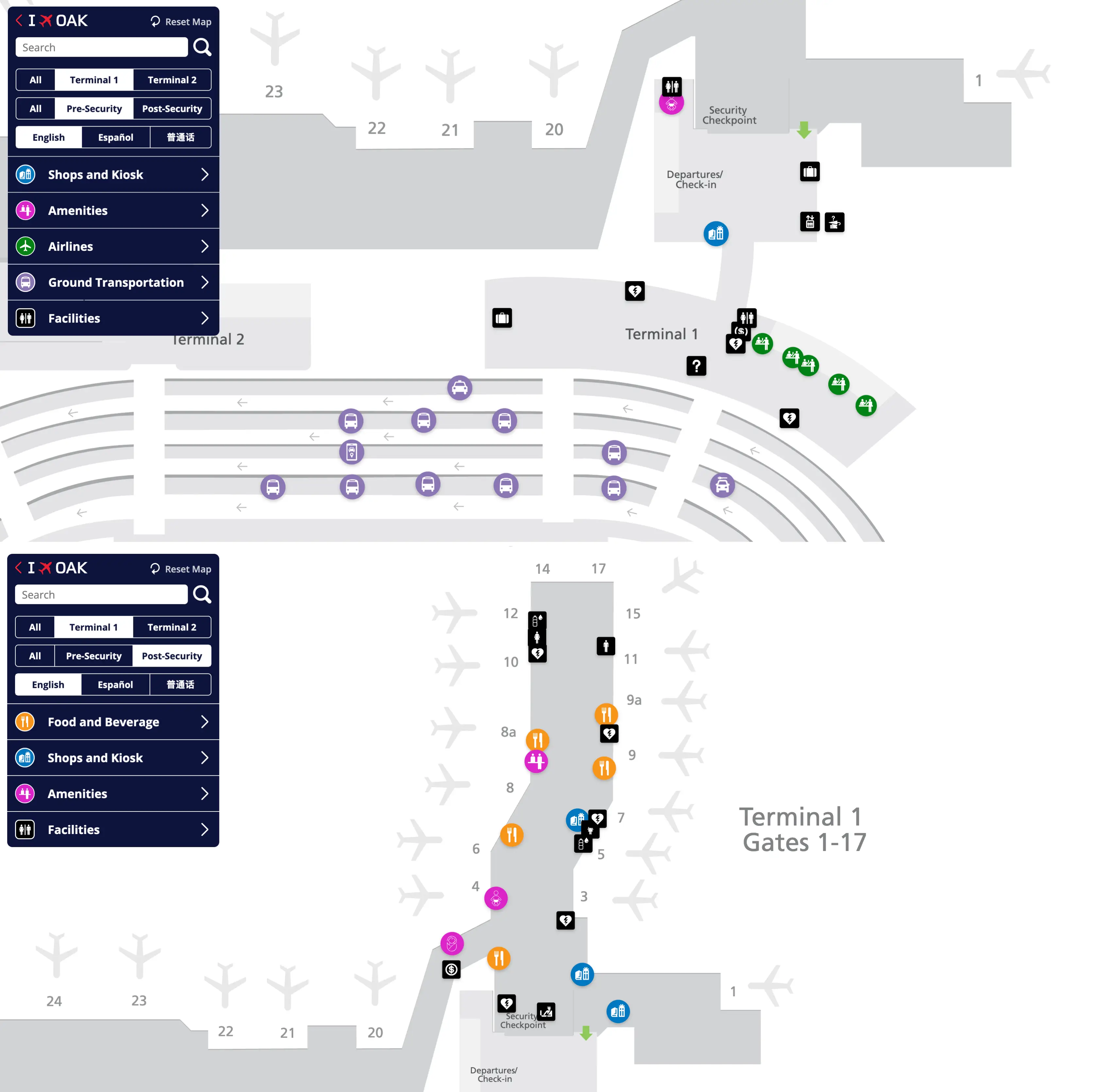
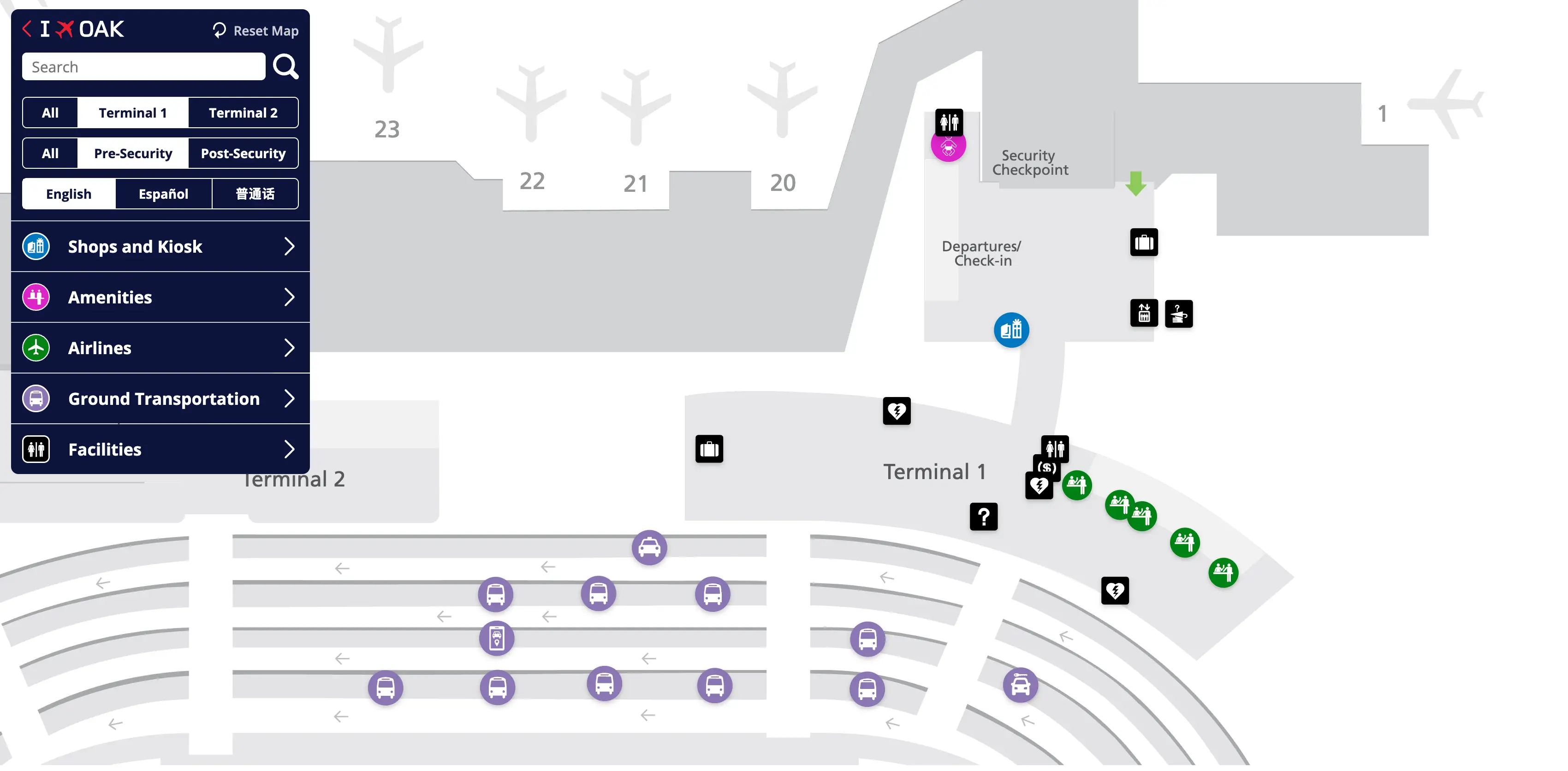
OAK Terminal 1 is a compact, legacy pier that feeds a straight concourse (Gates 1–17) from a central landside lobby and single main checkpoint, with the fastest “curb → checkpoint → gate” outcomes driven by one big choice: which checkpoint you use and whether you need the post-security link. Inside the East Bay’s main airport hub, Terminal 1 connects airside to Terminal 2 via a corridor by Gate 4, making gate number—not terminal branding—the reliable wayfinding truth.
Map Table
| Gate ranges | Airside connector | Security checkpoint | Key wayfinding anchors |
|---|---|---|---|
| 1–17 | Gate 4 ↔ Gate 20 | Central T1 | Gate 4 hub, Escape Lounge (Gate 8/8A), Gate 3 restrooms |
San Francisco Bay Oakland International Airport Terminal 1 Map Strategy
- Treat the checkpoint decision as a gate-based optimization problem: Gates 1–17 favor Terminal 1 screening; Gates 20–32 can still be reached from Terminal 1 via Gate 4, but the walk penalty is real.
- Commit at the first post-TSA fork: left/straight feeds Gates 1–17; right feeds Gate 4 and the connector to Terminal 2—missing that fork creates immediate backtracking friction.
- Assume negative constraints are “live”: Terminal 1 PreCheck is on the left side of the checkpoint but can be closed for late flights; Gate 4 women’s restroom closure forces a Gate 3 or Gate 8 restroom plan before the connector.
- Time-buffer far walks with measurable anchors: TSA exit → Gate 4 hub, Gate 4 hub → Gate 20, Gate 20 → Gate 32, and Gate 17 → baggage exit → 3rd Curb (Sections 3C2–3C9).
2026 San Francisco Bay Oakland International Airport Terminal 1 Map + Printable PDF
OAK Terminal 1 remains fully operational in 2026, but day-to-day walking lines can shift because the Terminal 1 check-in counter replacement work creates temporary detours in the ticketing lobby, and restroom renovations reshape “closest facility” assumptions near the Gate 4 junction. For printing, prioritize a map view that shows the Gate 4 ↔ Gate 20 connector, the Gate 3 restroom node, and the 3rd Curb rideshare islands.
San Francisco Bay Oakland International Airport Terminal 1 Pre Security Map 2025
San Francisco Bay Oakland International Airport Terminal 1 Post Security Map 2025
2026 San Francisco Bay Oakland International Airport Terminal 1 Map Guide
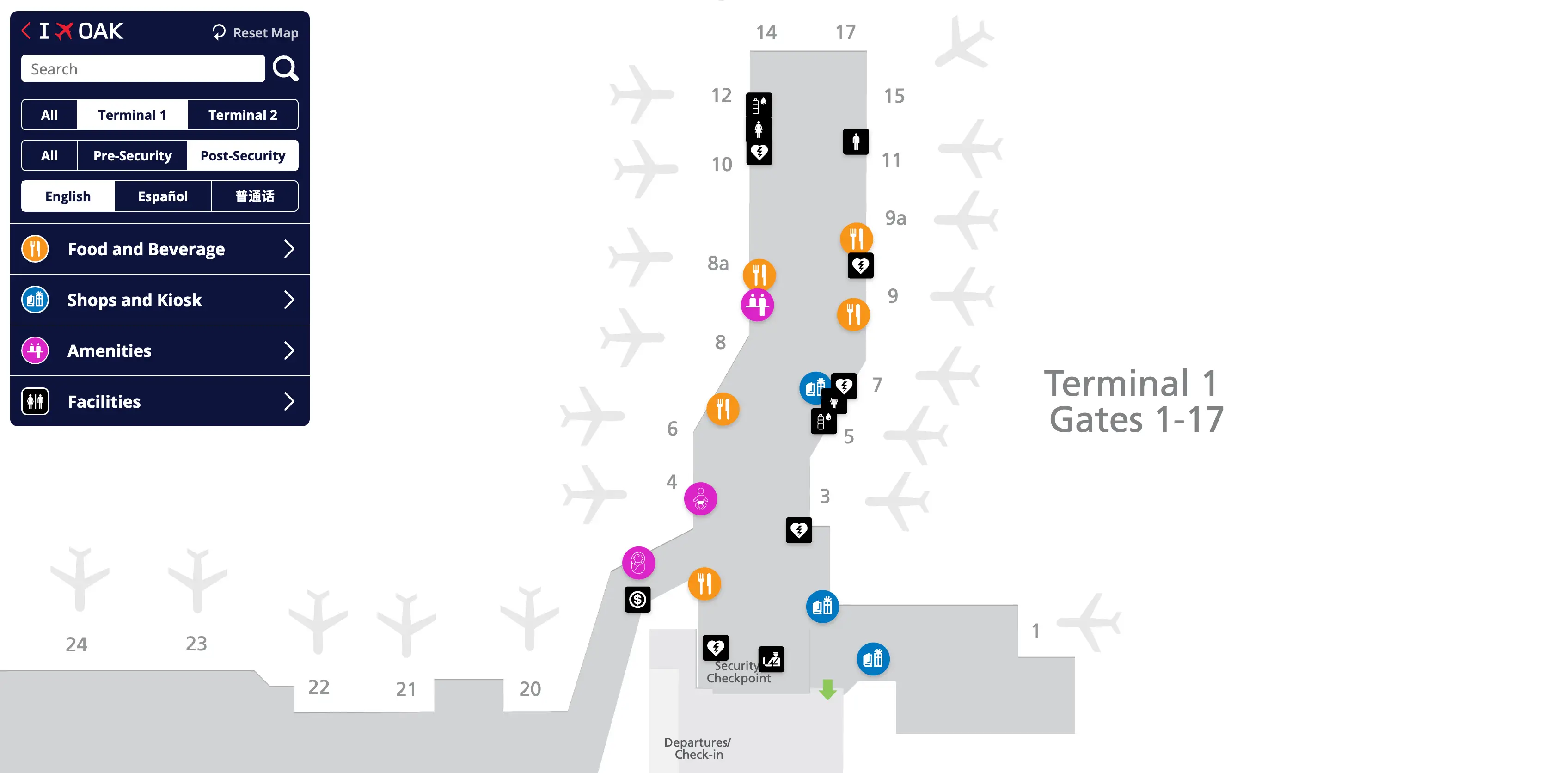
What is the shortest walking route from Terminal 1 TSA checkpoint exit to the Terminal 2 gate corridor (post-security), and where does that corridor begin?
The shortest route is the post-security connector corridor that starts at the Gate 4 junction in Terminal 1 and feeds into Terminal 2 at the Gate 20 entry area. From the Terminal 1 TSA exit, follow signs for Terminal 2 / Gates 20–32 and move right toward the Gate 4 hub, where the connector entrance begins.
From the scanners, stay with the main right-hand flow toward Gate 4 rather than continuing left/straight down the Terminal 1 pier toward Gates 6–17. The corridor itself is a dedicated indoor walkway between buildings (not a shuttle), and it delivers you into the Terminal 2 concourse at the start of the Gate 20 zone—this is the point where Terminal 2’s linear gate corridor effectively begins.
What is the exact walking time/distance from Terminal 1 TSA checkpoint to Gate 32?
Walking from the Terminal 1 TSA checkpoint to Gate 32 typically takes 10–15 minutes and covers about 0.4–0.5 miles. The route runs from the Terminal 1 security exit to the Gate 4 junction, through the post-security connector, then down Terminal 2’s concourse from Gate 20 to Gate 32.
The time is controlled by three measurable segments anchored on fixed nodes: the short approach from the TSA exit to the Gate 4 hub (about 1 minute), the connector corridor between Gate 4 and Gate 20 (about 3–5 minutes), and the long straight walk along Terminal 2 from Gate 20 out to Gate 32 (often the bulk of the remaining time). Congestion around the Gate 4 junction and the retail/core area near the Terminal 2 entrance is what usually pushes the walk toward the high end of the range.
Where is the Terminal 1 PreCheck lane physically located (floor level + nearest fixed landmark), so a traveler can confirm they’re not in standard screening?
The Terminal 1 TSA PreCheck lane is on the departures/ticketing level and sits on the far left side of the Terminal 1 security checkpoint entrance, co-located with the CLEAR position. From the ticketing lobby facing the checkpoint, stay hard left until you reach the PreCheck/CLEAR sign stack rather than entering the central standard queue.
The confirmation cue is positional more than textual: standard screening lines form in the main central bank of lanes, while PreCheck/CLEAR peels off as a left-flank channel before you commit to the stanchions. If you’ve already merged into the middle of the checkpoint corral, you’re almost certainly in standard screening and should exit the stanchions back toward the left wall side to find the dedicated PreCheck entry point.
What is the exact walking distance from Gate 8 (Terminal 1 cluster) to Gate 20 (Terminal 2 cluster) using the post-security connector?
Walking from Gate 8 to Gate 20 via the post-security connector is about 1,000 feet. The path runs from the Gate 8/8A area back toward the Gate 4 junction in Terminal 1, then through the connector corridor to the Terminal 2 entry at Gate 20.
| Segment | Landmark anchors | Approx. distance |
|---|---|---|
| Gate 8 → Gate 4 hub | Gate 8/8A zone → Gate 6 area → Gate 4 junction | ~400 ft |
| Gate 4 → Gate 20 | Connector entrance near Gate 4 → connector corridor → Gate 20 entry | ~600 ft |
What is the fastest landside path to walk from Terminal 2 ticketing to Terminal 1 security entrance (the reroute people use when Terminal 2 backs up)?
The fastest landside route is the exterior terminal-front sidewalk connection between the two buildings, which typically takes about 5–8 minutes on foot. From Terminal 2 ticketing, exit to the curbside frontage, turn toward Terminal 1, and stay on the signed pedestrian sidewalk that parallels the roadway until you reach the Terminal 1 departures entrance and security doors.
This reroute is controlled by one chokepoint: leaving the Terminal 2 lobby cleanly to the correct sidewalk line rather than drifting into curb islands meant for vehicles. Once you’re on the frontage sidewalk, the walk is direct and continuous to Terminal 1’s main checkpoint entrance area (the same central security used for Gates 1–17). If you find yourself facing taxi/shuttle islands instead of the building-side sidewalk, you’ve likely crossed too far out and should angle back toward the terminal façade.
What is the exact path from Terminal 1 baggage claim exit to the rideshare pickup curb/zone (including which curb level or segment)?
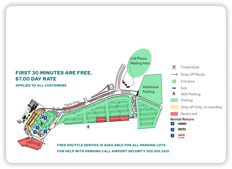
The rideshare pickup at OAK is on the 3rd Curb islands, specifically signed as Sections 3C2 through 3C9, reached by crossing outward from the Terminal 1 baggage claim doors. From the baggage claim exit, you do not stop at the first curb; you continue across two consecutive crosswalks to the outer island where the rideshare section markers begin.
The path is a three-stage curb sequence anchored on what you see immediately outside the doors. First, exit Terminal 1 baggage claim at ground level and face the nearest curb lane used for private vehicles. Second, use the first crosswalk to reach the middle island (the taxi/commercial shuttle curb). Third, take the next crosswalk to the outer island labeled as the 3rd Curb rideshare area, then walk along the island to the posted section range 3C2–3C9 that matches your app pickup instructions.
Where is the post-security decision point where signage first splits travelers toward lower-number gates versus 20+ gates, and what does the sign actually point to?
The first post-security split happens immediately as you exit the Terminal 1 TSA checkpoint into the secure concourse. At that exact fork, the primary overhead wayfinding directs you left/straight for Terminal 1 gates and sends you right toward the Gate 4 junction for the connector to Terminal 2’s higher-number gates.
The split is anchored by the flow geometry: passengers exiting the scanners naturally fan out, and choosing the wrong side forces immediate backtracking against cross-traffic. The left/straight channel feeds Gates 1–17 down the Terminal 1 pier, while the right channel points you toward Gate 4 and the post-security corridor that leads into Terminal 2 and Gates 20–32.
What is the shortest indoor walking route from Terminal 1 TSA exit to the Escape Lounge (used as a wayfinding anchor near Terminal 1 gates)?
The shortest indoor route to the Escape Lounge is a straight walk down the Terminal 1 concourse from the TSA exit toward the mid-pier gates, with the lounge located between Gates 8 and 8A across from Gate 9. From the checkpoint exit, stay left/straight into the main Terminal 1 pier rather than turning right toward Gate 4 and the Terminal 2 connector.
After you pass the Gate 4 area, continue along the concourse past the Gate 6 zone and the main retail/food area. The lounge entrance appears in the Gates 8–8A section, and the most reliable “you’re there” triangulation is seeing Gate 9 directly opposite the lounge frontage. Expect roughly a 3–5 minute walk depending on how crowded the Gate 6–8 pinch area is.
What is the exact walking distance from the Terminal 1 exit doors to the BART/OAK Connector boarding point, following the signed path?
The walking distance from the Terminal 1 exit doors to the BART/OAK Connector boarding point is about 300–400 feet, following the signed path across the roadway to the standalone station. The walk usually takes about 2–3 minutes at a normal pace.
From the Terminal 1 baggage claim exit, follow signs for the Oakland Airport Connector/BART and head straight toward the crosswalk that leads to the separate station building across the street. The key anchor is that the Connector station is not inside the terminal frontage—once you’ve cleared the curbside roadway crossing, you’re effectively at the station forecourt and can continue directly to the boarding entry.
Where is the closest restroom to the Terminal 1 TSA exit (first 60 seconds of walking), and which direction is it relative to the main flow?
The closest reliable restroom within about the first minute is at the Gate 3 area, reached by moving left/straight with the main Terminal 1 gates flow from the TSA exit. The Gate 4 women’s restroom closure makes the “turn right toward Gate 4” option a bad bet for immediate facilities.
From the checkpoint exit, follow the stream toward Gates 1–17 and aim for the Gate 3 node, which is the nearest dependable restroom anchor in that first-minute window. If you specifically need a women’s restroom and don’t see one immediately at Gate 3, continue down-pier toward the Gate 8/8A area near the Escape Lounge, where facilities are a more reliable fallback than the Gate 4 junction.
What is the shortest route from Terminal 1 ticketing to the lowest-number gate cluster, and which chokepoint or intersection controls that time?
The shortest route is Terminal 1 ticketing straight into the central Terminal 1 security checkpoint, then an immediate left/straight move after screening to the Gates 1 and 3 cluster. The chokepoint that controls the time is the security entrance merge where all queues compress at ID check, plus the instant post-TSA fork where a wrong turn forces backtracking.
From the ticketing lobby, aim for the main checkpoint (the one positioned before the concourse food/retail zone) and avoid drifting toward Gate 4 signage unless you’re intentionally heading to Terminal 2. After you exit the scanners, commit left/straight with the flow for Gates 1–17; Gates 1 and 3 are the first low-number gates you reach near the concourse root.
What is the walking distance from the furthest Terminal 1 gate area to the rideshare pickup location, measured on the terminal map?
Walking from the furthest Terminal 1 gate area (Gate 17) to rideshare at the 3rd Curb is about 1,300–1,500 feet total and usually takes 10–12 minutes. The route runs from the end of the Terminal 1 pier back to the security exit/baggage claim spine, then out to the outer curb islands.
From Gate 17, follow the concourse back toward the checkpoint root and exit the secure side to the baggage claim/arrivals level (this is the one-way “out” flow that prevents shortcuts back airside). Continue to the Terminal 1 baggage claim exit doors, then cross past the first curb and second curb to reach the rideshare island labeled 3rd Curb, where pickup zones are marked in Sections 3C2–3C9.