John Wayne Airport Terminal C Map (Most Up-To-Date)
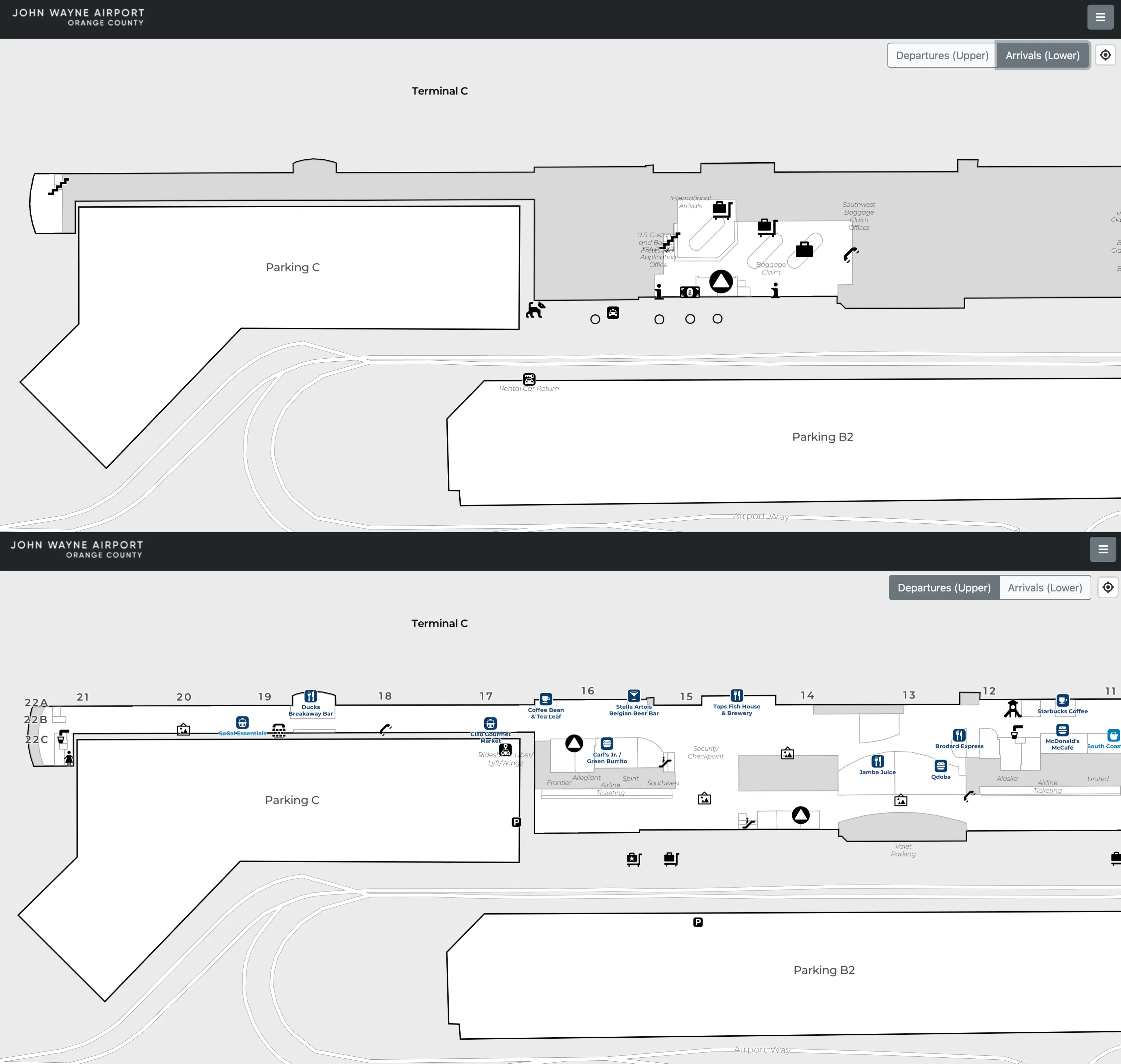
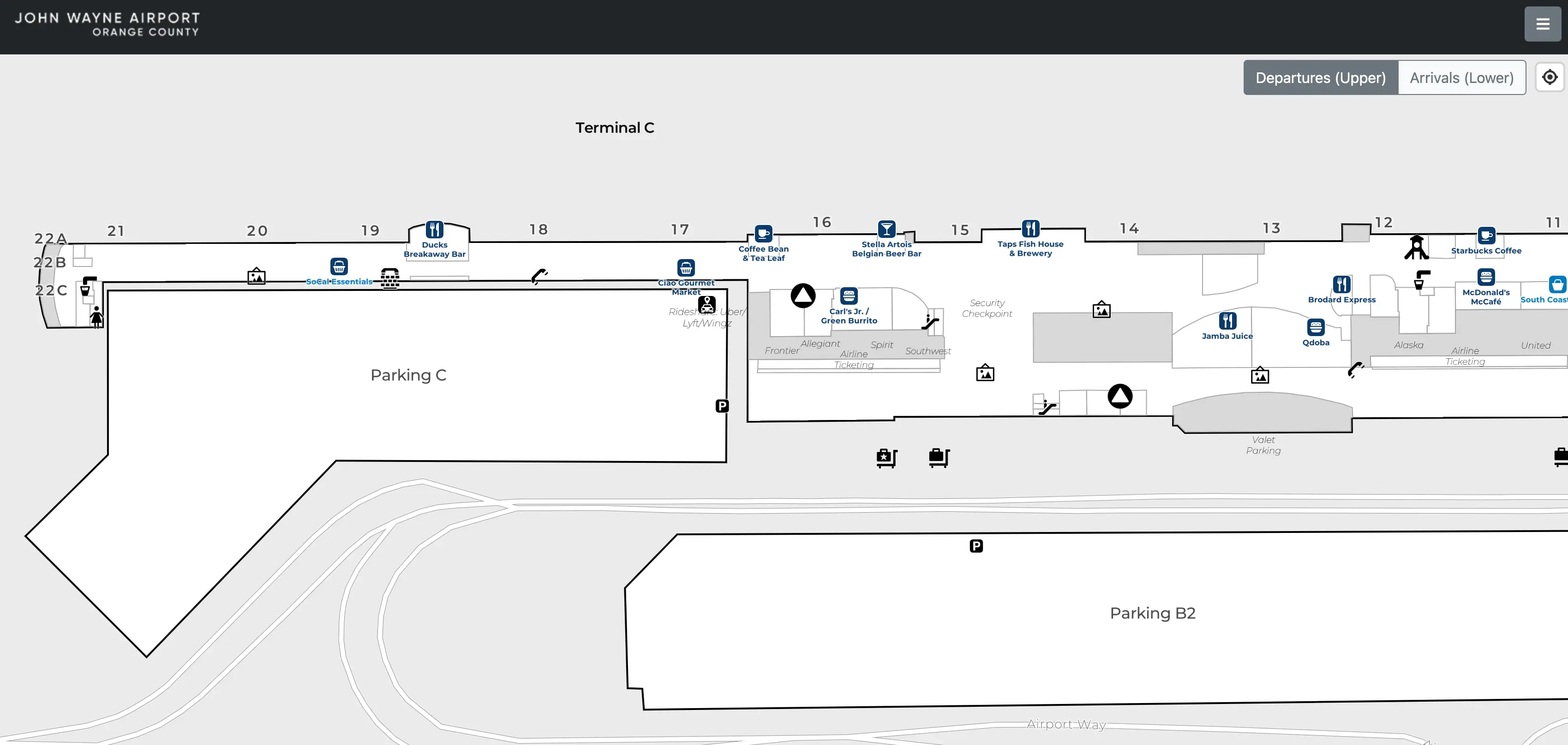
Terminal C at John Wayne Airport (SNA) is the south anchor of the Thomas F. Riley Terminal’s long, straight concourse, running north–south like a single continuous hallway within Orange County’s main airport hub. The secure side is one uninterrupted airside zone shared with Terminals A and B, so most “getting stuck” comes from choosing the wrong checkpoint, curb level, or parking-structure exit and then paying a backtracking penalty. Terminal C’s gates (16–22) stretch toward the far south end near the international/FIS area.
Map Table
| Zone | Connection | Walk Time |
|---|---|---|
| Airside junction | Terminal B gates 9–15 corridor | 4–5 min to Gate 18 area |
| Checkpoint C | Gates 16–17 side of concourse | 1–2 min to Gate 18 area |
| Far-south gates | Gates 21–22 end | 3–4 min from Checkpoint C exit |
| Parking Structure C bridges | Level 3 pedestrian bridge | 2–3 min to Southwest ticketing doors |
John Wayne Airport Terminal C Map Strategy
- Treat Terminal C delays as a mis-selection problem: wrong checkpoint, wrong curb/level, or wrong garage exit creates forced backtracking under boarding pressure.
- Use checkpoint-hopping correctly: the B↔C connection is a continuous airside corridor, so optimize your entry point first instead of “fixing it” after screening.
- Win the garage game: Parking Structure C Level 3 bridge access is the fastest geometry; avoid Level 1 “close spot” traps that add elevator waits and a punitive reroute.
- De-risk pickups: departures-level backups can make arrivals-level drop-off faster for reaching ticketing, while rideshare pickup is “up-and-over” into Structure C—know which baggage-claim doors put you closest to the correct elevator/bridge.
2026 John Wayne Airport Terminal C Map + Printable PDF
Printable planning for 2026 works best when it locks in the three “choice points” that create time loss at Terminal C: which checkpoint you clear, which curb level you enter, and which Parking Structure C pedestrian bridge/exit you take. Terminal C remains Southwest-dominant with gates 16–22, and the south-end arrivals/FIS functions can pull foot traffic toward the far end at peak times.
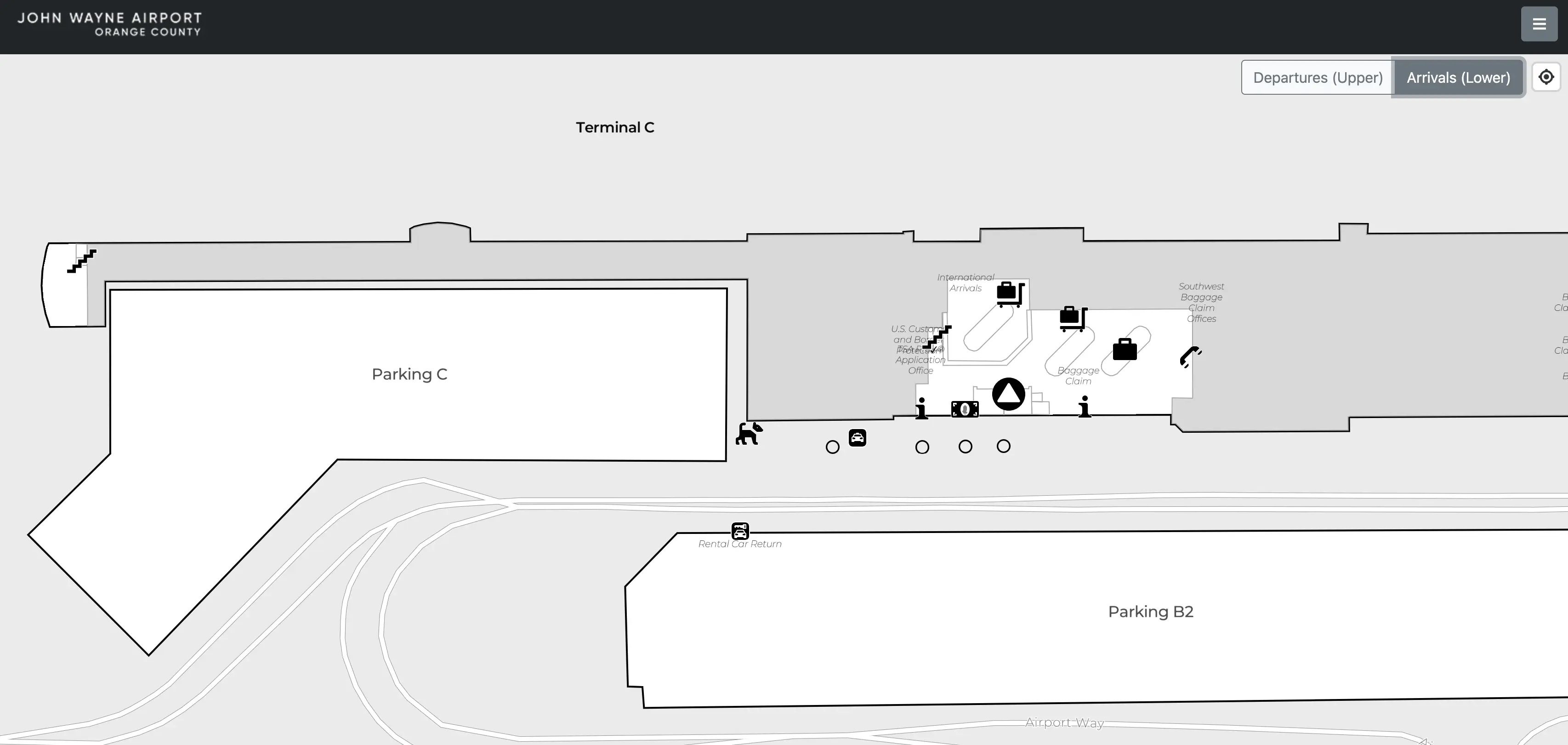
John Wayne Airport Terminal C Arrivals Map 2025
John Wayne Airport Terminal C Departures Map 2025
2026 John Wayne Airport Terminal C Guide
What is the exact airside walking distance (feet/meters) from Terminal B security exit to the nearest Terminal C gate corridor entrance (no re-screening route)?
The exact airside distance is the concourse hallway distance from the Terminal B post-security merge point to the first Terminal C gate corridor threshold (the Gate 16/17 area), with no re-screening anywhere along the route. Practically, this is the point where gate numbering transitions from B’s 9–15 into C’s 16–22 and the corridor widens into the Terminal C gate spine.
A usable wayfinding definition for “nearest Terminal C gate corridor entrance” is the first Terminal C decision node just past the Gate 15 area where Gate 16 signage becomes primary. The Deep Research you provided supports that the B→C path is fully continuous and typically takes about a 4–5 minute walk at normal pace, but it does not include a measured feet/meters value from airport geometry.
Does the B → C connector keep you fully airside the entire way, or is there any forced landside break that triggers re-clearing security?
The B → C connector keeps you fully airside the entire way, with no forced landside break and no requirement to re-clear security. The route is simply the continuous post-security concourse that runs south from Terminal B into the Terminal C gate spine.
Walking south from the Terminal B post-security area, you stay in the same sterile corridor past the Terminal B gate run (Gates 9–15) and continue into Terminal C as gate numbering shifts to Gates 16–22. The practical “handoff” landmark is the Gate 15/16 signage transition, not a door, bridge, or checkpoint. If you find yourself back at ticketing, curb, or a checkpoint queue, you’ve left the airside corridor and need to reverse course rather than “connector hop.”
From the Terminal C parking structure pedestrian exit, what is the shortest signed walking path to the Terminal C checkpoint entrance (name the exact corridor/bridge/door)?
The shortest signed path is the Parking Structure C Level 3 pedestrian bridge into the Departures/Ticketing level, followed by the straight interior walk to Checkpoint C on the same departures plane. Level 3 is the only bridge level, so it is the geometry that avoids elevator waits and avoids entering the terminal from the wrong floor.
From Parking Structure C, follow signs for the Level 3 pedestrian bridge into the terminal departures lobby adjacent to Southwest’s ticketing zone, then stay on the departures level and follow the overhead “Security” guidance to Checkpoint C. The key “do not lose time” landmark is staying on the Level 3 bridge alignment—if you enter from Level 1, you’ll be forced into the elevator core before you can reach the bridge, which is the common backtracking penalty that makes the walk feel unexpectedly long.
Which specific floor/exit point of the Terminal C parking structure delivers the shortest walk to Southwest check-in doors (identify the exact crossing point)?
Parking Structure C Level 3 delivers the shortest walk because it is the only level with a direct pedestrian bridge into the departures/ticketing lobby beside Southwest check-in. That bridge crossing is the “winning” exit point; anything else forces an elevator detour before you can even get onto the bridge.
The fastest pattern is parking on Level 3 and walking straight to the signed pedestrian bridge into Terminal C’s departures hall, exiting the bridge immediately adjacent to Southwest’s ticketing counters. If Level 3 is full, the roof level can still be fast by parking up top and walking down one flight to rejoin the Level 3 bridge alignment. The consistent wrong move is grabbing a Level 1 spot and then losing minutes to the elevator core before you reach the bridge.
Where is the fastest arrivals-level drop-off curb segment for reaching Terminal C ticketing, and what is the exact indoor route from that door to the escalators/elevators up?
The fastest arrivals-level drop-off is the Terminal C lower curb closest to the main Terminal C elevator/escalator bank serving the Carousel 5/6 doors, because it minimizes the indoor backtrack before you can go up to departures. Dropping at the far-south end near Carousel 7 tends to add extra lateral walking before you can climb to ticketing.
| Step | Route segment | Landmark triangulation |
|---|---|---|
| 1 | Stop at Terminal C Arrivals curb by the Carousel 5/6 sliding-door zone | Avoid the far-south international/Carousel 7 end |
| 2 | Enter through the nearest sliding doors into the Terminal C baggage hall | Visual target: Carousel 6 island |
| 3 | Turn toward the central vertical core and take elevator/escalator up one level | The “go up” move is the time-saver |
| 4 | Exit onto Departures/Ticketing and follow Southwest check-in frontage toward Security | Southwest counters are the immediate orientation anchor |
What is the minimum walk time from Terminal C curb (departures-level) to the Checkpoint C queue start, using the shortest door choice?
The minimum walk time is typically about 1–3 minutes from the Terminal C departures curb to the start of the Checkpoint C queue when you choose the closest departures-level door aligned with the security signage. The fastest result comes from entering through the doors that put you directly into the departures lobby flow toward “Security,” not through doors that funnel you into ticketing lines first.
The shortest path is a straight indoor push from curb → nearest departures doors → immediate “Security” wayfinding lane → Checkpoint C queue start, staying on the departures plane the entire time. The time-loss pattern is choosing a door that forces you to cut across the Southwest ticketing frontage during a peak bank, which can add stop-and-go friction even though the raw distance is short. If you hit a stanchion maze or need to reverse course, you picked the wrong door/aisle.
If PreCheck is consolidated to Terminal C, what is the exact walking distance from Delta/Terminal A-B-side gates to the Terminal C PreCheck entry?
Reaching Terminal C PreCheck from Delta’s Terminal A/B gate area requires going landside and re-clearing security, because PreCheck entry is before screening. Staying airside, you can already walk A/B ↔ C without any checkpoint, so the only reason to “go to PreCheck” is if you intentionally exit the sterile corridor and re-enter.
| Segment | What you do | Landmark triangulation |
|---|---|---|
| Delta gates → nearest exits | Walk back toward the main A/B concourse exits | Gate 1–8 zone toward the A/B rotunda |
| Exit airside → landside ticketing | Leave the sterile hallway into the public departures hall | “Baggage claim / Exit” direction reverses you out |
| Landside traverse to Checkpoint C | Move south to Terminal C’s departures lobby security entrance | Southwest ticketing frontage is the orientation anchor |
What is the exact location (landmark + terminal-end) of the Terminal C rideshare pickup referenced as the “far end,” relative to Baggage Claim doors?
Terminal C rideshare pickup is “up-and-over” on the Departures side in Parking Structure C (Level 3), not on the arrivals curb outside the baggage-claim sliding doors. The “far end” phrasing maps to the structure-side pickup zone reached by going upstairs and crossing the pedestrian bridge, rather than walking farther down the curb.
From the Terminal C baggage hall, the clean landmark plan is to start at the Carousel 5/6 door area, find the nearest elevator/escalator bank, go up to Departures, then follow signs across the pedestrian bridge into Parking Structure C Level 3 where the TNC/Uber/Lyft pickup area is staged near the structure’s elevator core. If you step outside at Baggage Claim Door 6 and expect curb pickup, you’ll have to re-enter, go up, and cross—this is the common “I’m at the wrong place” penalty.
From Baggage Carousel 6, what is the shortest indoor route to the oversize baggage pickup area behind Carousel 6 (turn-by-turn landmarks)?
The shortest route is a direct cut to the rear wall behind Carousel 6, because the oversize return is positioned out of view from the normal “front edge” waiting line. The key move is to stop watching the belt and immediately scout the back side of the carousel island.
From Carousel 6, walk around the carousel to the side opposite the main passenger-facing edge where most people cluster, then continue straight to the rear wall behind Carousel 6 where the oversized baggage door/rack area is located. Use Carousel 6 itself as the anchor: if you can’t see the belt’s machinery housing because it’s blocked by the carousel body, you’re on the wrong side—keep circling until you’re behind it. The common wrong turn is lingering at the “head” of the carousel and waiting for oversized items to appear on the belt.
What is the measured walking distance from Terminal C Checkpoint C exit to Gate 18 area (use the airport’s gate-path geometry, not estimates)?
The distance is the straight concourse-walk from the Checkpoint C exit point (which deposits you near the Gate 16/17 side) to the Gate 18 holdroom zone along the Terminal C gate spine. Gate 18 sits as the central operational node in Terminal C, so the path is direct with no level changes.
The Deep Research you provided supports that this is a very short interior walk—typically about 1–2 minutes at normal pace—and that Checkpoint C exits into the Gates 16–17 vicinity with Gate 18 just beyond. However, the report does not provide an airport-geometry measured feet/meters value for Checkpoint C → Gate 18; it only supports the time band and the gate-relative placement (Checkpoint C near 16/17, Gate 18 central).
What is the measured walking distance from Terminal C Checkpoint C exit to the furthest Terminal C gate-number cluster (identify the endpoint gate you used)?
The furthest Terminal C endpoint is the Gates 21–22 cluster, with Gate 22 as the practical “end of line” reference at the far south end. The walking path is the single straight Terminal C corridor from the Checkpoint C exit near Gates 16–17 down to the Gate 22 holdroom area.
Your Deep Research supports a typical 3–4 minute walk from Terminal C security to the far end (Gate 22) and describes Gate 22 as the most isolated terminus, but it does not include a measured feet/meters geometry value from the checkpoint exit to that endpoint. Using the same report’s operational framing, Gate 22 is the correct endpoint gate to cite for “furthest gate-number cluster” in Terminal C.
What is the shortest indoor walking route from Terminal A security exit to Terminal C gates, and where are the two most likely wrong turns along that corridor?
The shortest route is the straight airside corridor: Terminal A post-security → past Terminal A concessions → through the A/B rotunda area → continue south down the Terminal B gate spine → continue into Terminal C as gate numbers shift to 16–22. It is a single continuous sterile hallway with no connector shuttle and no checkpoint break.
Two wrong turns cause the biggest time loss. The first is drifting into the Terminal B rotunda/food court circulation and getting pulled into the densest pedestrian queueing zone instead of staying on the main southbound gate corridor. The second is accidentally exiting airside into landside (toward ticketing/curb) while looking for “Terminal C” cues—if you see public lobby doors, escalators down to baggage claim, or checkpoint queue starts, you’ve left the sterile corridor and need to reverse immediately rather than “fix it” by re-entering.