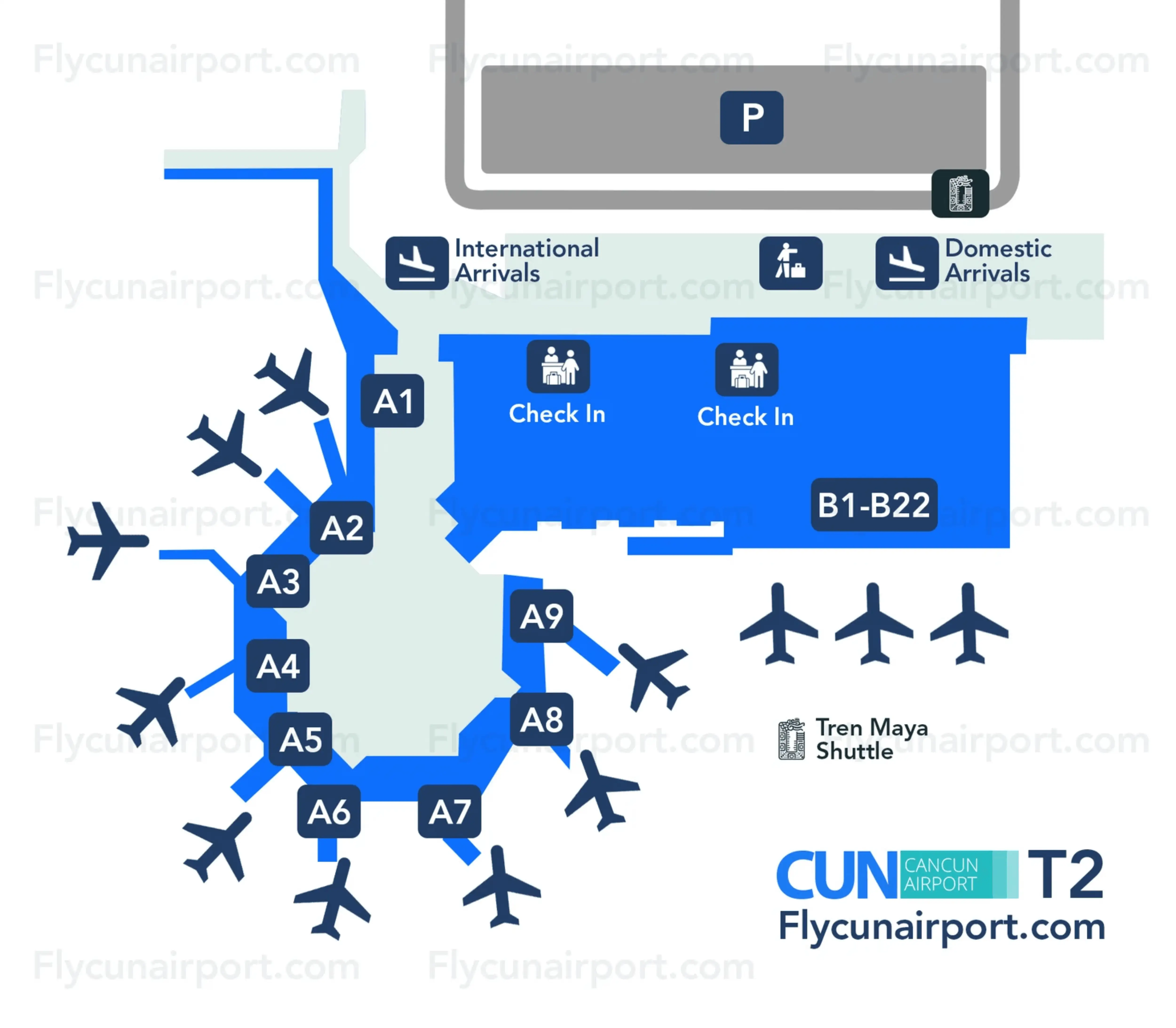
Cancún International Airport Terminal 2 Map (Most Up-To-Date)
Cancún International Airport Terminal 2 is a compact, legacy-style terminal with a mostly linear interior flow that compresses arrivals into a single landside exit corridor. The building’s “front” curb runs parallel to the access road, with transport pickup lanes and parking immediately outside the main sliding doors. Within Cancún’s main airport hub, Terminal 2’s key navigation challenge is the short post-customs funnel that forces a fast choice between staying inside (lobby amenities) or exiting to the curbside transport crowd.
Map Table
| Zone | Connection | Walk Time |
|---|---|---|
| Satellite Gates (A1–A11) | Pedestrian connector → Main Concourse | +10–15 min to immigration |
| Main Concourse (B12–B22) | Direct to immigration hall | 3–5 min to immigration |
| Baggage Claim | Customs checkpoint | 2–6 min |
| Post-customs corridor (“Shark Tank”) | Arrivals lobby → exit doors | 40–60 m |
Cancún International Airport Terminal 2 Map Strategy
- Treat baggage claim as the last “setup zone”: restroom, ATM, messages to your driver, then commit to a nonstop walk through the post-customs corridor toward daylight and the exit doors.
- Do not stop in the post-customs corridor—keep a straight line to the sliding glass doors; any sideways drift toward counters becomes a vendor funnel.
- For legitimate pre-booked transport, push past the first curbside cluster near the doors and verify greeters by making them say your name first, staying by the rope/barricade line until matched.
- For ADO buses, exit the building, turn right, and follow the sidewalk to the red ADO signage by the commercial vehicle bays; prioritize the outside bus-side kiosk/loading area over indoor lines.
2026 Cancún International Airport Terminal 2 Map + Printable PDF
Terminal 2 remains fully operational in 2026 as CUN’s higher-friction, older terminal, with arrivals still funneled through a single post-customs corridor into the public/transport interface. Automated immigration tools and phased customs modernization reduce some queue pressure, but they don’t change the core layout: baggage claim is the last calm checkpoint, and the curbside decision zone outside the sliding doors is still the primary stress point for pickups, buses, and transfers.
2026 Cancún International Airport Terminal 2 Map Guide
What is the exact walking route (turn-by-turn landmarks) from Terminal 2 baggage-claim exit to the official ground-transport pickup zone used by pre-booked shuttles?
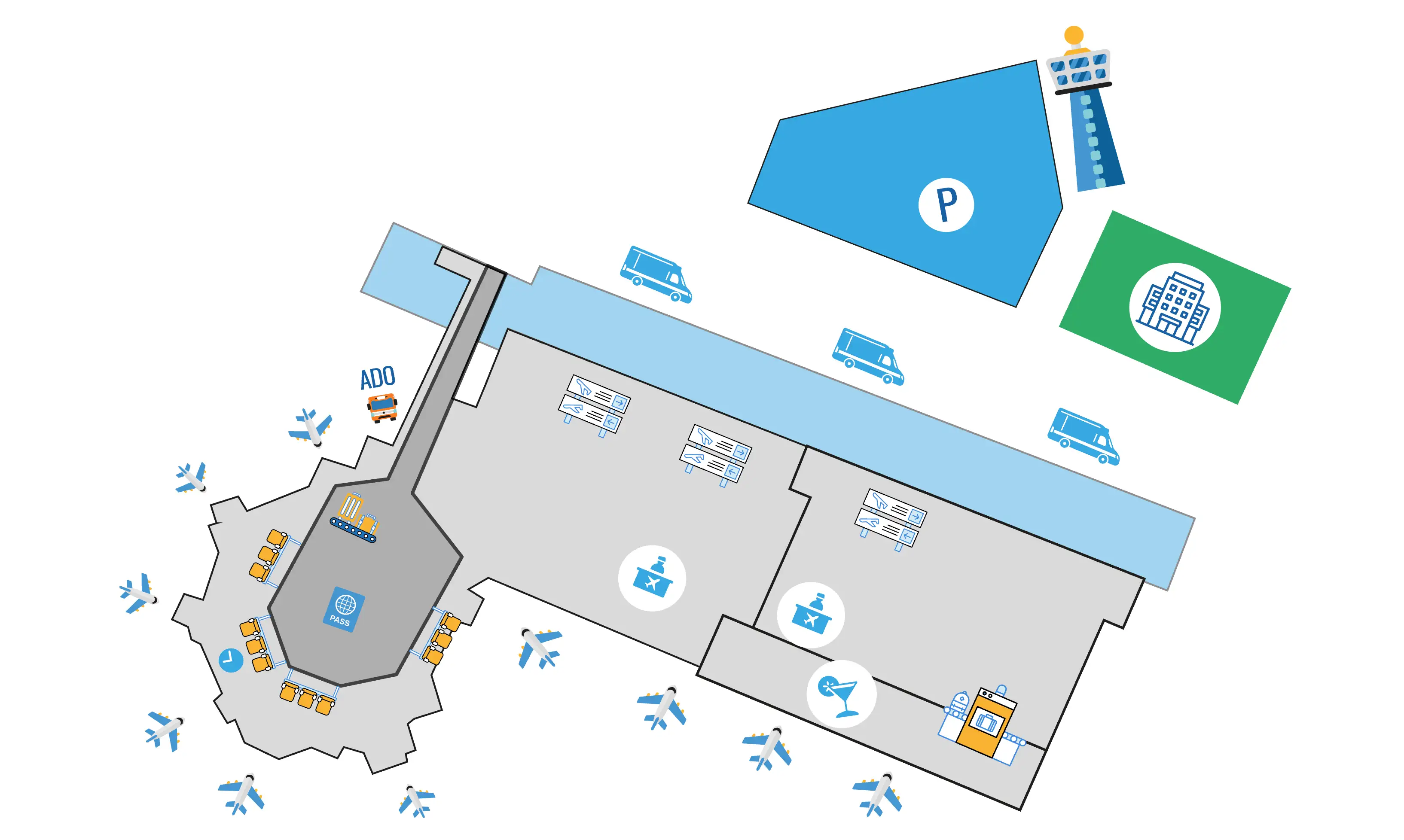
The official pre-booked shuttle pickup zone is outside Terminal 2’s main sliding glass exit doors at the curbside rope/barricade line where greeters hold signs. From baggage claim, walk to customs, then continue straight through the post-customs corridor without stopping until you reach the arrivals lobby and the exterior doors.
Exit the baggage hall into the customs checkpoint area and complete the customs screening. Continue forward into the short post-customs corridor and keep a straight line toward the natural light ahead, ignoring any “validation” or “information” hails along the sides. Enter the arrivals lobby, stay on the same forward heading to the main sliding glass doors, step outside, and stop at the rope/barricade line—this is the controlled meeting strip for pre-booked transport greeters.
Where is the first unavoidable “decision split” point after Terminal 2 customs (the point where travelers get funneled toward vendors), and what alternate corridor/door bypasses it?
There is no legitimate alternate corridor or door that bypasses Terminal 2’s post-customs solicitation corridor; the dealbreaker is stopping, not choosing a different passage. The first unavoidable decision split happens immediately after you clear customs and enter the short hallway where agents try to pull you sideways toward “validation” counters instead of the exit.
The funnel starts the moment you pass the customs officer and the one-way glass doors and step into the 40–60 meter corridor with people positioned along the left and right edges. The only correct “branch” is the forward vector: keep your eyes on the daylight and the sliding glass exit doors ahead. Any left/right deviation toward clipboards, desks, or “information” talk becomes the vendor lane; the functional bypass is staying centered and moving continuously into the arrivals lobby, then straight out to curbside.
Where is the free inter-terminal shuttle stop closest to Terminal 2 arrivals, and what is the walking distance in meters from the arrivals exit to that stop?
The free inter-terminal shuttle stop is outside Terminal 2’s main arrivals sliding doors, marked by a small vertical “Inter-Terminal Shuttle” sign along the curbside bus/van lane. Walking distance from the arrivals exit doors to the stop is about 70 meters.
Exit Terminal 2 through the main sliding glass doors to the curbside rope/barricade line, then angle toward the roadway side (not into the parking rows). Walk along the sidewalk parallel to the pickup lanes until you see the modest vertical shuttle-stop sign (often partially blocked by vans). This is the ASUR-branded shuttle pickup point for T1–T2–T3–T4.
What is the exact walking path between Terminal 2 and Terminal 3 (including the correct side of the road), and what is the distance in meters?
Walking between Terminal 2 and Terminal 3 is a dealbreaker in heat and traffic for most travelers with luggage, even though it is technically doable on sidewalks. The mapped walk is roughly 600–800 meters, staying on the terminal-front sidewalk on the same side as the terminal buildings.
Exit Terminal 2 to the curbside frontage and turn left, keeping the terminal building on your right and the pickup road on your left. Follow the continuous sidewalk that runs parallel to the access road, passing the curbside pickup lanes and vehicle areas without crossing into the road. Continue along the terminal frontage until Terminal 3 signage and entrances come into view, then stay on that same sidewalk to Terminal 3’s curbside doors. Avoid cutting through parking lanes or attempting to cross the active service road with bags.
From Terminal 2 arrivals, what is the exact location of the ADO bus ticket counter relative to the arrivals doors (e.g., outside Door X / left/right), verified on a map?
The primary ADO sales point for Terminal 2 is outside the terminal, to the right of the main arrivals sliding doors, near red ADO signage by the commercial vehicle/parking bays. From the doors, the correct vector is exit the building, turn right, and stay on the sidewalk past the private shuttle greeter area toward the parking/coach area.
Terminal 2’s ADO setup functions differently than Terminals 3 and 4 because the operational node is not a prominent indoor counter. The fastest way to “verify” you’re in the right place is visual triangulation: you should see red ADO branding and large red/silver coach buses staged in the outer lanes rather than the immediate curb lane. If you’re still inside staring at small counters and lines near arrivals, you’re not at the most useful ADO point for boarding.
From Terminal 2 arrivals, what is the walking distance from the arrivals exit to the ADO bus loading bay (not the counter), measured on the map?
Walking distance from Terminal 2’s main arrivals exit doors to the ADO bus loading bay is about 100–150 meters to the right along the curbside sidewalk. The loading position is typically in the second or third lane of the commercial vehicle bays, not the immediate curb lane.
Exit through the main sliding glass doors, turn right, and follow the sidewalk parallel to the pickup lanes past the densest greeter cluster. Keep moving toward the parking/coach area until red ADO signage and the staged coach buses are visible; the bus noses are usually set back where wide turns are possible. The practical “arrival” landmark is when you can see the large red/silver coach and a staff member handling luggage or calling destinations near the bays.
Where are the official taxi booths / fixed-rate counters located in Terminal 2 relative to the arrivals exit, and what is the shortest map-verified route to reach them without detouring past vendor lines?
The official fixed-rate taxi booths (“Taxi Seguro”) are positioned in the arrivals lobby area just after the post-customs corridor, before you fully commit to the curbside crowd outside the sliding doors. The shortest route is straight through the corridor to the arrivals lobby, then stop at the clearly marked taxi counter in the lobby area without drifting toward any “validation” desks in the corridor itself.
From customs, keep a direct forward line through the 40–60 meter post-customs hallway to the arrivals lobby. Once the space opens up into the lobby (with legitimate amenities like car rental desks and food outlets), scan for the official taxi booth branding and posted zone-rate boards rather than people with clipboards. Buy your ticket there, then proceed straight out the main sliding doors to the curbside pickup area; ignore anyone trying to intercept you between the doors and the rope line claiming to “help” with taxis.
Where is the closest indoor waiting area in Terminal 2 where someone can wait safely without re-clearing any checkpoint, and where is it located on the terminal map?
The closest safe indoor waiting area is the post-customs arrivals lobby seating zone near the legitimate car-rental counters and food outlets, before the exterior sliding doors. This space stays landside, requires no re-clearing of security, and is separated from the highest-pressure solicitation corridor behind you.
After clearing customs, walk through the short post-customs hallway into the wider arrivals lobby and stop there rather than exiting to the curb. Use nearby landmarks to anchor your position: car-rental brand counters (Hertz/Avis-type desks) and the small food/beverage outlets in the same open lobby area. If you need to regroup, this is the “cooling off” zone: air-conditioned, with seating, and with quick access back toward restrooms/ATMs in the lobby footprint without entering the curbside crowd.
Where is the nearest restroom to the Terminal 2 “exit to transport” funnel point (the spot scammers congregate), and what is the shortest mapped route to it?
The nearest reliable restroom is inside the arrivals lobby immediately after the post-customs corridor, before you exit through the main sliding doors to the curbside crowd. The shortest route is to clear customs, move straight through the corridor into the open lobby, then turn toward the lobby-side restroom signage rather than stepping outside.
If the post-customs corridor is congested or you want to avoid the densest solicitation moment entirely, the better restroom play is earlier: use the baggage-claim restrooms before customs, because that area is the last calm zone and you cannot return once you cross the one-way threshold. For a “right now, post-customs” option, enter the arrivals lobby and follow restroom icons within that open space near the legitimate services cluster (car rental desks/food counters), staying indoors and away from the exterior door bottleneck.
If you must do a terminal transfer for a tight connection, what is the fastest mapped path from Terminal 2 arrivals exit to the inter-terminal shuttle (pure distance/time), excluding any vendor aisles?
Walking straight out of the main sliding doors and immediately committing to the curbside sidewalk is the fastest path, because it avoids the post-customs corridor’s sideways vendor pull. The shortest transfer line is about 70 meters and typically takes 1–2 minutes at a brisk pace.
Exit Terminal 2 through the main arrivals sliding doors, do not stop at the rope-line greeter crowd, and angle toward the roadway side of the curb area. Turn in the direction of the terminal-front sidewalk (parallel to the pickup lanes) and follow it until you reach the small vertical “Inter-Terminal Shuttle” sign where the ASUR shuttle bus stops. Ignore anyone offering a “quick shuttle” or claiming the free shuttle is not running; the only objective is the marked stop on the curbside lane.
Where is the closest ATM to Terminal 2 arrivals that is before the main transport crowding point, and what is its map-verified position relative to the exit doors?
The closest ATM position that stays before the curbside transport crowd is inside the post-customs arrivals lobby near the legitimate services cluster, not outside by the rope line. Relative to the exit doors, the ATMs are inside the building just before the main sliding doors, positioned within the lobby footprint where car rental counters and food outlets sit.
To reach it with minimal friction, clear customs, move straight through the short corridor into the open arrivals lobby, and look for bank-branded machines (Santander/Banorte-type) along the lobby walls. Use the lobby as your boundary: once you step through the sliding doors to the curb, you’re in the highest-clutter pickup zone. If you need cash, withdraw here, decline dynamic currency conversion on the screen, then exit only when you’re ready to go directly to your transport plan.
Where is the closest airport hotel entrance that’s walkable from Terminal 2, and what is the map-measured walking distance from Terminal 2 arrivals to that entrance?
A truly “walkable” on-airport hotel entrance from Terminal 2 is not a reliable Terminal 2 feature; the practical hotel access from T2 is typically via shuttle/vehicle rather than a short, signed pedestrian hotel doorway. The only consistently walkable targets from Terminal 2 are other terminals along the terminal-front sidewalks, not a dedicated airport-hotel entrance.
If you need an on-foot solution, the safest “walkable” move is to take the free inter-terminal shuttle from Terminal 2 to the terminal that directly serves your hotel/shuttle meeting point, then walk the final short segment on marked sidewalks. From Terminal 2’s arrivals doors to the shuttle stop is about 70 meters; using the shuttle avoids dragging luggage across exposed roads and parking lanes while you search for an entrance that may not be pedestrian-friendly from T2.
Archive Cancún International Airport Terminal 2 Map
Below are all historical map versions for Cancún International Airport. Each year includes the official map available for that period, presented as both WebP and PDF.
2024 Cancún International Airport Terminal 2 Map