Venice Marco Polo Airport Map (Most Up-To-Date)
Venice Marco Polo Airport is a single-terminal, rectangular, three-level building with a split frontage: road transport on the landside curb and lagoon transport via the Darsena docks reached by an elevated moving-walkway corridor. Passenger flows hinge on vertical moves (Ground ↔ First floor) and one long intermodal spine to the water. Within Venice’s main airport gateway, your biggest wins come from choosing the correct level early and committing to the right exit-to-mode path.
Map Table
| Terminal | Key Airlines | Primary Function | Transfer Mode |
|---|---|---|---|
| Single terminal, Levels 0–2 | British Airways, Lufthansa, easyJet, Ryanair, Delta/American/United | Arrivals + baggage, split check-in, main security, passport control | ATVO/ACTV bus, land taxi, Alilaguna, private water taxi |
| Level 0 (Ground) | Ryanair, charter/overflow | Arrivals hall, baggage belts, curb exits, US-bound security | Bus/taxi curb, lifts/escalators to Level 1 |
| Level 1 (First) | British Airways, legacy carriers | Main check-in, general security, walkway to docks | Moving walkway to Darsena |
| Level 2 (Second) | — | Lounges, dining | Escalators/elevators airside |
Venice Marco Polo Airport Map Strategy
- Commit to your mode early: buses and land taxis are a quick ground-floor exit, but boats require a Level 1 climb first, then the long moving-walkway run to the Darsena.
- Treat the Arrivals Hall as a fork: choosing the wrong curbside door can add friction and backtracking before you even reach ATVO/ACTV stops or taxi lanes.
- Budget for variance, not averages: cruise-bank spikes and understaffed counters can turn “fast” security/passport into the timeline killer, so build buffer before any last-boat or last-bus cutoff.
- For water transport, plan the “last-boat trap”: the walk + travelators + dock descent is a fixed distance, and missing a departure means a long wait in a dock environment with limited comfort.
2026 Venice Marco Polo Airport Map + Printable PDF
Current 2026 wayfinding still revolves around two “non-obvious” moves: going up to Level 1 to reach the water-transport walkway, and confirming whether your check-in/security is on Level 0 (US direct screening, some low-cost/overflow desks) or Level 1 (main departures). Cruise-day surges can amplify queue variance at check-in, security, and passport control, so the map is as much about choke points as distances.
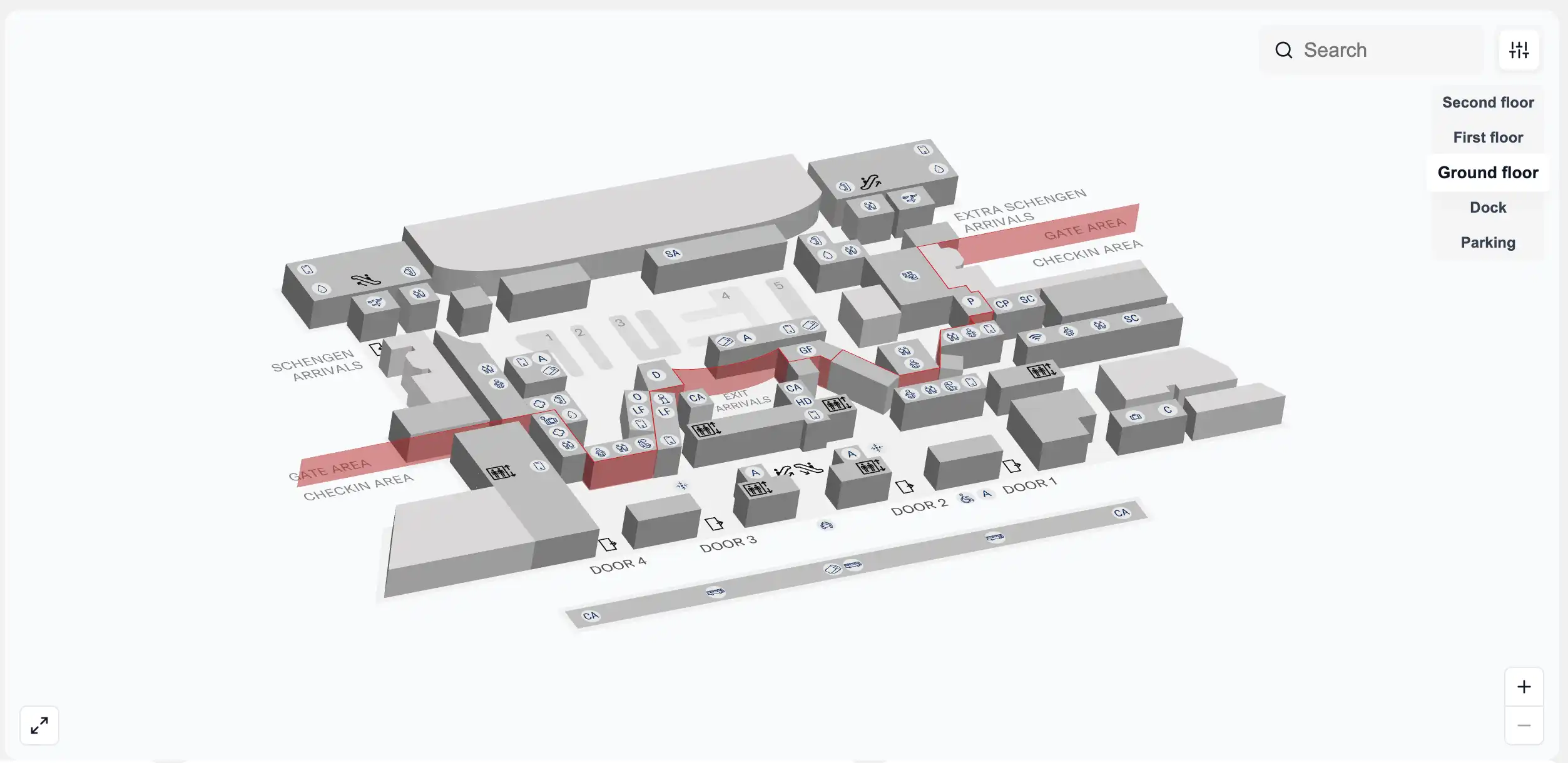
Venice Marco Polo Airport Ground Floor Map 2025
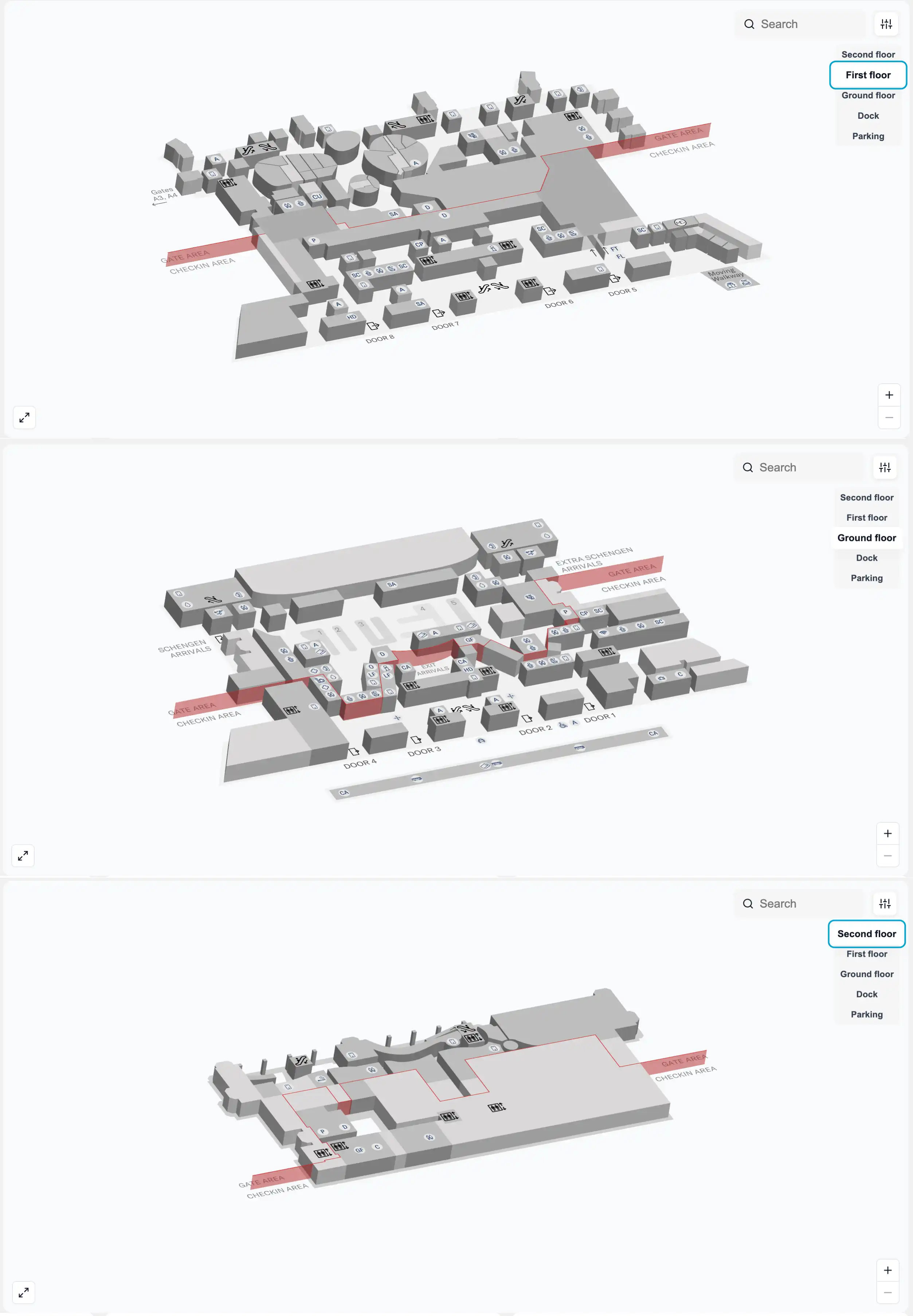
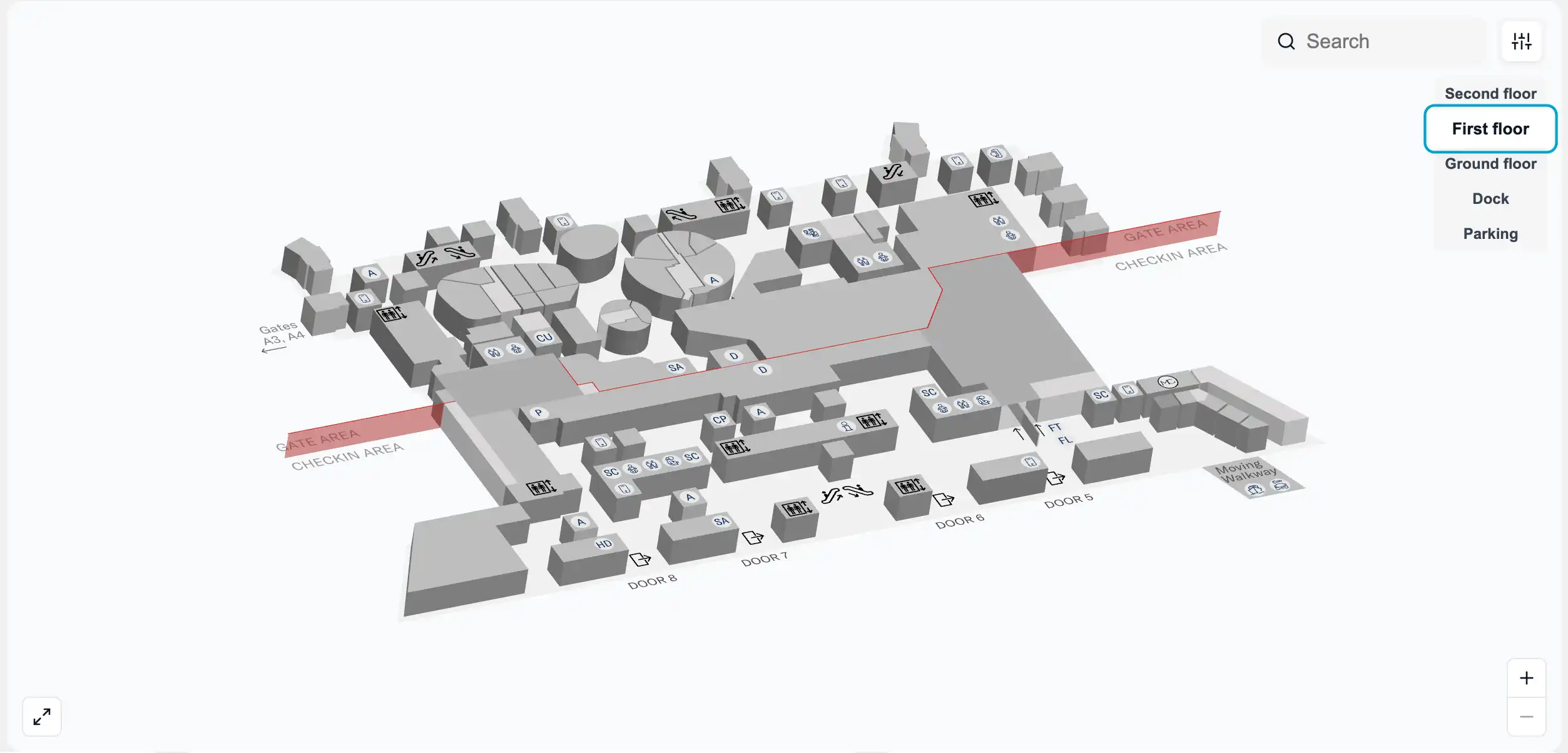
Venice Marco Polo Airport First Floor Map 2025
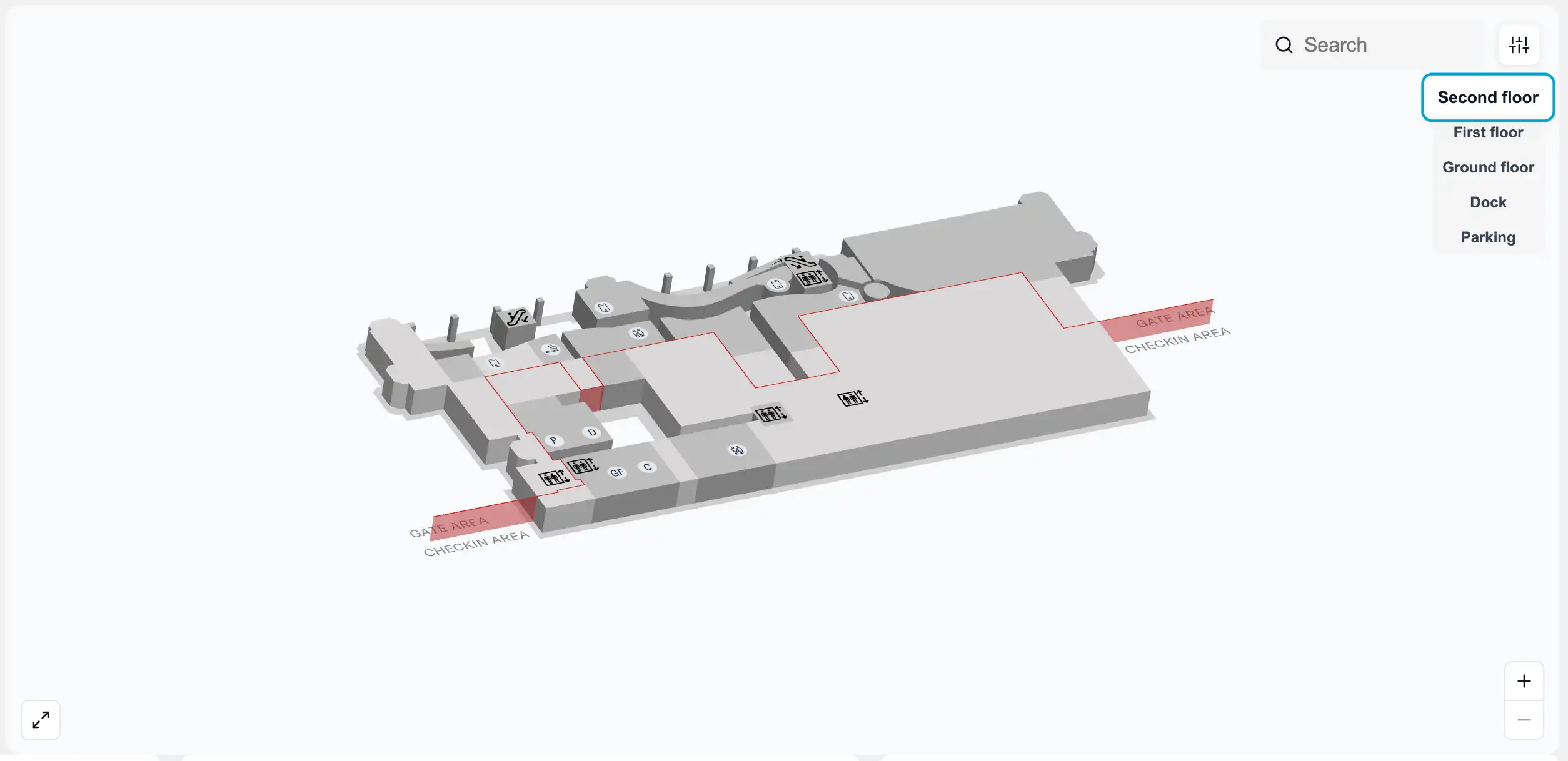
Venice Marco Polo Airport Second Floor Map 2025
2026 Venice Marco Polo Airport Map Guide
What is the exact walking distance (meters) and fastest indoor/outdoor path from Arrivals exit to the Alilaguna / water transport docks at VCE?
No tram or shuttle exists between Arrivals and the Darsena docks, so the route is a fixed walk that you must execute correctly via Level 1. The total walking distance from the Arrivals Hall to the water transport docks is about 800 meters, with the moving-walkway gallery itself about 365 meters.
Arrivals Hall (Ground Floor) reaches the docks fastest by going up before you go out. Exit baggage/customs into Arrivals Hall, follow blue “Water Transport” signage to the lifts/escalators, go up to the First Floor walkway entrance, then stay in the enclosed elevated corridor with travelators until the ticket booths at the Darsena. The corridor ends at the covered dock basin; the final descent to pontoons is via ramps/steps beside the ticket area.
Where is the precise curbside pickup point (door number / lane) for ATVO buses at Venice Marco Polo Airport, and what is the walking distance from baggage claim to that stop?
ATVO buses use the bus station reached via Exit D, in the second lane outside the terminal, not the first curb lane. The walking distance from baggage claim area to the ATVO stop is about 50 meters to Exit D plus a short curb crossing of about 20 meters to the bus lanes.
| Segment | Route nodes | Distance |
|---|---|---|
| Baggage belts → Exit D | Baggage claim → Arrivals Hall → Exit D | ~50 m |
| Exit D → ATVO platforms | Sidewalk → crosswalk over first lane (taxis/drop-offs) → bus station (2nd lane) | ~20 m |
| Where to board | Bus station | Platforms 3–4 area (ATVO/ACTV depending on destination) |
From the ATVO/ACTV drop-off area, what is the exact walking route and distance to the primary security checkpoint entrance used for departures?
The primary departures security checkpoint is on the First Floor near Entrance 5, so the shortest route from the ATVO/ACTV bus area is a straight curb-to-terminal entry and then an immediate climb to Level 1. The walk is about 100 meters from the bus drop-off area to the First Floor departures/security zone, assuming you don’t detour through the Arrivals hall.
From the bus station, cross back over the marked crosswalk to the terminal frontage and enter through the central frontage doors closest to the “Departures” ramp/escalators. Go up to the First Floor (Departures Hall), then follow the central flow toward Entrance 5 where the main security queuing area starts. If you find yourself among baggage belts or customs exits, you came in too far into the Arrivals side—backtrack to the central vertical cores and go up before committing to a long indoor walk.
Inside Venice Marco Polo Airport departures, where is the British Airways (or other non-Schengen carrier) check-in desk zone located (hall/row), and what is the walking distance from the main entrance?
British Airways check-in is on the First Floor departures hall in Section B within the desks numbered 1–56. Walking distance from the main First Floor departures entrance to the BA desk islands is about 100 meters.
The First Floor is the “main” check-in level for legacy and non-Schengen carriers, with desk islands arranged in linear rows facing the frontage. British Airways typically sits in the Section B area of that 1–56 desk range, close to the central flow toward Entrance 5. Use Entrance 5 as your landmark: stand with the security direction ahead of you, and the BA/legacy desk islands are in the same departures hall zone, reached without dropping down to Ground Floor.
What is the exact route and walking distance from the main security exit to the passport control / non-Schengen processing point (the last checkpoint before non-Schengen gates)?
Passport control for non-Schengen flights is a post-security checkpoint reached after the duty-free corridor, so you cannot skip it if your gate is in the non-Schengen zone. The walking distance from the main security exit to the passport control point is about 400 meters, depending on how far you must traverse through the central airside retail stream.
After clearing main security on the First Floor, continue straight into the Schengen airside concourse and follow signs for non-Schengen departures (UK/UAE/other non-EU). Use the duty-free area as the triangulation landmark: the route passes through/along the duty-free run before funnelling into the Italian Border Police checkpoint. If you reach gate corridors without a border-control pinch point, you are still in the Schengen side—turn back toward the duty-free spine and follow “Non-Schengen / Passport Control” signage.
Where are the e-gates located relative to the manual passport desks, and what is the minimum walking distance between them?
E-gates sit in the same passport control zone as the manual stamping booths, positioned as an adjacent lane set that you can switch to only if you spot them before committing deep into the staffed queue. The minimum walking distance between the e-gates and the manual desks is effectively a few meters—about 5–10 meters across the same border-control frontage.
In practice, the decision point is at the head of the passport-control approach where the queue splits. Look for the e-gate bank beside the staffed booths and pivot immediately if eligible (biometric passport, age rules as posted). If you snake far into the manual queue, it becomes awkward to exit without losing your place, so scan for the e-gates as soon as the checkpoint comes into view.
What is the shortest, step-by-step path (with landmark nodes) from baggage belts to the bus ticket machines / sales point used for ATVO/ACTV tickets?
ATVO/ACTV ticket machines are located before you fully commit to the curb exits, with machines available in the baggage claim area and again in the Arrivals Hall. The shortest path is to buy in the baggage-claim/arrivals interior zone, then walk straight out via Exit D to the bus platforms.
From the baggage belts, walk toward the Arrivals Hall opening and look for the ticket machine cluster in the baggage-claim side before the public curb doors. If you miss those, continue into the Arrivals Hall and use the machines there, then immediately triangulate on Exit D for the bus station. Exit D puts you closest to the bus lanes; once outside, cross the first lane (taxis/drop-offs) at the marked crosswalk to reach the bus platforms in the second lane.
Which terminal doors/entrances are physically accessible during very early hours, and where are they located on the frontage map (so passengers don’t wait at a closed façade)?
Terminal access is effectively constrained until the building opens around 04:00, so arriving earlier can leave you outside regardless of which façade door you choose. The practical early-hours rule is to target the central frontage doors aligned with the main departures access and the vertical cores, because side sections may be closed or minimally staffed.
The most reliable early-hours access is the main central entrance zone that feeds the First Floor departures hall (the same frontage band used for the primary security flow near Entrance 5). If you are heading for US direct security, the landside approach needs to be toward the far east side near Entrance 8 once doors are open, but the “show up before opening” failure mode is still the same—plan arrival for after the published opening window to avoid waiting at a closed frontage.
Where is the Fast Track lane entrance located on the departures map, and what is the distance from standard security queue start to Fast Track entry?
Fast Track is at the main First Floor security checkpoint near Entrance 5, positioned as a separate lane on the left side of the general security lanes. The distance from the start of the standard security queue to the Fast Track entry is short—typically about 10–20 meters within the same queuing apron.
Use the Entrance 5 security hall as the landmark: when you face the screening lanes, the Fast Track access is the distinct left-hand channel signed for eligible passengers and pre-purchased access. The key timing risk is not the walk but the commitment—spot the Fast Track signage before you join the main serpentine, because re-cutting across once you’re deep in the standard queue is socially and physically difficult.
Post-security, where are the last reliable food and water points BEFORE passport control, and what is the walking distance from security exit to each?
The last reliable food and water options before passport control are in the Schengen airside concourse immediately after main security, because the non-Schengen zone beyond passport control has far fewer choices. From the security exit, the main cluster is within roughly 50–150 meters depending on which outlet you choose.
Use the central post-security retail spine as your anchor: shops and cafés sit along the Schengen side before the duty-free/passport-control funnel. Typical last-stop picks include the main bar/café nodes (for example, Bricco and nearby counters) and nearby water sources by restrooms along that same post-security corridor. Once you commit to the “Non-Schengen / Passport Control” flow, expect fewer options, so buy water and food on the Schengen side first while keeping an eye on the passport queue length.
For late arrivals trying to make the last boat: what is the fastest mapped path from aircraft gate corridor to arrivals exit to docks, and what is the minimum realistic walking time (excluding queues)?
The fastest gate-to-dock path takes about 18 minutes of continuous walking if you skip stops and don’t face elevator congestion. No shuttle or tram exists between the terminal and the Darsena, so the critical path is fixed and punishes wrong-level routing.
| Leg | Landmark nodes | Distance / time |
|---|---|---|
| Gate corridor → Arrivals flow | Gate corridor → follow “Arrivals / Baggage claim” stream → customs exit into Arrivals Hall (Ground Floor) | ~6–8 min |
| Arrivals Hall → Walkway entrance | Arrivals Hall → blue “Water Transport” signs → lifts/escalators up to First Floor | ~2–3 min |
| Walkway run → Darsena | First Floor moving-walkway entrance → enclosed travelator gallery → ticket booths at Darsena | ~365 m corridor; ~10–12 min brisk |
| Ticket area → pontoons | Ticket booths → descend via ramps/steps to the assigned slip | ~1–2 min |
From non-Schengen gates, what is the longest walking distance to the farthest gate cluster, and which gate numbers define that farthest cluster?
The longest walk within the non-Schengen side is typically to the remote/bus-gate cluster around Gates 42–49, at roughly 300–400 meters end-to-end depending on the exact corridor routing. That cluster is the usual “farthest edge” compared with the closer gate positions immediately after passport control.
After passport control, the flow rejoins the main airside spine and then branches toward numbered gate corridors. Use the passport-control exit and the duty-free spine as your anchor points: if you’re still passing dense retail and central seating, you’re not yet in the far gate run. Gates 42–49 are commonly associated with bus-gate operations, so factor in extra time for the down-to-bus-gate descent and early boarding cutoffs.
Where is the taxi rank exactly located on the landside map, and what is the walking distance from both arrivals exit and departures entrance to that rank?
The taxi rank is in the first curb lane directly outside the Arrivals exits on the landside frontage. Walking distance is about 20 meters from the Arrivals exit doors to the taxi queue, and roughly 20–40 meters from the departures-side entrance area depending on which frontage door you use.
Land taxis stage immediately along the curb in the lane closest to the terminal sidewalk, with buses in the second lane beyond. If you see the bus platforms across a crosswalk, you’re oriented correctly: taxis are the near lane by the doors, buses are the far lane. For the fastest taxi pickup, exit the terminal and stay in the first lane’s marked taxi queue area rather than crossing toward the bus station.
Archive Venice Marco Polo Airport Map
Below are all historical map versions for Venice Marco Polo Airport. Each year includes the official map available for that period, presented as both WebP and PDF.
2018 Venice Marco Polo Airport Map