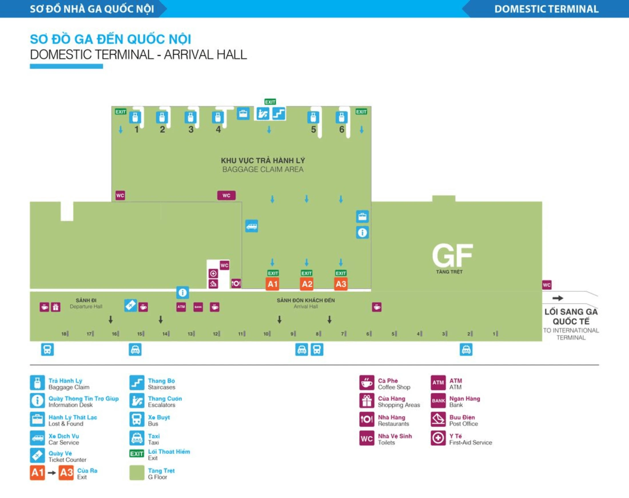
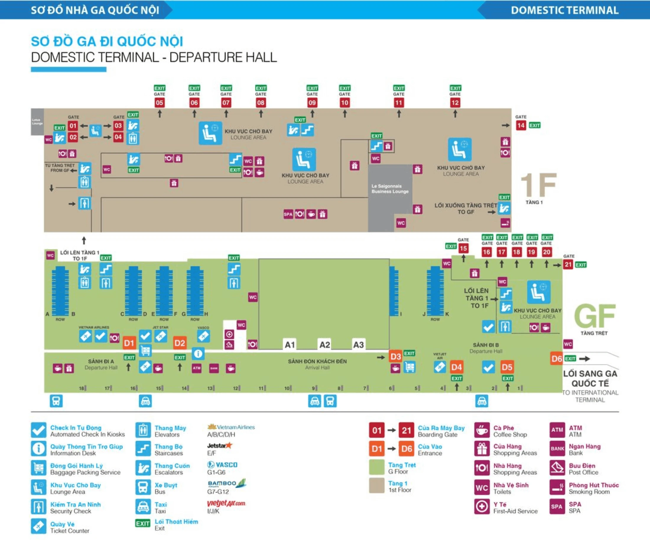
Tan Son Nhat International Airport Terminal 1 Map (most Up-To-Date)
Terminal 1 at the main Ho Chi Minh City airport hub is a linear, two-level domestic building with curbside doors spread left-to-right (D1–D6) and a single central spine for moving up to departures. Arrivals and check-in sit on the Ground Floor, while security and boarding gates are upstairs on 1F, so every departure requires a vertical transition after check-in. Most navigation errors start with using the wrong door and losing time crossing the hall against crowds.
Map Table
| Zone | Connection | Walk Time |
|---|---|---|
| Doors D1–D3 frontage | T2 covered walkway (near D1/D2) | 5–10 min to T2 exits |
| Ground Floor check-in hall | Escalators/stairs up to 1F security (central) | 2–6 min (queue-dependent) |
| Arrivals exit | TCP Park garage ride-hail pickup (Lane D1) | 5–12 min |
Tan Son Nhat International Airport Terminal 1 Map Strategy
- Enter by the correct door first: Door D1 aligns with Vietnam Airlines ATR72 regional routes, Door D2 is the central service node, and Door D3 is the Vietjet-heavy zone; the wrong door forces a long cross-hall push through queues.
- Convert the building into three “must-hit” nodes: your curb door → your check-in row zone → the central escalator/stair block to 1F security; don’t hunt for security on the ground floor because it isn’t there.
- Expect choke points to stack: check-in queues can spill toward the doors, then the escalator area compresses flows before security; pad time for that compression rather than assuming a smooth indoor walk.
- Lock in what’s not possible: there’s no airside transfer from international arrivals into Terminal 1’s domestic departure flow, and ride-hailing pickup is not at the curb—use the TCP Park garage Lane D1 to avoid losing time outside.
2026 Tan Son Nhat International Airport Terminal 1 Map + Printable PDF
Terminal 1 remains a high-friction domestic terminal in 2026, even after Terminal 3 opened, because it still handles dense low-cost volumes and select Vietnam Airlines regional ATR72 routes. Door choice still determines how clean your path is to the right check-in rows, and the biggest time swing inside Terminal 1 is check-in crowding followed by the upstairs security queue after you reach the central escalators.
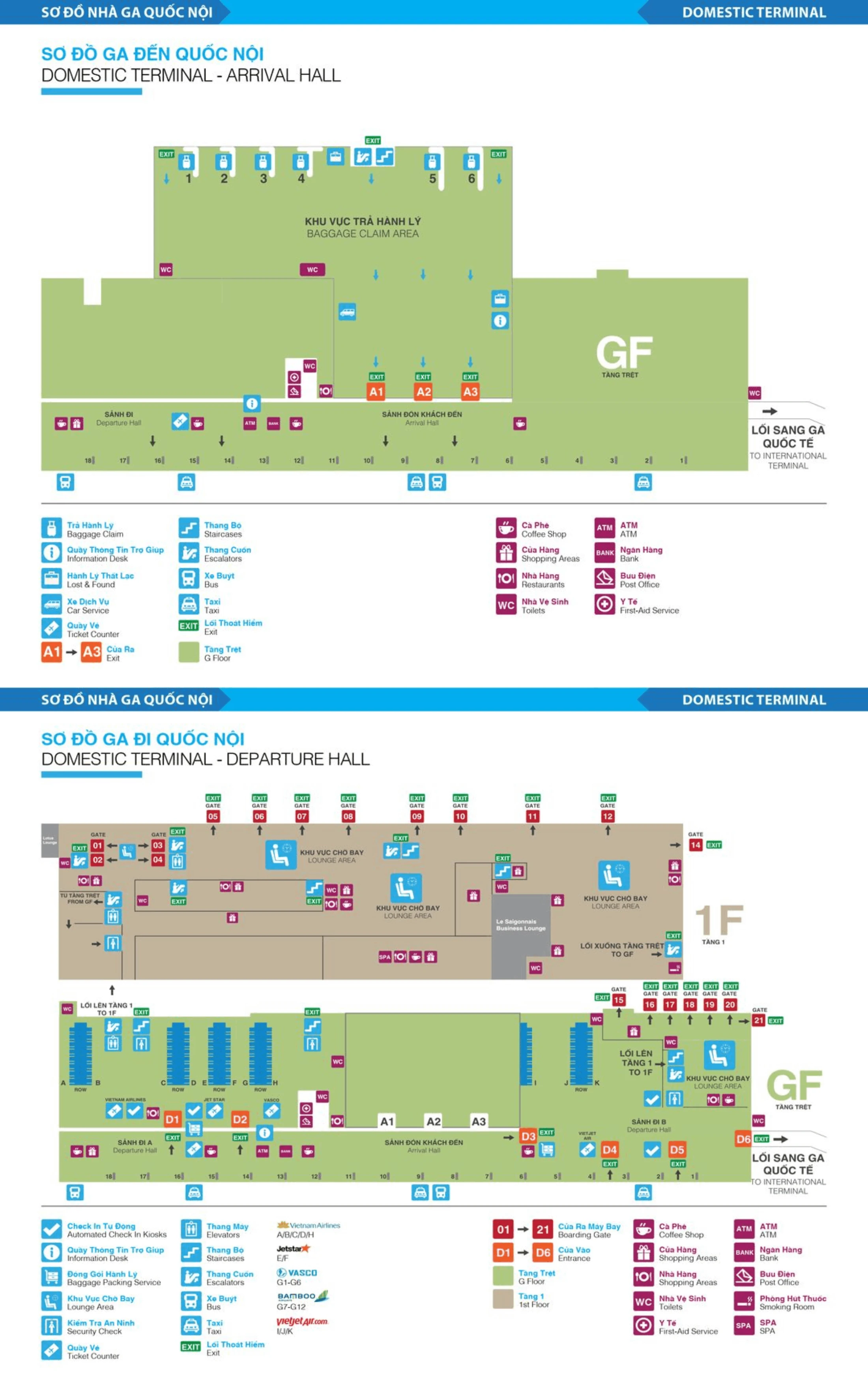
Tan Son Nhat International Airport Terminal 1 Domestic Arrival Map 2024-2026
Tan Son Nhat International Airport Terminal 1 Domestic Departure Map 2024-2026
2026 Tan Son Nhat International Airport Terminal 1 Map Guide
What is the exact walking distance (meters) from T1 Arrivals exit doors to the T2 International Departures entrance via the covered walkway?
Walking distance is roughly 450 meters door-to-door when you start at Terminal 1 Arrivals (ground floor) and finish at Terminal 2 Departures (Level 2) using the covered T1–T2 connector. The outdoors connector itself is the short part; the longer variable is getting from the T2 ground-floor arrivals frontage up to the departures-level entrance.
| Segment | Landmark anchors | Distance |
|---|---|---|
| T1 Arrivals exit → connector start | exit glass doors → frontage near Doors D1/D2 | ~80 m |
| Covered walkway | blue/metal-roof corridor between terminals | ~200 m |
| T2 ground level → T2 departures entrance | arrivals curb → escalator/elevator bank → departures-level entry | ~170 m |
| Total | T1 Arrivals doors → T2 Departures entrance | ~450 m |
Where is the precise map pin of the shuttle/bus stop used for terminal transfers when passengers are “taken to the terminal” after landing?
The terminal-transfer shuttle pickup is at the curbside column zones on the Ground Floor, not inside the halls. At Tan Son Nhat, the most consistent anchor for being “taken to the terminal” between the T1/T2 cluster and Terminal 3 is the shuttle bay at Terminal 2’s Ground Floor, marked by Column 12.
Use these curb anchors so a driver, staff member, or airport helper can take you to the exact spot:
- Terminal 2 shuttle stop: Ground Floor arrivals frontage, Column 12
- Terminal 1 shuttle stop: curbside bus cluster area, commonly signed near Column 18
- Terminal 3 shuttle stop: Ground Floor, Columns 18A and 19A
From T1 Arrivals curb, what is the exact walking distance (meters) to the domestic check-in hall entrance (the door you must use to avoid re-routing)?
Walking distance is about 60 meters from the Terminal 1 arrivals curb to the correct check-in hall entrance door if you enter at the nearest matching frontage door (typically near Doors D1/D2). The key is not the meters—it’s entering through the door aligned with your airline zone so you don’t get forced into a long cross-hall push.
| Segment | Landmark anchors | Distance |
|---|---|---|
| Arrivals curb → arrivals glass exit | curb edge → sliding glass doors | ~15 m |
| Exit → correct check-in entrance door | arrivals doors → Door D1/D2/D3 frontage entry | ~45 m |
| Total | curb → correct check-in hall door | ~60 m |
Where is the exact security screening entrance for domestic departures inside/adjacent to Terminal 1, and which side (left/right) do you approach from the check-in rows?
The domestic security screening entrance is on the first floor, immediately at the top of the central escalator/stair complex between the Ground Floor check-in row blocks around E/F and G/H. That security portal is not curb-adjacent and it isn’t on the Ground Floor.
Security is reached by walking from your check-in row toward the terminal’s central spine, then going upstairs via the main escalators/stairs (elevators are also nearby). From the check-in rows, the clean approach is from the middle aisle toward that central escalator block, then straight into the screening lanes at the top rather than trying to “hug” the far-left or far-right ends of the hall.
What is the exact path (named doors/landmarks) from T2 baggage claim exit to the T1 domestic airline check-in counters—what intersections/turns are required?
No airside transfer exists, so the path starts after customs and ends at the Terminal 1 landside check-in doors. The critical turn is outside Terminal 2: you must turn right and follow the covered connector toward Terminal 1 instead of crossing to the parking side.
| Step | Landmark anchors | Turn / intersection |
|---|---|---|
| 1 | T2 baggage claim → customs X-ray exit | straight into public Arrival Hall (A1/A2) |
| 2 | Arrival Hall doors A1/A2 → curb | exit to curbside frontage |
| 3 | curbside → Burger King | turn right, keep terminal wall on your right |
| 4 | Column 10 → doors G5/G6 | continue right to the connector start |
| 5 | covered walkway → Highlands Coffee | straight through the corridor |
| 6 | roadway crossing at T1 frontage | cross at the marked crosswalk (active taxi/private-car lane) |
| 7 | arrive T1 near Doors D1/D2 | enter for check-in rows; D1 for VNA ATR72 regional, D2 central, D3 Vietjet-heavy |
Where is the precise location of the Vietnam Airlines / Vietjet domestic relocation boundary (which terminal building is used for which airlines after T3 changes), as shown on the airport site map?
The relocation boundary is the terminal split itself: Vietnam Airlines’ mainline domestic operation moved to Terminal 3, while Vietjet’s domestic operation remains in Terminal 1. The decision point happens before you enter any building—at the curbside frontage where you choose which terminal doors to walk into.
- Terminal 3: Vietnam Airlines mainline domestic (jet aircraft routes like Hanoi/Da Nang/Nha Trang/Phu Quoc), Bamboo Airways domestic
- Terminal 1: Vietjet Air domestic, Pacific Airlines, Vasco, Vietnam Airlines ATR72 regional (Con Dao, Rach Gia, Ca Mau)
- Terminal 2: international flights (including Vietnam Airlines and Vietjet international)
What is the exact distance (meters) from the terminal-to-terminal walkway entry to the first domestic check-in counter zone in T1 (how far you still walk after reaching the building)?
Walking distance is about 90 meters from the covered walkway’s Terminal 1 end to the first check-in counter zone if you enter at the near-side doors by D1/D2 and head straight into the nearest check-in rows. If your airline’s counters are deeper toward the Vietjet-heavy end, the inside distance grows quickly because you’re moving along the full length of a crowded hall.
| Segment | Landmark anchors | Distance |
|---|---|---|
| Walkway end → T1 frontage doors | connector exit → Doors D1/D2 area | ~25 m |
| Doors → first check-in counter zone | entry → nearest check-in rows (A–F area) | ~65 m |
| Total | walkway entry point → first counters | ~90 m |
Where is the exact curbside pickup zone for ride-hailing (e.g., Grab) at Terminal 1, and which gate/door number corresponds to it on the terminal map?
Ride-hailing pickup is inside the TCP Park multistory garage opposite Terminal 1, not at the Terminal 1 curb doors. The usual Grab meeting area is labeled by the garage lanes and pillars, with the most-cited pickup lane being Lane D1.
Exit the Terminal 1 arrivals hall to the public frontage, then cross the internal roadway toward the TCP Park garage entrance near the Highlands Coffee area. Once inside the garage on the ground level, follow the Grab instructions to the lane/pillar coordinate shown in-app (examples often look like Pillar D5, F5, or K5). Terminal 1 door numbers (D1–D6) are building-entry markers, but they don’t function as the ride-hail pickup point the way the garage lane/pillar grid does.
What is the exact walking distance (meters) from T1 check-in rows to the correct departure gate corridor, including the nearest escalator/stair location?
Walking distance is typically 180–320 meters from the Terminal 1 check-in rows to the departure gate corridor because you must reach the central escalator/stair block, go up to 1F security, then continue left or right along the linear airside hall. The nearest vertical route is the main central escalator/stair complex aligned between the mid-hall check-in blocks around Rows E/F and G/H.
| Segment | Landmark anchors | Distance |
|---|---|---|
| Check-in rows → vertical transition | row islands → central escalators/stairs (mid-hall) | ~40–110 m |
| Up to 1F security entrance | escalator/stairs → security lane mouth | ~20–40 m |
| Security exit → gate corridor | post-screening area → left/right concourse split | ~30–60 m |
| Gate corridor run | concourse split → “your” gate direction (linear hall) | ~90–110 m (near gates) or ~180–220 m (far gates) |
| Total | check-in row → gate corridor | ~180–320 m |
Where are the exact locations of bottleneck pinch points on the T1/T2 connection route (crosswalks, roadway crossings, narrow sidewalks) that force slowdowns?
Pinch points cluster at the T2 curb frontage near the connector start and at the T1-side roadway crossing where cars merge into the domestic drop-off lanes. These are the spots where luggage trolleys, waiting crowds, and turning vehicles compress walking speed to a crawl.
- Terminal 2 arrivals curb between Column 10 and the connector start near doors G5/G6, where meet-and-greet crowds and trolley traffic funnel into the covered walkway entrance
- The covered walkway midpoint around the Highlands Coffee landmark, where the corridor narrows and opposing trolley flows start to conflict
- The marked crosswalk at the Terminal 1 frontage just before Doors D1/D2, where taxis and private cars actively cut across the pedestrian line
- The Terminal 1 curb edge immediately after the crossing, where sidewalk width drops and queues/greeters spill out from the doors into the walking lane
What is the exact location of the fast-track meeting point relative to T2 arrivals/immigration—which door or lane cluster is it adjacent to on a map?
Fast-track meet points for immigration typically happen on T2’s inbound processing level at the immigration hall, adjacent to the Visa-on-Arrival side and the first clusters of passport-control lanes rather than at the public arrivals doors. At Tan Son Nhat, the consistent spatial anchor is the Visa-on-Arrival counter area on the left side of the immigration hall (when facing the booths), because fast-track staff use that zone to intercept and shepherd passengers into the correct lane group.
After you deplane and enter the immigration floor, look left toward the Visa-on-Arrival counter zone and the nearest lane clusters at the edge of the main booth hall; that boundary between VOA processing and the first passport-control lanes is where fast-track agents most commonly stage and signal to clients (often with a name board).
Where is the exact bus stop location for the public city bus (e.g., 152) relative to T1 exits (which side and which curb segment) as shown on a map pin?
The public Bus 152 stop is at Terminal 1, Column 4 on the arrivals frontage. That places it on the Terminal 1 curbside lane in front of the terminal, aligned to the column numbering rather than the departure-door markers.
From the Terminal 1 arrivals exit doors, walk along the curb line until you reach Column 4, staying on the terminal side of the roadway. If you end up at the TCP Park garage entrance or the ride-hailing garage lanes, you’ve gone too far toward the opposite side and need to return to the terminal frontage columns.
Archive Tan Son Nhat International Airport Terminal 1 Map
Below are all historical map versions for Tan Son Nhat International Airport. Each year includes the official map available for that period, presented as both WebP and PDF.
2024-2026 Tan Son Nhat International Airport Terminal 1 Domestic Map (Official 2024 Edition)