San Jose International Airport Map (Most Up-To-Date)
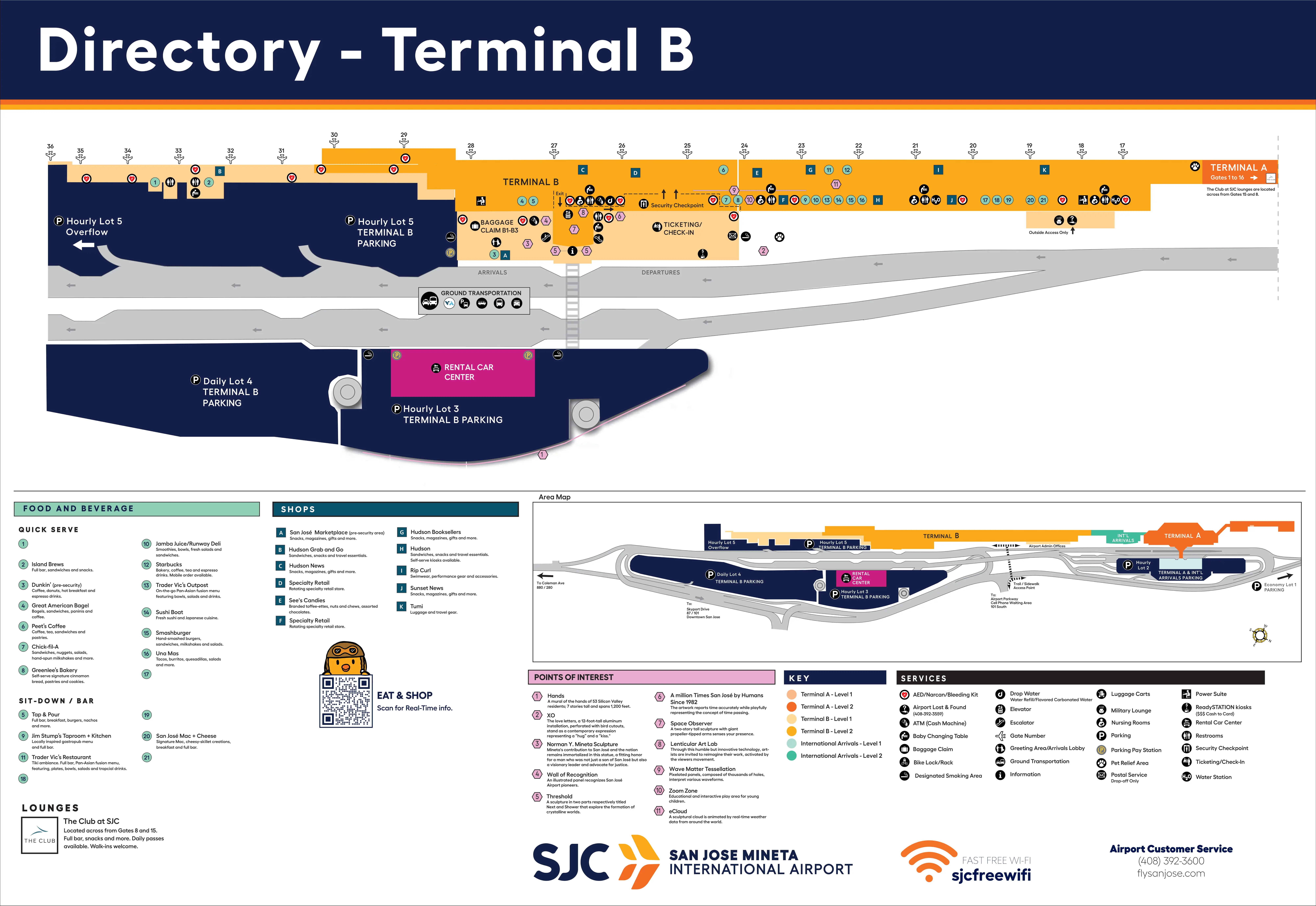
San José Mineta International Airport runs as a compact, linear two-terminal layout—Terminal A on the north end and Terminal B on the south end—set between Highway 101 and the runway complex. Landside areas operate separately, but the secure side functions as one continuous zone via the airside A↔B connector. Most congestion concentrates at Terminal B’s departures hall and single checkpoint, while the Mineta airport complex in San José keeps a faster, lower-stress alternative at Terminal A.
Map Table
| Terminal | Key Airlines | Primary Function | Transfer Mode |
|---|---|---|---|
| Terminal A | Delta, United, international carriers | faster security option, legacy capacity | airside connector near Gate 16 ↔ Gate 17 |
| Terminal B | Southwest, Alaska | main departures volume, longest gate walks | airside connector; landside curb/shuttle |
San José Mineta International Airport Map Strategy
- Treat Terminal B as a congestion zone during departure banks: if bag-drop lines are visible from Doors 6–8, switch tactics before you enter the hall.
- Use the Terminal A checkpoint workaround for carry-on only: clear security in Terminal A, then stay on Level 2 and walk the airside connector to emerge at Terminal B near Gate 17.
- Commit the A↔B connector direction rule: from Terminal A security, turn left/south toward Gates 15–16 and The Club SJC; turning right heads into a dead-end pier.
- Reduce ground-side friction by picking the correct drop-off: Economy Lot 1 riders who can skip bag check should exit at Terminal A first stop; rideshare users should cross to the Ground Transportation Island and walk south to the designated TNC stops instead of waiting at the curb.
2026 San Jose International Airport Map + Printable PDF
Terminal B still acts as the peak-hour pinch point because Southwest bag-drop and the vertical push to the Level 2 checkpoint compress into one lobby. The Terminal A checkpoint remains the reliable “pressure release,” including the earlier opening time, with a predictable 12–15 minute secure-side walk to Terminal B’s first gate cluster via the connector near Gates 16/17.
San Jose International Airport Terminal A Map 2025
San Jose International Airport Terminal B Map 2025
2026 San Jose International Airport Map Guide
What is the exact walking time (minutes) from the Terminal A security exit to the first Terminal B gate cluster (e.g., B20 area) using the airside connector route?
Walking takes 12–15 minutes from the Terminal A security exit to the first Terminal B gate cluster around Gate 20 using the airside connector.
The fastest path stays entirely on the secure departures level. From the Terminal A checkpoint exit, go left/south toward Gates 15–16 and The Club SJC, then continue past Gate 16 into the connector corridor. The connector is a single straight corridor with no moving walkways and no services until Terminal B. You exit into Terminal B near Gate 17, then continue 1–2 minutes down the main concourse to Gate 20.
Where is the fastest Terminal A→Terminal B airside path plotted step-by-step (decision points included) to avoid wrong turns?
The fastest Terminal A→Terminal B airside route is the Level 2 secure corridor that starts near Terminal A Gate 16 and exits into Terminal B near Gate 17.
- Exit Terminal A security on Level 2 and turn left/south toward Gates 12–16.
- Walk toward Gate 15 with The Club SJC as the key landmark.
- Continue past Gate 16 to the end of the Terminal A pier.
- Enter the airside connector corridor and stay on the same level.
- Exit the connector into Terminal B near Gate 17, then continue straight for Gates 18–36.
- Wrong-turn trap: turning right from security heads toward Gates 1–14 and dead-ends.
- No-return trap: taking any down escalator exits to baggage claim and forces full re-screening.
What is the exact curb-to-counter walking distance from Southwest (Terminal B) departures curb to the Southwest bag-check counters (feet/meters)?
Walking distance is about 80–120 feet (25–35 meters) from the Terminal B departures curb by Doors 6–8 to the Southwest bag-check counters.
The shortest line is typically curb → enter through Doors 6, 7, or 8 → counters directly ahead inside the check-in hall. The distance stays short because Southwest’s counter frontage faces those doors, but the usable path can be blocked when bag-drop queues spill back toward the entry vestibules and the interior window wall, forcing a slower weave to reach kiosks versus full-service counters.
Where is the bottleneck point in the Terminal B public check-in hall where bag-drop lines typically spill into (landmark + locator on the terminal plan)?
The bottleneck forms at the Southwest ticket counter zone facing Doors 6, 7, and 8 on the Terminal B departures level, where bag-drop lines back up into the entry vestibules.
The spillover typically pushes straight back from the Southwest counters toward those doors, then stretches along the interior glass/window wall and can pinch the main circulation lane leading to the central escalator bank up to Level 2 security. On a terminal plan, this is the south half of the Terminal B check-in hall directly in front of Doors 6–8 and immediately adjacent to the central escalator landing area.
What is the shortest indoor route from Economy Lot 1 shuttle drop-off to the Terminal B security entrance, including every major turn/landmark?
No fully indoor route exists from the Economy Lot 1 shuttle drop-off to Terminal B security because the shuttle drops at the Ground Transportation Island and requires an outdoor crosswalk segment to reach the terminal doors.
From the Terminal B shuttle stop on the Ground Transportation Island, walk across the marked crosswalk to the Terminal B curb, enter through Door 5 or Door 6, then turn left toward the central escalator bank in the middle of the check-in hall. Take the escalator or elevator up to Level 2 and make a U-turn at the top landing to face the main Terminal B security checkpoint entry lanes. Door 5 is slightly farther north and often bypasses the densest Southwest bag-drop crowd near Doors 6–8.
What is the walking time from Terminal B arrivals/baggage claim to the designated rideshare pickup zone, measured along the actual pedestrian path?
Walking takes 4–6 minutes from Terminal B baggage claim to the designated rideshare pickup zone along the signed pedestrian route.
Exit Terminal B baggage claim through Doors 6–8 on Level 1, cross the pickup roadway to the Ground Transportation Island, then walk south along the island past other stands to the rideshare slots. The key locator is the far south end of the island where rideshare stops cluster, so the time is driven more by the long island walk than by leaving the building. This segment is outdoors and exposed.
Where is the exact entrance for the Terminal A security checkpoint if arriving from the Terminal A parking garages, and what is the shortest path to it?
The Terminal A security checkpoint entrance is at the top of the central escalator bank on Level 2, reached from the Terminal A parking garages via the main Terminal A entry into the ticketing lobby.
From Hourly Lot 2 (Terminal A garage), follow the pedestrian bridge or crosswalk into Terminal A on Level 1, then walk to the middle of the ticketing hall and locate the escalators signed for “Departures / Security Checkpoint.” Ride up to Level 2 and continue forward to the checkpoint queue entry. The shortest path is the most direct garage-to-terminal crossing into the central lobby, staying aligned with the middle escalators rather than walking the length of the garage.
What is the walk time from the Terminal B security exit to the farthest Southwest gates (furthest-numbered gate area) using the main concourse route?
Walking takes 8–10 minutes from the Terminal B security exit area to the farthest Southwest gate zone around Gates 31–36 using the main concourse.
Terminal B’s checkpoint feeds you into the concourse near the low-20s gate area, so the route is a straight, full-length walk down the pier past the mid-concourse gates toward the south expansion. There are no moving walkways, and the perceived time increases if the concourse is crowded or if you stop at the main amenities cluster before continuing. Gates 31–36 sit at the very end of the Terminal B pier.
Where is the Priority Pass-accessible lounge area in Terminal A located relative to the airside connector, and what is the fastest route back to Terminal B gates after leaving it?
The Priority Pass lounge is The Club SJC in Terminal A, positioned airside near Gate 15 and one short walk north of the airside connector entrance by Gate 16.
The fastest return to Terminal B starts at The Club SJC’s exit near Gate 15: go down to the main concourse level if you’re not already there, then walk south past Gate 16 into the connector corridor. Stay on the secure departures level through the connector and exit into Terminal B near Gate 17, then continue straight down the Terminal B concourse to your assigned gate cluster. This route avoids any escalators that would drop you landside.
What is the fastest landside route from Terminal A baggage claim to Terminal B departures (outside/inside transitions explicitly mapped)?
Walking takes about 8–10 minutes and is usually the fastest landside route from Terminal A baggage claim to Terminal B departures because it avoids waiting for an inter-terminal shuttle.
Exit Terminal A baggage claim on Level 1, go outside to the curbside sidewalk, then turn south (toward Terminal B) and follow the continuous frontage sidewalk past the International Arrivals area toward Terminal B. Stay outside until you reach Terminal B departures doors, then enter the Terminal B check-in hall. The shuttle alternative adds variable wait time at the Ground Transportation Island plus a short ride, so it only wins when you have heavy luggage or mobility constraints.
Where are the two security checkpoints (Terminal A vs Terminal B) positioned on the overall layout, and what is the shortest gate-equivalent cross-terminal strategy to exploit the “A is faster” workaround?
Terminal A security is at the north end of the airport on the departures level, and Terminal B security is at the south end on the departures level, with the secure-side connector linking the gate areas near Terminal A Gate 16 and Terminal B Gate 17.
The shortest “A is faster” strategy is to enter Terminal A, clear security there, then immediately walk south past Gate 15/The Club SJC to Gate 16 and take the airside connector to emerge in Terminal B near Gate 17. This works best for carry-on only because checking bags still requires Terminal B’s Southwest counter area. A practical break-even trigger is a large visible Terminal B queue that reaches the central escalators or doors while Terminal A remains flowing.
What is the exact path length from Terminal B baggage claim to the point where economy-lot shuttle queues form (so a traveler can decide walk vs wait)?
Path length is about 150–200 feet (45–60 meters) from Terminal B baggage claim to the Ground Transportation Island area where Economy Lot 1 shuttle queues form.
Exit Terminal B baggage claim through Doors 6–8 on Level 1, cross the first pickup roadway at the marked crosswalk, and arrive on the Ground Transportation Island at the shuttle stop area (commonly labeled for shuttle buses). The walk is short enough that the decision is almost entirely about shuttle wait time versus shuttle ride time, not about the effort to reach the queue.