San Francisco International Airport Terminal 3 Map (Most Up-To-Date)
San Francisco International Airport Terminal 3 is a long, east–west domestic complex split into an E-pier (east) and an F-pier (north), with a central rotunda/core that feeds security exits and the main airside crossroads. In the current construction phase, the “front door” behavior has shifted: Terminal 3 functions as a partial shell while within San Francisco’s main airport complex many United D/E-gate passengers are routed through Terminal 2 for check-in and screening, then back airside via connectors.
Map Table
| Zone | Connection | Walk Time |
|---|---|---|
| Terminal 3 East lobby (Doors 1–5) | F1/F3 checkpoints, F Pier | 0–5 min |
| Terminal 3 lobby (Door 3/4 area) | Terminal 2 Checkpoint D | 5–7 min |
| AirTrain “Terminals 2 & 3” station | Terminal 3 security via “E Walkway” detour | 4–6 min |
| Airside near D18 | T2 ↔ T3 secure connector to E1/E2 | 8–11 min |
| F rotunda/core | Interim F ↔ G walkway to Int’l G | 6–8 min |
San Francisco International Airport Terminal 3 Map Strategy
- Construction reroutes are the default condition; treat Terminal 3 as “east-only access” and assume your usual security and curb entry path may be blocked the day you travel.
- Terminal 2 Checkpoint D is the reliable fallback when Terminal 3 lines spike; commit early landside, then return airside through the D18 secure connector toward E1/E2.
- AirTrain planning starts at the “Terminals 2 & 3” station; the winning move is the bridge-level U-turn into the “E Walkway” path, not a search for a Terminal 3 station entrance.
- Use fixed decision nodes, not vibes: the post-security hub at F1 and the E1/E2 pier entrance are the two landmarks that prevent wrong-terminal sprints during temporary closures around E/F/G.
2026 San Francisco International Airport Terminal 3 Map + Printable PDF
In 2026, Terminal 3 remains in an active modernization and reroute period: the west side footprint is functionally removed, the Terminal 3 AirTrain access is closed, and curbside capacity is compressed by the Doors 6–13 blockade. United operations are split, with many D/E-gate check-in flows pushed into Terminal 2, making the connectors and alternate security plans part of the “normal” map.
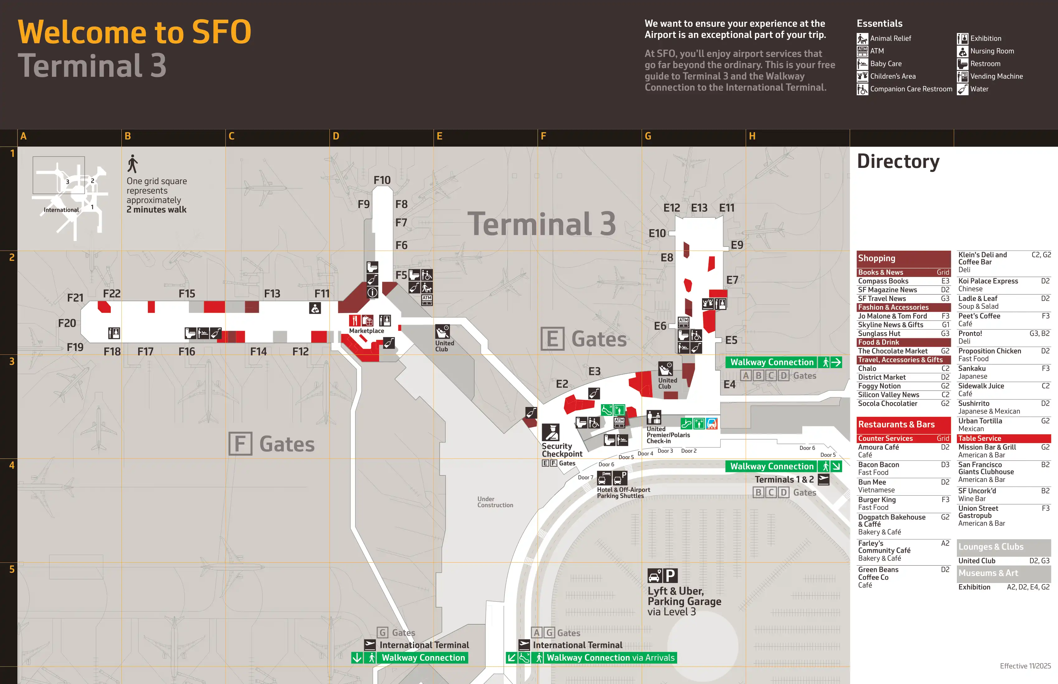
2026 San Francisco International Airport Terminal 3 Map Guide
What is the exact walking distance from Terminal 3 check-in/lobby to the Terminal 2 (D gates) security checkpoint entrance (the “escape route” when T3 lines blow up)?
The landside walk is about 1,200 feet (365 meters) from the active Terminal 3 lobby area near Doors 3–4 to the Terminal 2 Checkpoint D entrance, typically 5–7 minutes at a normal pace.
The simplest mapped route starts at Terminal 3 Departures near Door 3 (United’s active east-side counters), exits to the curbside sidewalk, and turns west (left if you’re facing the roadway). Keep walking past the closed Doors 6–13 barrier line until the pedestrian flow naturally funnels toward Terminal 2; enter Terminal 2 via its east-side doors (commonly Doors 1–2), then walk to the centrally placed Checkpoint D by the United temporary counters. The key decision node is around Terminal 3 Door 5—commit to the exterior sidewalk there to avoid dead-end construction walls inside.
What is the exact walking distance from the Terminal 2 security exit to the start of Terminal 3 (E/F) gates via the airside connector?
Walking is about 1,850 feet (565 meters) from the Terminal 2 Checkpoint D exit to the start of Terminal 3 E-gates at the E1/E2 area via the post-security connector, usually 8–11 minutes.
The route begins in Terminal 2’s post-security recompose area: make the hard left turn toward the D concourse instead of drifting straight toward the main retail/food pull. Continue down the D-gates corridor to the far end at Gate D18, where the signed “Terminal 3 / E & F Gates” connector begins. The connector itself is a straight, enclosed corridor (with moving walkways when operating) and ends by the Terminal 3 E-pier entrance around Gates E1/E2, which is the landmark that tells you you’ve fully “re-entered” Terminal 3 airside.
What is the shortest mapped walking route from the AirTrain (Terminal 2 station) to Terminal 3 security during periods when the Terminal 3 AirTrain bridge/connection is closed?
The shortest detour is about 800 feet (245 meters) from the AirTrain “Terminals 2 & 3” station to Terminal 3 security, typically 4–6 minutes, and it requires a bridge-level U-turn rather than entering Terminal 2 first.
After exiting the AirTrain, go down to the pedestrian bridge level (not the platform level) using the escalator/elevator. On that bridge level, follow the “Terminal 3” / “E Walkway” wayfinding that backtracks east through the garage connector infrastructure, crossing the bridge that feeds into Terminal 3 east of the construction wall. Once you enter Terminal 3, continue inside to the nearest open checkpoint (commonly F1 when the west/mezzanine checkpoint is closed). The main failure mode is staying on the wrong level and hunting for a Terminal 3 station entrance that no longer exists.
Which exact pedestrian entry route reaches F-gates security fastest when the F pier bridge/tunnel is closed (construction routing scenario)?
Using Domestic Garage Core E is the fastest pedestrian entry when the Core F bridge/walkway is closed, because Core E still delivers you into Terminal 3 without a garage backtrack.
Park in the Domestic Garage as close to Core E as possible, then take the Core E elevators up to the pedestrian bridge level and cross directly into Terminal 3 near the central E/rotunda side of the departures-level interior. After you enter the terminal, follow overhead “F Gates” signs across the lobby to the active F-side screening area, then commit into Checkpoint F1 (primary) or F3 (overflow hours) at the F-pier entrance. The key landmark check is simple: if you arrive at Core F and see a closed bridge, turn back inside the garage to Core E immediately instead of trying to force a landside detour.
What is the exact airside walking distance from Terminal 3 F-gates to International Terminal G-gates using the current temporary F↔G connection?
Walking is about 1,500 feet (450 meters) total from the Terminal 3 F rotunda/core to the International Terminal G boarding area, with roughly 1,000 feet (305 meters) of that inside the interim F↔G connector itself, typically 6–8 minutes.
The signed entry point is at the Terminal 3 rotunda by the F-pier side, where overhead signs direct you to “International Terminal / G Gates.” From the rotunda, enter the glass-walled interim corridor (the long, linear “tube” with distance markers), stay on the single continuous path, and exit directly into the International Terminal G secure-side concourse. The dealbreaker is commitment: there are no mid-corridor exits or services, so once you enter, you’re walking the full length to G.
Where exactly does the temporary F↔G walkway connect into the Terminal 3 rotunda/core (identify the precise tie-in point using fixed landmarks like former gate areas)?
The temporary F↔G walkway ties into Terminal 3 at the rotunda/core on the F-pier side near the United Club (F Gates) and the Gate F11/F12 area.
From inside Terminal 3, use the rotunda food court as your primary anchor point; the connector entry is on the same rotunda edge that opens toward the F gates portal rather than the E-pier corridor. If you can see the United Club (F Gates) entrance zone and you’re in the Gate F11/F12 vicinity, you’re at the correct “plug-in” node where the interim structure leaves the building footprint and swings out toward the airfield to bridge the construction gap. Overhead signage for “International Terminal G” should be clustered at this exact rotunda-side throat.
After clearing security, where is the exact decision point (physical intersection) where a traveler must choose the correct direction for E gates vs F gates vs the G connector to avoid a wrong-terminal sprint?
The critical decision point is the post-security exit hub immediately outside Terminal 3 Checkpoint F1, where the flow opens into the Terminal 3 rotunda/core and splits left toward E and right/forward toward F and the G connector.
From the F1 recompose area, use the rotunda opening as the “intersection.” Turning left takes you onto the E-side corridor toward the E-pier entrance (E1/E2 area) and the signed path toward the Terminal 2/D connector. Turning right or continuing into the rotunda feeds the F gates portal and the interim walkway to International G. The most common failure pattern is following the crowd pull toward the rotunda food options; the fix is to pause at the F1 exit line, find “E Gates” or “International G,” then commit before you start walking.
Where is the current CLEAR entry point for travelers who would normally use it at Terminal 3, given reports it has shifted toward Terminal 2 during construction?
The most reliable CLEAR entry point for United D/E-gate travelers is at Terminal 2 Checkpoint D, because Terminal 3’s CLEAR availability at F1 can be intermittently constrained during the construction phase.
In Terminal 2, CLEAR access is positioned at the Checkpoint D screening area on the departures level, with the lane integrated alongside the TSA flows near the main counter hall; a practical fixed anchor is that the checkpoint zone sits across from the Delta counter area in Terminal 2’s lobby. Terminal 3’s F1 checkpoint may still show CLEAR signage, but the consistent “don’t gamble” play during this reroute era is to start in Terminal 2, clear at D, then use the airside connector by Gate D18 to return to Terminal 3 at E1/E2.
What is the exact walking distance from the Terminal 2 (D) checkpoint exit to a representative mid-pier Terminal 3 E-gate (e.g., the start of E gates), using the signed airside route?
Walking is about 2,250 feet (685 meters) from the Terminal 2 Checkpoint D exit to a representative mid-pier Terminal 3 E-gate such as E6, typically 11–14 minutes.
The signed airside route starts at the Terminal 2 recompose area, then heads down the D concourse to the far end near Gate D18, where the “Terminal 3 / E Gates” connector begins. After crossing the connector, you emerge at Terminal 3 by the E1/E2 pier entrance; continue into the E-pier past the early gates to reach E6, which adds the final “mid-pier” segment beyond the connector exit. The navigation anchor that confirms you’re on-track is the E1/E2 area signage—if you don’t see it after the connector, you’ve missed the correct corridor.
What is the exact walking distance from the most common Terminal 3 curbside drop-off zone to the best alternate security entrance (Terminal 2/D) during T3 curb/entry disruptions?
Walking is about 1,500 feet (450 meters) from a common Terminal 3 Arrivals-level drop-off (around Doors 10–12) to Terminal 2 Checkpoint D, typically 7–9 minutes.
A reliable mapped sequence starts at Terminal 3 Arrivals near Door 10: go inside and take the nearest elevator/escalator bank up to the Departures level, then head west toward Terminal 2. Exit at an open departures door near Door 5 to avoid the internal dead-ends, then follow the exterior sidewalk past the closed Doors 6–13 construction barrier line until you reach Terminal 2’s entry doors (often the east-side doors). Once inside Terminal 2, continue to the centrally located Checkpoint D adjacent to the temporary United check-in area. The key decision is to move up to Departures before the westward walk; staying on Arrivals adds noise, conflict points, and slower pedestrian flow.
Where is the exact location of the airside connector entrance signage that directs passengers from Terminal 3 toward Terminal 2/D (the “don’t get trapped in T3 line” route)?
The connector signage is positioned at the Terminal 3 E-pier entrance zone around Gates E1/E2, where overhead wayfinding points toward “Terminal 2” and “D Gates” for the secure connector.
From Terminal 3’s central post-security core, move toward the E-gates side (not the rotunda/F side). As you reach the E1/E2 throat—the point where the E-pier begins—look for the overhead signs directing “Terminal 2 / D Gates / Connector,” which guide you along the window-line corridor that leads into the enclosed connector. The fixed landmark that confirms you’re at the right spot is the E1/E2 gate cluster itself; if you’re already deep in the E-pier, you’ve gone past the best “turn-off” point and will have to backtrack to the pier entrance.
What is the exact mapped walking distance from the (temporary) Centurion access path back to Terminal 3 E-gates, accounting for the temporary walkways now required?
Walking is about 2,100 feet (640 meters) from the temporary Centurion Lounge location in Terminal 2 near Gate D12 back to the active Terminal 3 E-gates area (around E5/E6), typically 10–13 minutes.
The signed path runs from Gate D12 down the D concourse toward the far end by Gate D18, then through the T2↔T3 secure connector corridor, exiting into Terminal 3 at the E1/E2 pier entrance. From E1/E2, continue into the E-pier to the central E-gate block (E5/E6 range) for a representative endpoint. The practical dealbreaker is time: a round trip between Terminal 3 and the temporary Centurion setup adds roughly 20–25 minutes of pure walking before you’ve spent a second in the lounge, so it’s a high-risk diversion with tight boarding windows.
Archive San Francisco International Airport Terminal 3 Maps
Below are all historical map versions for San Francisco International Airport. Each year includes the official map available for that period, presented as both WebP and PDF.
2023 San Francisco International Airport Map