Rio Galeão Tom Jobim International Airport Map (Most Up-To-Date)
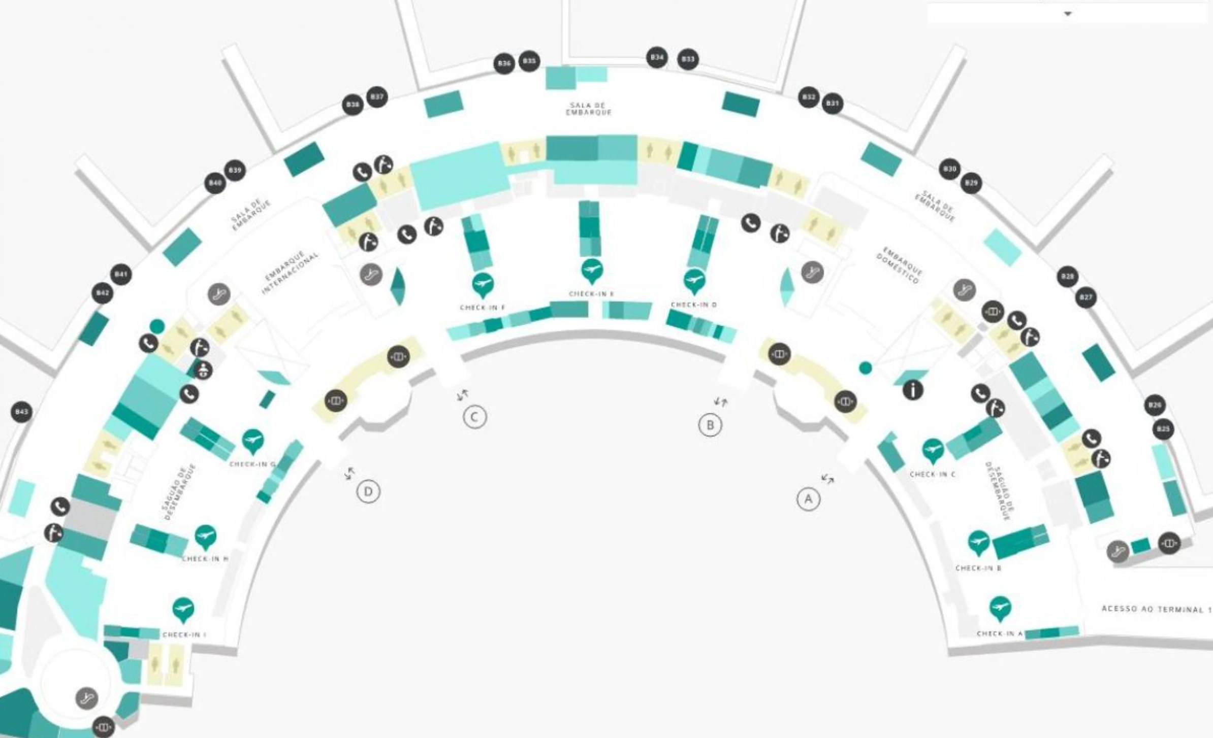
Rio Galeão – Tom Jobim International Airport (GIG) is a two-terminal campus where passenger operations concentrate in the long, curved Terminal 2, while Terminal 1 is largely dormant and functions as a common misdrop “trap.” Across the Galeão airport grounds, the layout is defined by an arrivals-level curb running the full arc of T2, door-labeled decision points (A–D), and separated ground-transport nodes (Uber Lounge vs BRT median station) that punish wrong exits with long backtracking.
Map Table
| Terminal | Key Airlines | Primary Function | Transfer Mode |
|---|---|---|---|
| Terminal 2 | LATAM, GOL, Azul, major long-haul carriers | Domestic + International processing | Walk landside, curbside lanes |
| Terminal 1 | Limited / intermittent use | Dormant / overflow | Connector walkway, travelators |
| Terminal 2 Arrivals Level | Rideshare, taxis, buses | Ground transport interface | Door-labeled exits, curb zones |
| Terminal 2 Departures Level | All departing passengers | Check-in, security, passport control | Central escalators/elevators |
Rio Galeão – Tom Jobim International Airport (GIG) Map Strategy
- Make door labels your control surface: committing to the wrong Arrivals exit is what triggers long corrective walks, curbside confusion, and solicitor pressure.
- Treat rideshare as a dedicated pickup system, not “any curb”: the sanctioned Uber Lounge vector is a specific Door→walkway→sector routine, and improvising at the curb increases scam exposure.
- Budget for the airport’s geometry penalty: the curved Terminal 2 layout hides destinations and inflates end-to-end walks, so confirm your target zone (international vs domestic side) before moving.
- Assume queues begin at fixed landmarks, not where stanchions start: check-in lines spill into the main hall near the check-in islands, and passport-control queues can form immediately after security output.
2026 Rio Galeão Tom Jobim International Airport Map + Printable PDF
Operationally at 2026, the printable map that matters is the one that clarifies what’s actually open and where flows truly start: Terminal 2 as the default processing terminal, Terminal 1 as a navigation trap, and door-labeled decision nodes on Arrivals that determine whether you reach the Uber Lounge, official taxis, or the BRT/bus corridors without backtracking.
Rio Galeão Tom Jobim International Airport Terminal 1 Level 0 Map 2026
Rio Galeão Tom Jobim International Airport Terminal 1 Level 1 Map 2026
Rio Galeão Tom Jobim International Airport Terminal 1 Level 2 Map 2026
Rio Galeão Tom Jobim International Airport Terminal 2 Level 0 Map 2026
Rio Galeão Tom Jobim International Airport Terminal 2 Level 1 Map 2026
Rio Galeão Tom Jobim International Airport Terminal 2 Level 2 Map 2026
2026 Rio Galeão – Tom Jobim International Airport Map Guide
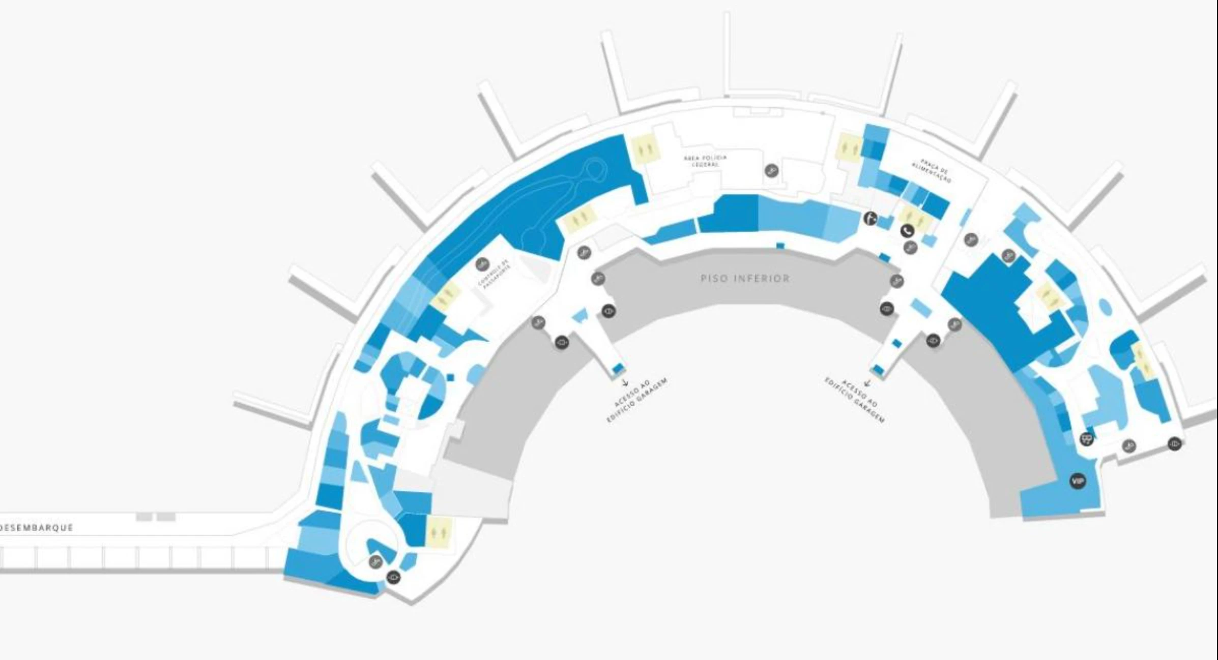
What is the exact walking distance (meters) from international customs exit to the designated Uber pickup point at GIG?
The walking distance is 350–400 meters from the international customs exit (Doors C/D axis) to the Uber Lounge pickup point reached from Door A. That total includes a long internal traverse across the Arrivals hall plus the covered “catwalk” that leads off the curbside area into the rideshare lounge sectors.
| Segment | From → To | Meters |
|---|---|---|
| Arrivals hall traverse | Customs discharge at Doors C/D → Door A (inside, parallel to the curb) | ~250–300 m |
| Rideshare access walkway | Door A → covered catwalk entrance by the taxi queue | included in next |
| Catwalk to lounge | Catwalk entrance → Uber Lounge sector meeting area | ~100 m |
| Total | Doors C/D axis → Uber Lounge | ~350–400 m |
Which exact door/exit label from the arrivals hall is the shortest path to the designated Uber pickup point?
Door A is the correct arrivals exit label for the designated Uber pickup, because the Uber Lounge access starts from Door A and then continues along the covered catwalk to the lounge sectors. Exiting at Doors C or D puts you at the international end where solicitors cluster and forces either a curbside gamble or a longer, higher-friction correction.
Use this sequence: stay inside after customs at the Doors C/D discharge, turn right into the Arrivals hall, walk past the central atrium toward the domestic end, then exit at Door A and follow the covered catwalk away from the facade to the Uber Lounge (color-coded sectors).
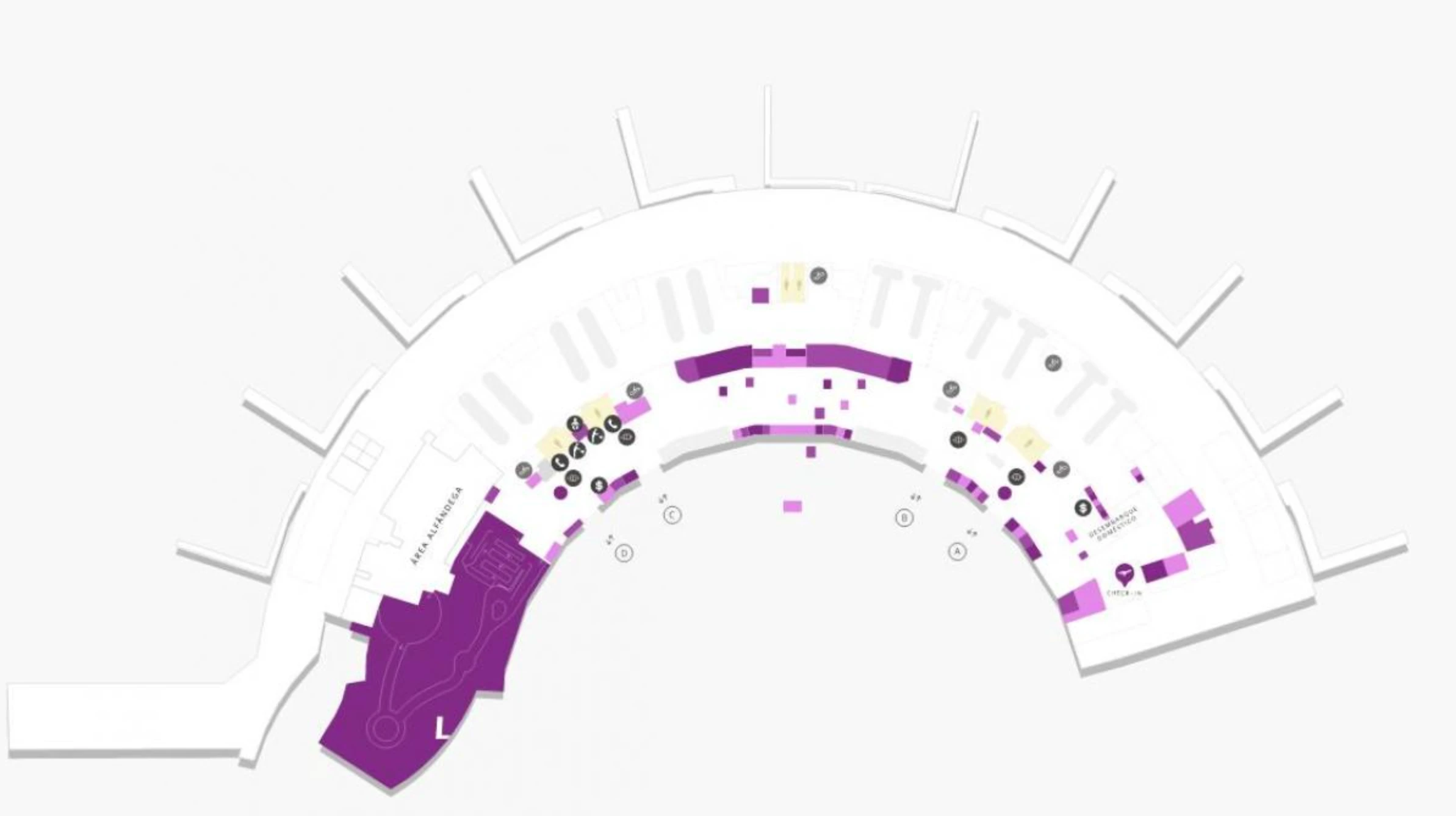
Where is the BRT stop “outside Exit C” located relative to the arrivals doors (which curb zone/side), in a way that can be confirmed on a terminal map?
The BRT TransCarioca station is on the roadway median at the international end of Terminal 2, directly opposite Arrivals Door D on the west side of the facade. That means the map-confirmable reference is Door D, not the domestic-side doors, and the station sits as an island platform in the center of the Arrivals roadway.
Exit through Door D, face the curb, and look straight ahead to the median structure signed for TransCarioca; you reach it by crossing the first curb lane to the station island. Exiting at Door C and walking toward Door A is the wrong vector for BRT and adds avoidable terminal-length distance.
What is the exact walking distance (meters) from Arrivals to Exit C at Terminal 2?
The walking distance is 0–30 meters because Exit C is effectively the international arrivals discharge point on Terminal 2’s Arrivals level. After immigration/customs, you enter the public “greeter” buffer and you’re already on the Door C/D node.
Practically, the only distance is the depth of the post-customs corridor to the sliding glass doors labeled C (and adjacent D). If you can see the curb and the meet-and-greet area, you’re at Exit C; any extra steps are just moving within the same arrivals hall frontage.
What is the exact end-to-end walking distance (meters) between the domestic side near Gate A and the international side near Gate C inside Terminal 2?
The end-to-end walking distance is approximately 750–850 meters between the domestic-side end near Gate A and the international-side end near Gate C inside Terminal 2. That span reflects the full-length “elliptical horizon” of the curved concourse, where you can’t visually confirm the far end and time penalties stack fast if you drift the wrong way.
Plan the walk as a long single spine: the main concourse curves continuously past the central commercial/atrium zone, then runs out to the opposite wing. When you’re near the Gate A domestic extremity, the closest “triangulation” anchors are the domestic-side services and shorter domestic queues; when you’re near the Gate C international extremity, anchors shift to the international boarding flow and longer outbound corridors.
What is the shortest mapped route (single corridor path) from the Gate C departures zone to the Gate A departures zone without leaving the secure area?
You usually cannot complete this walk without leaving the secure area because international and domestic flows in Terminal 2 are typically segregated by glass partitions and controlled doors. That legal/operational separation is the dealbreaker: even though the building has a continuous curved spine, the “secure-side” path is commonly blocked outside specific same-status transfer scenarios.
Physically, the shortest corridor would be the main Level 2 airside concourse running along the terminal’s curved spine from the Gate C end toward the Gate A end. Operationally, most travelers who try this hit a barrier and must exit to landside, traverse toward the correct check-in zone, and re-clear security for the correct side.
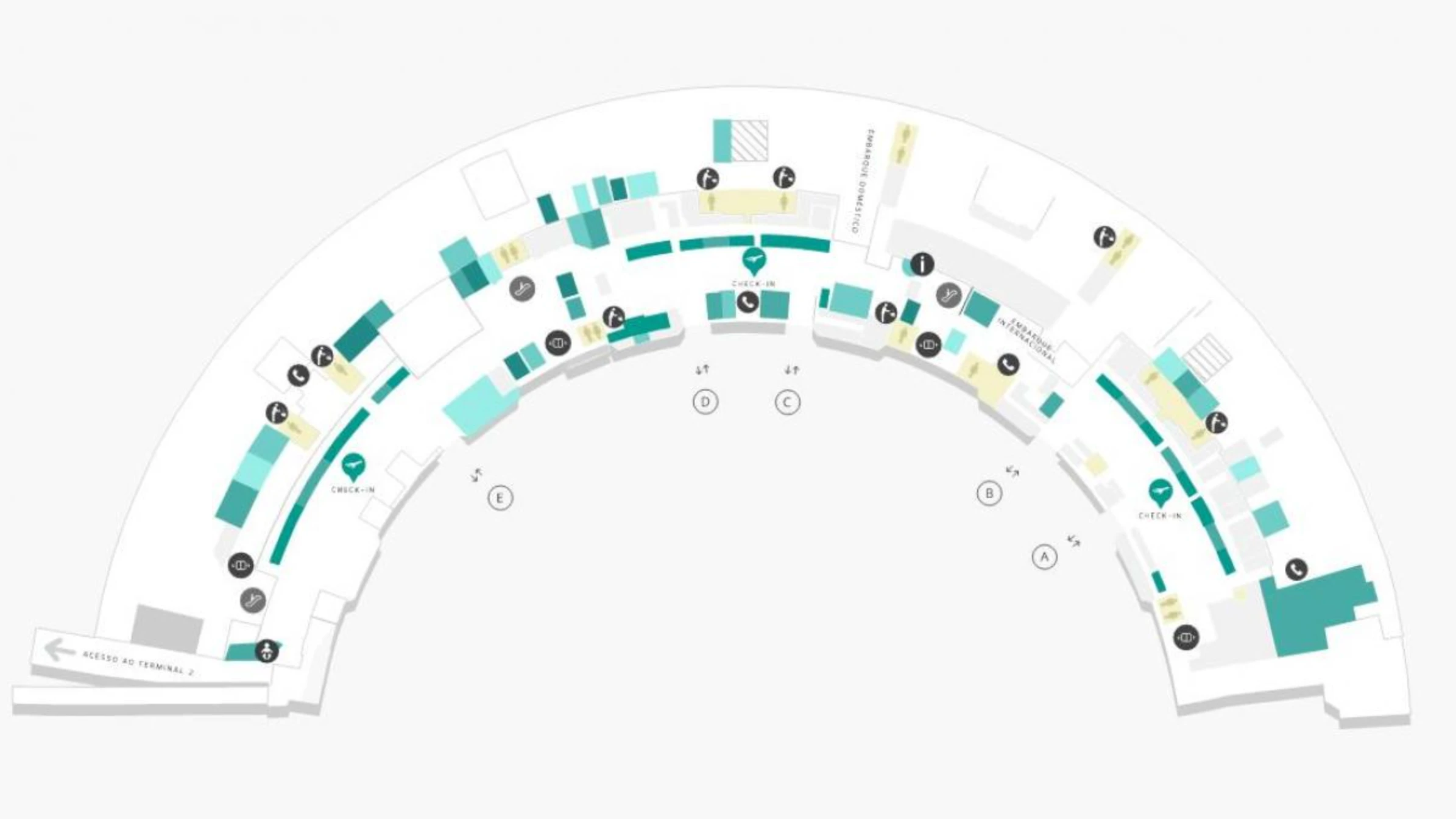
Where is the actual physical start point of the main check-in queue (the “real line,” not the stanchions) for major international airlines in Terminal 2?
The physical start point is usually in the main Departures hall circulation corridor beside the west/central check-in islands, near the central atrium area where the queue overflow spills out beyond the stanchions. That “real line” forms at the open walkway edge of the island—where passengers first encounter the island’s entrance throat—rather than at the counters.
Look for the end-of-line cluster near the wide corridor that runs parallel to the islands, commonly adjacent to the flight information screens and the island “prow” that faces the hall. If the corridor is clogged between Doors B and C, the line has already escaped the formal lanes and the true end will be in the pedestrian flow zone, not inside the roped maze.
Which exact landmark (counter island / entrance throat) is where passengers report the queue bottleneck forming for check-in at Terminal 2?
The bottleneck forms at the entrance throat of the west/central check-in islands—commonly described as Islands B and C—where passengers entering from the curbside doors collide and the queue “snakes” out into the main hall. That choke point is the narrow approach face of the island (the side you hit first when you turn 90° off the curb-facing doors), not the rear of the counter bank.
This is easiest to confirm on a terminal map by triangulating between the central atrium circulation band and the international check-in zone on the west side: the queue jam sits where the island’s front corner projects into the main walkway between the Door B and Door C approach corridors. When it’s busy, the overflow blocks straight-through walking along the hall parallel to the islands.
Where is the exact location of the international departures security checkpoint entrance in Terminal 2 (so a traveler can confirm the correct approach corridor on a map)?
The international departures security checkpoint entrance is on Level 2 (Departures) in the west wing of Terminal 2, positioned past the international check-in islands toward the far left/international end. On a map, the confirmable approach is “check-in islands (international zone) → continue west/left along the departures hall → marked international boarding/security portal.”
The most reliable triangulation is to treat it as the terminal-extremity portal: after bag drop in the west-side international check-in area, keep moving left rather than returning toward the central atrium. The entrance presents as a wide access point aligned with the international flow, distinct from smaller domestic-side access points and designed to funnel directly into screening lanes.
Where does the departure passport-control queue physically begin (first fixed landmark) after security in Terminal 2?
The passport-control queue begins at the security exit area, effectively anchored to the x-ray/scan output rollers immediately after screening. The lack of buffer space is the defining feature: the stanchions for Polícia Federal commonly start within a few meters of where passengers collect trays.
Use the landmark chain to confirm you’re in the right place: security lanes → metal detector exit → tray/roller reclaim zone → the first fixed stanchion posts for the Federal Police line. If you stop to repack at the belt, you’re standing inside the funnel that feeds the passport-control queue.
What is the exact vertical path (specific escalator/elevator bank) from Arrivals (ground floor) to Departures (2nd floor) that minimizes backtracking for a domestic re-check?
The central escalator/elevator bank on the Doors B/C axis is the vertical path that minimizes backtracking because it deposits you at the pivot point of the Departures hall, where you can choose domestic (right/east) or international (left/west) without committing to a long end-of-terminal walk. This is the most “equidistant” vertical move in Terminal 2.
From the international arrivals discharge at Doors C/D, stay inside the Arrivals hall and move toward the central atrium area, then take the central escalator up to Level 2. Avoid using far-end vertical cores near Door A (too domestic-leaning) or the extreme west end (too international-leaning) unless you’re already certain which side your re-check requires.