Reno Tahoe International Airport Map (Most Up-To-Date)
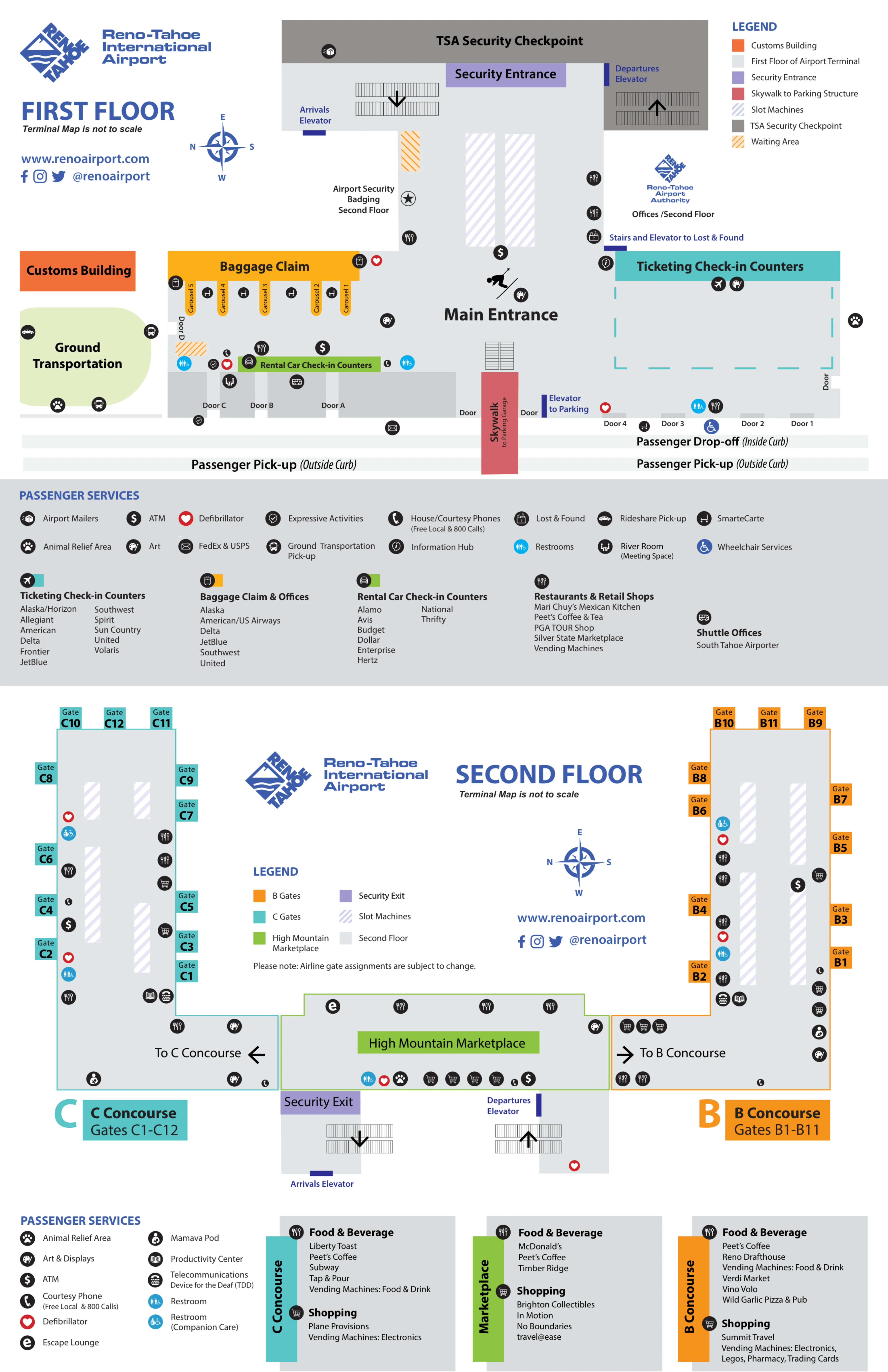
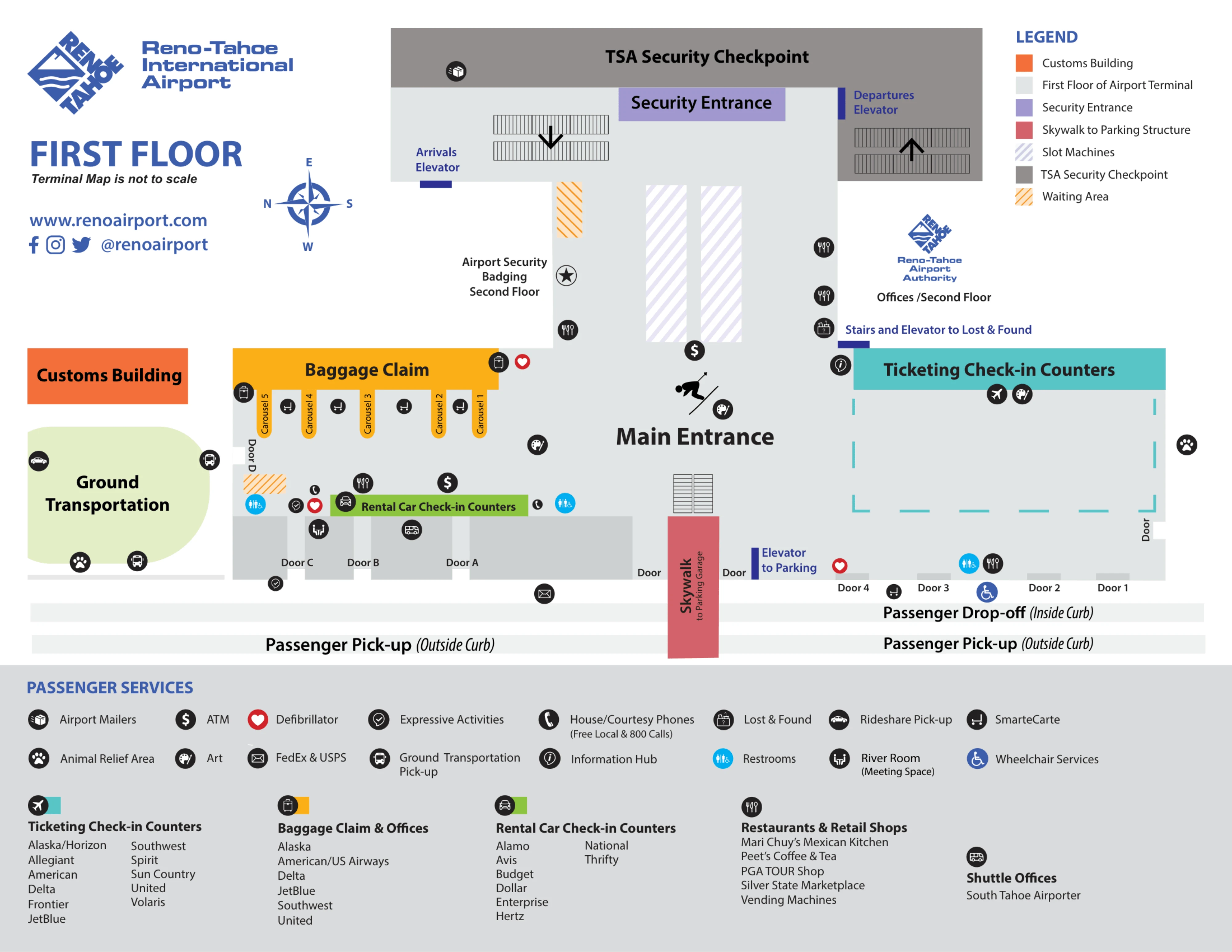
Reno–Tahoe International Airport (RNO) runs as a single, bi-level terminal where almost everything funnels through one central hall within Reno’s main airport grounds. Ticketing/check-in and baggage claim sit on the ground floor with one main Security checkpoint in between, while gates and concessions live upstairs. The building reads “small,” but the layout behaves like a funnel: one checkpoint for departures and one dominant arrivals exit (Door D) for most ground transportation.
Map Table
| Terminal | Key Airlines | Primary Function | Transfer Mode |
|---|---|---|---|
| Single terminal | Southwest, United, Delta | Ticketing hall, central Security, baggage claim | Walkways, curb loop |
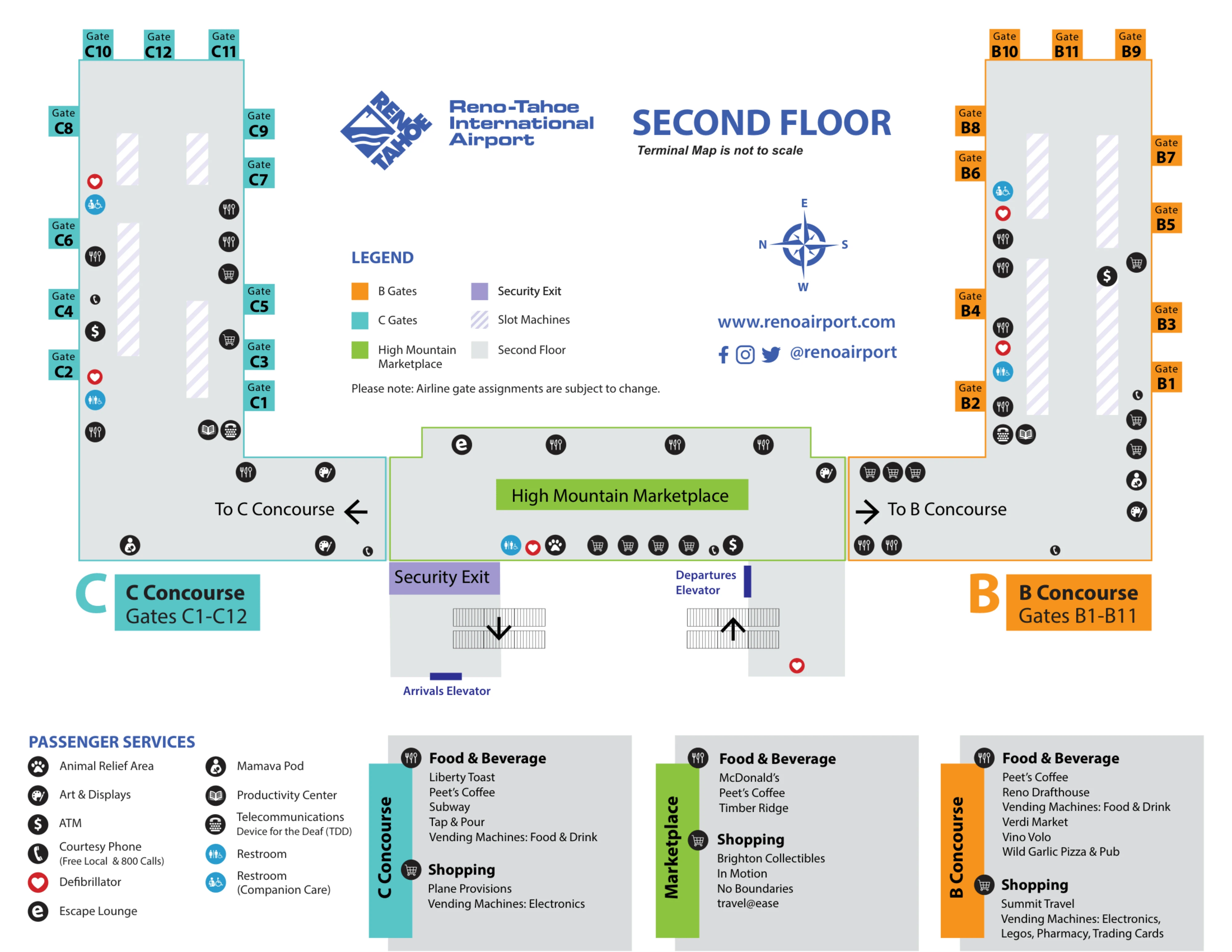
| Concourse B | Southwest | Gates, concessions access | Escalators, elevators |
| Concourse C | United, Delta, American | Gates, concessions access | Escalators, elevators |
| Door D complex | All arrivals ground transport | Taxi curb, rideshare lot access, shuttle slots | Crosswalk to rideshare shelter, curb lanes |
Reno–Tahoe International Airport Map Strategy
- Start every departure plan by locating the central Security checkpoint entrance first, then backtrack to check-in; when the line overflows, stand on the Tahoe-blue/black “river” terrazzo path, not along the beige edge tiles where people are just passing through.
- Treat ~04:00 as a hard decision node: the building may be open, but airside access is sealed until the checkpoint opens, so arriving “too early” means a landside wait where the first real queue forms directly at the Security shutter.
- For arrivals, commit to Door D before you exit baggage claim; taxis load immediately at the Door D curb, while Uber/Lyft require crossing the lane to the rideshare shelter in the North Lot—no curb pickup, no exceptions, no “wait here and hope.”
- Choose parking and shuttles by exact walking and loading points: long-term garage is roughly 150–250 m (2–5 minutes), long-term surface lot roughly 250–400 m (3–5 minutes), and overflow “Purple Lot” roughly 800–1000 m (10–15 minutes) where the shuttle becomes the time-critical variable.
2026 Reno Tahoe International Airport Map + Printable PDF
Current maps for 2026 should be read with two “reality checks” in mind: the airport’s single Security checkpoint can spill out of its stanchions into the ticketing hall, and Door D controls most arrivals ground-transport decisions. The post-2024 ticketing-hall flex space and the “Truckee River” terrazzo path are the practical cues for where lines and walking routes actually form when the hall gets busy.
Reno Tahoe International Airport Level 1 Map 2026
Reno Tahoe International Airport Level 2 Map 2026
2026 Reno Tahoe International Airport Map Guide
What is the exact physical start point of the standard Security queue, and which named landmarks does it reach when it overflows into the main hall?
The standard Security queue starts directly at the central Security Checkpoint entrance (the shuttered/stanchioned entry) on the first floor between the ticketing counters and the baggage-claim hall. When it outgrows the stanchions, the line runs backward into the ticketing-hall flex space created by the 2024 expansion, following the Tahoe-blue and black “Truckee River” terrazzo path. In heavy spillback, the tail reaches the Ski Statue near the main terminal entrance, which signals you’re at the far end of the overflow corridor rather than near the checkpoint mouth.
Which specific door(s) are the correct rideshare pickup exits from baggage claim (e.g., “north doors”), and what curb zone do they feed onto?
Door D is the correct rideshare pickup exit from the baggage-claim hall, positioned at the far north end past the carousels. Door D opens onto the Ground Transportation Loop curb, but Uber/Lyft do not load at the immediate curb segment outside the doors. The usable pickup zone is the designated rideshare shelter in the North Lot, reached by taking the marked crosswalk from Door D across the active taxi/curb lane into the lot-side staging area. Exiting Door A, B, or C forces a longer curbside walk north to reach the Door D crossing point.
What is the walking distance (and typical walk time) from the long-term parking area to the terminal entrance used for check-in/security?
Walking from RNO long-term parking to the ticketing/security entrance typically takes 2–5 minutes from the Long-Term Garage and 3–5 minutes from the Long-Term Surface Lot. The Long-Term Garage route runs roughly 150–250 meters to the terminal via the crosswalks and/or the skybridge opposite the ticketing hall. The Long-Term Surface Lot route is roughly 250–400 meters depending on where you park, with more exposure and extra lane crossings compared with the garage. If you’re sent to the overflow Purple Lot, the walk jumps to roughly 800–1000 meters (10–15 minutes), making the shuttle the practical default.
When early-morning access is restricted, which exact entrance/door is the first point where passengers can physically form the Security line (the “locked door” decision node)?
The first place passengers can physically form the Security line is the Security Checkpoint shutter itself on the first floor, not an exterior entrance door. The terminal’s main ticketing-hall sliding doors allow you into the building, but the “locked door” decision node is the closed checkpoint frontage where people begin queuing in front of the shutter before the lanes open around ~04:00. The practical landmark is the central checkpoint mouth between ticketing and baggage claim, where the line starts compressing as soon as the shutter lifts.
Where is the precise pickup point for offsite hotel/casino shuttles returning to the airport, and which side/curb level do they load on?
Offsite hotel and casino shuttles pick up outside baggage claim at Door D on the Ground Transportation Loop. Loading happens in the designated shuttle/bus slots along the loop curb at the north end of the baggage-claim hall rather than at the departures (ticketing) curb. The key landmark is Door D itself: exit at Door D, then look for the signed shuttle loading positions grouped on the loop curb in that same Door D ground-transportation zone, not in the taxi queue lane and not across in the rideshare lot.
For the most-used “park at a casino + shuttle” workaround, what is the exact shuttle stop location on-property (pinpointed to a lot section / entrance) that travelers should walk to?
The shuttle stop is the casino’s main hotel entrance loading zone, not a random point in the parking lot. For Grand Sierra Resort, the pickup is at the Front Desk / Port-Cochere area at the main entrance. For Peppermill, the pickup is at the Valet Area outside the hotel lobby. For Atlantis, the pickup is at the main entrance/valet area. The consistent landmark rule is to park, then walk to the front drive where valet and guest drop-off happen; the shuttle does not do lot-side pickups.
From baggage claim, what is the shortest walking route (doors + turns) to the rideshare staging/waiting area, and where do people commonly go wrong?
Walking to rideshare takes the Door D route: from your baggage carousel, walk north along the baggage-claim hall, exit through Door D, then continue straight across the marked crosswalk into the North Lot to the rideshare shelter. The common mistake is stopping immediately outside Door D at the taxi curb and waiting there for Uber/Lyft. That curb segment is a dead zone for rideshare loading, so drivers circle the lot-side shelter area while passengers stand at the wrong curb and get cancellations.
If the Security line spills into the main hall, what is the exact path boundary of the overflow (which corridor edges/fixtures define “in line” vs “not in line”)?
The overflow queue stays inside the ticketing-hall flex space defined by the 15-foot circulation corridor and the Tahoe-blue/black “Truckee River” terrazzo flooring. When stanchions are exceeded, the line backs away from the checkpoint mouth along that terrazzo path between the ticketing-counter side and the front glass-wall side of the hall. Standing on the river-pattern terrazzo indicates you’re in the managed overflow zone; drifting onto the beige/standard tile edges near walls or open walking lanes usually puts you outside the active queue flow. If the tail is near the Ski Statue by the main entrance, the overflow has reached the far end of the flex corridor.
What is the exact location of the on-airport daily-rate parking payment/exit chokepoint, and how do drivers route from that point back to the terminal without backtracking?
The parking chokepoint is the payment/exit plaza at the western edge of the on-airport parking complex where all exit lanes funnel before feeding out to Terminal Way/Plumb Lane. After you commit through the exit plaza, returning to the terminal requires leaving the paid zone onto Terminal Way, continuing to the Plumb Lane/Terminal Way intersection, then looping back via the signed airport entrance to re-enter the Terminal Loop Road. There is no direct U-turn or immediate cutback to the terminal curb from the exit-plaza area, so the only recovery route is “exit, loop, re-enter.”
Where exactly is the taxi stand vs rideshare pickup split outside baggage claim (which doors/curb segments), so arriving passengers don’t queue at the wrong lane?
The taxi stand is the immediate curbside queue directly outside Door D on the Ground Transportation Loop. Rideshare pickup is not curbside at all: Uber/Lyft load at the designated rideshare shelter in the North Lot, reached by taking the crosswalk from Door D across the active lane into the lot-side staging area. The split is therefore “curb vs lot” off the same Door D exit—if you’re standing at the Door D curb, you’re in the taxi zone; if you’ve crossed the lane to the shelter, you’re in the rideshare zone.