Phoenix Sky Harbor International Airport Terminal 3 Map (Most Up-To-Date)
Phoenix Sky Harbor’s Terminal 3 (John S. McCain III Terminal) is a long, single “island” building wrapped by a one-way roadway loop, oriented roughly west–east with distinct North and South curb ecosystems. The curbside is one level for both arrivals and departures, while passenger processing stacks vertically inside. Within Phoenix’s main airport hub, the critical navigation pattern is committing early to the correct curb side, then using the central vertical core to reach ticketing, security, gates, and the PHX Sky Train bridge.
Map Table
| Curbside Side | Door Numbers | Outer Curb Use | Notes |
|---|---|---|---|
| North | 1, 3, 5, 7, 9, 11 | overflow TNC zone | far east end focus |
| South | 2, 4, 6, 8 | primary TNC zone | Door 6+ exclusion |
| North/South | inner curb | private loading | highest dwell friction |
| Level 4 | Sky Train bridge | intermodal link | Terminal 4 connection |
Phoenix Sky Harbor International Airport Terminal 3 Map Strategy
- Commit to North vs South before the terminal loop: odd doors on the North side, even doors on the South side, with no easy cut-through once you’re inside the frontage geometry.
- Treat curbside as a single-path congestion system: pick a door meet point early (Door 2 / Door 4 for most rideshares) to reduce stop-and-go exposure at crosswalk islands.
- Use the rideshare boundary rule like a hard fence: South outer curb works at Doors 2 and 4, then effectively fails starting at Door 6 through the east end.
- When curb chaos spikes, pivot to PHX Sky Train as the relief valve: go up to Level 4 and use the bridge to reach the train, then divert pickups to 24th St or 44th St stations, and run a quick “Terminal 3 vs Terminal 4” check before committing deeper.
2026 Phoenix Sky Harbor International Airport Terminal 3 Map + Printable PDF
Current Terminal 3 wayfinding still hinges on the same single-level curbside loop and the north/south door-number logic, so a printable 2026 map is most useful when it shows door anchors, inner vs outer curb islands, and the Level 4 PHX Sky Train bridge. For pickups, the rideshare geofence rules and the “far east end” exception matter more than “arrivals vs departures.”
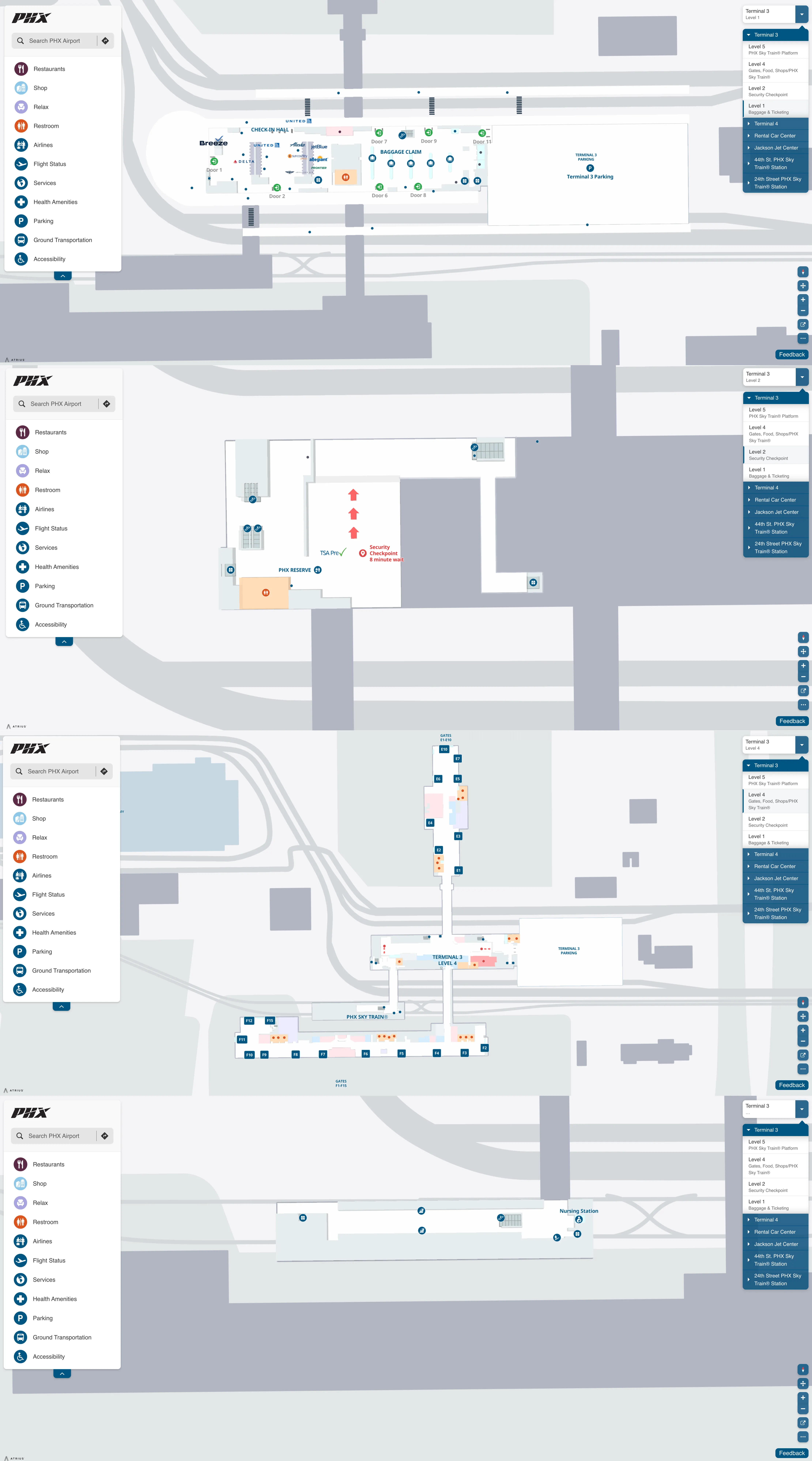
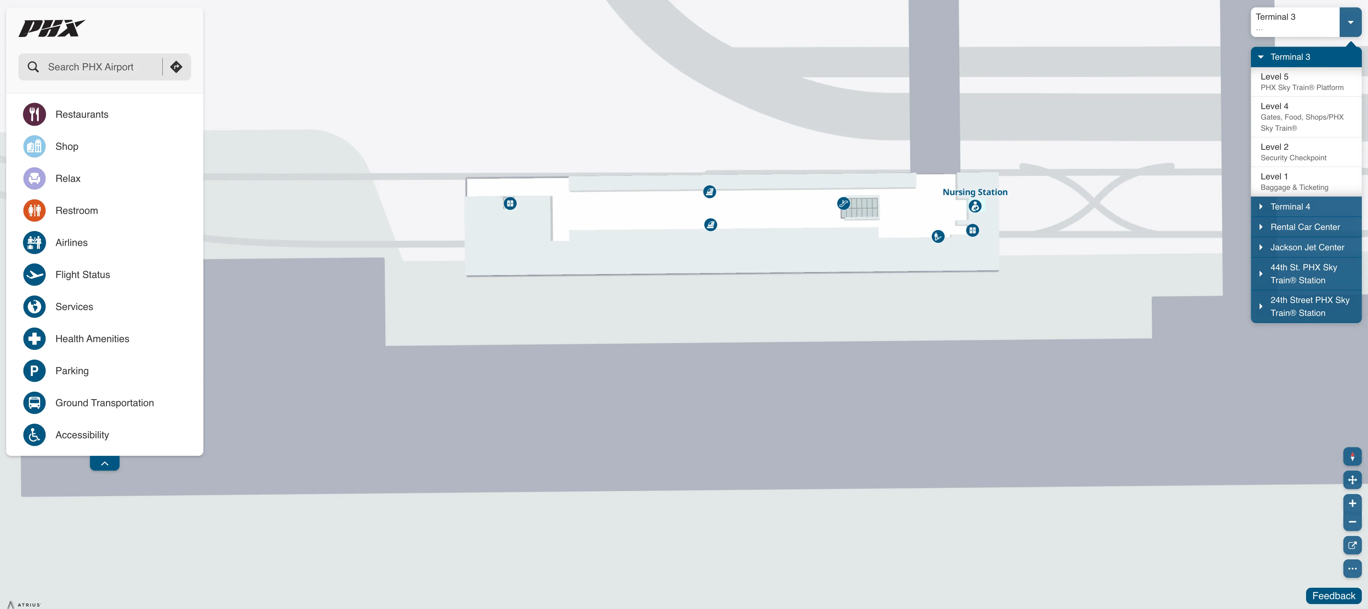
Phoenix Sky Harbor International Airport Terminal 3 Level 1 Baggage And Ticketing Map 2025
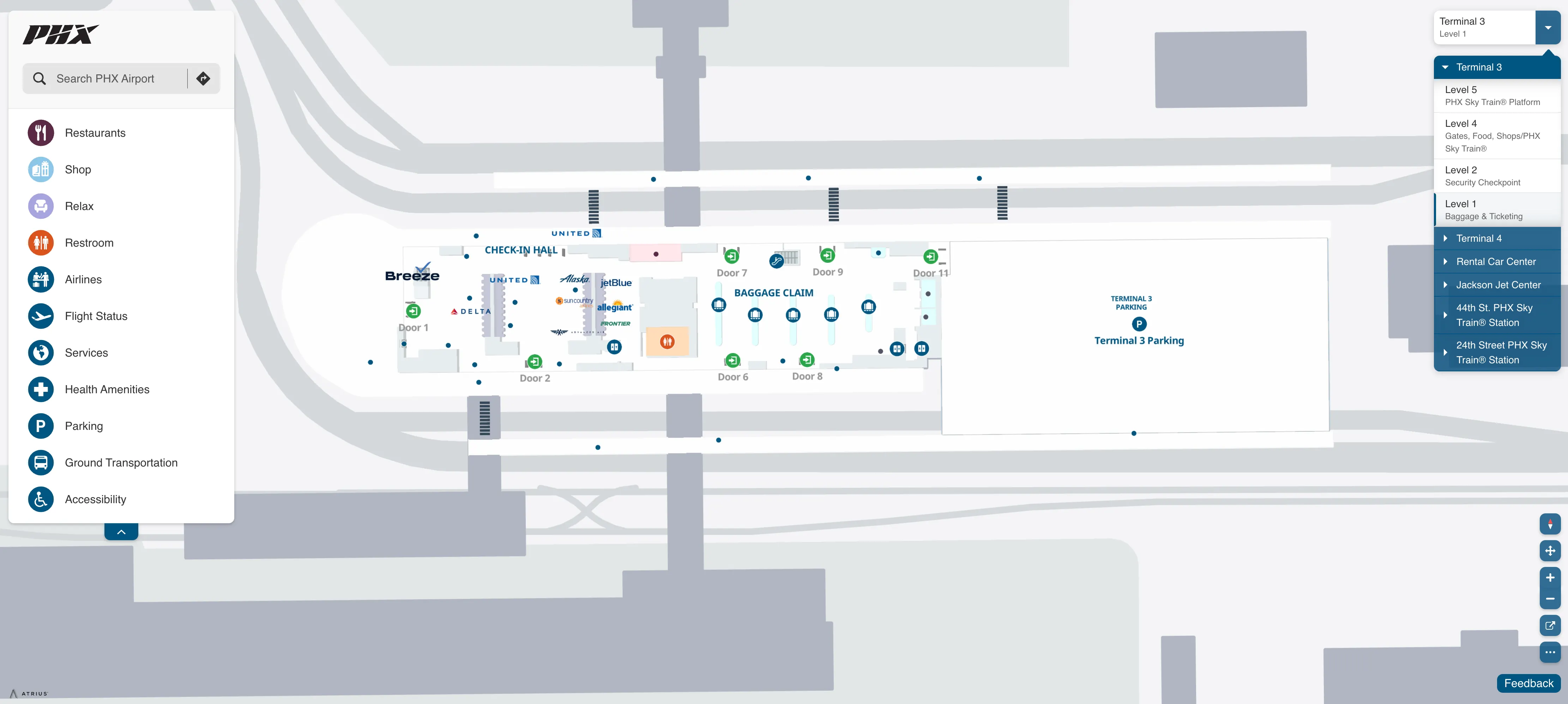
Phoenix Sky Harbor International Airport Terminal 3 Level 2 Security Checkpoint Map 2025
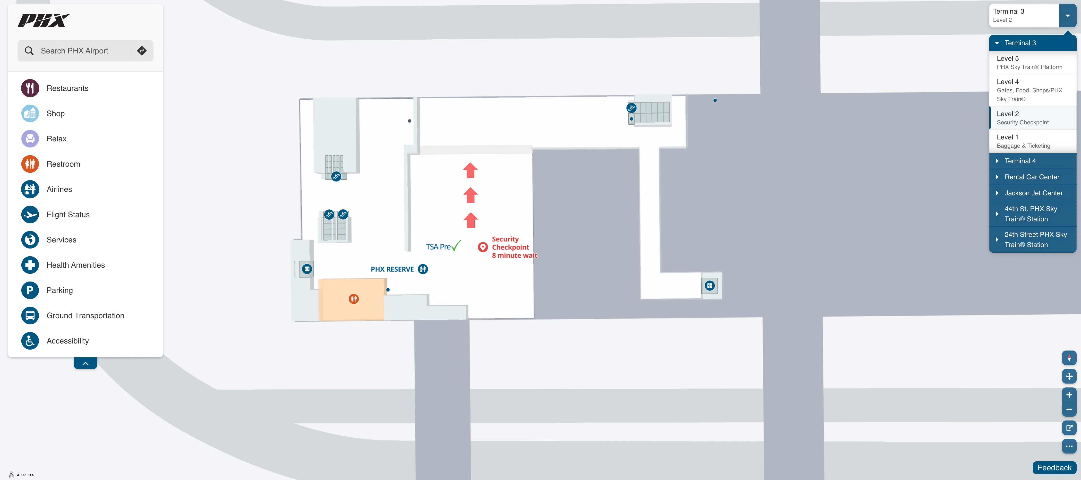
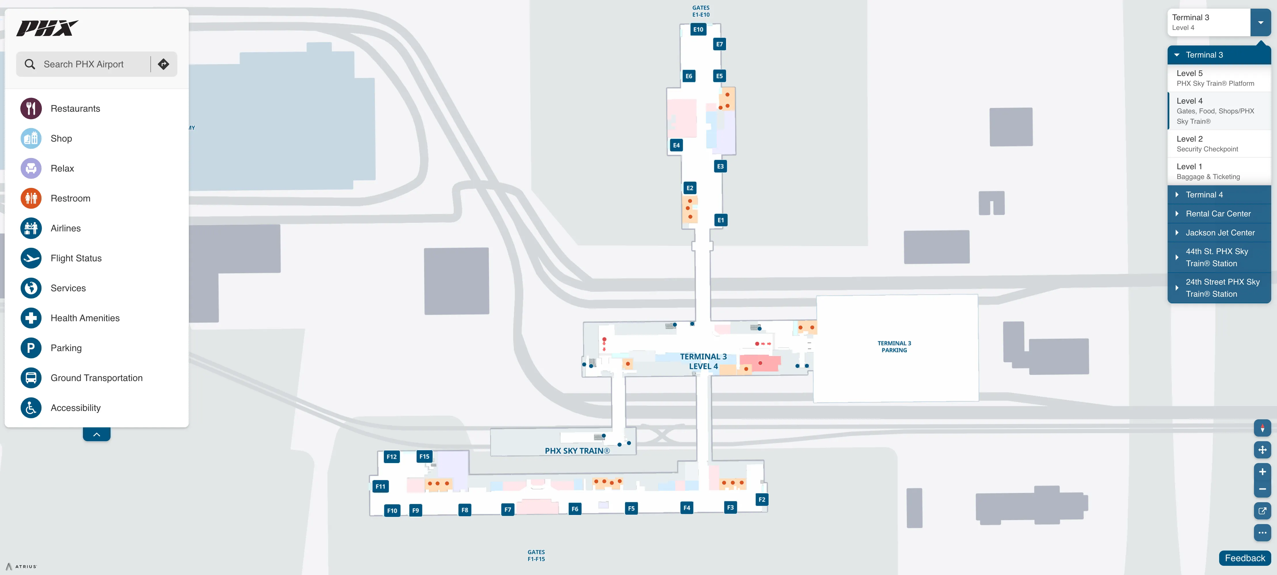
Phoenix Sky Harbor International Airport Terminal 3 Level 4 SkyTrain Map 2025
Phoenix Sky Harbor International Airport Terminal 3 Level 5 SkyTrain Platform Map 2025
2026 Phoenix Sky Harbor International Airport Terminal 3 Map Guide
Where is the precise “decision point” (map landmark) on the Terminal 3 approach where drivers must commit to the correct curbside lane before the curves make it irreversible?
The decision point is the Terminal 3 lane-split on E Sky Harbor Blvd immediately after you pass the Terminal 4 off-ramps, where an overhead gantry for “Terminal 3” sits beside a concrete median that forces a North-vs-South commitment. Once you flow past that split, there’s no practical cut-through inside the Terminal 3 loop without exiting and re-circling.
| Map landmark / cue | What to do | What it commits you to |
|---|---|---|
| Just past Terminal 4 off-ramps on E Sky Harbor Blvd | choose lanes before the curve | irreversible North vs South curb entry |
| Overhead “Terminal 3” gantry at the split | read door plan before you arrive | North curb (odd doors) vs South curb (even doors) |
| Concrete median at the bifurcation | don’t expect a late merge | forced loop + full recirculation if wrong side |
What is the exact map boundary of the Terminal 3 rideshare rule: “south outer curb minus the far east end” (i.e., where does the excluded zone begin)?
The excluded zone begins at Door 6 on the South outer curb, with rideshare pickups effectively allowed only west/central of that point (Door 2 and Door 4). From Door 6 eastward—past Door 8 to the terminal’s east tip—TNC drivers are typically blocked by the geofence and the curb is functionally reserved for other commercial operations.
| South outer curb segment | Door anchors | Rideshare status |
|---|---|---|
| West + central | Door 2, Door 4 | ACTIVE |
| Far east end start | Door 6 | PROHIBITED begins |
| Far east end continuation | Door 8 → east tip | PROHIBITED |
Where is the north outer curb, far east end rideshare pickup area located relative to door numbers in Terminal 3?
The north outer curb rideshare pickup area is at the far east end outside Door 9 and Door 11 on Terminal 3’s north side. That placement means the pickup zone sits past the mid-terminal core and closer to the east tip of the building, so travelers exiting at west-side doors must walk the length of the north frontage to reach it.
- Outside Door 9 on the north outer curb
- Outside Door 11 on the north outer curb
- Far east end of the Terminal 3 north loop (outer curb island)
What is the walking distance (in feet/meters) from Terminal 3 baggage claim doors to the closest Terminal 3 rideshare pickup curb segment?
Walking is about 200–300 feet (roughly 60–90 meters) from the central baggage claim area to the closest active rideshare pickup segment on the South outer curb near Door 2. That’s why Door 2 becomes the default meetup: it’s the shortest inside-to-curb path that still lands you inside the working TNC geofence, without forcing you toward the Door 6–Door 8 exclusion stretch.
| Start → end | Approx. distance | Practical meet anchor |
|---|---|---|
| Central baggage claim (Level 1) → South outer curb | 200–300 ft / 60–90 m | Door 2 (best), Door 4 (backup) |
What is the shortest walking route (step-by-step on the map) from Terminal 3 baggage claim to the PHX Sky Train entrance?
The shortest route is the interior path that goes from Level 1 baggage claim to the central vertical core, then straight up to Level 4 and across the Sky Train bridge. Staying inside avoids the curbside crosswalk islands and keeps you aligned with the only direct connection to the elevated station.
| Step | Map anchor | What you do |
|---|---|---|
| 1 | Central baggage claim hall (Level 1) | move to the middle of the atrium |
| 2 | Central elevator / escalator bank | go up to Level 4 (skip curbside exits) |
| 3 | Level 4 processor lobby | follow “PHX Sky Train” overhead signs |
| 4 | Pedestrian bridge entrance | cross the bridge to the Sky Train platform |
What is the shortest drivable loop (map route) from the cell phone lot exit to the Terminal 3 correct curbside segment for pickup (minimizing re-circling)?
The shortest loop is the East Cell Phone Lot → E Sky Harbor Blvd westbound return path that bypasses Terminal 4 curb exits, then re-enters the Terminal 3 approach for a fresh North/South commit. This minimizes re-circling because it keeps you inside the airport boulevard system instead of getting forced onto the highway.
| Route segment | Key landmark | Navigation intent |
|---|---|---|
| Exit East Cell Phone Lot | lot exit to return artery | rejoin airport circulation |
| Merge to E Sky Harbor Blvd (WB) | main terminal arterial | stable westbound approach |
| Bypass Terminal 4 exits | Terminal 4 off-ramps | avoid wrong-terminal capture |
| Follow “Terminal 3” signage | overhead gantries | set up correct split |
| Commit at T3 lane split | concrete median + curve | North curb (odd doors) or South curb (even doors) |
What is the exact curbside segment in Terminal 3 where arrivals doors transition to departures doors (east/west boundary on the map)?
No curbside segment marks an arrivals-to-departures transition at Terminal 3 because both functions share the same Level 1 curb along the full loop. Any door on either side can be used for drop-off or pickup, and the only consistent separation is door-numbering by curb side (odd doors North, even doors South) plus inner vs outer curb islands.
Terminal 3 operates as:
- Shared-use Level 1 curbside for arrivals and departures
- Vertical separation inside the building (baggage on Level 1, ticketing higher, gates/security higher)
- North/South curb selection as the real “boundary,” not east/west segmentation
Where are the terminal-to-terminal wayfinding nodes (map points: escalators/elevators/bridges) that most directly connect Terminal 3 interior to the PHX Sky Train platform?
The primary connector nodes are the central Level 1 vertical core (elevators/escalators) and the Level 4 Sky Train bridge entrance on the processor building. Using these two points keeps you fully inside until you step onto the dedicated bridge that spans the roadway to the station.
- Level 1 central core between the North/South curbside entry zones (main elevator bank)
- Level 1 adjacent escalator bank at the same central atrium node
- Level 4 processor lobby arrival point at the top of that vertical core
- Level 4 PHX Sky Train pedestrian bridge entrance (Sky Train–branded overhead signs)
What is the shortest Sky Train + walking route (map verified) from Terminal 3 to Terminal 4 when a traveler realizes they’re at the wrong terminal for an international departure?
The fastest recovery route is to go up to Level 4 in Terminal 3, cross to the PHX Sky Train platform via the bridge, ride one stop to Terminal 4, then enter Terminal 4 from its station level and continue to security. This avoids curbside re-circling and removes the “Terminal 3 vs Terminal 4” roadway split risk.
| Segment | Map anchor | Typical time |
|---|---|---|
| Vertical move | Terminal 3 central core → Level 4 | elevator/escalator dependent |
| Walk | Level 4 → Sky Train bridge → platform | ~3–5 minutes walking |
| Train | Sky Train Terminal 3 → Terminal 4 | ~2–3 minutes ride |
| Arrival | Terminal 4 station → terminal interior | shortest path to checkpoints |
Where is the first reliable flight-info checkpoint (map location) after entering Terminal 3 where a traveler can confirm they’re in the correct terminal/concourse before committing deeper?
The first reliable checkpoint is the Flight Information Display System (FIDS) bank on Level 1 just inside the curbside entry doors, positioned near the central escalator/elevator core. Checking the screens there lets you confirm airline, concourse (E vs F), and gate direction before you go upstairs to ticketing or security and get “pulled” deeper into the terminal.
- Level 1 entry zone immediately inside the curbside doors
- Adjacent to the central vertical core (escalators/elevators)
- Before committing to Level 2 ticketing or Level 4 security/gates
What is the walking distance from Terminal 3 security exit to the farthest gate in the Terminal 3 concourse (maximum-walk “worst case” gate)?
Walking is about 600–800 feet (roughly 180–245 meters) from the Level 4 security exit to the farthest “worst case” gate at the end of a concourse, typically Gate F15 at the tip of the South Concourse or Gate E10 at the tip of the North Concourse. The distance is largely linear, so time expands mainly with crowding and luggage speed rather than navigation complexity.
| From → to | Worst-case gate examples | Approx. distance |
|---|---|---|
| Security exit (Level 4) → concourse end | F15 or E10 | 600–800 ft / 180–245 m |
Where is the lowest-friction pedestrian path (map verified) from Terminal 3 curbside to the PHX Sky Train that avoids crossing the highest-traffic curbside conflict points?
The lowest-friction path is the interior-only route from Level 1 curbside doors to the central vertical core, then straight up to Level 4 and across the PHX Sky Train bridge. This avoids the outer-curb islands and the curbside crosswalk “valves” that repeatedly stop traffic and concentrate pedestrians in conflict points.
- Enter Terminal 3 from the curbside door nearest the central atrium
- Go directly to the central elevators/escalators (Level 1 core)
- Ride up to Level 4 without exiting to curb islands
- Follow PHX Sky Train signs to the pedestrian bridge and platform
Which exact map locations in Terminal 3 are the highest-probability wrong-turn points caused by ambiguous signage/visual coding (spots most likely to misroute travelers)?
The highest-probability wrong-turn points are the Terminal 3 approach split on E Sky Harbor Blvd, the Level 1 curbside “Sky Train hunt” trap, and the South curb Door 8 rideshare dead zone. Each spot creates a strong but misleading mental model: “I can fix it later,” “the train must be outside,” or “any south door works for Uber.”
- E Sky Harbor Blvd just after the Terminal 4 off-ramps at the Terminal 3 lane split (median-enforced commit)
- Level 1 curbside exits where travelers step outside looking for the PHX Sky Train instead of going up to Level 4
- South side near Door 8 where riders wait in the TNC exclusion segment and drivers can’t legally/geofence-stop there
Where is the exact curbside pickup “meet point” (door + side) in Terminal 3 that minimizes the need for drivers to loop around the terminal?
The best meet point is the South outer curb at Door 2. Door 2 sits early in the South loop for inbound drivers, stays inside the active rideshare geofence, and reduces downstream exposure to the Door 6–Door 8 taxi/commercial zone that triggers missed stops and forced re-circling.
- South side, outer curb island
- Door 2 as primary meetup
- Door 4 as fallback if Door 2 is saturated