Palm Beach International Airport Map (Most Up-To-Date)
Palm Beach International Airport (PBI) runs as a single terminal with a straight, three-level “stack” (Arrivals Level 1, Gates/Checkpoint Level 2, Ticketing/Departures Level 3) feeding Concourses A, B, and C from one central atrium. Within South Florida’s West Palm Beach air hub, most paths are short—but the airport’s chokepoints (parking shuttles, rental shuttles, TSA overflow, and curb pickup zones) can flip fast at peak times because the true queue starts and level changes aren’t obvious on first glance.
Map Table
| Terminal | Key Airlines | Primary Function | Transfer Mode |
|---|---|---|---|
| Main Terminal (Concourses A/B/C) | American, Delta, JetBlue, Southwest | Check-in, security, gates, baggage claim | walk, escalator/elevator |
| Level 1 Arrivals | multi-airline baggage claim | baggage claim, rental counters, taxis/shuttles | outer curb, crosswalk |
| Level 3 Departures | multi-airline ticketing | check-in, curbside bag drop, rideshare | outer curb, vertical move |
| Economy Parking | all travelers | low-cost parking | shuttle loop, walk via Stop 5 |
Palm Beach International Airport Map Strategy
- Treat PBI as “small but fragile”: plan around the few nodes that break under peak demand—Economy shuttle waits, rental shuttle bay selection, bag-drop vs ticketing doors, and TSA overflow landmarks.
- Use Stop 5 as the Economy Parking pivot: if you can’t park near that axis, commit early to the shuttle so you don’t burn time walking across the lot and then backtracking to the bus.
- Assume rental cars are a two-step race: counters are in the Level 1 baggage-claim zone, but fleet access can require a shuttle from specific Level 1 outer-curb doors/codes—standing at the wrong pillar can mean the bus passes you.
- Read TSA and curb risk by landmarks and “no-go” rules: when lines spill, the real TSA queue start shifts into the Level 2 corridor near Starbucks; arriving passengers should not expect rideshare on Level 1 because pickup is routed upstairs to Level 3.
2026 Palm Beach International Airport Map + Printable PDF
Current 2026 routing at PBI still hinges on the same decision nodes: Economy Parking’s walkable “sweet spot” aligns with Bus Stop 5, while shuttle riders load at the Level 1 outer curb near the mid-baggage-claim doors. Rideshare pickup remains on the Level 3 outer curb (not arrivals), and TSA congestion behavior is still defined by the Level 2 corridor pinch near Starbucks.
Palm Beach International Airport Complete Terminal Map 2025-2026
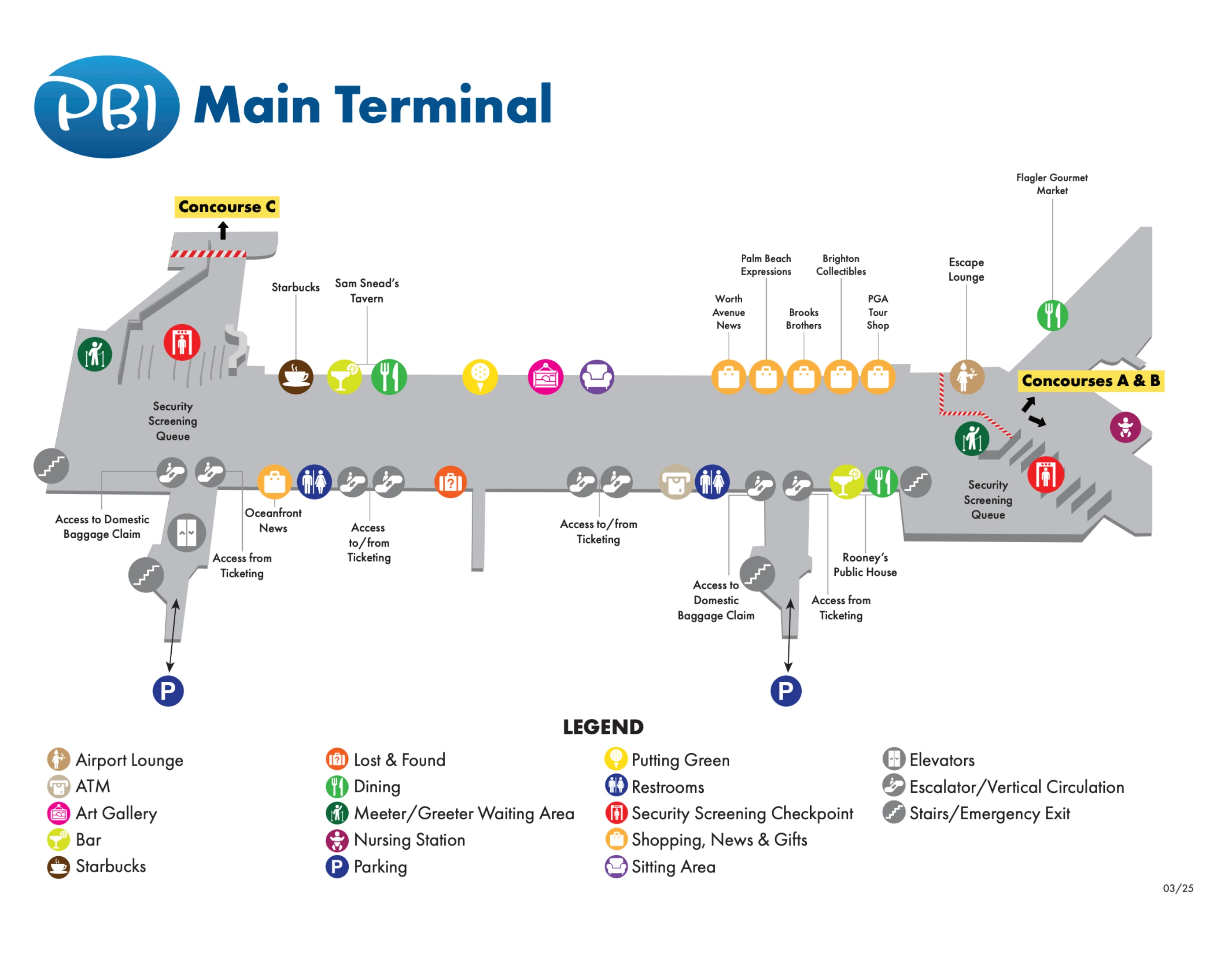
Palm Beach International Airport Main Terminal Map 2025-2026
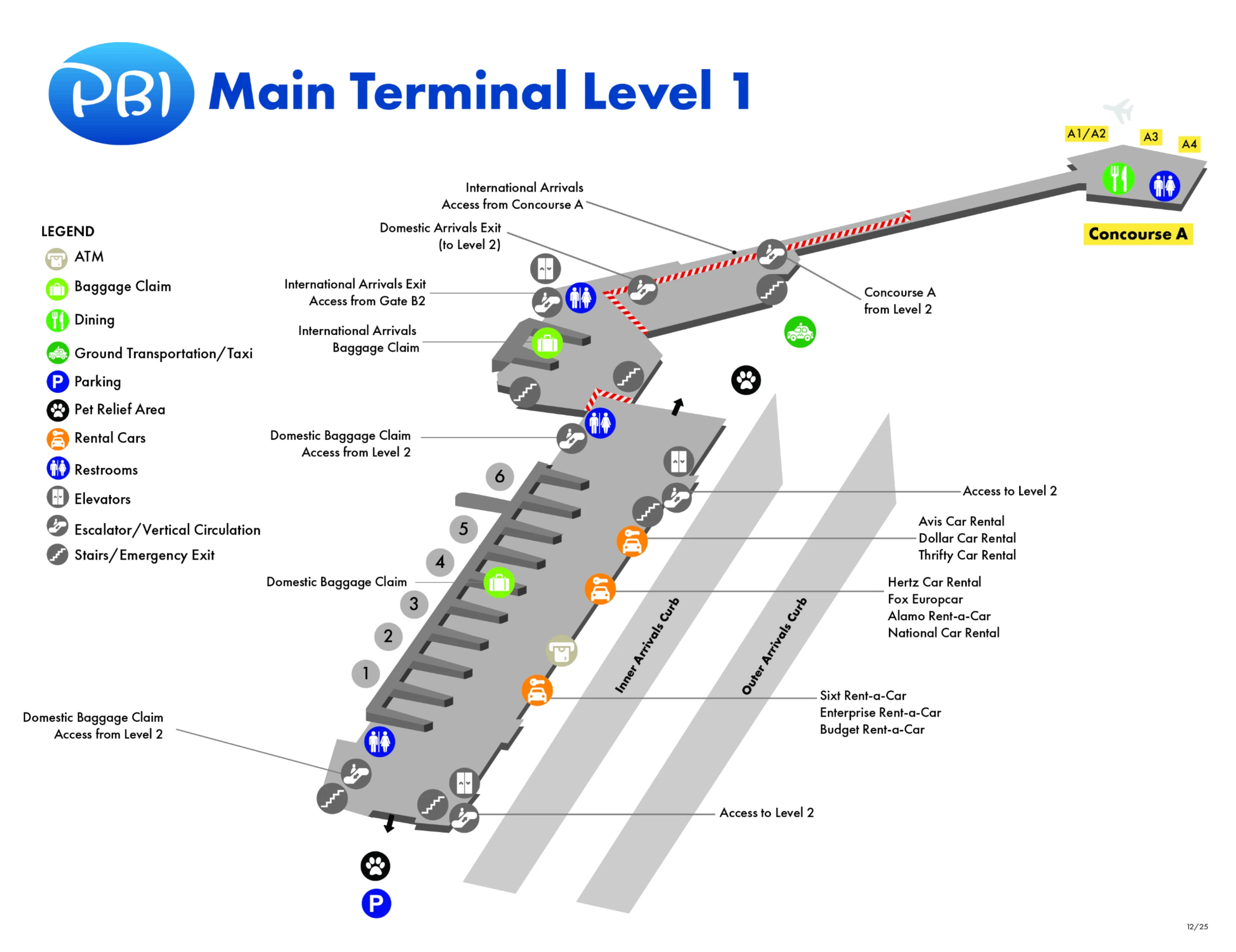
Palm Beach International Airport Main Terminal Level 1 Map 2025-2026
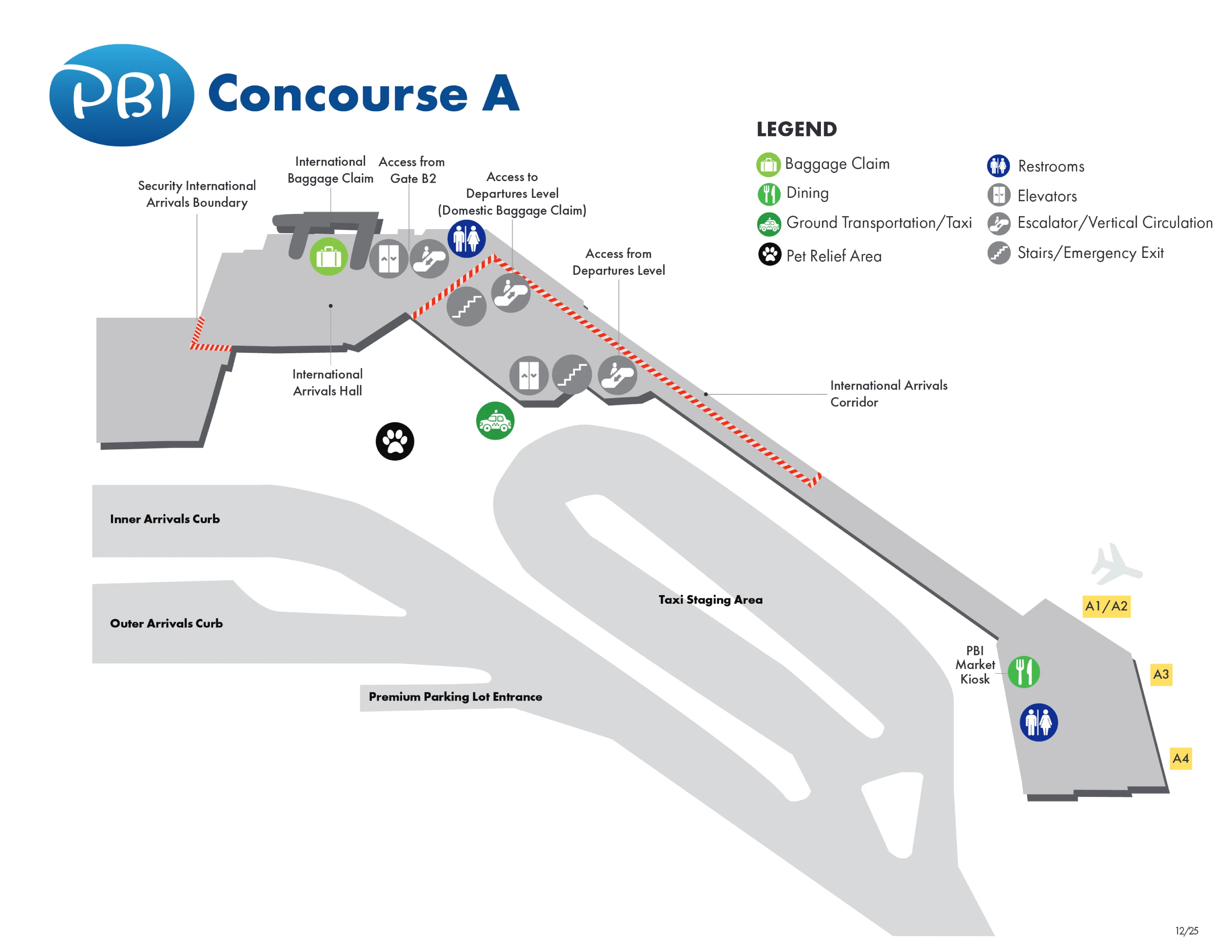
Palm Beach International Airport Concourse A Map 2025-2026
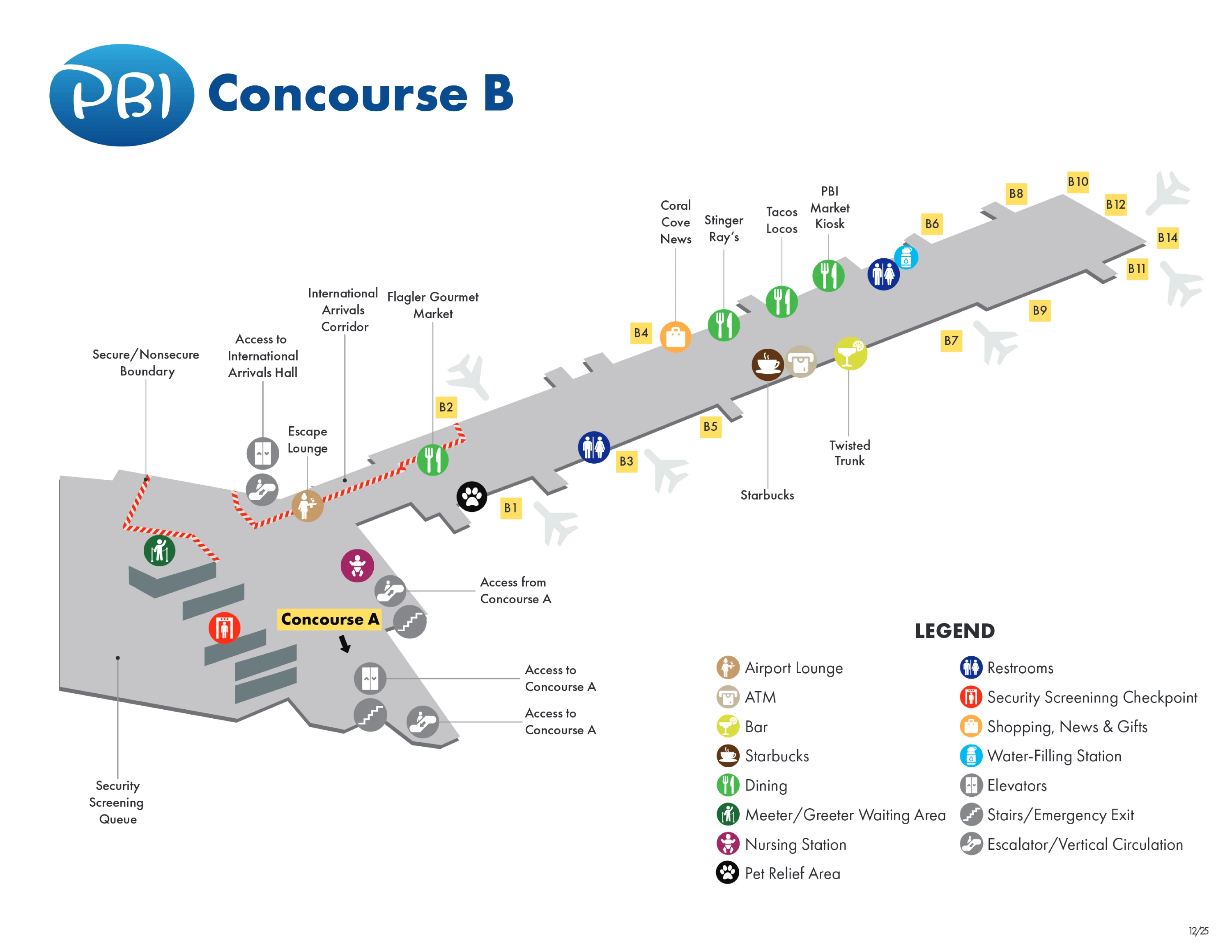
Palm Beach International Airport Concourse B Map 2025-2026
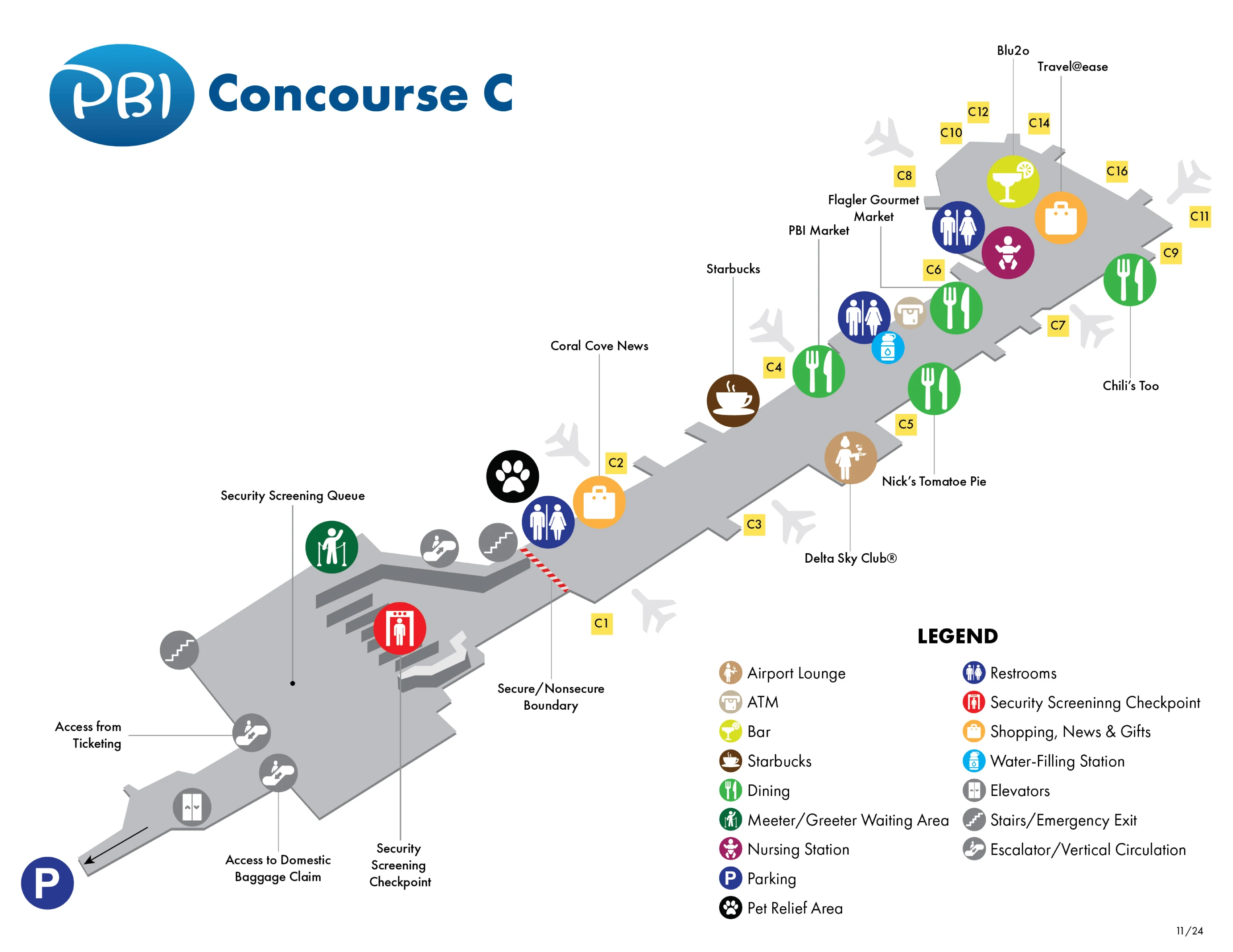
Palm Beach International Airport Concourse C Map 2025-2026
2026 Palm Beach International Airport Map Guide
What is the exact walking distance (feet/meters) from the Economy Parking Lot pedestrian exit to the nearest terminal entrance door?
The walk is about 1,300 feet (≈400 meters) from the Economy Lot’s pedestrian egress aligned with Bus Stop 5 to the nearest terminal entrance. That distance matches the airport’s “5-minute walk” claim under normal conditions and assumes you’re already parked in the Stop 5 sector.
The practical hinge is the Bus Stop 5 walkway opening—that’s where the direct pedestrian path begins. If you park nearer Stops 1–4 or 6–7, the extra lot traverse commonly adds ~800–1,000 feet (≈245–305 meters) before you even reach the Bus Stop 5 exit, turning the total into a longer 8–10 minute effort, especially with luggage and in rain.
Where is the Economy Parking shuttle stop located (exact curb/island position), and what terminal door is its primary drop-off?
The Economy Parking shuttle uses the Level 1 (Arrivals) outer curb/center-island zone, not the inner private-vehicle curb. Primary drop-off/pickup aligns with the baggage claim mid-core near Carousels 4–5, where riders exit the terminal and cross toward the outer curb shuttle island.
During busy periods, the key landmark is the Domestic Baggage Claim exterior crosswalk leading to the outer curb/center island. For low-traffic hours, the shuttle area is also tied to an on-demand call button at the stop—so the correct “island” matters because wait time can spike if you’re at the wrong curb line or door cluster.
From baggage claim exit, what is the exact walking distance to the rental car shuttle pickup point (measured along the real pedestrian path)?
The rental car shuttle pickup is typically a short walk of about 150–300 feet (≈45–90 meters) from the baggage claim exits to the Level 1 outer curb at the marked rental shuttle doors. The distance varies by which exit you use, because pickup is distributed along multiple door positions rather than one single bay.
Rental shuttles load at Doors 2, 4, or 6 on Level 1, so the most “exact” path depends on your nearest baggage-claim landmark: exiting closer to the central carousel bank generally puts you nearer Doors 4–6, while exiting from the opposite end trends toward Door 2. Use the pillar/door number signage outside baggage claim as your precision check—standing at the wrong door can mean a zone-restricted bus doesn’t stop for you.
Where does the rental car shuttle drop passengers, and what is the exact walking distance from that drop point to the rental counter hall entrance?
The rental car shuttle drops at the Rental Car Center curb outside the rental counter hall doors, with an about 150 feet (46 meters) walk from the bus drop point to the counter-hall entrance. The key is matching the shuttle’s assigned bay to the correct curb code before boarding back or waiting.
Shuttle boarding at the terminal side is tied to Level 1 outer curb Doors 2, 4, or 6 (often signed by curb codes such as 2C/2D), and the drop at the Rental Car Center is the mirrored “bus lane” outside the main counter building. Step off, follow the pedestrian sidewalk along the curb, and enter through the first main set of doors into the counter hall.
At PBI, where is the physical start of the TSA line during peak overflow (the exact corridor/landmark where the queue begins when it backs up)?
The TSA overflow queue starts in the Level 2 corridor by Starbucks when the stanchioned checkpoint area can’t contain the line. That Starbucks frontage acts as the hard landmark boundary where the “real” line begins once it backs up into the main circulation path.
During peak loads, look at the Starbucks entrance/signage on Level 2 near the security approach from the terminal atrium: if the crowd extends to or past Starbucks, join the queue at the back end nearest Starbucks, not at the stanchions up front. If you enter from the Level 3 ticketing side and descend/approach security, use Starbucks as your calibration point—queue density there means the line start has shifted out of the normal corral.
Where is the TSA PreCheck/CLEAR lane entrance relative to the standard checkpoint (exact side/landmark), so travelers don’t join the wrong queue?
The TSA PreCheck/CLEAR entrances sit immediately adjacent to the main checkpoint on Level 2, with the most reliable landmark being the CLEAR/PreCheck position across from the Concourse C security checkpoint entrance. That placement lets you confirm you’re at the expedited lane before you enter the stanchions feeding the general line.
Operationally, the expedited lanes can differ by concourse sector: the A/B side commonly supports CLEAR during morning-to-early-evening windows, while the Concourse C side keeps a longer staffed presence and places CLEAR/PreCheck visibly opposite the checkpoint entry. If you’re facing the checkpoint mouth, use the CLEAR podium as the “don’t-guess” marker—if you don’t see the podium and dedicated signage, you’re drifting into the standard queue.
Where is curbside airline bag drop positioned versus indoor bag drop (exact door/zone), so a traveler can choose the correct line without backtracking?
Curbside bag drop is on the Level 3 Departures curb aligned with each airline’s ticket counter zone, while indoor bag drop is immediately inside on Level 3 Ticketing at the carrier’s counter line. The curbside positions mirror the inside layout, so the fastest way to pick the right spot is to match your airline to the correct end of the departures curb before you unload.
Concourse C carriers (commonly Delta, JetBlue, Spirit) align to the east end of the Level 3 curb, while Concourse B carriers (commonly American, United, Southwest) sit toward the west/central departures curb. If you’re outside and can’t see your airline’s counter bank through the glass, you’re likely at the wrong curb segment—walk along Level 3 until you’re directly opposite your airline’s ticketing area, then commit to curbside or go inside to the counter line.
From the farthest common arrival gate to the designated rideshare/taxi pickup area, what is the exact walking time and distance along the signed route?
The longest common walk is from the far end of Concourse C (Gate C15) to Level 3 outer-curb rideshare pickup, and it typically runs about 2,800–3,600 feet (≈850–1,100 meters) and 15–20 minutes walking time before any baggage wait. That route is long at PBI not because of terminal sprawl, but because rideshare requires an “up-down-up” level change.
| Route leg | Signed path landmarks | Typical distance/time |
|---|---|---|
| Gate C15 → Concourse C base | pass Gates C6–C1, Pet Relief near C1 | ~1,200–1,600 ft / 5–8 min |
| Concourse base → terminal core (Level 2) | central atrium/security exit zone | ~600–900 ft / 3–5 min |
| Level 2 → Level 3 rideshare outer curb | elevators/escalators to Ticketing, cross to outer curb | ~1,000–1,200 ft / 5–7 min |
Taxi pickup is materially easier: it stays on Level 1 arrivals curb (past Carousel 6 area), eliminating the rideshare-only requirement to go up to Level 3.
What is the exact walking distance from the arrivals curb pickup area to the practical rail-connection pickup point used for transfers?
The rail-connection pickup is in the Level 1 Ground Transportation area on the outer curb, so the walk from a typical Level 1 arrivals curb pickup position is usually about 250–450 feet (≈75–140 meters) depending on which door you exit. The practical “transfer” landmark is the Ground Transportation bay signage outside baggage claim, not the rideshare zones upstairs.
Arrivals curb activity concentrates near the baggage claim exits, while the Tri-Rail/Palm Tran link is staged in the designated Ground Transportation sector along the same outer-curb line. Use the route maps posted inside Level 1 baggage claim to confirm the bay, then exit the nearest door and follow the curb signage to the shuttle stop—staying on Level 1 avoids the Level 3 rideshare detour entirely.
From Long Term Garage to the terminal, what is the shortest covered path (exact route + distance) that avoids shuttle reliance?
The shortest covered route is the Long Term Garage → Level 2 covered pedestrian bridge → terminal Level 2 atrium/security area, and it runs about 700–1,000 feet (≈215–305 meters) end-to-end from the garage’s bridge entry to the terminal-side doors. This is the “no-shuttle” path designed specifically to keep you under cover.
Walk to the Level 2 bridge connection inside the Long Term Garage (follow “Terminal / Pedestrian Bridge” signs), cross the enclosed bridge, then enter the terminal on Level 2 near the central core where you can either continue to security/gates or take escalators/elevators to Level 3 ticketing or Level 1 baggage claim. The key constraint is that the bridge is Level 2-only—if you aim for Level 1 curb first, you’ll lose the covered advantage.
Archive Palm Beach International Airport Map
Below are all historical map versions for Palm Beach International Airport. Each year includes the official map available for that period, presented as both WebP and PDF.
2025-2026 Palm Beach International Airport Map (Official 2025 Edition)