Marseille Provence Airport Map (Most Up-To-Date)
Marseille Provence Airport’s passenger layout splits across two separate buildings with a short outdoor gap: Terminal 1 (MP1) as the main full-service complex and Terminal 2 (MP2) as the low-cost unit. The footprint is compact but discontinuous, with the Gare Routière bus station acting as the central landmark between terminals. Within France’s Marseille-area aviation hub, the biggest navigation risk is assuming “Security = done,” then meeting a second control point or a forced landside terminal transfer.
Map Table
| Terminal | Key Airlines | Primary Function | Transfer Mode |
|---|---|---|---|
| Terminal 1 (MP1) | Air France, British Airways, Lufthansa | full-service, intl + domestic | walk via Gare Routière |
| Terminal 2 (MP2) | Ryanair, easyJet | low-cost, high-throughput | outdoor sidewalk, shuttle loop |
Marseille Provence Airport Map Strategy
- Treat “Security exit” as a midpoint, not the finish: Gates 30–66 can force a second queue at passport control after the duty-free funnel.
- Plan Terminal 1 ↔ Terminal 2 (MP2) as a landside transfer every time: outdoor walk, re-entry, and full re-screening are mandatory.
- Use the Gare Routière as your route validator between buildings; if you don’t pass the bus platforms, you drifted off the fastest pedestrian axis.
- For pickups and late/early trips, anchor to fixed curb nodes: taxi rank at Terminal 1 Arrivals curb; rideshare typically routed to PA/PB Minute (or P2 Minute) short-stay lots rather than the nearest door.
2026 Marseille Provence Airport Map + Printable PDF
Operational flow at 2026 Marseille Provence Airport still hinges on two realities: Terminal 1’s renovated core funnels you through duty-free into a gate-direction fork, and Terminal 2 remains a separate building with no airside link. Printing the 2026 map is most useful for verifying the post-security passport-control placement (Gates 30–66) and for locking in the exact landside walking line between MP2 and Terminal 1 via the Gare Routière.
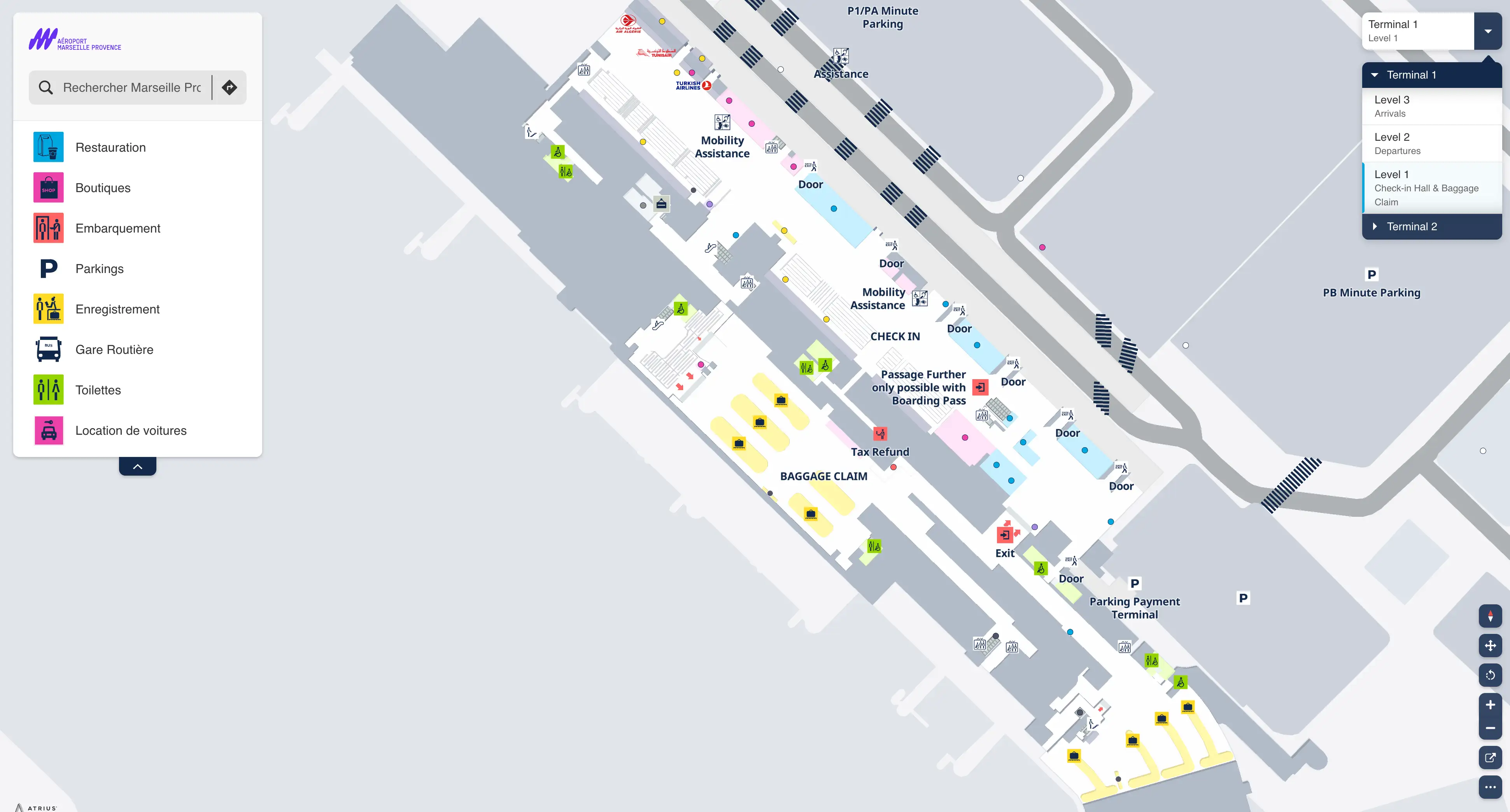
Marseille Provence Airport Terminal 1 Level 1 Map 2026
Marseille Provence Airport Terminal 1 Level 2 Map 2026
Marseille Provence Airport Terminal 1 Level 3 Map 2026
Marseille Provence Airport Terminal 2 Level 1 Map 2026
Marseille Provence Airport Terminal 2 Level 2 Map 2026
2026 Marseille Provence Airport Map Guide
What is the exact physical location (landmark + corridor) of the border-control checkpoint that appears after Security on the walk to certain gates?
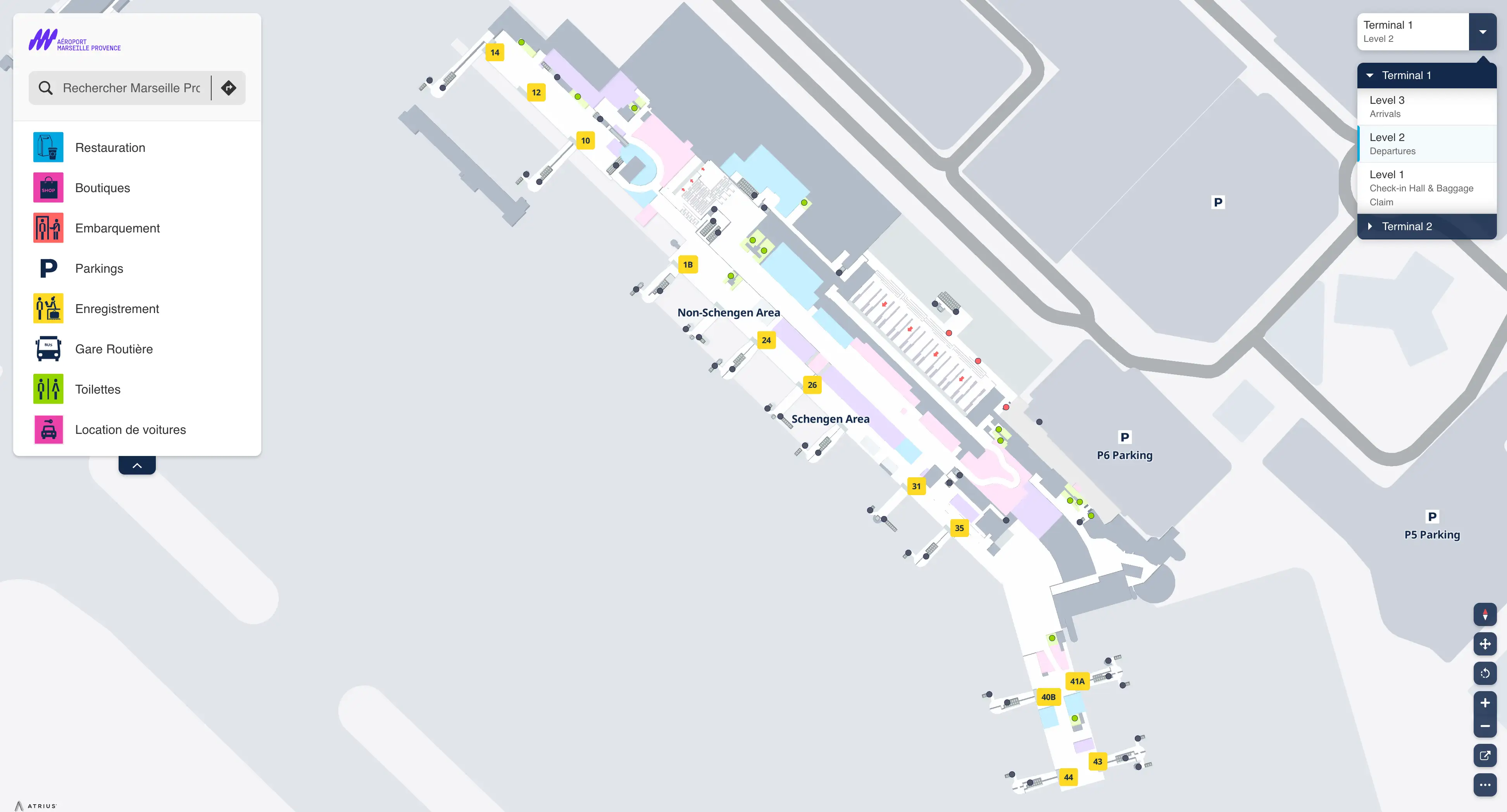
There is no bypass: passengers assigned to Gates 30–66 must clear the post-security passport-control checkpoint. The checkpoint sits immediately after Terminal 1’s duty-free funnel, at the central lounge “decision fork,” on the straight/slight-right corridor signed for non-Schengen gates.
From the Security exit on Level 2, walk the forced duty-free corridor (~40 m) until it opens into the central lounge. At that lounge node, Gates 10–25 peel left; stay straight/slightly right toward Gates 30–66 and you hit passport control about ~30 m ahead (around 1–2 minutes), after the corridor bends—so the queue often isn’t visible until the final corner.
What is the exact walking route (doors + sidewalk path) from Terminal 2 (MP2) arrivals exit to the Terminal 1 departures entrance used to re-clear Security?
Walking requires a landside outdoor transfer: exit MP2 Arrivals through the Level 1 sliding glass doors to the curb, then follow the paved sidewalk that parallels the airport access road toward Terminal 1. The route is confirmed by passing the Gare Routière bus station platforms, which sit directly between MP2 and Terminal 1.
From MP2 Arrivals curb, turn toward the larger Terminal 1 building and stay on the partially covered pedestrian sidewalk without cutting into parking lanes. Keep the bus platforms on your near side as you pass the Gare Routière, then continue straight to Terminal 1’s main ground-floor glass doors into the Check-in Hall (Halls A/B). Once inside, follow “Departures” signs to the escalators up to Level 2 Security for re-screening.
What is the measured walking distance (meters) from Terminal 2 (MP2) curbside exit to the Terminal 1 Security screening queue start?
The measured walking distance is approximately 225 meters from the Terminal 2 (MP2) curbside exit to the start of the Terminal 1 Security screening queue. This typically takes about 8–10 minutes of continuous movement when unimpeded.
The exterior sidewalk segment from MP2 curbside to Terminal 1’s main entrance is under 150 meters, with the Gare Routière bus station as the midpoint landmark. After entering Terminal 1 at ground level, the remaining distance comes from crossing the Level 1 check-in hall, reaching the escalators, ascending to Level 2, and walking to the security queue start—adding roughly another 75 meters before you hit the screening-line funnel.
Where exactly is the re-entry point into Terminal 1 departures after an outdoor transfer from MP2 (which entrance, and what signage should you follow)?
Re-entry uses Terminal 1’s main ground-floor glass doors into the Level 1 Check-in Hall serving Halls A/B, followed by “Departures” signage to the escalators up to Level 2 Security. This is the functional “departures re-entry” because there is no airside connection and you must re-clear security.
From the MP2 sidewalk approach (after passing the Gare Routière platforms), keep walking straight to Terminal 1’s primary landside entrance doors—these open directly into the public check-in and baggage-claim hall. Once inside, ignore gate signage and instead lock onto overhead wayfinding that reads “Départs / Departures,” which funnels you across the hall to the escalators/elevators for Level 2, where the security queue begins.
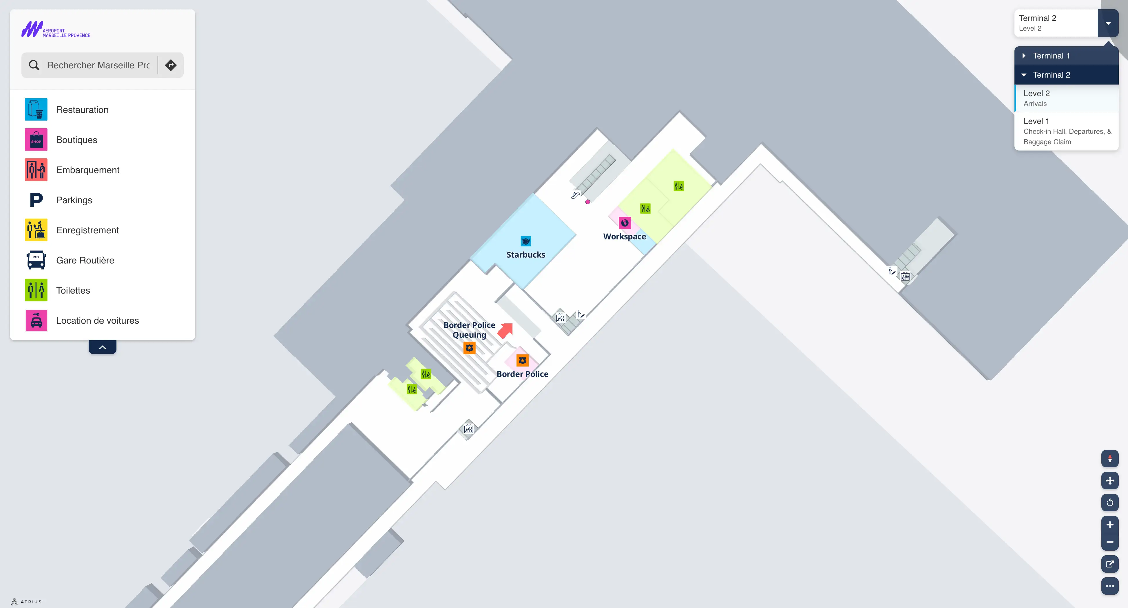
Where is the MP2 customs/control choke area physically positioned relative to MP2 gates (before the gate corridor vs a centralized checkpoint)?
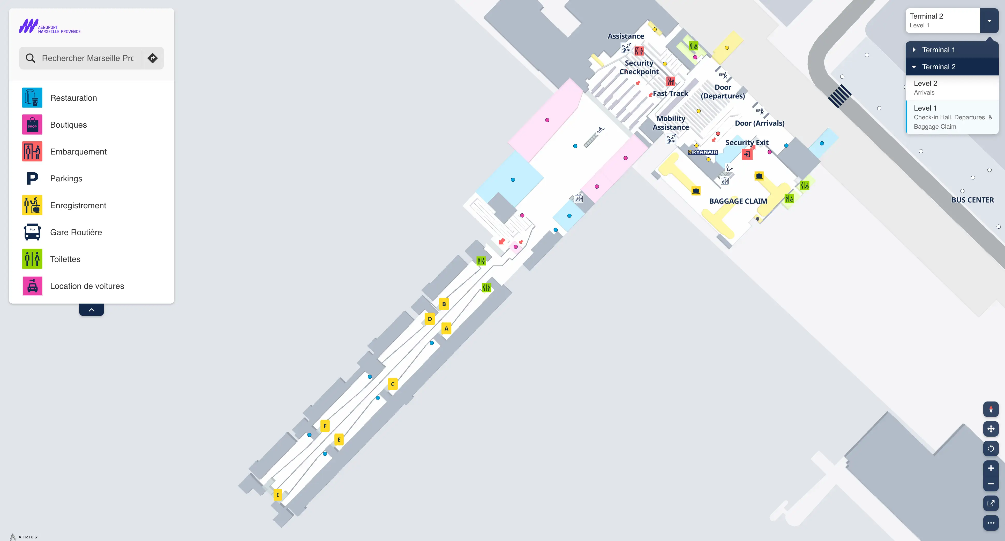
The MP2 customs/control choke area is a centralized checkpoint positioned before the primary gate corridor rather than being distributed near individual gates. It sits after the security checkpoint and the small duty-free area, creating a single compression point that all non-Schengen passengers must pass through on the way to the gates.
In MP2 departures flow, passengers move from curbside into Level 1 check-in, then into the adjacent primary security queue. After security, the path runs through the compact duty-free zone and then funnels into the centralized passport/control area (often with boarding-pass scan friction) that blocks access to the main gate corridor. The queue can spill backward because the building footprint is narrow and seating/dwell space is limited.
Where is the inter-terminal pedestrian connection (the primary walkway) located, and what is the first identifiable waypoint from each terminal that confirms you are on the correct path?
The primary inter-terminal pedestrian connection is the outdoor paved sidewalk that runs along the terminal frontage and parallels the main airport access road between Terminal 1 and Terminal 2 (MP2). The waypoint that validates you’re on the correct line is the Gare Routière (bus station) platforms, which sit directly between the two buildings.
From MP2, the first confirmation point is leaving Arrivals to the curb and immediately aligning with the sidewalk toward the larger Terminal 1 structure—then reaching the Gare Routière without cutting into parking lots. From Terminal 1, the first confirmation point is exiting at Level 1 toward the forecourt and walking in the direction of MP2 until you arrive at the Gare Routière platforms; once you’re alongside the bus bays, you’re on the correct transfer axis.
What is the exact location of the airport coach/bus stop area relative to Terminal 1 vs Terminal 2 (MP2), and which terminal exit gets you there with the fewest crossings?
The airport coach/bus stop area (Gare Routière) is located physically between Terminal 1 and Terminal 2 (MP2), on the central landside forecourt. The fewest-crossings approach is from Terminal 1 Arrivals on Level 1, which gives a direct, sheltered walk into the bus-station lanes without needing to navigate the MP2 curb geometry first.
From Terminal 1, exit Arrivals (Level 1) and walk toward the central forecourt to reach the Gare Routière platforms in roughly 50–60 meters. From MP2, you typically walk toward Terminal 1 along the main sidewalk for about 150 meters total; the bus station appears as the midpoint landmark on that line. Key bays anchor there: Shuttle A1 boards at Platforms 13/14, and Lebus+ 13 boards at Platform 5.
Where is the rideshare (Uber) pickup zone located on the airport road layout, and which terminal door puts you closest to the correct pickup lane?
Uber pickup is typically routed to the short-stay “Minute” parking areas outside Terminal 1 on the Arrivals (Level 1) side, most reliably the PA Minute and PB Minute lots (with P2 Minute as a secondary node). The closest door is a Terminal 1 Level 1 exit that lets you bypass the taxi curb and walk directly toward the Minute-parking boom barriers where app-based pickups stage.
Because drivers cannot legally idle at the terminal curb, the app may assign a pickup point that is not the nearest exit, but the fixed infrastructure that best matches rideshare loading is the PA/PB Minute zone. Exit Terminal 1 on Level 1, move away from the taxi rank frontage, and follow the app pin toward PA/PB Minute; if those are congested, expect the app to redirect to P2 Minute under the same short-stay logic.
What is the exact curbside location of the official taxi rank relative to the main terminal exits, and which side (arrivals vs departures level) is it actually on?
The official taxi rank is directly in front of Terminal 1’s main exits on the Arrivals level (Level 1). It is positioned immediately at the Terminal 1 Arrivals curb, roughly 10 meters from the doors, and functions as the regulated, static loading line for licensed taxis.
From Terminal 2 (MP2), the practical taxi procedure is to walk the inter-terminal sidewalk toward Terminal 1 for about 150 meters, using the Gare Routière as the midpoint landmark. The taxi rank is not reliably served by legal, on-demand curb hails at MP2; the sanctioned queue is at Terminal 1 Arrivals frontage, where vehicles line up at the curbside immediately outside the building.
From the point you exit Security in Terminal 1, what is the exact walking distance to the first decision fork where you either reach gates directly or get funneled into passport/border control?
The exact walking distance is about 80 meters from the Terminal 1 Security exit to the central lounge decision fork. This distance is composed of a mandatory ~40-meter duty-free funnel plus roughly another ~40 meters of open concourse to the lounge node where routing splits.
After Security on Level 2, you are forced through the duty-free retail corridor (about 40 m). The corridor then opens into the central lounge; continue a short additional walk across that open area until you reach the fork where Gates 10–25 peel left (Schengen) and the straight/slight-right corridor leads toward Gates 30–66 and the passport-control checkpoint. This is the last reliable spot to confirm your gate range before committing.
What is the shortest map-verified path from Terminal 1 gates back to landside (exit) that avoids dead ends, for passengers who must switch terminals?
The shortest path is to follow “Sortie / Exit / Baggage Claim” signage back from the Level 2 departures concourse to the primary one-way escalators down to Level 1 baggage claim, then exit through the final customs doors into the public Arrivals Hall. This avoids walking deeper toward gate fingers where you can dead-end into boarding-only corridors.
From the gates area, stay in the main spine of the departures concourse and track overhead signs for “Sortie / Exit / Récupération bagages.” Take the main down escalators/elevators to Level 1, walk past the baggage claim carousels, and pass through the last exit/customs doors to the landside Arrivals hall. From the front glass doors at curbside, run the outdoor sidewalk toward MP2, using the Gare Routière platforms as your waypoint that you’re on the correct terminal-transfer axis.
What is the exact location of the last reliable time buffer point (end of outdoor walk / start of Security line) for MP2 to Terminal 1 connections so travelers can sanity-check timing on the map?
The last reliable time buffer point is Terminal 1’s Level 1 Check-in Hall, immediately after you enter from the outdoor MP2-to-T1 walk and before you go up the escalators to Level 2 Security. This is the final spot where you can stop, reassess, and still take corrective action without being trapped in the security-and-controls funnels.
After passing the Gare Routière and entering Terminal 1 through the main ground-floor glass doors into the Check-in Hall (Halls A/B), pause there—restrooms, document recheck, and timing sanity-check all happen best at this node. Once you commit to the “Departures” escalators to Level 2, you’re inside the mandatory security queue flow, then the duty-free funnel, and potentially the high-volatility passport control for Gates 30–66, with no practical way to claw time back.