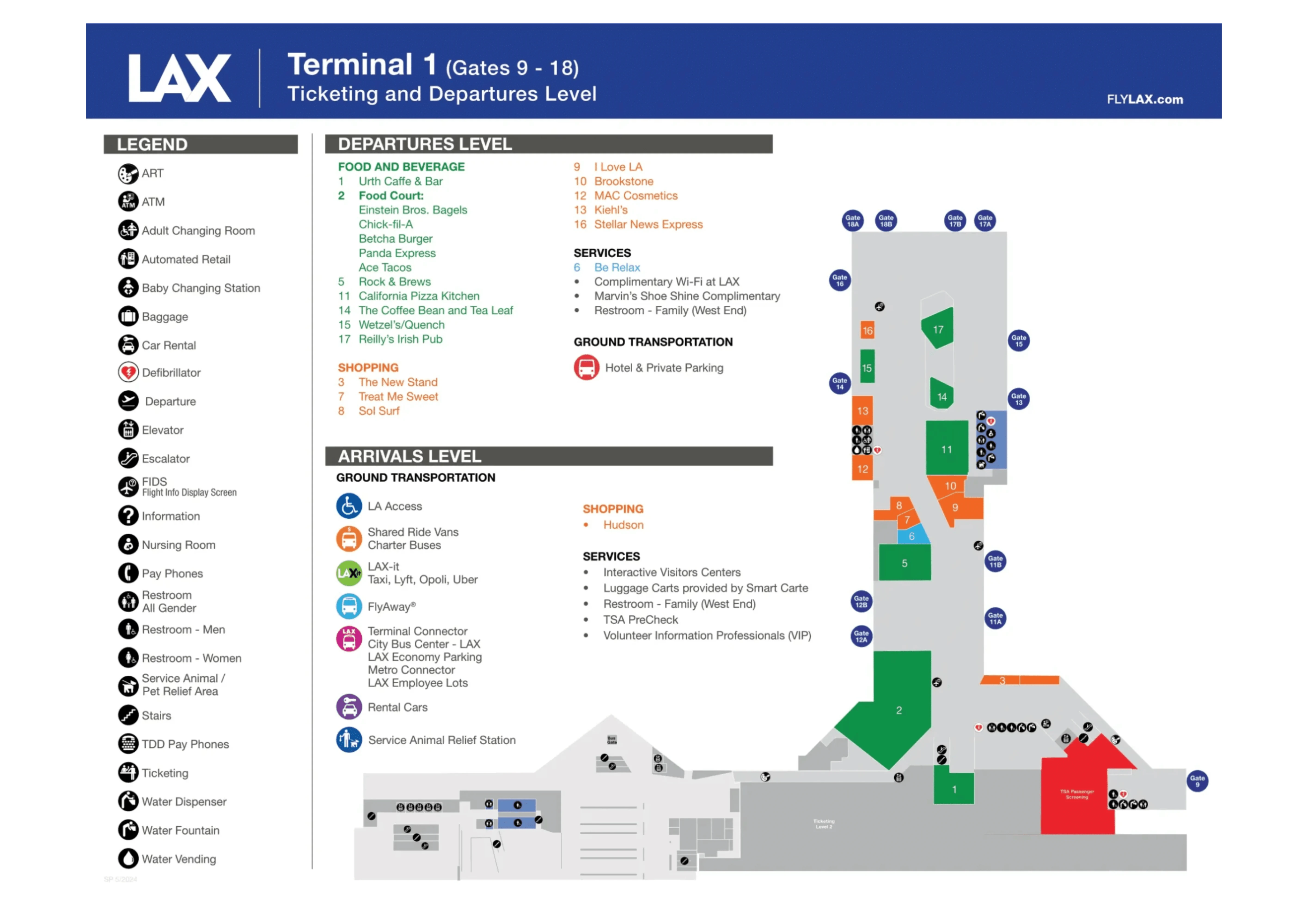
Los Angeles International Airport Terminal 1 Map (Most Up-To-Date)
LAX Terminal 1 is a compact, mostly linear terminal with two public levels (Departures above, Arrivals/baggage claim below) facing the World Way curb, plus a newer “Terminal 1.5” extension bridging the gap toward Terminal 2 within the main Los Angeles airport complex. The key spatial reality is the split footprint (T1 vs T1.5) and the bus ecosystem (LAX-it, inter-terminal, West Gates shuttle), where being on the wrong level or curb can trigger big backtracking.
Map Table
| Zone | Key nodes | Primary connections | High-risk decision points |
|---|---|---|---|
| Departures Level (L2) | Southwest ticketing, main TSA checkpoint, post-checkpoint concourse | Airside toward T2/T3/TBIT via T1.5 bridge | Main TSA vs T1.5 checkpoint choice, PreCheck lane side |
| Arrivals Level (L1) | baggage claim carousels, Doors L1-06 / L1-07, inner curb bus bays | LAX-it walk route, curbside shuttles | inner curb vs outer island curb, wrong stop crowding |
| Terminal 1.5 zone | glass-fronted extension, secondary checkpoint area, connector corridor | Airside bridge to T2, West Gates shuttle bus gate area | checkpoint closed-hours risk, West Gates vs “Terminal B core” confusion |
| East end curbside | LAX-it green signage cluster, crosswalk at Sky Way / World Way | LAX-it lot entrance | wrong-level exit, crosswalk miss, shuttle temptation |
Los Angeles International Airport Terminal 1 Map Strategy
- Treat Terminal 1 as two footprints: T1 (main Southwest lobby/checkpoint) vs T1.5 (connector facility). Default to the main T1 checkpoint unless you already know T1.5 is open and correct for your flight.
- Make every ground-transport map decision by level and curb: Arrivals (L1) is where LAX-it walking and most shuttle bays actually “work”; Departures (L2) cannot shortcut you to LAX-it.
- Don’t mix up bus types: green LAX-it vs blue inter-terminal/airline connections vs the airside shuttle that drops at Bradley West Gates (not the Terminal B central hall).
- Stay airside intentionally: follow Terminal 2/Terminal 3/Terminal B gate signage, and ignore “Baggage Claim/Exit” prompts at connector junctions to avoid accidental landside exits and re-screening.
2026 Los Angeles International Airport Terminal 1 Map + Printable PDF
In the 2026 operating layout described in the audit, Terminal 1 remains active with the Terminal 1.5 expansion functioning as both a connector toward Terminal 2 and a common source of “wrong entrance” mistakes when its checkpoint hours vary. LAX-it remains the default rideshare pickup system, and post-security connectivity is available—but distance and shuttle destinations (West Gates vs TBIT core) still create time-loss traps.
2026 Los Angeles International Airport Terminal 1 Map Guide
What is the exact, step-by-step walking route (and distance) from Terminal 1 baggage claim (arrivals level) to the LAX-it lot entrance?
Walking is about 300–400 yards (275–365 meters) and typically takes 3–5 minutes from Terminal 1 baggage claim to the LAX-it lot entrance.
| Step | Route node | Distance cue |
|---|---|---|
| 1 | Baggage Claim (Arrivals Level 1) | carousel hall center |
| 2 | Doors L1-06 or L1-07 exit | east end of baggage claim frontage |
| 3 | Sidewalk eastbound, follow green “LAX-it” arrows | terminal frontage sidewalk |
| 4 | Sky Way / World Way pedestrian crosswalk | controlled intersection |
| 5 | LAX-it lot entrance | immediately across intersection |
Where exactly is the green LAX-it shuttle stop at Terminal 1 on the lower/arrivals level, relative to the nearest baggage carousel doors?
The green LAX-it shuttle stop at Terminal 1 is on the Arrivals (Lower) Level inner curb, immediately outside the east end of the baggage claim exits, closest to Doors L1-06 and L1-07.
- Arrivals Level inner curb lane (closest roadway to the terminal doors)
- Outside baggage claim Doors L1-06 / L1-07 (east end of the lower-level frontage)
- Green “LAX-it” signage and green stop/pillar wraps at the waiting zone
- Same sidewalk segment that leads directly to the Sky Way / World Way crosswalk toward the LAX-it lot entrance
Where is the inter-terminal shuttle stop at Terminal 1 for Terminal B (TBIT), and which curb position (inner/outer/median-side) is the correct waiting zone?
The Terminal B (TBIT) inter-terminal shuttle stop at Terminal 1 is on the Arrivals (Lower) Level outer island curb (median-side), not the inner curb by the terminal doors.
- Lower/Arrivals Level (L1), cross the service road to the center island where the blue “LAX Shuttle & Airline Connections” signs are posted
- Correct waiting zone: outer island curb on the center median (the island across from Terminal 1), not the inner curb next to baggage-claim doors
- Landmark anchor: look for the blue bus-stop signage cluster roughly mid-frontage of Terminal 1 (often around Pillar 1D–1F area, construction-dependent)
- Common failure mode: waiting at the inner curb where green LAX-it shuttles load, then realizing the Terminal Connector/A Route boards across at the island
Where is the post-security connector path start point inside Terminal 1 that leads toward Terminal 2/3 and Terminal B, and what is the shortest mapped route to reach it from the main T1 concourse?
The post-security connector toward Terminal 2/3 and Terminal B starts near the Bus Gate corridor at the Terminal 1.5 interface, around the connector zone by Gates 12A–21A.
| Segment | From | To | Landmark cue |
|---|---|---|---|
| 1 | Terminal 1 main TSA exit | main T1 concourse spine | central concourse after screening |
| 2 | main T1 concourse spine | corridor toward Gates 12A–21A | follow “Terminal 2 / All Gates” signs |
| 3 | Gates 12A–21A interface area | Bus Gate / T1.5 connector corridor | bus-gate area adjacent, connector feels like a bridge/expansion |
| 4 | T1.5 connector corridor | Terminal 2 secure zone | signage for “Terminal 2” continues, no need to exit landside |
What is the exact walking distance from Terminal 1 security exit to the first major wayfinding decision point that confirms you’re headed toward Terminal 2/3 (airside)?
The audit doesn’t provide a precise measured distance; it’s about a 3–5 minute walk (roughly 0.15–0.25 miles / 240–400 m) from the Terminal 1 security exit to the first “you’re on the T2/T3 path” decision point.
| Route slice | Start | Confirming decision point | Distance cue |
|---|---|---|---|
| Post-TSA to connector approach | Terminal 1 security exit | overhead signs pointing “Terminal 2 / All Gates” toward the T1.5 side | continuous corridor walk |
| Connector entry | main T1 concourse | Gates 12A–21A interface area near the Bus Gate corridor | subtle “bridge/expansion” feel |
| Hard confirmation you stayed airside | T1.5 connector corridor | first Terminal 2 gate-number environment (gate numbers shift into the 20s) | end of the 3–5 minute window |
Where is the Terminal 1.5 shuttle boarding point (inside the secured area), and what is the mapped drop-off location at Bradley West Gates?
The Terminal 1.5 airside shuttle boards at the Bus Gate area inside the secured connector corridor near the Gates 12A–21A interface, and it drops at the Bradley West Gates (Midfield Satellite Concourse, Gates 201–225) at the south end of the West Gates concourse on the lower level.
- Boarding point: post-security corridor at the T1 ↔ T1.5 interface, adjacent to the Bus Gate zone near Gates 12A–21A signage
- Key “do not assume” constraint: this bus is for Bradley West Gates, not the Terminal B central hall
- Drop-off: Bradley West Gates (Gates 201–225), south end of the concourse, lower level arrival/bus area
- Recovery landmark: escalators/elevators down to the underground tunnel that leads back toward the Terminal B central hall
What is the exact walking distance from the Bradley West Gates shuttle drop-off to the main Terminal B central hall (the “back-walk” people describe)?
The back-walk is roughly 1,000+ feet (300+ meters) from the Bradley West Gates shuttle drop-off to the Terminal B central hall, and it usually takes 15–20 minutes.
From the Bradley West Gates shuttle drop-off (West Gates, Gates 201–225), head to the escalators/elevators down to the underground connector tunnel. Follow the tunnel straight through the moving-walkway sections toward “Terminal B” signage, staying in the same corridor until it rises back up. The tunnel exits into the Tom Bradley International Terminal central hall (the Great Hall), not a gate corridor—so if you’re aiming for lounges/food in the core, this is the correct end point of the walk.
Where are the two Terminal 1 security checkpoint entrances located (downstairs vs “upstairs/1.5”), and what are their nearest identifiable landmarks on the public-side map?
Terminal 1 has two public-side security entrances: the main Terminal 1 checkpoint on the Departures level behind Southwest ticketing, and the Terminal 1.5 checkpoint in the newer glass-fronted facility between Terminal 1 and Terminal 2 (often accessed via the higher-level 1.5 lobby).
- Terminal 1 main checkpoint: Departures Level (Level 2), directly behind the main Southwest check-in counters and kiosk banks
- Terminal 1.5 checkpoint: in the Terminal 1.5 building between Terminal 1 and Terminal 2, entered from the Terminal 1.5 lobby area (the newer glass-fronted extension) and associated upper-level access (often described as Level 3)
- Common failure mode: walking toward the 1.5 lobby expecting an “always open” checkpoint, then backtracking to the main Southwest lobby checkpoint
Which Terminal 1 checkpoint has the dedicated TSA PreCheck lane, and where is the PreCheck queue entrance located relative to the main checkpoint entry?
The Terminal 1 main checkpoint has the dedicated TSA PreCheck lane, and the PreCheck queue entrance is typically on the left-hand side of the checkpoint when you’re facing the screening area from the public lobby.
The PreCheck banners are the key anchor: look for the blue TSA PreCheck signs before you enter the main serpentine queue. If you pass the left-side PreCheck opening and join the general queue, switching later usually means ducking out through stanchions or negotiating a barrier opening with a TSA officer. PreCheck is not consistently available at the Terminal 1.5 checkpoint even when that checkpoint is open.
What is the shortest mapped walking route from Terminal 1 arrivals to the Terminal 5 entrance (landside), including the exact crosswalk/parking-structure edges you must pass?
Walking landside via the central parking structures is the shortest mapped route, at about 0.6–0.7 miles (1.0–1.1 km) and roughly 10–15 minutes from Terminal 1 Arrivals to the Terminal 5 entrance.
| Step | From | To | Must-pass crosswalk / garage edge cue |
|---|---|---|---|
| 1 | Terminal 1 Arrivals (baggage claim exit to curb) | World Way crosswalk toward Parking Structure 1 (P1) | marked crosswalk directly opposite Terminal 1 to P1 pedestrian entry |
| 2 | P1 entry | inside Parking Structure 1 | follow pedestrian aisle to the interior walkway/elevator core (stay off the vehicle ramps) |
| 3 | P1 interior path | southbound through the central garage complex | continue along the garage’s interior pedestrian edge, trending toward P7/P6 (don’t follow the horseshoe sidewalk along World Way) |
| 4 | near Parking Structure 7 (P7) side | World Way crosswalk toward Terminal 5 | cross from the garage side back across the roadway at the Terminal 5-facing crosswalk |
| 5 | Terminal 5 curbside sidewalk | Terminal 5 entrance doors | stay on the terminal-front sidewalk to the main entry set |
What is the shortest mapped walking route from Terminal 1 (airside) to Terminal 6 (airside), and what is the total distance (to validate “45 minutes” claims)?
Walking Terminal 1 to Terminal 6 airside is a long U-shaped connector walk that typically takes 45+ minutes, at roughly ~2 miles (about 3.2 km) end-to-end.
| Segment | Airside route | Landmark cue |
|---|---|---|
| 1 | Terminal 1 → Terminal 2 | T1.5 connector corridor, “Terminal 2 / All Gates” signs |
| 2 | Terminal 2 → Terminal 3 | post-security connector into Terminal 3 gate environment |
| 3 | Terminal 3 → Terminal B | signed connector into TBIT secure area |
| 4 | Terminal B → Terminal 4 | follow “Terminal 4” connector signage, avoid “Baggage Claim/Exit” |
| 5 | Terminal 4 → Terminal 5 → Terminal 6 | continue the secure connectors along the horseshoe arc to Terminal 6 |
Where is the closest “wrong turn” risk point when walking Terminal 1 → Terminal B (post-security), where a traveler could accidentally head landside or into a dead-end corridor?
The closest high-risk wrong turn happens when you pass through Terminal 3 on the way to Terminal B, because “Baggage Claim/Exit” signage can pull you into a landside exit instead of the Terminal B connector.
Inside Terminal 1, stay committed to the corridor toward the Gates 12A–21A interface and follow “Terminal 2 / All Gates” signs into the connector. Once you enter Terminal 3, ignore any prominent “Baggage Claim” or “Exit” routing that leads toward escalators/downhill flows. Keep following “Terminal B,” “TBIT,” or Terminal B gate-range signage through the connector bridge so you don’t accidentally dump out to the Terminal 3 arrivals area and trigger re-screening.
From Terminal 1 check-in level, where is the fastest mapped path down to the arrivals-level curb for LAX-it pickup (including the nearest escalator/elevator bank)?
The fastest path is to use the central escalator/elevator bank near the baggage claim core to go from Terminal 1 Departures (check-in level) down to Arrivals Level 1, then exit at Doors L1-06 or L1-07.
From the Southwest check-in area on the Departures level, head toward the central vertical circulation (the main escalators/elevators that feed down to baggage claim). Go down to Arrivals Level 1 and walk through the baggage claim hall toward the east end of the frontage. Exit via Doors L1-06 or L1-07 to land directly at the green LAX-it wayfinding cluster and the sidewalk that leads to the Sky Way / World Way crosswalk for the LAX-it lot.
Where exactly are the Terminal 1 rideshare/ground-transport wayfinding signs concentrated, and which exit doors put you closest to the intended shuttle bay?
Terminal 1’s rideshare/ground-transport wayfinding signs are most concentrated on the Arrivals (Lower) Level curbside frontage, and Doors L1-06 and L1-07 put you closest to the LAX-it (green) shuttle bay and the LAX-it walk route.
The densest cluster is at the east end of the lower-level baggage claim curb where multiple bus products overlap (green LAX-it and other ground-transport prompts), which is why it feels visually saturated. Exiting at Doors L1-06/L1-07 places you directly at the green “LAX-it” arrows and the sidewalk segment that immediately feeds the Sky Way / World Way crosswalk into the LAX-it lot. Exiting farther west increases the chance you follow the wrong curb flow or end up scanning multiple stop pylons before committing.
Archive Los Angeles International Airport Terminal 1 Map
Below are all historical map versions for Los Angeles International Airport. Each year includes the official map available for that period, presented as both WebP and PDF.
2024 Los Angeles International Airport Terminal 1 Map