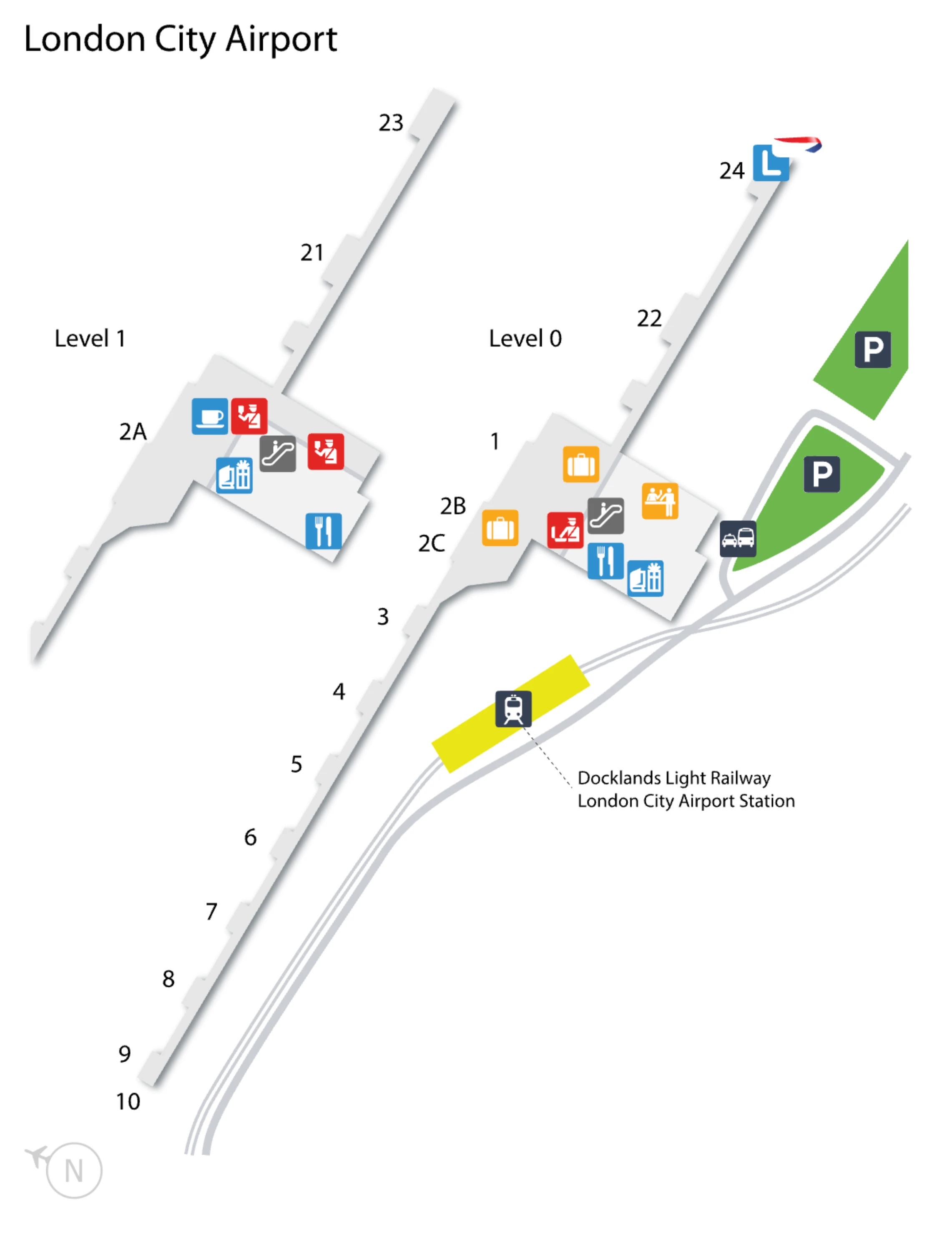
London City Airport Map (Most Up-To-Date)
London City Airport is a compact, single-terminal building with a stacked layout: ground-floor check-in and arrivals functions feeding one central escalator/elevator core up to first-floor security and the departure lounge. The footprint is short-range and linear, running along the terminal façade with airside piers extending from the central lounge area, so most navigation is a quick walk punctuated by one critical level change. Unlike the spatial buffers at the Heathrow hub, LCY’s tight vertical circulation makes queues the main navigation risk.
Map Table
| Terminal | Key Airlines | Primary Function | Transfer Mode |
|---|---|---|---|
| Single terminal | BA CityFlyer; easyJet; European carriers | Short-haul; business focus; fast turns | DLR; taxi rank; paid drop-off; Short Stay |
London City Airport Map Strategy
- Treat the central escalators as a point-of-no-return: look upstairs first (top landing) before committing your whole party and bags to the ascent.
- When security surges, expect metering at the base of the escalators and overflow along the first-floor mezzanine bridge overlooking check-in; don’t assume the line is “only upstairs.”
- In the departure lounge, plan around the silent-airport behavior: the densest seating forms by the main FIDS screens near the retail core, not evenly across the piers.
- At curbside, decide before the ANPR gantry: once you pass the charged entry point, the short walk inside can still fail if check-in or security backlogs spill toward the doors.
2026 London City Airport Map + Printable PDF
London City Airport still operates as a single-terminal, “fast when flowing” airport where the critical map layer is vertical: ground-floor check-in feeding one central escalator bank to first-floor boarding-pass gates and security. The printable win is knowing exactly where queues start and where they spill, so you don’t commit to an escalator ascent or curbside drop-off with no easy reset.
2026 London City Airport Map Guide
Where is the physical start point of the security queue (first stanchions) relative to the main entrance doors and the escalators?
The security queue starts at the top landing of the central escalators on the first floor, immediately in front of the automatic boarding-pass scanner gates. From the main entrance doors, you cross the ground-floor check-in hall to the central escalator bank, ride up, and step off directly into the feeder space where the first stanchions form in front of the e-gates.
Under normal flow, the first fixed queue geometry appears on the first-floor landing, not downstairs. The “start” is effectively anchored to the escalator egress: the stanchions sit within a few steps of where you arrive, before the line feeds through the boarding-pass scanners and then into the X-ray lanes.
When the security line reaches “back to the escalators,” which exact corridor/edge is used as the overflow queue lane?
The overflow queue is routed along the first-floor mezzanine bridge walkway that overlooks the ground-floor check-in hall, running away from the security e-gates and parallel to the void above the desks. When staff activate overflow, the line “folds back” along this bridge edge rather than spilling onto the escalator steps.
The critical reference point is the escalator top landing: overflow begins there, then extends along the gallery-style corridor that connects the landing to the central upper-level amenities. The lane is effectively the bridge-side edge of that mezzanine walkway, creating a long, linear queue with sightlines down to check-in; once it fills end-to-end, it can back up into the escalator egress zone.
Where is the vehicle drop-off zone entry point (the point of commitment into the charged area) relative to the Departures frontage doors?
The drop-off commitment point is at the western edge of the terminal forecourt, marked by an ANPR camera gantry, about 50 meters before the main Departures entrance doors. Once a vehicle passes under that gantry, it is committed into the charged drop-off lane that runs parallel to the terminal façade.
Approaching from the Connaught Road/roundabout direction, traffic is funneled into a dedicated forecourt lane split off by a hard traffic island. The lane then tracks tight to the building with minimal pavement between kerb and doors, so a driver who crosses the gantry is effectively locked into a single-file frontage run that ends at the Departures drop-off area outside the check-in hall doors.
What is the walking distance (meters) from the drop-off kerb to the first indoor check-in hall threshold?
Walking distance is about 20 to 35 meters from the drop-off kerb to the first indoor check-in hall threshold. This is the “zero-buffer” transition where the kerbside lane sits tight to the terminal façade with only a narrow pavement between traffic and the doors.
| Segment | Distance band |
|---|---|
| Kerb to terminal façade line | 5–8 m |
| Façade to first check-in hall threshold | 15–25 m |
| Total kerb to indoor threshold | 20–35 m |
What is the walking distance (meters) from the Docklands Light Railway platform exit to the Departures entrance doors?
Walking distance is about 100 to 150 meters from the Docklands Light Railway platform to the Departures entrance doors. The shortest path is constrained less by length than by level changes and barriers: platform movement to the central stair/lift core, down to the concourse, through the ticket barriers, then out onto the covered walkway to the terminal doors.
| Route segment | Approx. distance |
|---|---|
| Platform to stair/lift core | ~40 m |
| Concourse exit to terminal entrance | 25–35 m |
| Total platform-to-doors (incl. connectors) | 100–150 m |
Which Docklands Light Railway station exit/side yields the shortest path to the terminal entrance (the specific exit choice)?
The “Airport Entrance” (also signed “Terminal”) exit yields the shortest path to the terminal entrance. This exit leads straight from the station concourse into the covered walkway that points directly at the Departures doors.
The wrong choice is the Drew Road side, which faces away from the airport and drops you onto the local street network. From that side you must loop back around the station perimeter to regain the airport-facing walkway, typically adding about 5 to 10 minutes and breaking wayfinding momentum in wind and rain around the Royal Docks.
Where is the highest-density seating block in the departure lounge relative to the primary flight information screens?
The highest-density seating block sits in the central departure lounge cluster immediately around the main flight information display screens near the retail core. It forms in the zone serving the main west-pier gate run (around Gates 2b through 14) because passengers in a silent-airport setup stay inside the best line-of-sight cone to the master screens.
Density concentrates by the Duty Free and adjacent outlets such as WHSmith and the main café/bar units, where the primary screens are most visible and repeatedly checked. Seating further down the piers (toward the far gate ends) tends to remain underused until specific gates are posted, so the central block around the master screens becomes the default “waiting pen.”
What is the nearest toilet location to the central departure lounge seating cluster, measured by shortest walk path?
The nearest toilets to the central departure lounge seating cluster are the restroom block between Departure Gates 5 and 6. From the central seating around the retail hub and main screens, the shortest walk path is down the pier toward those gate-numbered positions.
This block sits just off the main circulation line, so it’s the quickest option without leaving the line-of-sight zone to the central screens for too long. If that block is busy or temporarily out of service, the next-most-practical alternative is the facility near Hithes and Caffè Nero, but it’s less obvious from the general seating rows around the retail core.
Where are the arrivals baggage belts positioned relative to the Arrivals landside exit doors (which direction, which hall segment)?
The arrivals baggage belts are positioned centrally in the baggage reclaim hall, roughly 25 to 35 meters before the landside exit doors. From the belts, passengers move forward a short distance to the Customs point and then continue straight on to the terminal’s landside exit.
The key landmark sequence is Passport Control → central belt area → Customs immediately beyond the belts → exit doors a short, direct walk after Customs. Because the hall is designed for throughput, the belts sit in the middle of the room rather than tucked into a side alcove, keeping the exit path short and visually direct once bags are collected.
Where is the baggage services / lost baggage desk positioned relative to the baggage belts (exact adjacency)?
The baggage services (lost baggage) desk is positioned at the rear edge of the baggage reclaim hall, behind the baggage belts and off the main forward flow to Customs and the exit. Relative to a passenger standing at the belts facing toward the landside exit, it sits back in the opposite direction, requiring you to turn away from the exit stream.
Because the natural movement is Passport Control → belts → Customs → exit, the desk falls outside the primary visual arc for most arriving passengers. The practical landmark cue is the belt zone itself: if you reach the belts and then keep drifting toward Customs, you’ll miss it; you need to scan the back/perimeter side of the reclaim room behind the carousels.
On disruption days where passengers are “held downstairs,” where is that downstairs holding area access point (stairs/escalator) relative to security?
The downstairs holding area forms at the base of the central escalators and lifts on the ground floor, directly below the first-floor security entry point. When the first-floor landing and mezzanine bridge reach saturation, staff stop the feed by blocking access at this ground-floor escalator approach.
The access point is the same vertical circulation core you’d normally use to go up to security, but instead of ascending you encounter barriers or a cordon at the escalator foot. The queue then snakes back into the ground-floor check-in hall aisles near the desks and nearby retail, using the open concourse as an emergency buffer when the upstairs line can no longer safely accept arrivals.
What is the exact pedestrian route from the Short Stay / pick-up parking to the Arrivals pick-up meeting point door (one continuous path)?
The route runs along the covered walkway from the Short Stay Car Park to the terminal forecourt, then straight into the ground-floor Arrivals entrance to the pick-up meeting point by the Arrivals exit doors. It stays mostly level, with a short slight slope as the walkway transitions from car park grade to forecourt grade.
From your parking bay, enter the dedicated covered walkway that runs the length of the car park on the terminal-facing side. Follow it to where it terminates at the forecourt, then cross the paved forecourt directly to the Arrivals doors. Once inside, continue a few steps to the waiting area by the international arrivals exit doors, which is the practical meeting-point landmark for pickups.
Where is the taxi rank positioned relative to the Arrivals doors (left/right, distance band, and the first visible landmark)?
The taxi rank is directly outside the Arrivals exit doors on the ground-floor forecourt, within about 10 to 20 meters of the doors, with the first visible landmark being the line of black cabs in the feeder lane against the terminal façade. You don’t cross a road or change levels; you exit and walk straight onto the pavement frontage.
The rank sits downstream along the same façade line as the drop-off area to reduce traffic conflict, so it presents as an immediate, linear curbside queue rather than a separate plaza. In peak arrivals, the taxi line can extend along the narrow pavement, but the visual cue remains the same: Arrivals doors → immediate frontage pavement → black cabs staged in a single-file pickup lane.