Lester B. Pearson International Airport Terminal 3 Map (Most Up-To-Date)
YYZ Terminal 3 is a long, linear terminal with three working passenger levels: Arrivals on Level 1, Departures processing on Level 2, and the Sheraton/Terminal Link connector on Level 3. The building “looks” centralized from the curb, but functionally splits into two separate sterile systems before security (US A Gates vs. Domestic/International B/C). Within Toronto’s main airport complex, the fastest navigation comes from committing early to the correct checkpoint, door, and level.
Map Table
| Level | Security Split | Ground Pickup Logic | Terminal Transfer |
|---|---|---|---|
| Level 1 | arrivals exit only | Door D → Inner curb taxis; Outer curb rideshare | vertical up to Level 3 |
| Level 2 | A vs B/C decision point | departures drop-off doors 1–8 | Link Train access via Level 3 |
| Level 3 | landside only | Sheraton bridge | Terminal Link platform |
Lester B. Pearson International Airport Terminal 3 Map Strategy
- Treat “A vs B/C” as the first irreversible choice: US flights must use the A-gates checkpoint on the west end, while Domestic/International use the central B/C checkpoint; the wrong line can force a full exit and re-screen.
- Neutralize security volatility by walking to the checkpoint perimeter first, then finding the true queue start (where stanchions and staff are actually inducting), not where crowds are clustering in the hall.
- Use door/column precision for pickups: exit via Door D on Level 1, then cross to the Outer Curb rideshare island and stand at the assigned pillar (C24–C30 range) so drivers don’t cancel while circling.
- Prevent terminal-transfer backtracking by “going up for trains”: from Arrivals or Departures, follow Sheraton/Terminal Link signs to Level 3, cross the hotel bridge, and enter the Link Train platform from the mezzanine.
2025 Lester B. Pearson International Airport Terminal 3 Map + Printable PDF
Terminal 3’s core navigation in 2026 still hinges on the same fixed “hard stops”: two different security entrances (A vs B/C), immediate US preclearance after A-gate screening, and rideshare pickups pushed to the Outer Curb by zone/pillar codes. Printing a map is most useful when it’s marked with your exact door and level targets before you arrive.
Lester B. Pearson International Airport Terminal 3 Level 1 Arrivals Map 2025
Lester B. Pearson International Airport Terminal 3 Level 2 Departures Map 2025
Lester B. Pearson International Airport Terminal 3 Level 3 Arrivals and Transfer Map 2025
2026 Lester B. Pearson International Airport Terminal 3 Map Guide
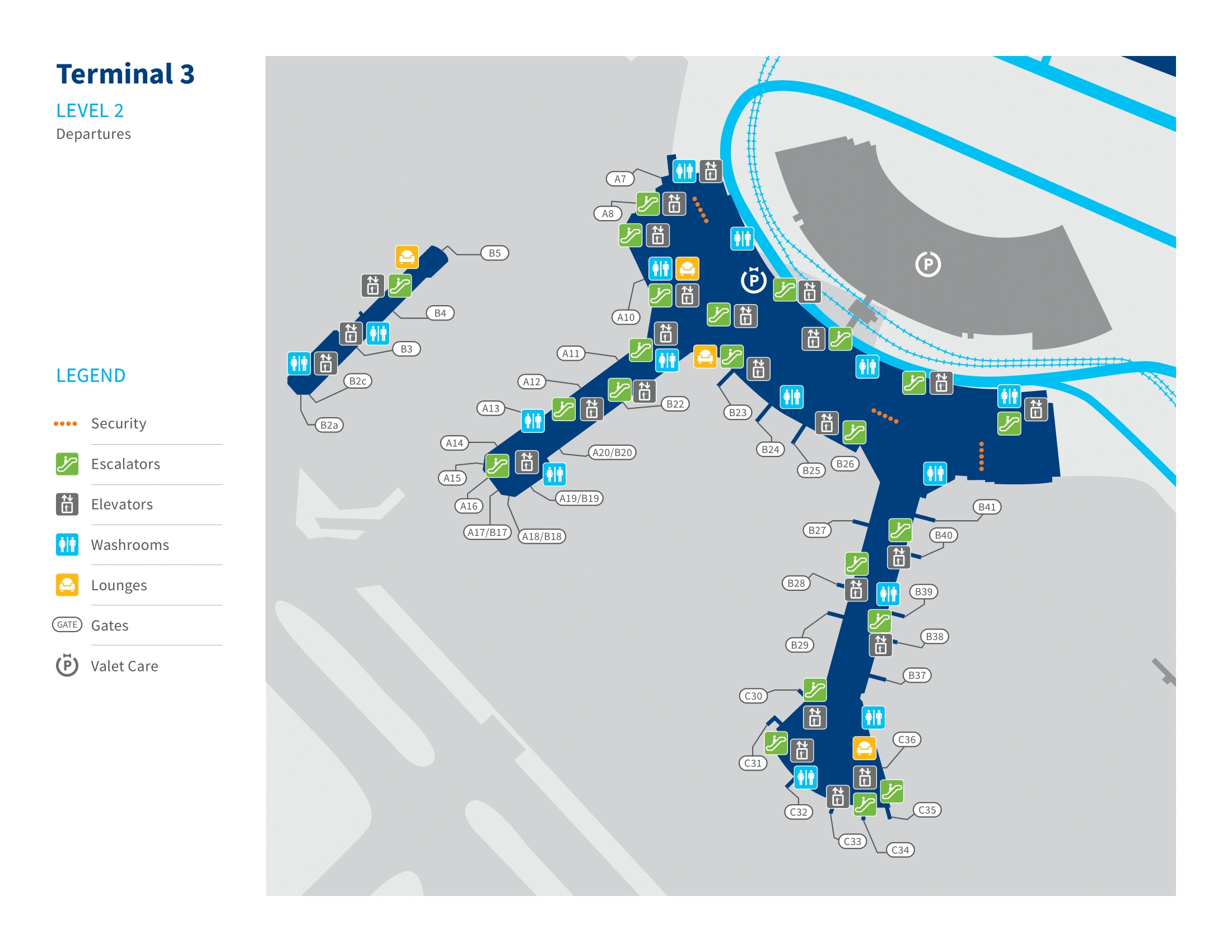
What is the exact physical location of the Terminal 3 primary security checkpoint entrance (level + nearest doors/landmarks) where the main queue begins?
Terminal 3’s main non-US security entry is the B/C (Domestic/International) checkpoint on Level 2, centered behind the main check-in hall. It sits directly behind the WestJet counter zone and the retail spine, and the queue typically starts in the atrium space immediately in front of the security façade—not at the screening podiums.
The entrance is on Level 2 (Departures), in the central hall area aligned with the WestJet check-in aisles and near the vertical core signed for the Sheraton/Level 3 connector. The main queue origin is usually where CATSA stanchions first form a serpentine line in the open floor between check-in kiosks and the checkpoint frontage. For US flights, the equivalent “primary” entrance is separate: Level 2, far west end near the American/Delta counters, signed for Gates A with a US flag icon.
What is the walking time (minutes) from Terminal 3 departures curb / main entrance doors to the start of the security queue (not the screening podium)?
Walking takes about 1.5 to 3 minutes from the Terminal 3 Departures curb doors to the start of the security queue, assuming you’re dropped at the correct door for your checkpoint. The distance is short, but the “time tax” comes from weaving through check-in congestion, not from the hallway length.
- Correct-door drop-off (example Door 4–8 for B/C) typically puts you on a straight line through the vestibule and into the central hall, with the stanchion start usually in the open atrium in front of the B/C security façade.
- West-end drop-off (Doors 1–3 for A Gates) shortens the walk to the US checkpoint because you avoid crossing the central retail spine.
- Peak banks can add seconds from crowd slalom around check-in queues, but the pure curb-to-queue-start walk still usually stays under 3 minutes.
Where is the YYZ Express (security appointment) entry point located in Terminal 3 (exact checkpoint/door/level), relative to the standard security line?
YYZ Express is a dedicated appointment lane at the Terminal 3 B/C (Domestic/International) security checkpoint on Level 2, positioned on the side of the standard general queue at the checkpoint frontage. It is not a separate checkpoint and does not relocate you to the A-gates (US) security.
The entry point is at the B/C security face on Level 2, where specialized lanes cluster (YYZ Express, NEXUS/trusted traveler, and assistance/family, depending on the day’s stanchion setup). Instead of joining the serpentine queue that fills the central atrium, you stay on the perimeter edge of the checkpoint area and look for “YYZ Express / Reservation” signage and a QR code scan/check point staffed at the lane mouth.
What is the exact route (turn-by-turn landmarks) from Terminal 3 check-in counters to the YYZ Express access point without crossing into the regular queue?
The route stays on Level 2 and works by approaching the B/C checkpoint from the outside edge, not from the center of the serpentine. Starting at the check-in counters, walk toward the B/C security façade but keep to the perimeter so you never enter the stanchioned “General” maze.
| Step | Landmark anchor | What you do |
|---|---|---|
| 1 | Level 2 check-in row (WestJet/central counters) | Face toward the B/C “Gates B & C / All gates except US” overhead signs |
| 2 | Central atrium in front of security | Walk forward but stay outside the stanchion boundary; do not pass through the opening where the general line feeds in |
| 3 | Checkpoint frontage edge | Track along the outer side of the queue toward the cluster of specialty lanes (where staff are checking eligibility) |
| 4 | YYZ Express mouth | Stop at the “YYZ Express / Reservation” sign with QR check and present your appointment code before the document check position |
Where is the US preclearance area entrance in Terminal 3, and what is the exact decision point where a traveler can accidentally go the wrong way?
The US preclearance flow starts by entering the A-gates (US Transborder) security checkpoint on Level 2 at the west end of Terminal 3, and then feeding directly into the USCBP preclearance hall immediately after CATSA screening. The highest-risk wrong turn happens earlier—when a US-bound traveler joins the central B/C security line instead of walking west to the A checkpoint.
The decision point is in the Level 2 Departures hall near the central retail spine/WestJet counter area, where overhead gantry signs split travelers: “Domestic / International (Gates B & C)” points toward the prominent central checkpoint, while “US Connections / Gates A” points west and is typically marked with a US flag icon. If you enter security without seeing “Gates A / US” on the overhead sign, you’re committing to the wrong sterile zone and will have to exit and re-screen to reach preclearance.
What is the walking time (minutes) from Terminal 3 security exit to the entrance of US preclearance for US-bound gates?
Walking takes about 0.5 to 1 minute (roughly 30–60 seconds) from the A-gates security exit to the US preclearance entrance in Terminal 3. The transition is essentially immediate because the corridor between CATSA screening and the USCBP hall is very short.
After you collect your bins and bags at the A-checkpoint exit, you continue forward through a short connector corridor (about 20–30 meters) that funnels directly into the US customs/preclearance hall. There’s no meaningful “airside buffer” for detours—this is a forced pipeline—so plan restroom/food stops before entering the A-gates security flow.
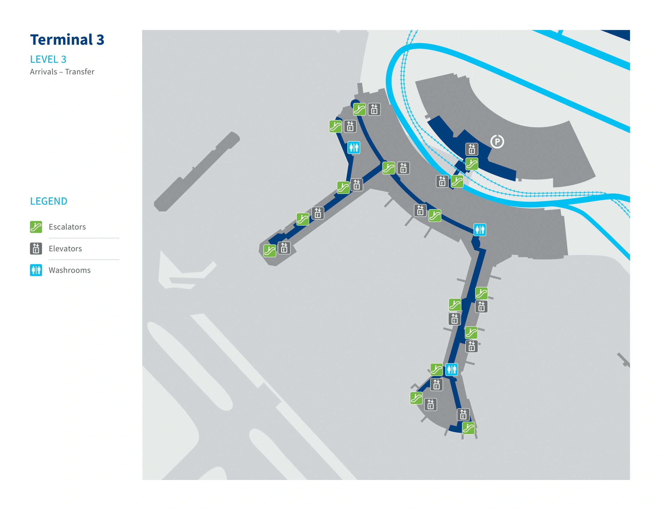
From Terminal 3 international arrivals customs exit, what is the shortest path to the Terminal Link (Link Train) platform (include which escalator/bridge/“Sheraton” sign sequence)?
The shortest path goes up to Level 3 via the Sheraton/Terminal Link vertical core, then across the enclosed Sheraton bridge to the station entrance. The train is not on Arrivals (Level 1) or Departures (Level 2), so the key is committing quickly to the “Sheraton / Terminal Link” signs and climbing.
From the CBSA customs exit on Level 1, walk into the public Arrivals hall and aim for the central axis where overhead wayfinding points to “Sheraton” and “Terminal Link.” Take the escalator or elevator up to Level 3 (mezzanine/hotel link). On Level 3, follow the enclosed pedestrian bridge toward the Sheraton Gateway Hotel; the hotel lobby entry appears adjacent on the right, and the Terminal Link station entry is immediately beside that connection point. If you’re still on Level 1 curbside doors, you’ve missed the vertical pivot.
What is the maximum expected wait interval between trains at the Terminal Link platform during normal operations (as posted at the platform), and where is the posted sign located?
The maximum expected wait during normal operations is 8 minutes, with peak service typically around 4 minutes. The posted interval appears on the digital countdown displays that show “Next Train: X min.”
The sign is located on Level 3 at the Terminal Link station: one set of screens is mounted above/near the platform doors where trains arrive, and another is placed at the station entry from the Sheraton pedestrian bridge (the point where you step off the bridge into the station area). Use the countdown at the bridge entry to decide whether to hustle or settle in, since an off-peak “just missed it” effectively adds the full interval before you even board.
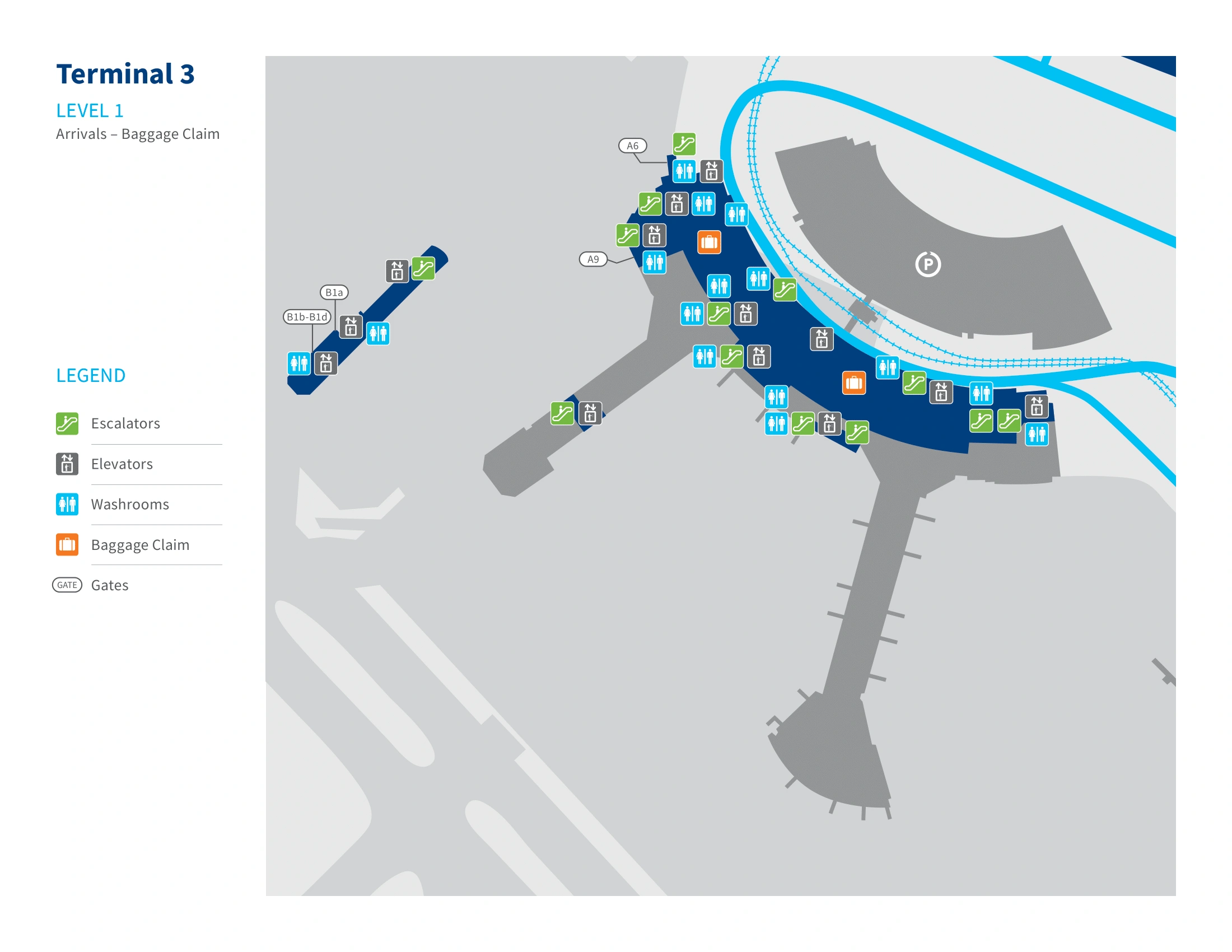
From Terminal 3 arrivals baggage claim hall, what is the exact walking distance to the rideshare pickup zone used by app pickups (doors/columns/zones)?
Walking distance is about 120 meters (around 400 feet) from the baggage claim hall to the app-based rideshare pickup area at Terminal 3’s Outer Curb. The endpoint is Zone 3 at the median island, typically aligned with pillars in the C24–C30 range.
From the baggage claim hall on Level 1, head for Door D (the most direct exit for ground transport), step to the Inner Curb area, then use the designated crosswalk to cross the active taxi lane to the Outer Curb median island. Once on the island, orient to Zone 3 and match your pickup code to the nearest pillar marker (for example, C27) so the driver can stop in the geofenced loading band without circling.
Where exactly is “C27” in the Terminal 3 pickup system (what level/curb/zone), and what is the nearest door/column marker a traveler should physically stand at?
C27 is a numbered curbside pillar on Level 1 at Terminal 3’s Outer Curb rideshare island, within the Zone 3 ride-app pickup area. It refers to the physical column you stand beside so your driver can match the app’s pickup point to the correct loading position.
The most direct approach is exiting baggage claim through Door D on Level 1, crossing from the Inner Curb to the median (Outer Curb) via the marked crosswalk, then walking along the island to the pillar labeled C27. If your app shows a nearby range (often C24–C30), stand directly at the printed “C27” marker on the column face rather than between pillars—drivers use those pillar numbers as their primary visual lock-on in the geofenced zone.
What is the most direct pedestrian route from Terminal 3 baggage claim exit to the taxi/limousine stand (exact door/curb side)?
The most direct route is exiting Level 1 baggage claim through Door D and turning immediately to the Inner Curb taxi stand without crossing to the median. Taxi and limousine pickup at Terminal 3 is designed to be accessed curbside on the inner lane, so the “shortest path” is the Door D → Inner Curb vector.
| Step | Landmark anchor | Direction |
|---|---|---|
| 1 | Level 1 baggage claim hall | Walk toward the ground transportation exits, targeting Door D signage |
| 2 | Door D sliding doors | Exit to the curb frontage; you are now at the Inner Curb side |
| 3 | Inner Curb loading lane | Turn along the curb (no crosswalk) to the taxi stand queue line |
| 4 | Limousine pickup | Stay on the Inner Curb; limos typically stage nearby (often closer to Door C), not on the Outer Curb island |
In Terminal 3, where is the baggage claim carousel exit point that leads most directly to ground transportation without detouring through other halls?
The most direct exit node from baggage claim to ground transportation is Door D on Level 1. It aligns cleanly with the Inner Curb taxi stand and the crosswalk to the Outer Curb rideshare island, so it avoids the long curbside walks you trigger by exiting far west or far east.
From inside the baggage claim area, the “best” carousel-side exit choice is the one that funnels you toward the central ground transportation doors rather than toward the terminal ends. Aim for the exit stream signed for Door D/ground transport, then commit to Door D as your physical leave-point: taxis are immediately curbside on the Inner Curb, and ride-app pickups require the quick crosswalk hop to the median island (Zone 3 pillars).
What is the walking time (minutes) from Terminal 3 domestic baggage claim to the outer curb pickup doors used for passenger pickup/rideshare?
Walking takes about 2 to 3 minutes from Terminal 3 domestic baggage claim to the Outer Curb rideshare/pickup island if you exit via Door D. The terminal is narrow at this point, so most of the time is spent on the curbside crossing and aligning to the correct zone/pillar.
From the carousel area on Level 1, you’re usually under a minute to Door D, then about another minute to cross from the Inner Curb to the median via the marked crosswalk and reach the Outer Curb loading strip. Add extra time if you’re waiting for a walk signal, pulling a heavy bag, or needing to walk along the island to a specific pillar number (for example, C27).
What is the walking time (minutes) from D gates to E gates post-security in the Terminal 3-connected area (measured on the official map path)?
There are no D or E gates in Terminal 3; D and E gates are in Terminal 1, and there is no post-security pedestrian connection between Terminal 3 and Terminal 1. Any D→E “post-security” walk cannot happen inside Terminal 3 and would require a landside exit, the Terminal Link train, and re-clearing security.
Within Terminal 3’s actual post-security layout, the closest equivalent is a B↔C concourse walk in the Domestic/International sterile zone. A typical reference segment is about 6 to 9 minutes from the central B-gate hub area (around mid-B gates) to the far end of the C pier (end gates), following the continuous airside corridor with moving walkways. If your boarding pass says Gate D or E while you’re in Terminal 3, treat it as a terminal error and transfer to Terminal 1 landside.
Where is the one-way corridor boundary between the D and E gate areas (the point you can’t return past without passport control), and what signage marks it?
There is no D↔E one-way boundary in Terminal 3 because D and E gates are in Terminal 1, not Terminal 3. In Terminal 3, the true “no-return” boundary that behaves like a one-way corridor is the US Transborder (A gates) preclearance threshold: once you enter the US-controlled processing flow, you effectively cannot reverse back into the main terminal without intervention.
The practical boundary is at the entrance into the USCBP preclearance hall after the A-gates security screening, where the flow becomes controlled and directional. Signage that marks the point typically includes “Customs Controlled Area,” “No Re-Entry,” and restricted/exit-only door markings near the sterile dividers that separate the US A-gates system from the Domestic/International B/C system. If you need B/C gates after entering the A-gates flow (or vice versa), the correction requires returning landside and re-screening rather than backtracking airside.
For a Terminal 1 → Terminal 3 transfer, where is the exact entry point to Terminal 3 security after exiting the Link Train (which level/doors), minimizing backtracking?
The fastest entry is to exit the Link Train at the Terminal 3 station on Level 3 (Sheraton bridge level), cross into the terminal via the enclosed Sheraton pedestrian bridge, then go down one level to Level 2 Departures for security. This avoids the common mistake of dropping to Level 1 Arrivals and having to climb back up.
After you descend to Level 2, you’re in the main check-in/departures processing hall: turn left/central for the B/C (Domestic/International) security checkpoint behind the main check-in zone, or turn right/west for the separate A-gates (US) checkpoint near the American/Delta counter area. The “minimize backtracking” rule is simple—stay on Level 3 only long enough to enter the building, then go directly to Level 2 for the correct security split, without detouring to curbside on Level 1.