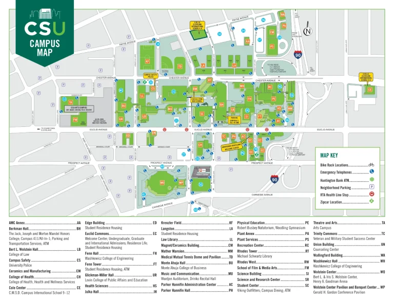
Kansas City International Airport Map (Most Up-To-Date)
Kansas City International Airport now operates as a single, consolidated “I-shape” terminal: a central headhouse (check-in, TSA, baggage claim) feeding two long concourses (A and B) with a post-security connector. The building is large (1M+ sq ft) with strict one-way ground loops: Departures on the upper level (Level 2) and Arrivals on the lower level (Level 1). Most ground-side confusion happens along Cookingham Drive within Kansas City’s main airport grounds.
Map Table
| Terminal | Key Airlines | Primary Function | Transfer Mode |
|---|---|---|---|
| Headhouse (single terminal core) | Southwest, American, Delta, United | check-in, single TSA, baggage claim, ground transport | indoor walking, bridges to garage |
| Concourse A | United, Delta, Spirit, Alaska, American (some) | gates A1–A20 zone | walking from TSA node |
| Concourse B | Southwest (dominant) | gates B40–B69 zone, City Market node | 635-ft connector, moving walkways |
Kansas City International Airport Map Strategy
- Treat the Arrivals curb as active loading only: stage in the Cell Phone Lot until the passenger texts a specific pillar/column (example: “2K”), because no-wait enforcement and curb bottlenecks make “just circling” a time penalty.
- From the Cookingham Drive inbound approach, commit early to the correct level: stay left for Arrivals (Lower Level) and avoid the right lanes that force Departures (Upper Level) with no mid-stream crossover and a Bern Street recirculation loop.
- Use the curb’s alphanumeric pillar/column system as your meet-up precision tool: 1A–1D aligns better with lower-number baggage claim areas; 2H–2N aligns better with higher-number carousel areas and the rideshare cluster (2K–2N).
- Budget walks like a terminal, not a curbfront: Concourse B far gates (B60s/B69) require the 635-ft connector plus additional concourse distance—plan your time and food runs around the City Market hub near mid-Concourse B, not the gate endcaps.
2026 Kansas City International Airport Map + Printable PDF
This single-terminal layout remains the operative footprint for 2026, with centralized TSA, split-level curbs (Arrivals below, Departures above), and rigid one-way roadway flows that punish wrong-lane choices. The most “print-worthy” parts of the map are the Cookingham Drive vertical split, the pillar/column system on the Arrivals curb (1A–2N), and the commercial curb zones (rideshare 2K–2N, rental car shuttle at the center median).

Printable Kansas City International Airport Terminal Map PDF 2025
2026 Kansas City International Airport Map Guide
What is the exact driving route (with decision points) from the Cell Phone Lot to the Arrivals pickup curb at Kansas City International Airport?
Merging left for Arrivals (Lower Level) at the Cookingham Drive vertical split is the dealbreaker, because staying right forces Departures (Upper Level) with no crossover and triggers a Bern Street recirculation loop.
Start at the Cell Phone Waiting Lot (680 Brasilia Avenue), exit to Brasilia Avenue, then make the Bern Street turn to cross the bridge and enter Cookingham Drive inbound. As the terminal comes into view, commit to the left lanes signed “Arrivals / Lower Level,” then follow the lower-level frontage to the Arrivals curb and stay in the inner lanes for private pickups. Use the curb pillar/column system (1A–2N) as your final decision cue for where to stop.
What is the exact walking distance (feet/meters) from the Arrivals curb pickup doors to the nearest baggage claim carousel zone?
Walking takes approximately 50–80 feet (15–25 meters) from the Arrivals curb pickup doors to the nearest baggage claim carousel edge.
The shortest path starts at the Arrivals (Level 1) automatic doors directly off the inner (private vehicle) curb. Once inside, the closest baggage carousel zone is immediately ahead in the shallow Arrivals hall; the distance is small, but the choke point is people density near the carousel faces and door vestibules. For the fastest crossing, aim for the nearest open aisle between waiting groups rather than walking along the carousel perimeter.
Which parking garage elevator/stair core delivers the shortest indoor route to the main TSA/security entrance, and what is that walking distance?
The South elevator core or the Central elevator core delivers the shortest indoor route to the main TSA entrance, at approximately 300–400 feet (90–120 meters).
The shortest setup starts by parking on Garage Level 2 (Departures level alignment), then walking to the terminal-side elevator lobby at the South or Central core and using the Level 2 pedestrian bridge into the check-in hall. From the bridge entry, walk straight toward the center of the headhouse where the single consolidated TSA checkpoint sits. This route stays indoors and avoids the Level 1 roadway crossing that can add delay at busy curb periods.
Where is the rideshare (Uber/Lyft) pickup zone relative to baggage claim, and what is the shortest signed walking route between them?
Rideshare pickup is on the Arrivals commercial curb at the far end of the frontage, signed with purple markers at columns 2K through 2N.
The shortest signed route starts at baggage claim and works best from the higher-number end of the hall: walk toward carousels 7–9, exit through the nearest Arrivals doors, then use the marked crosswalks to cross the private-vehicle lanes to the commercial median. Once on the commercial side, turn right and follow the sidewalk/median signage until the purple rideshare pylons and column labels 2K–2N come into view.
From the main TSA exit point, what is the walking distance to the farthest gate cluster in the terminal?
No intra-terminal train or shuttle exists, so reaching the farthest gates is walking-only from the main TSA exit. Walking takes about 1,500–1,600 feet (450–490 meters) from TSA to the far end of Concourse B, with Gate B69 as the typical farthest target.
| Segment | Landmark anchor | Distance |
|---|---|---|
| TSA exit to connector entrance | Concourse A post-security node | ~50 ft |
| Connector tunnel | moving walkways between A and B | 635 ft (193 m) |
| Concourse B hub to far gates | City Market area near Gate B52 to Gate B69 | ~850–900 ft (260–275 m) |
| Total | TSA to Gate B69 | ~1,550 ft (~470 m) |
Where is the rental car shuttle pickup point located (level/door/core), and what is the shortest indoor path from baggage claim to that pickup point?
Rental car shuttle pickup is on Arrivals Level 1 at the commercial curb center median, signed for the gray “Rental Car Shuttle” buses.
The shortest indoor path starts at the middle of the baggage claim hall near carousels 4–5. Exit through the central Arrivals doors closest to those carousels, then use the nearest marked crosswalk to reach the center pedestrian island/median that separates private pickup lanes from the commercial curb. Follow the overhead gray “Rental Car Shuttle” signs on the median to the sheltered stop area, staying on the commercial side rather than the inner private-vehicle curb.
What is the shortest walking route from the Arrivals pickup curb to short-term parking (for drivers who choose to park-and-wait), including which entry point/core to use?
Walking uses the marked crosswalks from the Arrivals curb to the main parking garage, entering at the Level 1 garage lobby and then using the North or South elevator core to reach your parked level.
From the Arrivals (Level 1) inner curb, head to the nearest signed pedestrian crosswalk aligned with your curb pillar/column area (1A–2N). Cross all roadway lanes only at that crosswalk to the garage face, then enter through the Level 1 garage doors into the lobby. If you need to go up, take the elevator in the nearest end core (North or South) rather than walking the garage perimeter; if you parked on Level 1, stay on Level 1 and exit the same lobby route back to the curb.
Where are the primary food courts / main concessions nodes located, and what is the walking distance from the farthest gates to the nearest concessions node?
The primary concessions nodes are the City Market Food Hall in Concourse B (at the concourse hub where the connector arrives) and the Made of Kansas City Hall in Concourse A (near gates A1–A10).
| Concessions node | Location anchor | Primary coverage | Farthest-gate walk to nearest node |
|---|---|---|---|
| City Market Food Hall | Concourse B hub near Gate B52 | Concourse B (Southwest-heavy) | Gate B69 → City Market: ~850–900 ft (~260–275 m) |
| Made of Kansas City Hall | Concourse A south near Gates A1–A10 | Concourse A | varies by A-gate position; closest for A1–A10 block |
What is the first major wayfinding decision point after exiting baggage claim (e.g., split toward pickup vs rideshare vs garage), and where is it located on the terminal path?
The first major decision point is the Arrivals egress doors where you must choose between staying at the inner curb for private pickup or crossing to the commercial curb and garage.
This split occurs immediately after you pass through the automatic doors from the baggage claim hall to the curb frontage. Straight ahead aligns with the inner lanes used for private vehicles and the pillar/column markers (1A–2N). The alternative choice is the marked crosswalks, which take you across the private lanes to the center median and the commercial curb (rideshare, shuttles) and onward toward the parking garage beyond.
What is the shortest indoor route from Departures curb drop-off to the main TSA queue entrance, including which doors to use?
Walking takes about 150–200 feet from the Departures curb drop-off to the TSA queue entrance using the central vestibule doors.
Enter from the Departures (Level 2) curb through the central set of sliding doors aligned with the main “Check-in” signage (best all-purpose entry, including for Southwest’s counter area). Once inside the check-in hall, continue straight across the open floor toward the building’s centerline; the single consolidated TSA checkpoint sits centrally at the back of the headhouse. Staying central reduces lateral wandering along airline counters and puts you on the most direct line to the queue entrance.
From short-term parking payment/exit, what is the exact driving path back to the Arrivals pickup curb without re-entering the wrong loop?
No curbside U-turn is possible, so the dealbreaker route is the Bern Street recirculation loop back to the Cookingham Drive inbound approach, then a left-lane commitment for Arrivals (Lower Level).
Exit the short-term parking/garage area and follow outbound signs that feed you onto Cookingham Drive away from the terminal. Take the Bern Street exit, turn left at the top to cross the bridge over the highway, then turn left again onto the Cookingham Drive inbound ramp toward the terminal. On approach, select the left lanes signed “Arrivals / Lower Level” at the vertical split and continue to the inner private-vehicle curb for pickup.
Where is the best “meet point” landmark (single fixed location) between baggage claim and ground transportation exits, and what is its exact map position?
The USO Lounge near Baggage Claim Carousel 5 on Arrivals Level 1 is the best fixed meet point.
This landmark sits inside the Arrivals/baggage claim hall near the midline of the carousel run, making it reachable from either end without committing to a specific exterior pillar first. It is outside security, clearly signed, climate-controlled, and distinct compared with the repeating carousel/door pattern. If you must meet outside instead, use a specific curb pillar/column (example: “Pillar 1G”) rather than “outside baggage claim.”