Kahului International Airport Map (Most Up-To-Date)
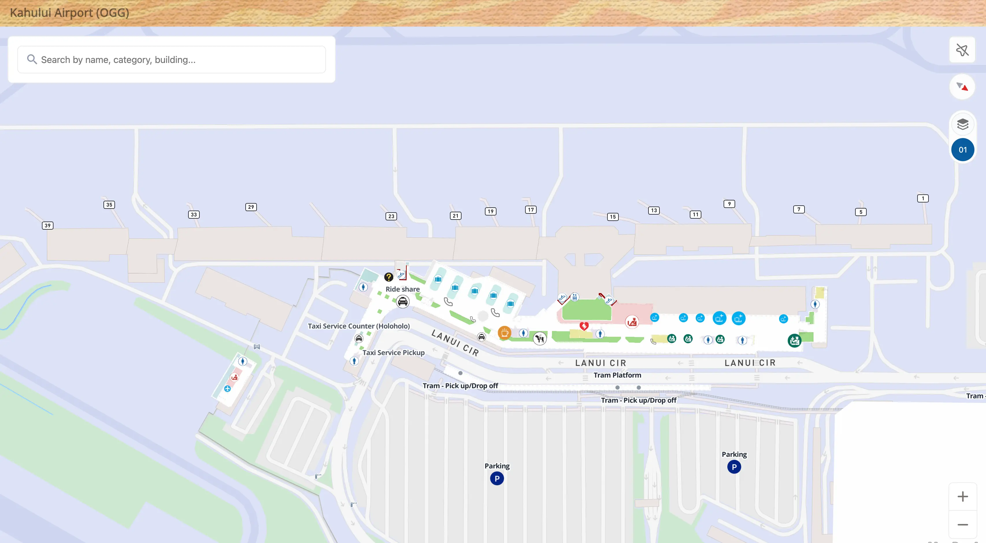
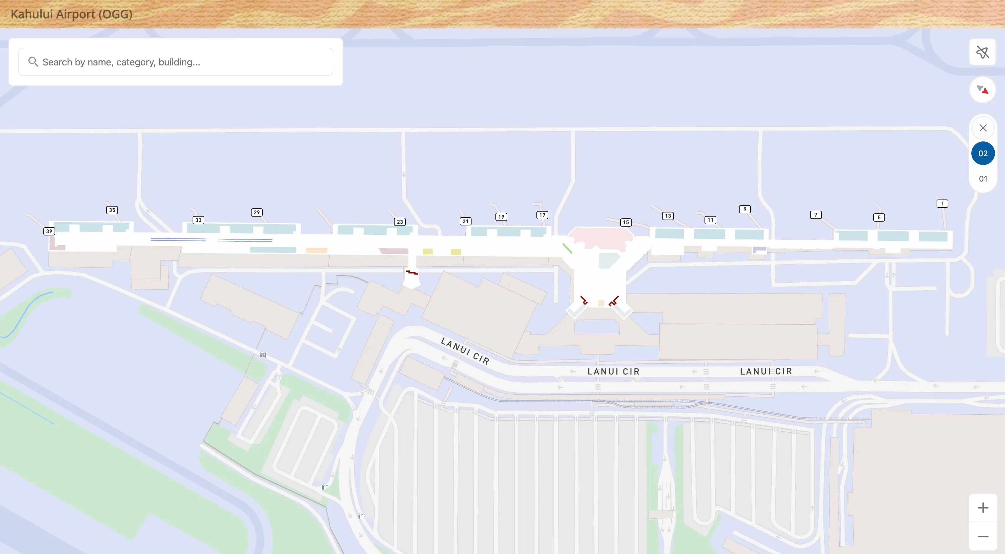
Kahului International Airport is a compact, mostly linear terminal complex arranged on a north–south axis, with departures curbside feeding directly into an open-air ticketing lobby that funnels into TSA and then splits to the South Concourse (Gates 1–16) and North Concourse (Gates 17–39). Ground transport sits “off to the side” within Maui’s main airport hub, with the consolidated rental car center set apart from the terminal by a tram and a marked walking route.
Map Table
| Terminal | Key Airlines | Primary Function | Transfer Mode |
|---|---|---|---|
| Main Terminal | Hawaiian, Alaska, Delta, United, American | check-in, USDA bag screening, TSA, baggage claim, gates | rental car tram, “Yellow Brick Road” walk, taxis, rideshare |
| South Concourse (Gates 1–16) | mainland wide-bodies, major departures | enclosed holdrooms, strongest A/C comfort zone | walk from central hub |
| North Concourse (Gates 17–39) | inter-island + mixed departures | open-air corridors, heat/humidity exposure | walk from central hub |
| Commuter Terminal | Mokulele | small-prop operations, separate flow | short walk landside |
Kahului International Airport Map Strategy
- Expect the real choke points to be bag drop and TSA, not walking distance; use the map to choose your check-in door based on your airline’s counter bank and the shortest line-of-sight path to security.
- Treat heat as a routing constraint: if the security line “snakes” toward curbside, use the map to identify indoor-adjacent queue starts and the nearest pre-TSA restroom before committing.
- Plan ground transport as a fork: use the map to compare the tram station vs the “Yellow Brick Road” walking start so you can switch instantly if the tram queue spills beyond the shelter.
- After TSA, use the map to move immediately to the closest air-conditioned seating/restroom cluster (central hub or South Concourse) before heading to far North Concourse gates.
2026 Kahului International Airport Map + Printable PDF
South Concourse comfort and circulation stay materially different from the legacy open-air north side at 2026, so a printable Kahului map is most useful when it highlights where A/C starts and ends, plus the reworked security split (main checkpoint vs overflow). Use the map to pre-pick doors for check-in, TSA, and ground transport so you’re not improvising in heat or crowds.
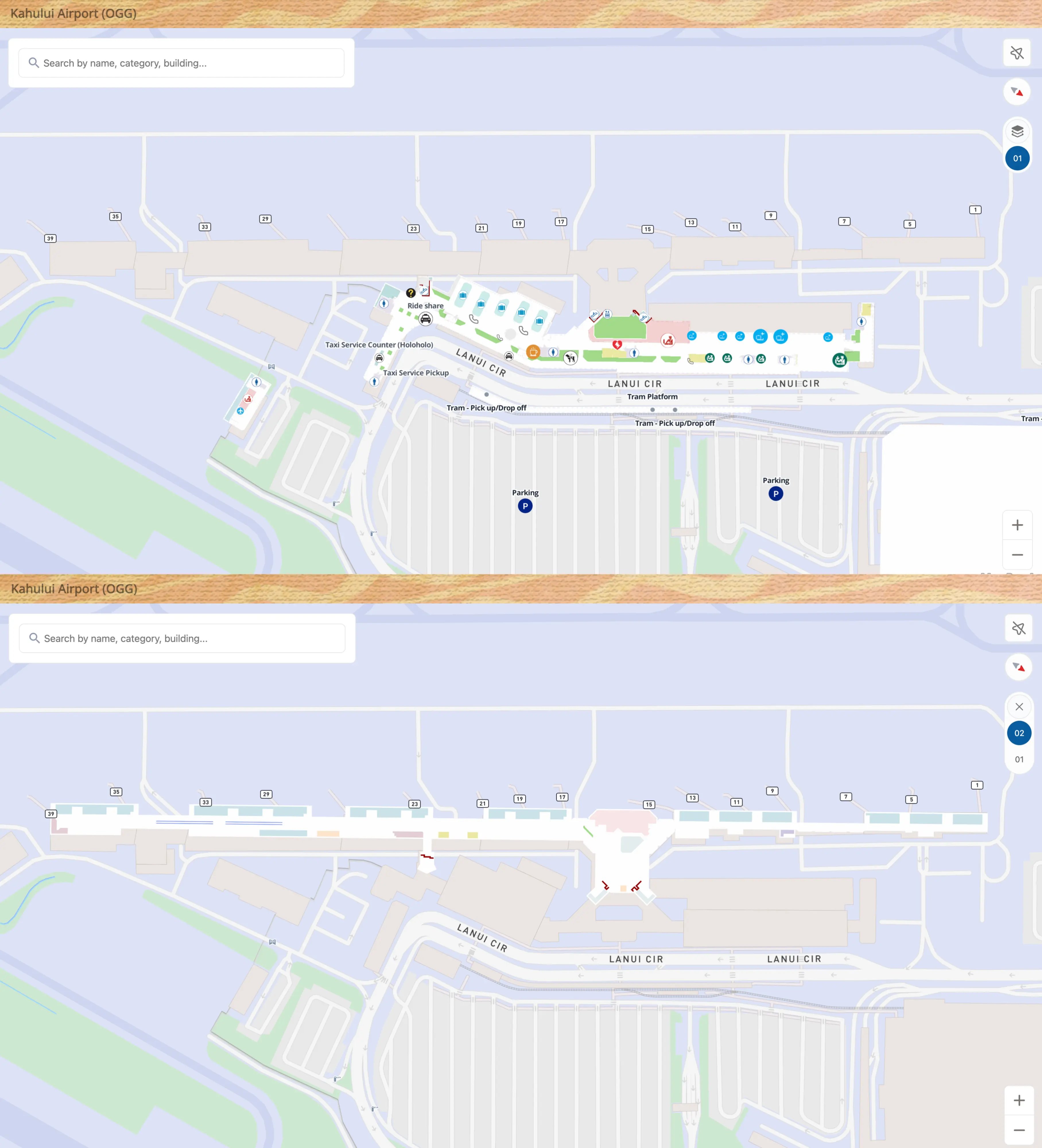
Kahului International Airport Level 1 Map 2026
Kahului International Airport Level 2 Map 2026
2026 Kahului International Airport Map Guide
Where does the TSA queue physically begin during peak periods at OGG (exact landmark/door), and what path does it wrap along on the departures-level map?
The TSA line at the main security checkpoint begins at the central ticketing lobby stanchions near the primary checkpoint entrance, then expands into the “Snake” that can spill past the formal queue footprint and out toward the departures-side sidewalk when volume peaks. During overflow, the wrap typically runs back through the open-air check-in hall in front of the airline counter banks, then continues along the curbside-facing edge of the lobby where heat exposure is highest.
| Peak-state line shape | Where it starts | How it wraps | What it’s adjacent to |
|---|---|---|---|
| Normal (contained) | stanchion mouth at main checkpoint | back-and-forth inside ropes | central ticketing lobby, airline counters |
| Overflow (“Snake”) | same checkpoint mouth | out of stanchions → down the lobby length | curbside sidewalk edge, counter fronts, USDA area |
| Severe spill | checkpoint mouth + overflow tail outside | exterior sidewalk segment | departures curb, drop-off roadway |
Which exact entrance/door is the primary access point to the TSA checkpoint from the airline check-in hall (map-verified)?
The primary access point is the main security checkpoint entrance in the central ticketing lobby, reached by walking straight inward from the central airline counter banks to the TSA stanchion mouth at Checkpoint 1. This is the most direct “check-in hall → TSA” path for both general screening and the consolidated PreCheck flow, and it’s also where the overflow “Snake” forms when volume pushes the line beyond the ropes.
From a navigation standpoint, treat Checkpoint 1 as the default door/threshold: face the ticketing counters, then orient toward the interior-center opening where the TSA queue begins. If general screening lines are visibly spilling toward curbside, the practical move is to use that same central access point as your visual reference while you quickly scout the overflow checkpoint farther south before committing to the long exterior-facing wrap.
What is the exact walking distance (feet/meters + minutes) from the Consolidated Rental Car Facility pedestrian exit to the terminal departures entrance?
The walking route is about 0.5 miles (roughly 2,640 feet / 800 meters) and typically takes 8–12 minutes from the consolidated rental car facility’s pedestrian exit to the terminal departures entrance. The path follows the marked “Yellow Brick Road” route, running generally parallel to the tram guideway and roadway buffers.
The only true pause point is the signalized crossing at the Aalele Street and Keolani Place intersection, where the walk can briefly slow if you hit a red light. Once across, you continue southwest-to-northeast toward the terminal frontage, aiming for the departures-side check-in lobby doors rather than the arrivals curb. If you see the tram queue extending beyond the shelter roof, this walk is the faster, more predictable option for able-bodied travelers with rolling luggage.
Where is the rental car tram/trolley boarding point located inside the rental car facility (map position relative to the rental counters)?
The consolidated rental car facility tram stop is located on the upper level adjacent to the main rental counter zone, where the platform opens directly into the customer-facing counter lobby. The boarding area sits at the edge of the counters’ floorplate, so you move from the platform into the counters in one continuous flow rather than navigating deep into parking levels.
Operationally, treat the counters as your anchor: once you reach the rental counter lobby, follow the “Tram/Terminal” wayfinding back toward the same upper-level edge where the trains arrive and depart. If you find yourself among vehicle stalls or on the ground-level pedestrian entrance, you’re one level below the counter hall and need to go up (elevator/escalator) to reach the tram boarding point.
From baggage claim, which exit door is geographically closest to the rental car facility connection (tram/walkway) on the terminal map?
The closest exit is the baggage-claim-side opening that leads directly toward the crosswalk for the tram station and the start of the rental car connection corridor, generally from the central-to-south portion of the baggage claim sidewalk. This puts you on the shortest line to the median tram shelter and also keeps you near the “Yellow Brick Road” walking start if the tram line is a dealbreaker.
On the map, use the tram station as the fixed landmark: exit baggage claim at the opening that faces the median station across the inner pickup roadway, then take the marked crosswalk rather than walking the full length of the curb. If you exit too far north/east (toward the commuter terminal direction), you’ll add backtracking before you can line up with the tram/walk connection.
What is the exact mapped route from baggage claim to the designated rideshare pickup zone (follow signage nodes/doors)?
The rideshare pickup route runs from the baggage claim exits to the “Ride App / TNC” median zone positioned between the baggage claim frontage and the commuter terminal. You leave the baggage claim hall, orient toward the commuter terminal side (north/east), then follow “Ride App” signage to the inner roadway crossing that delivers you onto the designated median strip rather than the main curb.
The practical node-to-node sequence is: exit baggage claim to the sidewalk → turn right toward the commuter terminal direction → follow posted “Ride App” wayfinding → cross the inner roadway to the median pickup island and wait inside the marked TNC area. Because drivers are typically staged off-site and geofenced, request your ride as you approach the exit so your arrival at the median aligns with the driver’s release toward the pickup zone.
After clearing TSA, where is the nearest air-conditioned indoor seating area (map location on concourse/holdroom layout)?
The nearest reliable air-conditioned seating is in the central post-security hub, immediately beyond the TSA exit where the main food and retail cluster begins, with additional strong A/C seating in the enclosed South Concourse (Gates 1–16). This “Cool Zone” starts close to the security outflow and stays noticeably more comfortable than the open-air North Concourse.
If you need seats fast, clear TSA and then take the first available seating pockets in the central hub near the primary concessions before walking deeper toward your gate. For the highest odds of sustained A/C, continue a short distance into the South Concourse holdrooms and wait there, then only walk to the North Concourse gates later if your departure is from Gates 17–39 and outdoor heat is high.
Where is the closest restroom to the TSA checkpoint entrance (map location + walking distance from the checkpoint threshold)?
The closest pre-security restrooms are at the ends of the ticketing lobby, reached by walking along the departures-level check-in hall from the TSA checkpoint entrance. These are the “use-before-you-queue” restrooms that keep you from abandoning your place if the TSA line becomes the Snake.
| Restroom option | Map position anchor | Approx. walk from TSA entrance | Best use case |
|---|---|---|---|
| Pre-TSA ticketing lobby restroom | end-cap of ticketing lobby | ~200–400 ft (60–120 m), ~1–3 min | before joining a long TSA line |
| Post-TSA central hub restroom | immediately after security exit into central hub | ~150–300 ft (45–90 m) past screening | right after clearing TSA |
Where are the airline check-in / bag-drop counter rows positioned relative to the TSA checkpoint entrance (map-verified orientation and nearest counter bank)?
The airline check-in and bag-drop counter rows run along the curb-facing edge of the ticketing lobby, with the TSA checkpoint entrance set inward toward the central interior of that same departures-level hall. Standing at the counters and facing the building, TSA is “behind you and slightly inward,” reached by walking straight off the counter line into the middle of the lobby toward the stanchions.
Carrier positioning follows a north–south spread: major mainland carriers sit across the central/south counter banks, while Hawaiian Airlines holds a larger footprint toward the south end of the ticketing hall, and smaller inter-island/commuter activity concentrates farther north near the commuter-terminal side. In peak periods, the USDA bag-screening stations positioned in front of the counters create a second queue layer that can push foot traffic into the same central lanes you need to reach TSA.
Where is the agricultural screening point located for departures (map pin + the single required walking path to reach it)?
The USDA agricultural screening stations are in the departures ticketing lobby directly in front of the airline check-in and bag-drop counters, functioning as the mandatory first step for checked bags bound for the U.S. Mainland. The required walking path is curbside → enter the departures-level check-in hall → join any open USDA X-ray/tag station line → receive the clearance sticker/tag → walk straight to your airline’s bag-drop queue behind that station.
Operationally, the “map pin” is the row of standalone USDA X-ray machines placed between the public walking lane and the counter fronts. If the station in front of your airline is jammed, the workable move is lateral: use a nearby USDA station with a shorter line (even if it’s in front of another carrier), then return to your airline’s counter bank with the tagged bag for acceptance.
Which curbside lanes/curb segments correspond to passenger pickup vs drop-off, and where are the merge/conflict points on the terminal roadway layout?
Departures curbside on the upper level functions primarily as drop-off, while arrivals curbside on the ground level functions primarily as pickup, taxi, and shuttle loading. The worst conflict happens where vehicles leaving the terminal frontage try to merge from the “return to terminal” loop into the main “exit to Kahului” flow, backing congestion toward the curb.
| Curbside segment | Level | Primary use | Typical conflict point |
|---|---|---|---|
| Departures curb outside check-in lobby | upper | passenger drop-off, quick unload | pedestrians crossing lobby edge during queue spill |
| Arrivals curb outside baggage claim | ground | private pickup, taxis, shuttles | double-parking + shuttle stops choking the inner lane |
| Inner roadway crossings near baggage claim | ground | pedestrian movement to median zones | vehicle–pedestrian friction at crosswalks |
| Loop merge from terminal return lanes to outbound exit | roadway loop | clearing the frontage | main merge point where backups stack toward terminal |