Hollywood Burbank Airport Map (Most Up-To-Date)
Hollywood Burbank Airport is a compact, curb-tight airport with two small terminals facing a single landside loop road and a short-term parking structure directly opposite the terminal frontage. The layout is essentially a short, straight terminal line with ground-transport “islands” in the middle, so orientation is simple—but within Burbank’s main airport grounds, the wrong curb choice at peak times can still cost real minutes, especially for bag drop, parking, and rideshare pickup.
Map Table
| Terminal | Key Airlines | Primary Function | Transfer Mode |
|---|---|---|---|
| Terminal A | Southwest | Main ticketing hall, primary TSA, Gates A1–A9 | Walk, curb islands |
| Terminal B | Alaska, American, United | Secondary ticketing, smaller TSA, Gates B1–B5 | Walk, curb islands |
Hollywood Burbank Airport Map Strategy
- Treat BUR as “small but node-sensitive”: the wrong curb island, wrong pickup spot, or wrong parking exit can add real minutes even when the terminal looks steps away.
- For rideshare, stand on the correct ground-transport island before you request the car; a full pickup zone can force a driver to loop and turn an easy pickup into an 8–12 minute delay.
- Build a separate buffer for checked bags—especially Southwest—because bag-drop lines can outgrow the stanchions and become the true choke point even when TSA is moving.
- If you park remote/economy, budget hidden time for the full chain (park → wait → shuttle → island drop-off → crosswalk), and confirm the exact island/stop so you don’t waste a shuttle cycle standing at the wrong curb.
2026 Hollywood Burbank Airport Map + Printable PDF
Active construction tied to the Elevate BUR replacement terminal continues to reshape how you access parking and curbside pickup. Lot A’s closure concentrates traffic into remaining lots and the short-term structure, while rideshare capacity remains constrained at the ground-transport islands. For printing, a 2026 map is most useful when it clearly labels the islands, shuttle stops, and the shortest crosswalks between parking and the terminals.
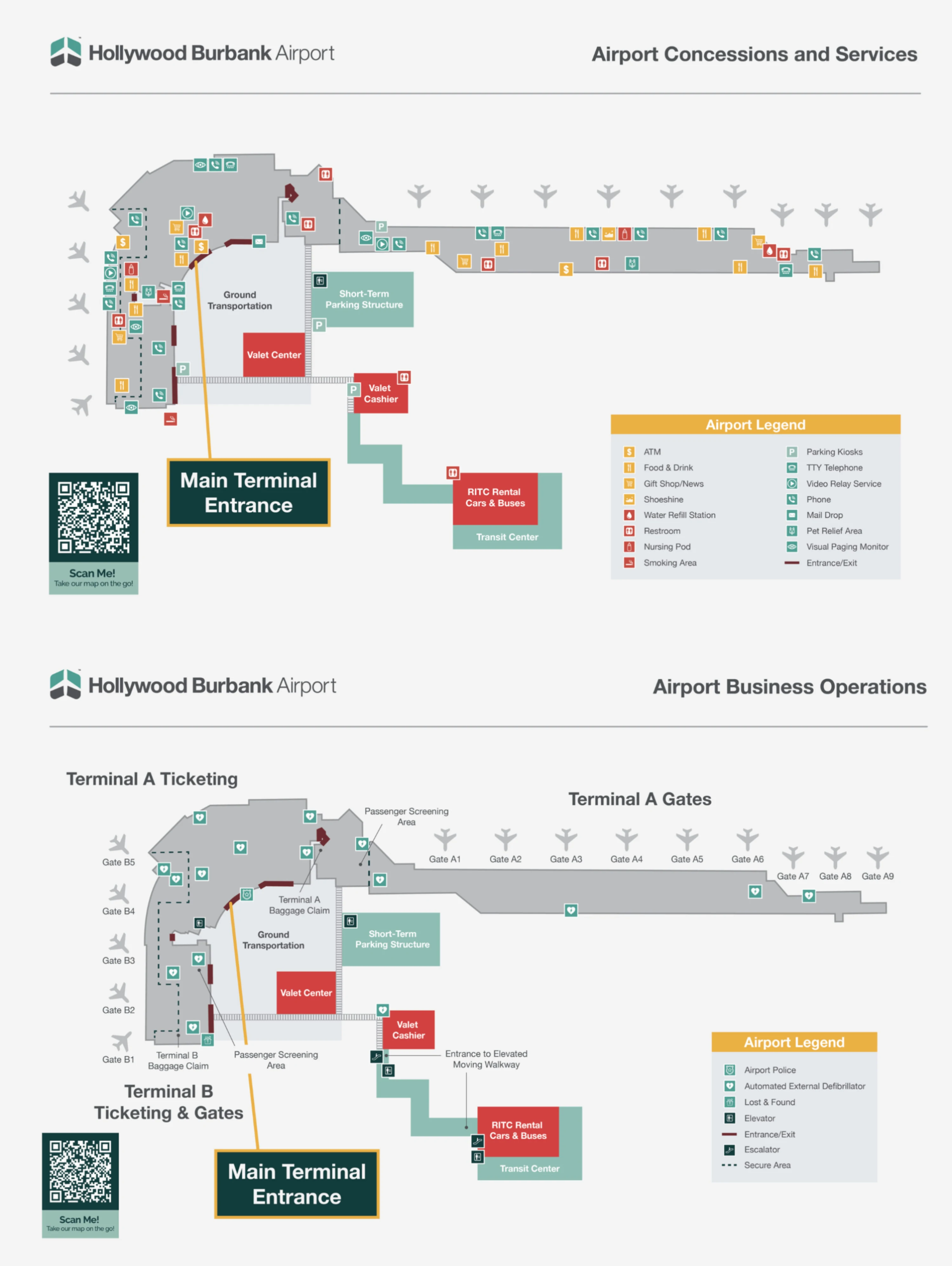
Hollywood Burbank Airport Terminal A B Map 2026
Hollywood Burbank Airport Concessions and Services Map 2026
2026 Hollywood Burbank Airport Map Guide
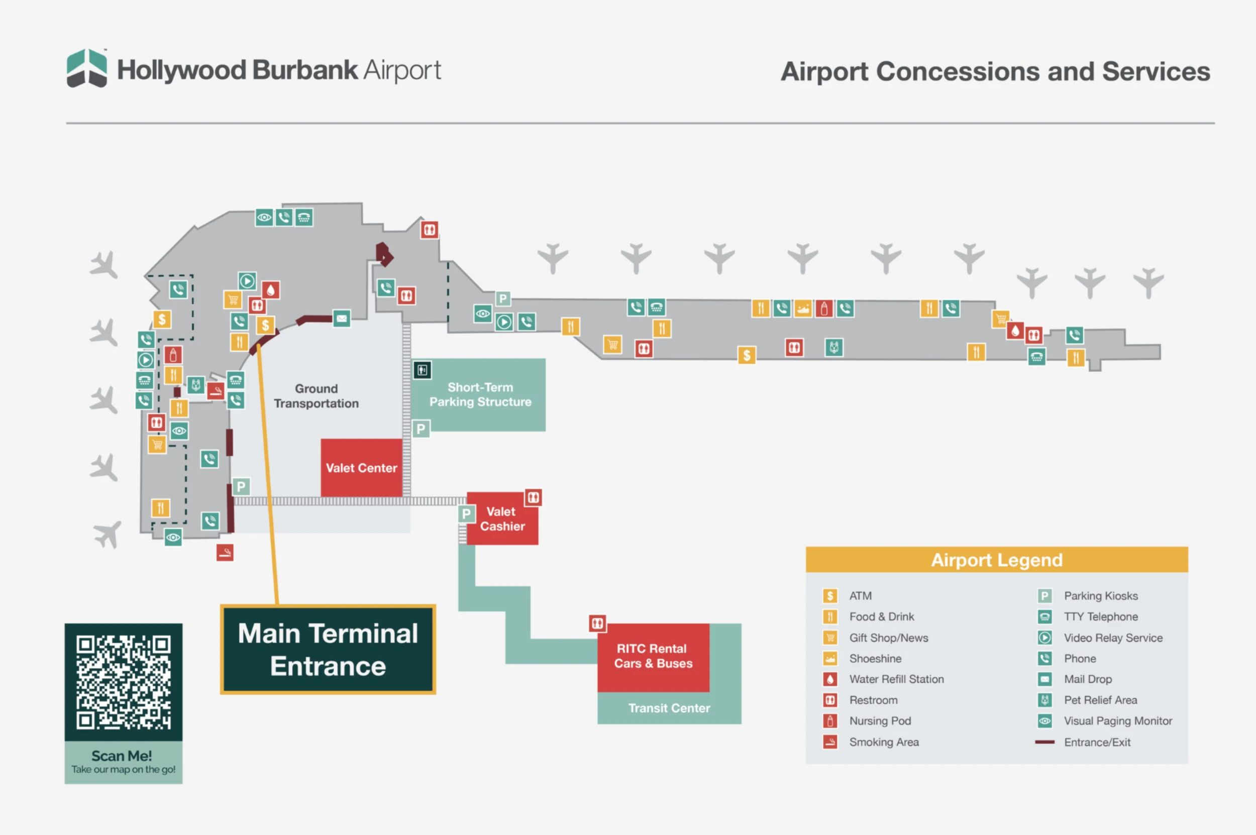
What is the exact walking route (and distance) from Terminal B arrivals curb to the rideshare pickup entry inside the short-term parking structure?
No rideshare pickup entry exists inside the short-term parking structure because Transportation Network Company pickups are prohibited there. The legal rideshare node is the West Island pickup zone in the ground-transportation islands directly across the arrivals lane from Terminal B.
Exiting Terminal B baggage claim, walk straight through the sliding doors to the arrivals curb, then use the marked crosswalk to cross the first vehicular lane to the ground-transportation islands. Continue to the West Island rideshare zone and stand in the signed pickup area before requesting your car. The walk from the Terminal B exit threshold to the center of the West Island pickup area is about 175 feet, and choosing the wrong node can trigger an 8–12 minute driver re-circulation if the six pickup spaces are full.
Which parking-garage level contains the designated rideshare pickup point, and what is the shortest path from that level to the terminal crosswalk?
No parking-garage level contains a designated rideshare pickup point because Transportation Network Company pickups are prohibited inside the short-term parking structure. The legal rideshare pickup node is the West Island on the ground-transportation islands outside the terminals.
From the short-term parking structure, take the elevator or stairs down to ground level, then exit toward the terminal frontage. Use the central pedestrian crosswalks that align with the Terminal A and Terminal B baggage-claim exits, cross the loop road to the islands, and walk to the West Island rideshare zone. If you try to meet a driver inside the structure, the driver may be forced to re-loop, adding roughly 8–12 minutes during peak congestion.
What is the exact walking distance from the terminal exits to the Burbank Airport–North rail/transit connection used as an alternate rideshare pickup node?
The walking distance from the terminal area to Burbank Airport–North Station is approximately 1.0 mile. That distance is the key dealbreaker for using it as an “alternate” pickup node on foot, because it typically takes about 17–20 minutes and runs along industrial frontage with limited shade.
From the terminal exits, the path runs out toward Hollywood Way and continues to the station area near the Hollywood Way and San Fernando Road corridor. North Station access is usually handled by the dedicated on-demand shuttle instead of walking; the pickup procedure requires calling for the shuttle, and the stop location differs by direction. If you attempt an alternate pickup there, plan it as a shuttle-based move, not a short walk from the terminal curb.
Where are the remote/economy lot shuttle pickup stops located, and what is the distance from each stop to the terminal entrance doors?
Remote/economy lot shuttles pick up and drop off at the ground-transportation island in front of Terminal A, placing you about 120 feet from the main ticketing entrance doors. That island is the practical “target” stop to memorize, because standing on the wrong island can cost a full shuttle cycle.
Economy Lot C passengers board at Lot C (3252 Thornton Avenue) and ride the complimentary shuttle to the terminal frontage, where the shuttle drop-off occurs at the Terminal A ground-transportation island. From that drop-off point, walk straight across to the Terminal A entrance. If you’re meeting someone or trying to optimize time, treat the island itself (not the curb) as the anchor point, since van and shuttle stopping patterns can shift slightly with traffic.
What is the exact park → shuttle → drop-off passenger flow at BUR, including the precise shuttle drop-off point relative to the terminal doors?
The park → shuttle → drop-off flow for Economy Lot C ends at the ground-transportation island directly in front of Terminal A, about 120 feet from the main ticketing entrance doors. That drop-off location is the operational anchor, because it determines your final crosswalk and the shortest walk into the building.
After you park in Economy Lot C (3252 Thornton Avenue), walk to the marked shuttle boarding area inside the lot, then wait for the complimentary airport shuttle (often 10–15 minutes at peak). Ride the shuttle to the terminal frontage and disembark at the Terminal A ground-transportation island. From the island, walk straight toward Terminal A and enter through the main ticketing doors; if you instead get off at or walk to the wrong island, you can lose several minutes repositioning through curb traffic and crosswalks.
During peak periods, where does the Southwest Airlines bag-drop overflow line physically form inside the ticketing hall (which side/zone)?
Southwest’s bag-drop overflow line typically forms toward the north side of Terminal A’s ticketing lobby, extending laterally in the direction of the terminal’s northern entrance doors (Doors 1 and 2). That overflow pattern is the main dealbreaker because it can become longer than the TSA wait and can physically obstruct the lobby flow.
Southwest occupies the central portion of the Terminal A ticketing hall, but when the stanchioned bag-drop area fills, the queue “spills” sideways rather than forward. The line commonly stretches toward the north entrance zone and can start to pinch the walkway used by passengers trying to pass toward other counters (including the American Airlines area). If you’re checking bags, arriving early matters more than how fast security looks at that moment.
What is the exact distance from the Southwest bag-drop area to the TSA queue start point (the bag drop → security transition length)?
The distance from the Southwest bag-drop area in Terminal A to the TSA security checkpoint entrance is approximately 220 feet. That short physical gap can still feel slow during peak periods because the lobby clogs where bag-drop overflow and security-bound passengers intersect.
Southwest’s counters sit in the central ticketing hall, and the primary Terminal A checkpoint is positioned near Gate A1. To make the transition, walk out of the bag-drop area into the main lobby aisle and continue toward the security queuing entrance. The most common delay isn’t the walk itself—it’s weaving through the stanchion spillover and passengers regrouping near the checkpoint, which can turn a one-minute walk into a multi-minute shuffle.
Where is the TSA PreCheck lane entrance positioned relative to the standard lane, and what is the shortest approach path from the ticket counters?
The TSA PreCheck lane entrance at the primary Terminal A checkpoint is typically on the far left side of the checkpoint entrance relative to the standard lane. That left-edge placement matters because the standard queue can spill into the main walkway and hide the PreCheck entry from sight.
From the Terminal A ticket counters, walk toward the primary security checkpoint near Gate A1 and stay left as you approach the queuing area. Pass the outer edge of the standard line (don’t join it), then cut directly into the PreCheck entry at the leftmost side of the checkpoint frontage. If the lobby is congested from Southwest bag-drop overflow, hug the wall-side edge to avoid getting trapped behind the standard queue’s stanchion line.
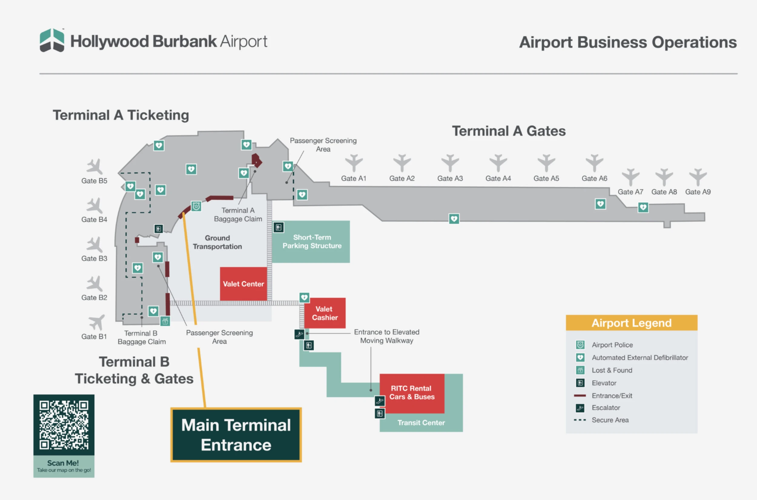
What is the exact walking time/distance from the TSA exit to the farthest gate area at BUR (verify precisely)?
The farthest post-security walk at Hollywood Burbank Airport is from the Terminal A TSA exit to Gate A9 at about 450 feet, which is roughly a 2-minute walk. That distance is short, but concourse pinch points during simultaneous boarding can add a couple of minutes if the aisle is blocked.
From the Terminal A checkpoint, turn into the main concourse and follow the linear gate corridor north toward the A-gates until you reach Gate A9. If your flight departs from the B side, the longest comparable walk is to Gate B5 at about 380 feet (around 1.5 minutes). When two adjacent gates are boarding at once, expect brief slowdowns where boarding lines and limited seating narrow the passage.
For passenger pickup, what is the fastest legal wait-zone → arrivals curb route, and what is the curb-entry point?
The short-term parking structure is the fastest legal wait zone because curbside waiting is strictly enforced. The quickest legal sequence is to stage in the structure, then exit via the northern exit lanes, loop onto the airport loop road heading south, and enter the arrivals curb immediately after the roadway curves past the Valet Center.
From your parking stall, drive to the structure’s exit lanes and choose the northern exit. Merge onto the internal loop road and stay in the flow toward arrivals rather than attempting to idle near Terminal A or Terminal B. The curb-entry point for arrivals pickup is the first arrivals curb access after you pass the Valet Center on the loop’s curve. Off-airport streets like Hollywood Way and Empire Avenue are poor substitutes during peaks because signal timing at the entrance can add up to 10 minutes.
Where are the taxi stand and non-rideshare ground transport pickup points located relative to Terminal B arrivals, and what is the shortest terminal-to-stand route?
The taxi stand is on the ground-transportation island directly in front of Terminal B, positioned east of the rideshare zone, about 100 feet from Terminal B arrivals. That makes it one of the quickest “legal pickup” options if the rideshare spaces at the West Island are jammed.
Exit Terminal B baggage claim through the sliding doors to the arrivals curb, then use the marked crosswalk to reach the ground-transportation islands. Turn toward the east side of the island system and walk to the taxi queue area. Hotel shuttles and off-airport parking shuttles typically use the central shuttle island between Terminals A and B; from Terminal B arrivals, that’s a short walk across the curb lane and along the islands, but it can be slowed by vans blocking the lane during peak waves.
With Lot A closed, what is the exact vehicle routing from the main airport entrance to remaining lots/garages, and where are their pedestrian exits into the terminal?
Lot A’s closure forces most drivers into the short-term parking structure, adjacent economy lots (E/G), or the Economy Lot C shuttle flow. The practical dealbreaker is choosing the wrong lot path and then paying the time penalty in walking or the shuttle chain (park → wait → shuttle → island → doors).
| Parking option | Vehicle routing | Pedestrian exit into terminal |
|---|---|---|
| Short Term Parking Structure | Enter the airport loop, follow signs for Short Term Parking / Parking Structure, take the structure entry lanes opposite the terminals | Ground-level crosswalks aligned with Terminal A and Terminal B baggage-claim exits |
| Economy Lot E | Enter the airport loop, follow signage for Lot E, take the lot entrance adjacent to Terminal A | Direct pedestrian path toward Terminal A; short walk to entrance doors |
| Economy Lot G | Enter the airport loop, follow signage for Lot G (covered / southeast), take the lot entrance on the southeast side of the terminal area | Direct pedestrian path toward the terminal frontage; walk to the nearest terminal entrance doors |
| Economy Lot C | Approach via Buena Vista Street → Thornton Avenue to 3252 Thornton Avenue (Lot C), park and board the airport shuttle | Shuttle drops at the Terminal A ground-transportation island; ~120 feet to the Terminal A entrance doors |


