Gerald R Ford International Airport Map (Most Up-To-Date)
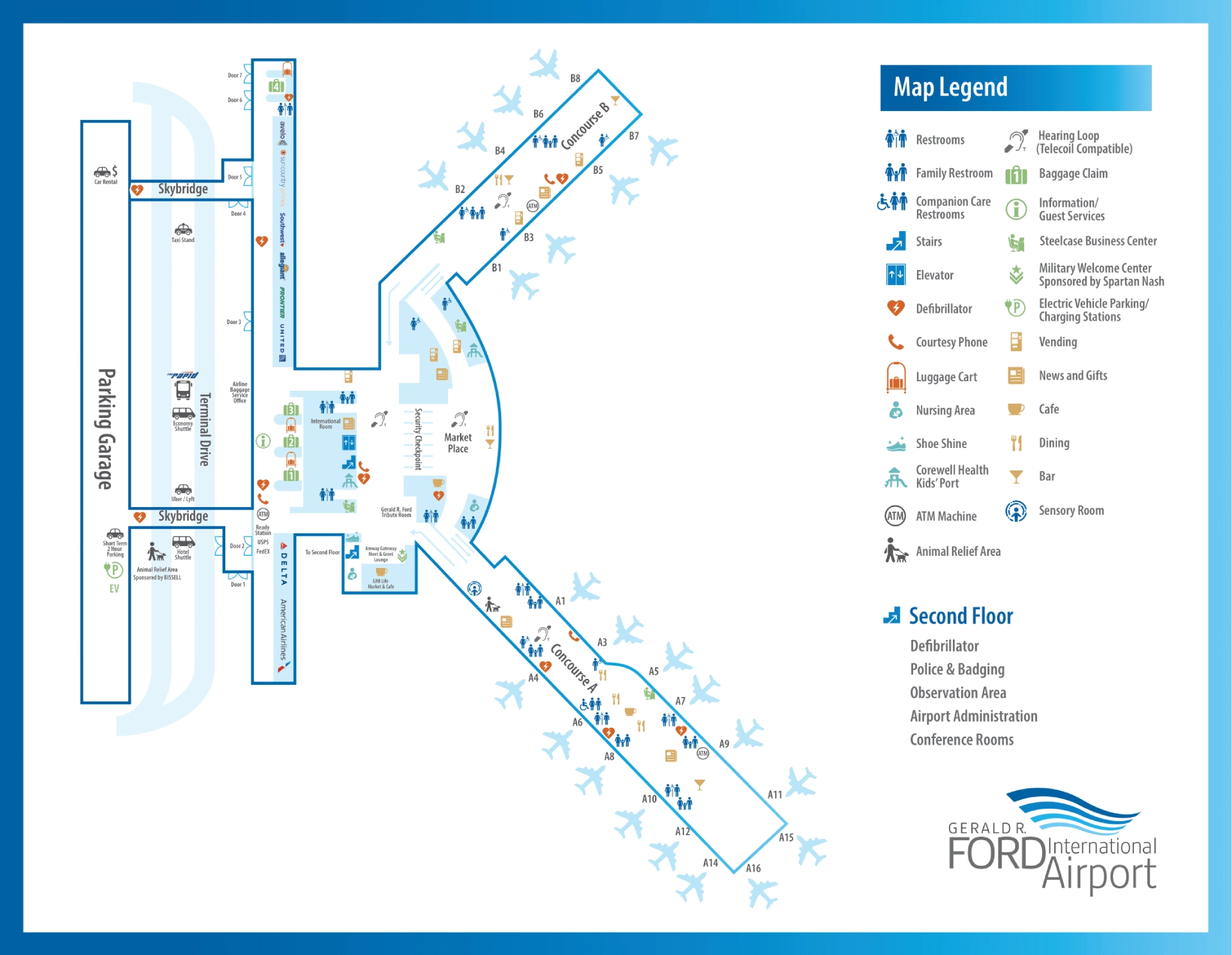
Gerald R. Ford International Airport’s terminal is a compact central core with two concourses branching from an upper-level Marketplace, while arrivals and ground transportation run along a single, straight curbline below. The building reads “small” from the curb, but the footprint stretches east–west: Concourse A now runs long, and landside pickup is door-zoned. Within West Michigan’s main airport complex, the fastest moves depend on using the correct door number and crossing to the boulevard island shelters.
Map Table
| Terminal | Key Airlines | Primary Function | Transfer Mode |
|---|---|---|---|
| Main Terminal (bi-level) | Delta, American, United | Ticketing, security, Marketplace | Walk |
| Concourse A (extended) | Delta, American, United | Gates A1–A15/A16 | Walk |
| Concourse B (compact) | Southwest, Allegiant, Frontier | Gates B1–B8 | Walk |
| Landside curb (Doors 1–7) | All carriers | Arrivals, pickups, shuttles | Crosswalk, curb walk |
Gerald R. Ford International Airport Map Strategy
- Treat Doors 1–7 as hard-coded “service nodes,” not interchangeable exits; pick your door before your bags hit the carousel.
- For rideshare, default to Door 2 and the boulevard-island shelter; curbside waiting on the inner lane creates instant pickup failure.
- For parking shuttles and buses, cross to the boulevard island shelters immediately; “inner curb” waiting is the most common cause of missed shuttles.
- Build a late-night backup plan around rental desk hours and baggage-delivery lag: move to the correct door/shelter first, then request transport from the mapped pin.
2026 Gerald R Ford International Airport Map + Printable PDF
Project Elevate’s concourse changes keep Gerald R. Ford International Airport feeling “reconfigured,” especially around Concourse A’s added length and the zoned curb rules. Door-based pickup still drives real-world outcomes: rideshare remains geofenced to a single exit path, and economy parking stays shuttle-dependent due to the remote lot distance. Use the 2026 map to lock in door numbers, curb islands, and the shortest indoor corridors.
2026 Gerald R Ford International Airport Map Guide
What is the exact walking route and distance (in feet/meters) from Baggage Claim to the official Rideshare Pickup zone at Gerald R. Ford International Airport?
The official rideshare pickup walk is about 250–350 feet (≈76–107 meters) from the center of Baggage Claim to the boulevard-island rideshare shelter, with Door 2 as the required exit. From the baggage hall, move west past the Visitor Information Desk toward Door 2, then exit at Door 2 and use the marked crosswalk to the boulevard island.
Use this landmarked path: start in the Lower Level baggage hall between the two carousels, walk west toward the Delta/United side, pass the Visitor Information Desk, and continue to Door 2. After stepping outside, cross the inner roadway immediately at the Door 2 crosswalk; the rideshare shelter sits on the boulevard island about 60 feet (≈18 meters) beyond the door threshold. If you exit at Doors 4–5 near the carousels, the correction is a curbside sidewalk walk roughly 300–400 feet (≈91–122 meters) back west to Door 2 before crossing.
Where is the Economy Lot shuttle pickup point at the terminal, and what is the exact walking distance from the Arrivals door to that pickup point?
The Economy Lot shuttle pickup is at the central boulevard-island transportation shelter across from the terminal curb, typically accessed from Doors 3–4 on the arrivals level. Walking distance from the Arrivals door to the shelter is about 60–80 feet (≈18–24 meters), using the nearest crosswalk from the inner curb to the island.
Use this landmarked path: exit the baggage claim hall through Door 3 or Door 4 (central doors by the atrium/baggage claim midpoint), then immediately cross the inner lane at the marked crosswalk to the boulevard island. The shuttle loads on the outer commercial lane side of that island shelter (not the inner curb). If you’re standing at the terminal-side curb under the door canopy, you’re on the wrong side—step to the island shelter to be in the actual pickup queue.
Which door number / curb segment is designated for rideshare pickup (Uber/Lyft), and what is its map location relative to baggage claim exits?
Door 2 is the designated rideshare pickup exit for Uber and Lyft, and pickups are geofenced to the boulevard-island shelter reached from that door. Relative to the baggage claim exits, Door 2 sits west of the central baggage claim doors (Doors 3–5), closer to the Delta/United ticketing side.
Rideshare works as a “Door 2 protocol” path: exit baggage claim, move west along the lower-level hallway toward Door 2, then cross the inner roadway at the Door 2 crosswalk to the shelter on the boulevard island. If you exit at Door 4 or Door 5 near the carousels, you will be east of the rideshare crossing and must walk back west along the curb to Door 2 before you can reach the correct shelter pin.
What is the exact path and distance from Economy Lot shuttle drop-off to the main TSA checkpoint entrance?
The shortest path from the Economy Lot shuttle drop-off to the TSA checkpoint entrance is under 200 feet (≈61 meters) when the shuttle unloads on the upper-level departures curb near the Grand Hall doors. From the curb, enter through the nearest upper-level door into the ticketing hall, then walk straight toward the central security queue.
If the shuttle unloads at a lower-level arrivals curb due to traffic routing (less common for departures), the dealbreaker is the level change: enter the terminal, take the central escalator/elevator up to the ticketing level, and then continue to the single consolidated TSA checkpoint. Use the Grand Hall as the anchor: once you’re in the open ticketing space, TSA is centered ahead, not split into multiple checkpoints.
Where are the two baggage carousels located on the Gerald R. Ford International Airport terminal map, and what is the standing space layout immediately around them (pinpoint the choke area)?
The two baggage carousels sit on the lower-level Baggage Claim hall, arranged along the linear east–west corridor parallel to the curb frontage. One carousel zone is on the west side near Doors 1–2, and the other is on the east side near Doors 5–6, with the main walking corridor running between carousel edges and the greeter/exit lane.
The choke area is the narrow “belt-to-walkway” band where passengers cluster at the carousel rim while through-traffic tries to pass behind them. The worst pinch happens when two flights feed adjacent carousel zones: luggage groups expand outward into the primary east–west path, forcing people moving between doors (for example, walking from the west carousel area toward Door 6 rental counters) to weave through a stationary wall of bags and bodies.
What is the shortest indoor route (and distance) from Baggage Claim to the Rental Car counters (or rental car access point) at Gerald R. Ford International Airport?
The shortest indoor route to the rental car counters is along the lower-level baggage hall to the east end near Door 6, with about 0–100 feet (≈0–30 meters) from the east-side baggage area and about 300–400 feet (≈91–122 meters) from the west-side baggage area. The counters are at the east end of the terminal, aligned with the Door 6 zone.
Use this landmarked path: from the baggage hall, face the curbside doors and walk east toward the rental-counter end of the hall (the side aligned with Door 6 and the garage/rental access). If you’re starting near the west carousel/Doors 1–2, stay inside and continue straight through the baggage claim corridor until the hall reaches the east-end counter cluster. After the counter, the garage vehicle area is reached by exiting near Door 6 and entering the parking structure, roughly 200 feet (≈61 meters) from the counter to the garage entry.
What is the exact walking distance from the Parking Garage pedestrian entry to the main terminal check-in hall (fastest dry-weather route)?
The fastest dry-weather walk from the parking garage pedestrian entry to the check-in hall is about 200 feet (≈61 meters) using the Level 2 skybridge into the Grand Hall. The skybridge avoids curb crossings and drops you directly into the pre-security ticketing/check-in space.
Follow this route: from the garage, go to Level 2 (elevator or stairs) and enter the enclosed skybridge corridor that connects garage Level 2 to terminal Level 2. Stay on the skybridge until it opens into the Grand Hall (ticketing/check-in). This path is faster than street-level exits because it bypasses the lower-level baggage area escalators and the curbside sidewalk congestion.
Where is the Starbucks location relative to TSA exit (post-security), and what is the maximum queue spill area on the concourse map (where the line blocks traffic)?
Starbucks is immediately post-security in the central Marketplace atrium, positioned in the open area passengers enter right after exiting the TSA checkpoint. The maximum queue spill area is the open floor space directly in front of the Starbucks kiosk where the line pushes back toward the TSA exit and sideways across the left/right split to Concourse A and Concourse B.
The blockage happens at the Marketplace “decision point”: passengers exiting TSA need to fan out left for Concourse A and right for Concourse B, but a long Starbucks line can occupy that same lateral corridor. If the queue extends past the kiosk footprint, it starts intersecting the main cross-traffic lane between the two concourse entrances, turning the security exit zone into a pinch point.
What is the exact route (turn-by-turn via map landmarks) from the main TSA checkpoint exit to the furthest gate in Concourse A?
The furthest Concourse A gate walk runs nearly 1,000 feet (≈305 meters) from the TSA exit to the far end gates (A15/A16 area), with Concourse A extending beyond the legacy end at Gate A7. From the TSA checkpoint exit in the central Marketplace, turn left into the Concourse A corridor and continue straight through the full length of the pier.
Follow this landmarked route: start at the TSA exit facing the Marketplace; turn left toward Concourse A. Pass Freddy’s (Steakburgers) and the initial block of gates A1–A7, then continue forward into the newer expansion section where the concourse widens and ceiling height increases. Stay on the main spine past the market-style concessions zone in the expansion, then continue to the very end of the pier for the furthest gates (A15/A16 area).
What is the exact route (turn-by-turn via map landmarks) from the main TSA checkpoint exit to the furthest gate in Concourse B?
The furthest Concourse B gate walk is the shorter pier route from the TSA exit, ending at Gate B8. From the TSA checkpoint exit in the central Marketplace, turn right into the Concourse B corridor and continue straight to the end of the concourse.
Follow this landmarked route: start at the TSA exit facing the Marketplace; turn right toward Concourse B. Pass Firehouse Subs and the Business Center as you proceed down the corridor, staying on the main path with gates branching along the sides. Continue to the end of the pier where Gate B8 is located.
Where are the Arrivals doors mapped relative to the curb lanes, and which door yields the shortest curb-to-baggage path (minimum crossings)?
The arrivals doors run in a straight numbered line (Doors 1–7) along the lower-level curb, with the inner curb lane used for private vehicles and the outer/boulevard side serving commercial traffic at island shelters. The shortest curb-to-baggage path with the fewest crossings is Door 4 for most passengers, because it aligns to the central baggage claim area and opens directly into the main baggage hall.
Door 4’s advantage is that it minimizes lateral walking inside the baggage hall and avoids the west/east end detours required by Door 2 (rideshare-only logic) or Door 6 (rental/garage bias). For private pickup at the inner curb, Door 4 keeps you on the terminal-side sidewalk with no required island crossing. For bus/shuttle access, you still cross once to the boulevard island shelter, but Door 4 remains the most central crossing point.
Where is the closest “walk instead of wait” route from the terminal to the Economy Lot boundary (the path people take when shuttle capacity fails), and what is the exact distance?
No “walk instead of wait” route exists from the terminal to the Economy Lot boundary because the Economy Lot is about 1.5 miles away (≈2.4 kilometers) across arterial roads without a safe, continuous pedestrian path. Walking is the failure condition: the layout makes the shuttle a 100% dependency rather than a backup option.
If shuttle capacity fails, the practical fallback is mode-switching at the terminal curb, not walking: use the taxi access near Door 3, or shift to private pickup at the inner curb after coordinating with a driver in the off-site Cell Phone Lot. The closest lot that remains meaningfully walkable is the North Lot, not the Economy Lot.
Archive Gerald R Ford International Airport Map
Below are all historical map versions for Gerald R Ford International Airport. Each year includes the official map available for that period, presented as both WebP and PDF.
2025-2026 Gerald R Ford International Airport Terminal Map (Official 2025 Edition)