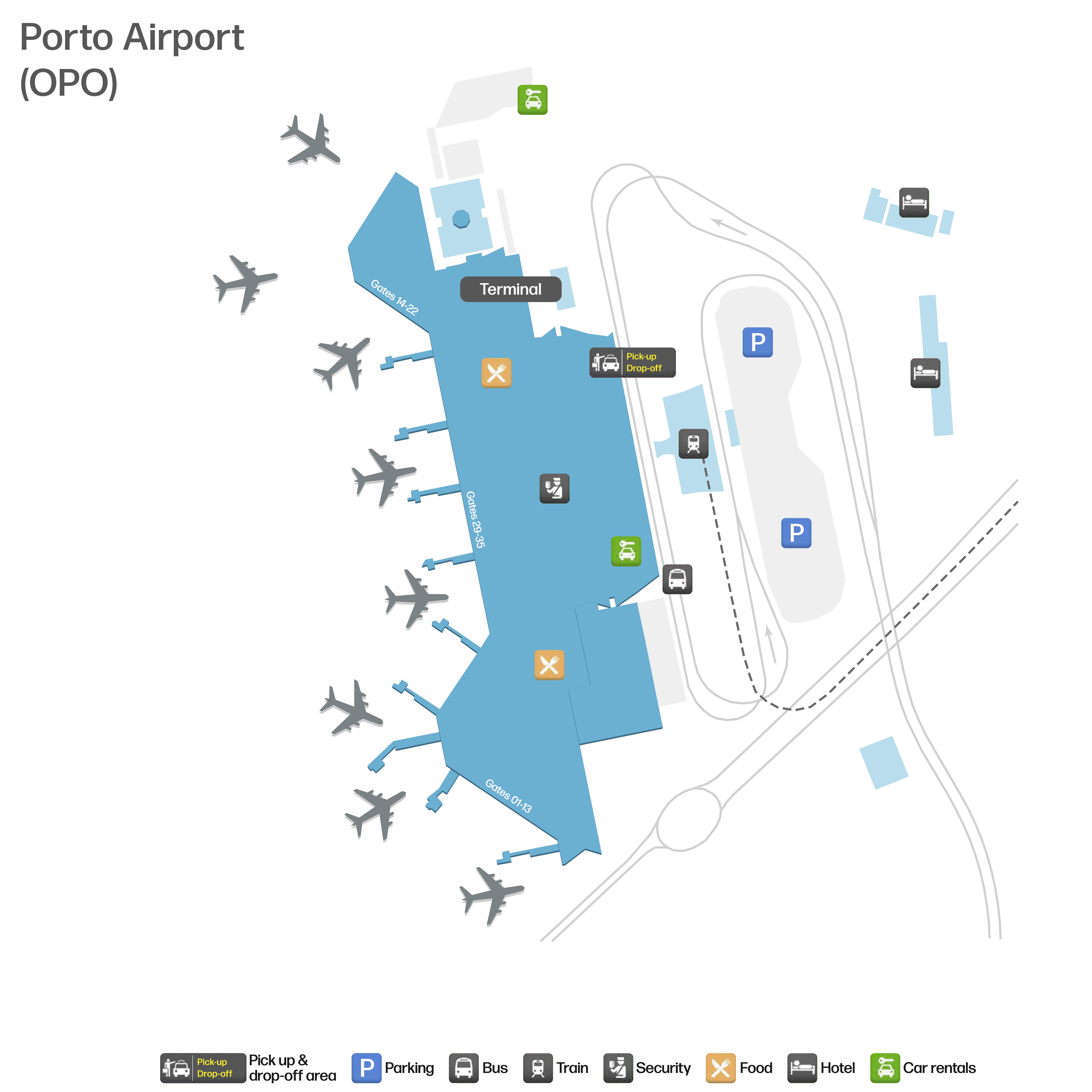
Francisco de Sá Carneiro Airport Map (Most Up-To-Date)
Francisco de Sá Carneiro Airport runs as a compact, single-terminal stack with Arrivals on Level 0, Check-in/Security on Level 3, and a V-shaped airside pier fed by a central retail atrium. The building is long and linear on the curb (north–south), then “fans out” after Security. Within Porto’s primary air hub, most mistakes come from choosing the wrong post-security corridor or the wrong curbside end.
Map Table
| Terminal | Levels | Airside Shape | Ground Access |
|---|---|---|---|
| Single terminal | Level 0 Arrivals, Level 3 Check-in/Security, Level 2 gates spine | Central atrium + V-shaped pier | Metro Line E, STCP buses, Taxi rank, TVDE north pickup |
Francisco de Sá Carneiro Airport Terminal Map Strategy
- Treat non-Schengen/UK departures as a two-step process: Security first, then immediately locate the downstream “Passport Control / Controlo de Passaportes” checkpoint and clear it before food, duty free, or the lounge.
- Use the map to pre-identify the Schengen vs non-Schengen split point in the retail atrium, plus the nearest FIDS screens and the exact corridor that feeds the border-control queue.
- For TVDE (Uber/Bolt), follow the curbside geometry: Arrivals doors → right turn → long northbound sidewalk to the blue “TVDE” sign; note the access gate into the pickup lot because it’s where vehicles stack and “arrived” cars can be invisible.
- Anchor all “problem solving” routes before you need them: Relay-store decision point for rental desk vs shuttle, the baggage-claim side desks for PIR/lost bags before exiting, and where the main Security queue begins spilling into the check-in hall during 05:30–07:00 peaks.
2026 Francisco de Sá Carneiro Airport Map + Printable PDF
Single-terminal operations remain the defining feature at 2026 Francisco de Sá Carneiro Airport, but real-world flow is shaped by time-of-day surges and two “surprise” choke points: Security overflow in early mornings and a second queue for non-Schengen/UK departures after Security. A printable map is most useful when it highlights the split corridor, passport-control doorway, and the long curb walk to TVDE pickup.
2026 Francisco de Sá Carneiro Airport Map Guide
What is the exact walking distance (meters) from the main Security exit to the first passport control queue point for non-Schengen/UK gates?
No single fixed meter distance is posted because the “first queue point” shifts with how far the passport-control line backs up into the airside atrium. In normal flow, the walk from the Security exit into the retail atrium and up to the passport-control entry is typically within the airport’s 300–500 meter security-to-non-Schengen segment, with the passport-control doorway being the functional start of that second choke point.
The practical way to measure it on a terminal map is to trace from the Security exit doors into the duty-free/retail atrium, then follow “Passport Control / Controlo de Passaportes” signage to the border checkpoint. If the line is long, the true “first queue point” can begin in the atrium itself near the main duty-free frontage, effectively adding distance before you even see the booths.
Where is the physical split point where Schengen passengers diverge from non-Schengen/UK passengers after Security?
The split point is the first clearly signed corridor break inside the central airside retail atrium where “Passport Control / Controlo de Passaportes” routes non-Schengen/UK passengers away from the open Schengen concourse. Schengen passengers continue straight into the main gate spine through the retail/dining zone, while non-Schengen/UK passengers peel off toward the passport-control filter before reaching their gate corridor.
Look for the Flight Information Display screens and the duty-free frontage immediately after Security as your anchor. From that central atrium, follow overhead signs for “Passport Control” (often bilingual) toward the pier extremity serving non-Schengen flights. If you can still freely access the food court and Schengen gates without passing a document check, you have not taken the non-Schengen/UK split yet.
What is the exact pedestrian route (turn-by-turn landmarks) from Arrivals to the TVDE ride-share pickup zone?
The TVDE pickup route is a right-turn, curb-parallel walk from the public Arrivals doors to the far north end of the terminal, ending at the blue “TVDE / Electronic TVDE” sign beside the dedicated pickup lot. The full walk is roughly 200–300 meters and feels longer because crowds thin out and the pickup area is physically separated from the main curb activity.
Exit baggage claim into the public Arrivals Hall (Level 0) and head to the main sliding doors to the curb. Step outside and turn right immediately, staying on the sidewalk under the terminal canopy. Walk past the taxi rank first, then continue past the STCP bus stop signage (lines posted on the curb). Keep going until you reach the end of the main terminal frontage where the waiting crowd is smaller; the dedicated TVDE area is marked by the prominent blue TVDE sign at the pickup lot entrance.
What is the exact location of the bottleneck gate/exit that constricts movement in the TVDE pickup area?
The bottleneck is the controlled vehicle-entry barrier gate at the mouth of the TVDE pickup lot, where cars queue in a single-lane funnel before they can enter the limited-capacity waiting area. This is the point that creates the “my driver has arrived but I can’t see them” problem because vehicles stack outside the gate while passengers stand inside the pickup zone.
From the Arrivals curb, the gate sits at the far north end of the terminal frontage, immediately beside the blue “TVDE / Electronic TVDE” sign that marks the ride-share area. The constriction happens right where the sidewalk and pickup lot meet: one access lane, one barrier system, and a small internal holding area. If you’re standing under/near the blue TVDE sign and looking toward the driveway into the lot, you’re facing the chokepoint.
Where are the car rental desks located relative to Arrivals (floor + corridor + nearest landmark)?
The car rental desks sit on Level 0 in the public Arrivals Hall, immediately after you exit Customs into the landside meet-and-greet corridor. They are positioned in the central stretch of the hall, not outside on the curb.
After baggage reclaim, walk through the “Nothing to Declare” exit into the public Arrivals Hall and stop before the sliding exterior doors. The main on-site rental counters line the hall along the same interior corridor used by greeters, close to the central flow of arriving passengers. Use the Relay convenience store area as your anchor: the rental desks are in the Arrivals Hall zone around that central retail cluster, before you commit to any exit doors for shuttles or curb pickup.
What is the exact location of the off-airport rental shuttle pickup point (curb/door/zone identifier)?
The off-airport rental shuttle pickup point is on the central road median directly outside the Arrivals Hall exit nearest the Relay store. It is not at the taxi rank and not across at the parking garages.
From the public Arrivals Hall (Level 0), use the Relay convenience store as your anchor and take the exterior doors behind/adjacent to it. Outside, cross the first traffic lane at the marked pedestrian crossing and stop on the central median/promenade. The shuttle pickup is on that median waiting zone; if you keep crossing to the far side toward the garages, you’ve gone past the pickup point.
Where is the airport/handler lost-baggage office located (floor + side + nearest carousel or doorway)?
The checked-baggage lost-baggage desk is inside the secure Baggage Claim area on Level 0, positioned along the wall near the carousels before the “Nothing to Declare” exit doors. This is the ground-handler interface point where you file a PIR (Property Irregularity Report) for missing checked bags.
Use the frosted-glass “Nothing to Declare” doorway as your anchor: the baggage service/handler desk is within the reclaim hall on the carousel side of that exit, not out in the public Arrivals Hall. If your issue is lost property in the public terminal (not checked baggage), the police (PSP) office is landside on Level 0 toward the north end of the terminal—on the same directional vector as the TVDE pickup walk.
What is the exact walking distance from the last baggage carousel to the lost-baggage desk?
No single fixed meter value applies because the “last carousel” changes by flight and the handler desk location is relative to the active carousel block and the reclaim exits. In practice, the lost-baggage/handler desk is positioned within the Level 0 baggage hall near the carousels and close to the “Nothing to Declare” doors, so the walk is usually short within the reclaim space rather than a long terminal traverse.
To measure it precisely on a map, identify your carousel first, then trace the shortest path inside the secure reclaim hall to the handler desk counter positioned near the reclaim exit doors. The key operational rule is distance-independent: file the PIR before you pass through the “Nothing to Declare” doors, because once you exit into the public Arrivals Hall, returning to the secure reclaim area is difficult.
Where is the metro station entrance relative to the main Arrivals exit (door number/side and distance in meters)?
The metro access starts immediately off the main Arrivals curb zone on Level 0 via the signed “Metro” route that drops you down from the Arrivals level toward the station approach. The entrance is not at the far north TVDE end; it is reached from the central Arrivals exit area by following the Metro pictograms.
From the main Arrivals sliding doors, stay in the central frontage and follow “Metro” signs to the vertical transition (escalators/lift/stairs) that leads into the metro access path. The airport’s own distance estimates place Arrivals-to-metro in the 100–150 meter range depending on your exact exit door and which vertical core you use, with the first clear “you’re committed to Metro” landmark being the down-going escalators/lift bank signed for Metro.
What is the exact indoor/outdoor transition point (doorway) that begins the shortest walk to the metro platform?
The shortest metro walk begins at the central Arrivals-level exit that lines up with the “Metro” signage leading directly to the down-going escalators/lifts for the station access route. That doorway is the functional threshold: once you step out and commit to the Metro-marked vertical core, you are on the shortest path.
Use the main Arrivals sliding doors as your anchor, then immediately target the first “Metro” sign cluster and the nearest escalator/lift bank that descends from Level 0. If you find yourself walking a long distance along the curb toward the taxi rank or TVDE end before dropping down, you’ve missed the shortest threshold and are taking a longer exterior loop rather than the direct Metro access.
Where is the lounge entrance located relative to the central airside spine (nearest gate cluster or landmark)?
The ANA Lounge entrance sits airside on an upper mezzanine close to the Gate 31/32 cluster, overlooking the central gates level. It is reached from the main airside concourse via the nearby escalators/elevators rather than by a long pier walk.
After Security, use the central retail atrium as your anchor and follow airside signage toward Gates 31–32. Near that gate cluster, look for the vertical access point (stairs/escalator/lift) up to the lounge level; the entrance is typically positioned just off that mezzanine landing. If you are headed toward non-Schengen/UK gates, treat the lounge as upstream of the passport-control filter and budget time to clear passport control after leaving the lounge.
What is the exact location where the early-morning Security line begins to overflow into public areas (landmark-based)?
The overflow begins on Level 3 in the main check-in hall when the Security “snake” fills and the queue backs out past the tensabarrier maze into the open space in front of the central Security entrance. It becomes visible as a standing line that cuts across the check-in circulation lanes.
The landmark to use is the central Security doorway itself (the main entrance into screening) between the blocks of check-in counters. When the surge hits (roughly 05:30–07:00), the line stops being contained in the roped maze and starts extending outward into the hall, sometimes running parallel to the counter fronts and forcing passengers to weave around it. If you can’t immediately see where the line starts, look for the first roped segment nearest the Security entry and follow the crowd backward into the hall.