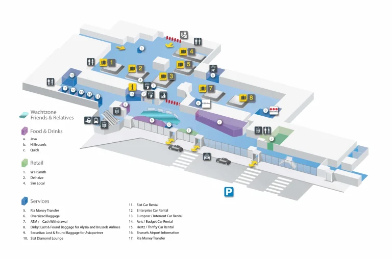
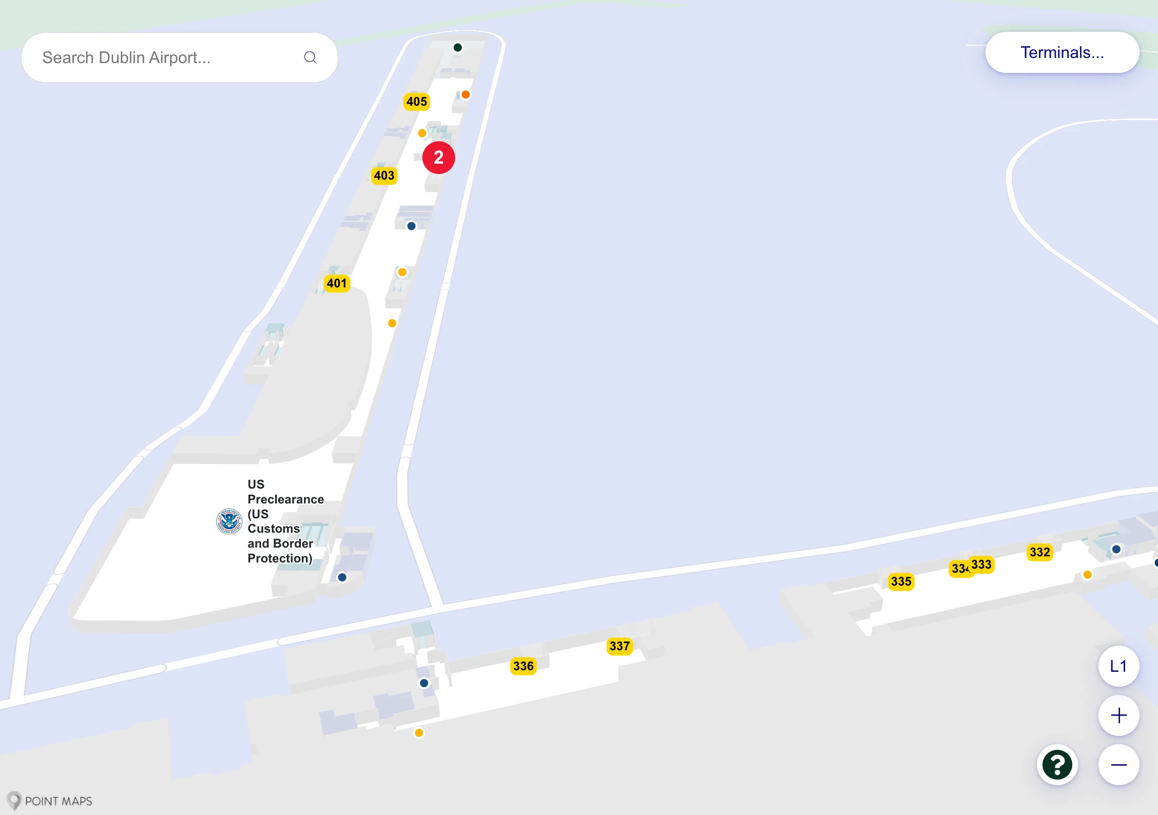
Dublin Airport Terminal 2 Map (Most Up-To-Date)
Dublin Airport Terminal 2 is a curving, two-level terminal inside Dublin’s primary airport hub, built around a central atrium that stacks processes vertically: Ground Level for check-in/arrivals functions and Level 2 for departures security, retail, and the main airside “Hub.” From the Hub, the airport splits hard in two directions: south/east to Pier 4 (400 gates and US Preclearance) and north/west into the Link Corridor toward Terminal 1 areas and bus-gate operations.
Map Table
| Zone | Connection | Walk Time |
|---|---|---|
| Check-in Hall (Ground) | Central escalators/elevators | 1–3 min vertical |
| Departures Security (Level 2) | “T2 Departures Security” e-gate comb | 1–2 min from escalators |
| Airside Hub (post–The Loop) | Split: 400s vs 100–300 | 0 min decision node |
| Pier 4 (400 gates) | SE escalators down from Hub | short to 400s |
| Link Corridor (100–337) | NW passage from Hub | long walk risk |
| Gate 335 (bus station) | Link Corridor → down to Ground | +20–30 min buffer |
Dublin Airport Terminal 2 Map Strategy
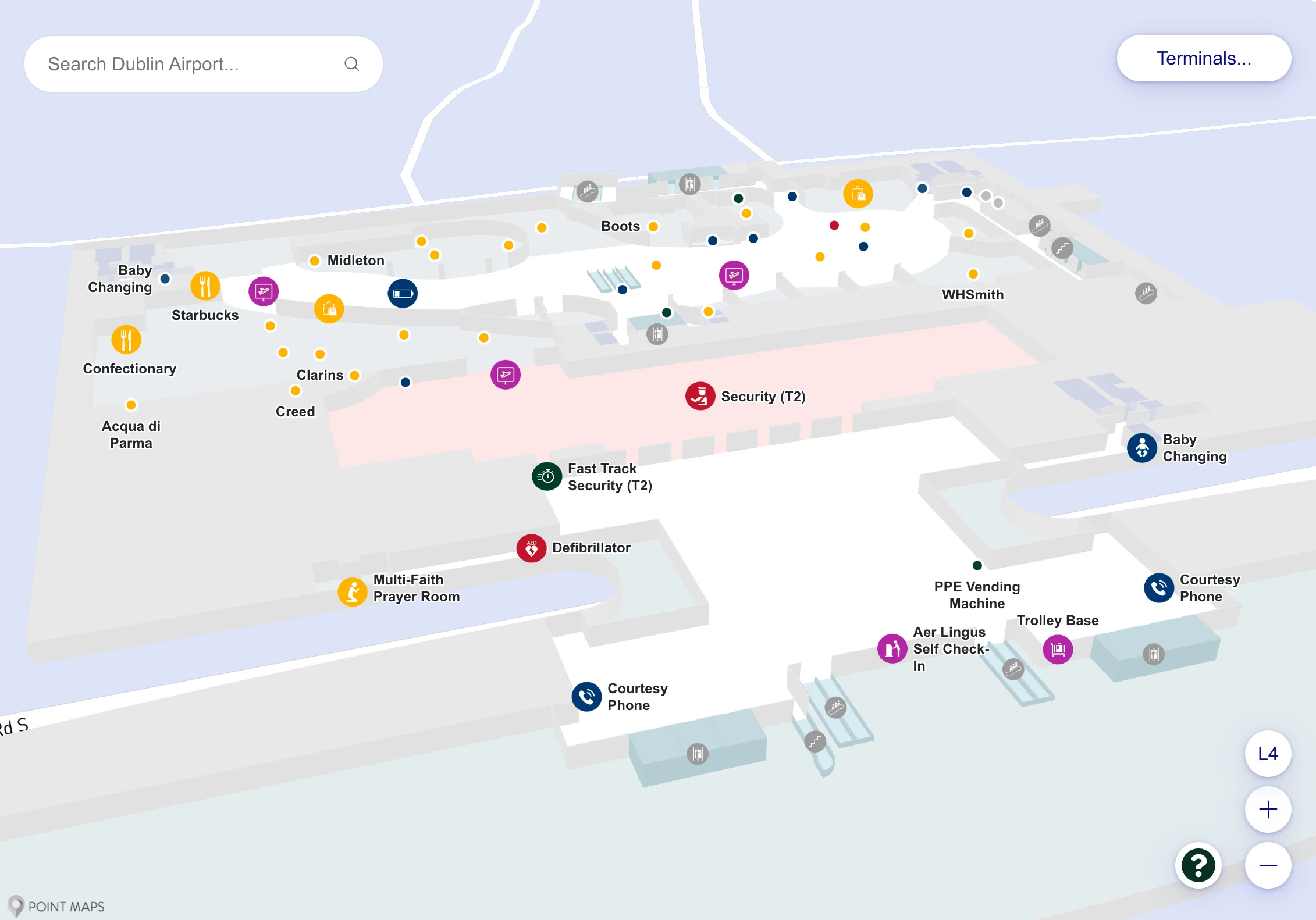
- Treat the top of the central escalators as your first “no-return” choice: the Level 2 e-gate comb labeled “T2 Departures Security.” Once you scan in, landside fixes are effectively gone.
- Fast Track success starts before you queue: on Level 2, face the screening area and stay left immediately (Fast Track lane on the left flank), instead of drifting into the center/right standard lanes.
- Let the gate number decide your entire route at the Hub: 401–426 means take the SE 400-gates escalators down; any gate under 400 means the opposite NW passage toward “Gates 100–300 / Terminal 1,” even if you started in Terminal 2.
- Treat “335” as a bus-transfer workflow, not a normal gate: the access point is reached via the Link Corridor, then a descent to the Ground Level gate-335 holding/scan area before buses run to Gates 335A–F—there is no direct Pier 4 shortcut to “South Gates.”
2026 Dublin Airport Terminal 2 Map + Printable PDF
Terminal 2’s core layout remains the same in 2026: check-in below, then a committed entry into departures screening via the Level 2 boarding-pass e-gates, followed by The Loop into the airside Hub where gate routing diverges. The biggest time traps still come from Fast Track lane positioning, long Link Corridor walks for sub-400 gates, and Gate 335 feeding bus operations to the 335A–F “South Gates” facility.
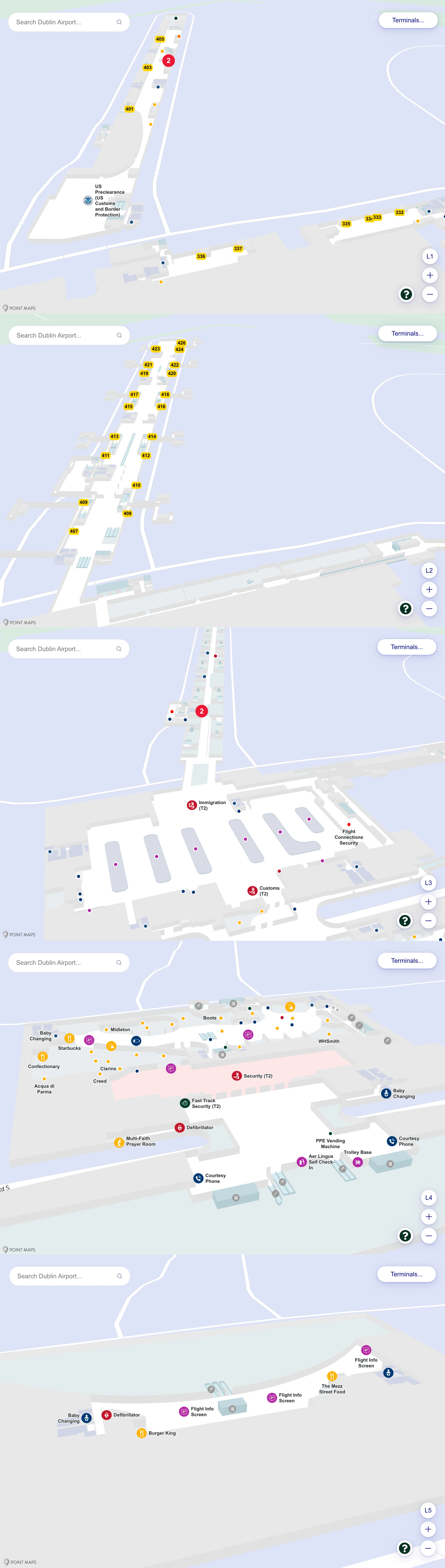
Dublin Airport Terminal 2 Level 1 Map 2025
Dublin Airport Terminal 2 Level 2 Map 2025

Dublin Airport Terminal 2 Level 3 Map 2025
Dublin Airport Terminal 2 Level 4 Map 2025
Dublin Airport Terminal 2 Level 5 Map 2025
2026 Dublin Airport Terminal 2 Map Guide
What is the exact map-labeled entrance point to Terminal 2 “Departures Security” from the check-in hall (i.e., the first decision point where travelers commit to the security queue)?
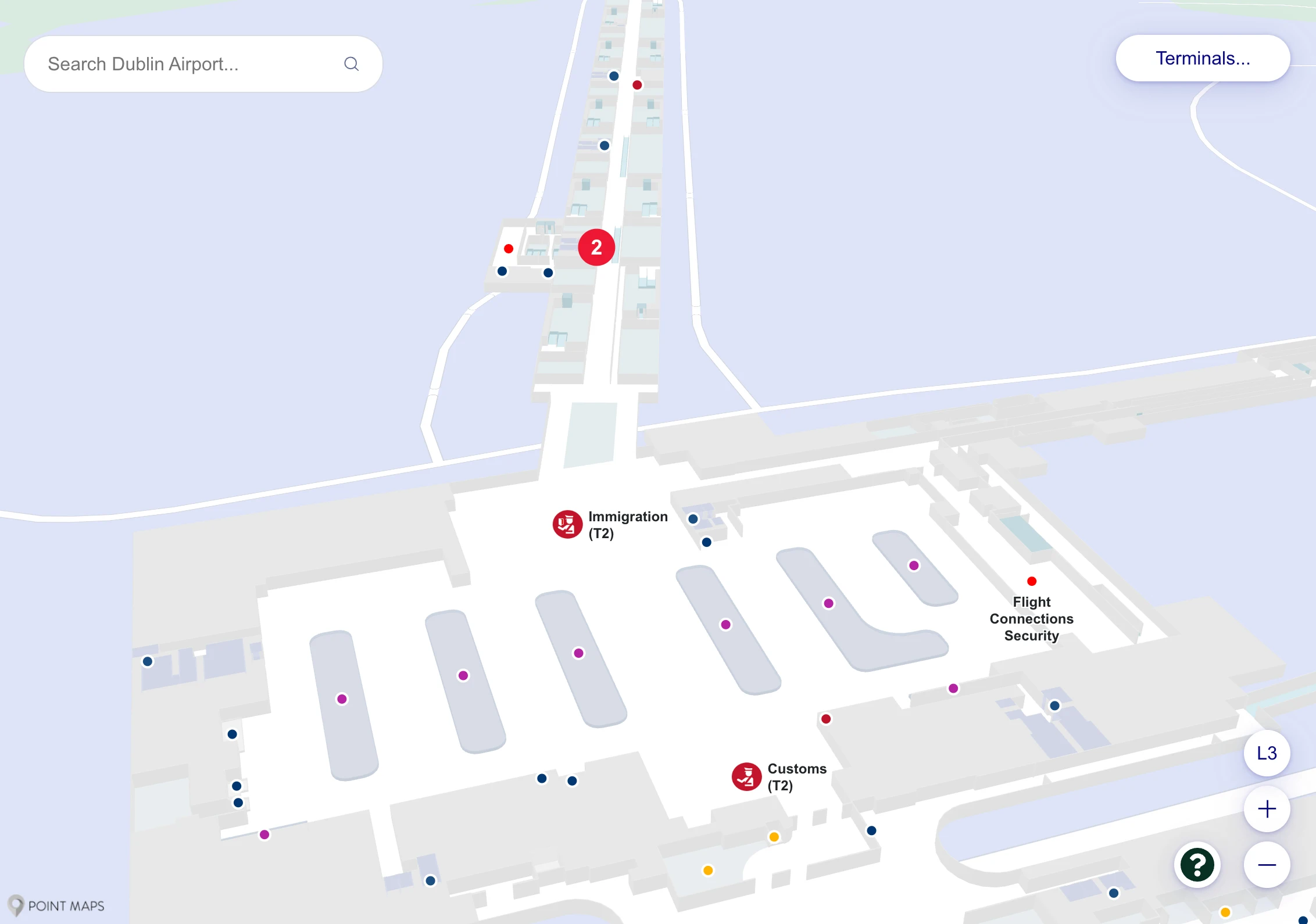
The map-labeled commitment point is “T2 Departures Security” at the Level 2 boarding-pass e-gates (the scanner “comb”) directly facing the top of the central escalator bank from the check-in hall.
From Ground (check-in), go up the central escalators/elevators to Departures Level 2, then aim straight ahead to the wide line of automatic boarding-pass scanners labeled “T2 Departures Security” / “Passenger Screening Area.” This is the first hard decision point because scanning your pass puts you into the security queuing matrix; the closest “you’re in the right place” landmark is the Out-of-Gauge (OOG) baggage area and landside concessions nearby on the Level 2 atrium edge.
Where is the Fast Track security entry physically located relative to the standard security queue entrance in Terminal 2 (same bank vs separate corridor), as shown on the map?
Fast Track is on the left-hand side of the same Level 2 security entrance bank when you face “T2 Departures Security” from the landside atrium.
On the map and in the space, the standard security entry is the broad central/right flow into the same screening hall, while Fast Track is a segregated lane on the western (left) flank of that e-gate/queue frontage. The practical landmark is the top of the central escalators: instead of drifting into the middle queues, you cross the atrium and hold left to the Fast Track channel before you commit into the main stanchioned lines.
Which exact corridor/junction connects Terminal 2’s main airside concourse to the “400 gates” zone (the point you’d follow if told to head toward 400s)?
The connector is the SE corner of the airside Hub at the “Gates 401–426” escalator/elevator bank that descends from the Hub level into Pier 4.
After security you’re forced through The Loop and then emerge into the circular airside Hub. From that Hub, follow the overhead signage for “Gates 401–426” toward the south-east edge where a prominent down escalator bank (with a flight-information totem typically at its head) drops you into the 400-gates spine. This is the commitment point: once you go down, reversing back to the Hub and the Terminal 1 link is slow and against the main flow.
Where is the map-marked access point from Terminal 2 into the “Gates 335A–F” holding area (the bus-gate pen), including the last named landmark before it?
The access point is “Gate 335” on the Ground Level of the Link Corridor (the 300-gates connector toward Terminal 1), reached by going NW from the T2 Hub and then descending to the Gate 335 bus-station level.
From the airside Hub, follow signs for “Gates 100–300 / Terminal 1” into the Link Corridor (300s). The last reliable named landmark before you’re committed is the Gate 335 signpost/junction within the 300-gates Link, where you stop following the flat concourse and instead take the stairs/elevator down to Gate 335 (the scan-and-wait pen). That Gate 335 pen is what feeds the buses to Gates 335A–F (“South Gates”)—it is not a normal jet-bridge gate.
On the terminal map, what is the exact walking route from Terminal 2 Security exit to the Aer Lingus Lounge entrance (the corridor it sits on)?
Walking goes from the security exit → The Loop duty-free → the airside Hub → the “Gates 401–426” junction, then you stay at Hub level and turn into the “Airline Lounges” access beside the 400-gates escalators to reach the Aer Lingus Lounge entrance.
After you clear screening, follow the forced path through The Loop until it opens into the circular Hub. Head toward the Gates 401–426 signage at the Hub’s south-east edge, but do not descend into Pier 4. Instead, take the adjacent Airline Lounges / Aer Lingus signed access (the lift/stair core beside the 400-gates escalator head). That lounges corridor sits right next to the 400-gate descent junction, which is why people accidentally go down toward Pier 4 when they’re aiming for the lounge.
What is the exact map route from the Aer Lingus Lounge corridor to the 300-gates direction split (the “turn” that determines 300 vs 400 flow)?
The split happens back at the airside Hub: leaving the Aer Lingus Lounge access, you return to the Hub and then either face the SE “Gates 401–426” escalators down or turn away to the NW passage signed “Gates 100–300 / Terminal 1.”
From the Aer Lingus Lounge entrance area, walk back out to the open circular Hub atrium (the same node you used to reach the lounge beside the 400-gate junction). The decisive “turn” is made here: staying near the south-east edge keeps you aligned with the 400-gates descent, while rotating across the Hub to the opposite side lines you up for the Link Corridor entrance marked for 100–300 gates.
Where does the “Flight Connections / Transfer” path from arriving 400-gates passengers enter the passport-control area (exact entry point on the connections map)?
Re-clearing immigration is required on the Flight Connections path because the connections stream feeds into the Irish Border Control / Passport Control entry at the Terminal 2 Flight Connections Centre, before you can re-enter departures.
Arrivals from the 400 gates (Pier 4) funnel back toward the main terminal block, then split under overhead signs for “Baggage Reclaim / Exit” versus “Flight Connections” (typically green wayfinding). Following Flight Connections takes you into the T2 Flight Connections Centre where your boarding pass is verified and you route toward the Passport Control access point for transit processing. After passport check (and any required security step), the connections flow deposits you back into the Terminal 2 airside Hub (Departures Level 2).
What is the exact location of the “alternative flight connections” passport-control checkpoint (the mini passport control) relative to the main arrivals passport control on the map?
The “alternative flight connections” checkpoint is in the Terminal 1 connections/arrivals stream, separate from the main Terminal 2 Arrivals Passport Control used by most inbound passengers.
On the airport’s functional layout, the main passport hall sits on the primary Arrivals route for Terminal 2, while the alternative option is positioned as a failover connections node where flows that are effectively in Terminal 1 (including many high-number 300 gates that physically sit in the T1-linked infrastructure) can process without walking all the way back through Terminal 2’s arrivals system. Use it when signage pushes you into T1 Flight Connections rather than the main T2 arrivals passport hall.
What is the exact landside walking path between Terminal 2 and Terminal 1 entrances (the mapped connector route and its named waypoints)?
Walking landside uses the enclosed internal pedestrian corridor on the Arrivals/Ground Level, linking Terminal 2 and Terminal 1 in about 3–5 minutes.
From Terminal 2, go to Arrivals (Ground Floor) and exit the secure baggage hall into the public meeting area. Instead of leaving to the curb, turn right/north and follow signs for Terminal 1 into the glass-walled internal walkway that runs along the terminal roadways. Stay in the corridor past the landside check-in frontage until it delivers you into the Terminal 1 Arrivals side, where you can continue to the T1 entrances/check-in areas.
If a traveler starts in Terminal 2 but is assigned a non-400 gate, what is the exact map-indicated decision rule (gate-number split) that tells them they’ll be walking toward Terminal 1 areas?
Any gate number below 400 means you must leave the Terminal 2 Hub and take the NW “Gates 100–300 / Terminal 1” Link Corridor instead of going down to Pier 4.
Use the Hub as the decision node: 401–426 routes you to the SE “Gates 401–426” escalators into Pier 4 (stay in Terminal 2), while 100–337 routes you the opposite way into the Link Corridor that blends into Terminal 1 infrastructure. Gate 335 is its own special case within “below 400”: it requires a further descent to Ground Level at the Gate 335 access point for bus transfer to 335A–F (South Gates).
Where is the Terminal 2 Arrivals pickup access point (the exact curb/roadside entry shown on maps) relative to the Departures set-down zone?
Arrivals pickup is on the lower roadway (Ground/Level 1) directly beneath/parallel to the upper Departures set-down road (Level 2) at Terminal 2.
Departures set-down feeds the upper level, dropping you straight into the departures/check-in atrium on Level 2, while the Arrivals road runs underneath on Ground Level for the arrivals stream. Operationally, the curb functions differ: the Arrivals curb is controlled for taxis/commercial traffic, while private pickups are typically routed to the Short Term Car Park rather than stopping freely at the lower curb.
What is the exact map route from Terminal 2 baggage reclaim exits to the short-stay/parking pickup area (the first named landmark outside baggage reclaim)?
Walking goes from Baggage Reclaim → Customs exit into Arrivals Hall → the glass-covered pedestrian bridge/walkway into the Short Term Car Park atrium.
Exit the baggage reclaim area through the Customs boundary into the public Arrivals Hall (Ground Floor). The first named landmark to look for immediately outside the reclaim stream is the signed pedestrian bridge / covered walkway to the Short Term Car Park—you follow that bridge instead of going out to the roadway curb. The bridge leads directly into the car park’s central atrium, where the pay stations and lifts to the parking decks are located.
On the map, where are the “south gates / bus gates” bus-boarding points located relative to the main Terminal 2 concourse (the final branching point before you’re committed to a bus operation)?
The bus-boarding commit point is Gate 335 on the north-west vector from the Terminal 2 airside Hub, reached via the Link Corridor (300 gates) and then a descent to Ground Level into the Gate 335 holding/scan area.
From the Hub, you do not head toward the Pier 4 (400s) escalators. You follow signs for “Gates 100–300 / Terminal 1” into the Link Corridor, continue until the Gate 335 access is signed, then take the stairs/elevator down—that descent is the final branch where you stop being on the normal concourse and enter the bus-gate workflow. The actual 335A–F South Gates are reached only after boarding buses from this Gate 335 pen.