Cologne Bonn Airport Map (Most Up-To-Date)
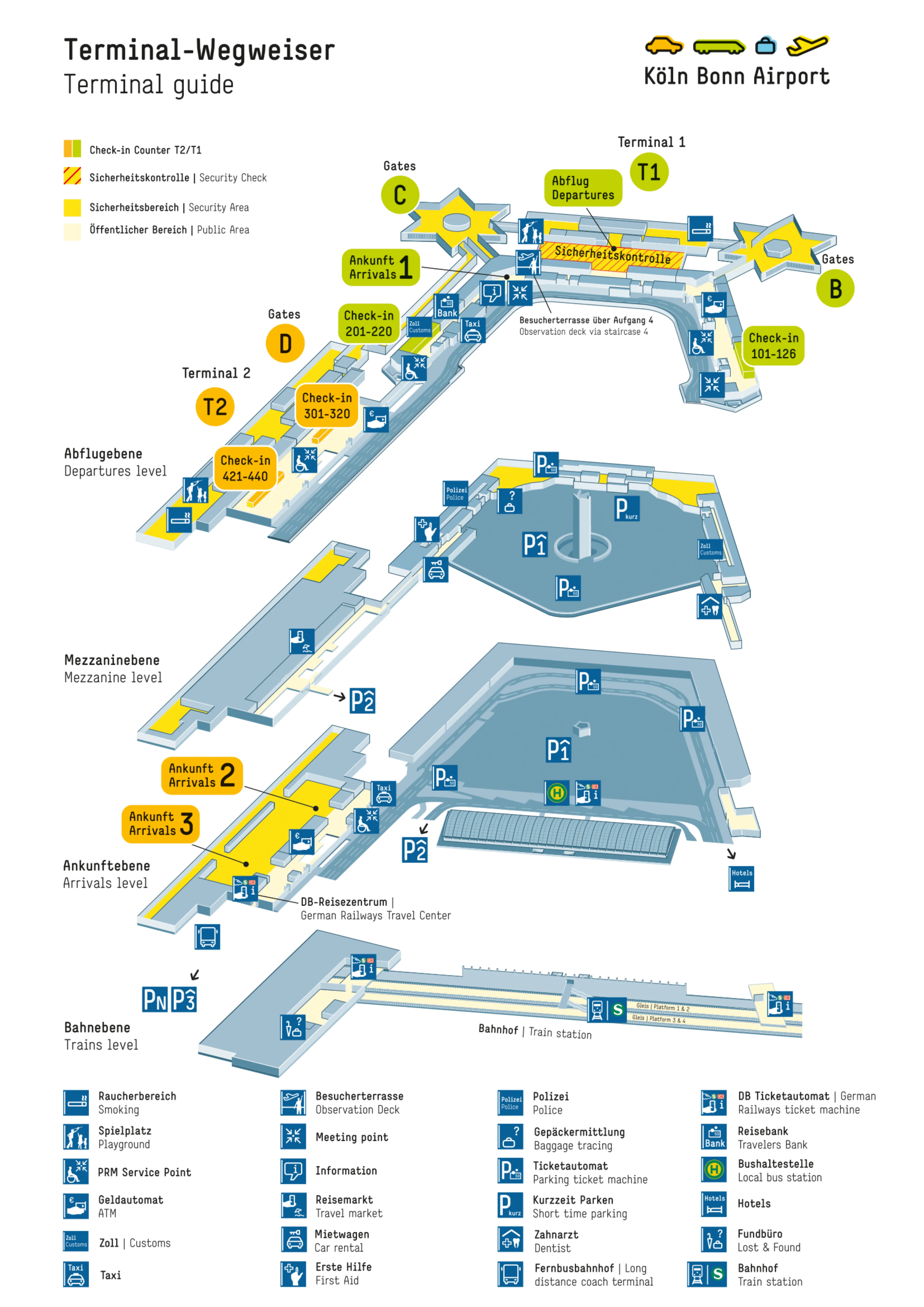
Cologne Bonn Airport runs as a two-terminal, side-by-side layout: Terminal 1 is the older “concrete star” with B/C piers, while Terminal 2 is the newer rectangular hall feeding D/E gates. The site is compact, but time risk spikes because the Cologne–Bonn air hub funnels passengers through Terminal 1’s centralized security, then often forces a post-security walk toward Terminal 2’s D-gates corridor and, for non-Schengen flights, onward passport control.
Map Table
| Terminal | Key Airlines | Primary Function | Transfer Mode |
|---|---|---|---|
| Terminal 1 (B/C) | Lufthansa, Eurowings, Austrian | central security hall, legacy pier walks | airside connector to Terminal 2/D, 5–10 min walk |
| Terminal 2 (D/E) | Ryanair, Corendon, Iran Air | LCC volume, bus gates, linear concourse | landside link to Terminal 1, rail escalators below |
| Rail Station (below core) | S13, S19, RE, ICE | underground injection point | central escalators, “wrong escalator” risk |
Cologne Bonn Airport Map Strategy
- Treat Terminal 1 central security as the fixed bottleneck and build your buffer around it, even if your gate is in Terminal 2 (D/E).
- After security in Terminal 1, commit immediately to the connector direction toward Terminal 2/D-gates; missing that early decision can dump you into B/C piers and force time-wasting backtracking.
- For UK/non-Schengen departures, plan for passport control as a separate queue after the airside walk; the last “easy” decision point is before you climb/commit into the non-Schengen departure level/zone.
- Use “correct door” discipline: rail platform position, parking garage level/exit, and terminal entrance choice decide whether you arrive at the right security façade (especially if using the CGNGateWay separate entrance).
2026 Cologne Bonn Airport Map + Printable PDF
Queue behavior, not terminal size, is what breaks trips at Cologne Bonn Airport in 2026. Terminal 1’s central security remains the universal choke point, and many departures still depend on a post-security traverse toward Terminal 2’s D-gates corridor. Non-Schengen routes add a second choke point at passport control after that walk, so a printable map is most valuable for “correct door” decisions before you commit.
2026 Cologne Bonn Airport Map Guide
What is the exact walking route (and distance) from the Terminal 1 central security exit to the Terminal 2 “D” gates corridor?
The airside walk takes about 5–10 minutes and runs roughly 400–600 meters from the Terminal 1 central security exit to the Terminal 2 D-gates corridor.
The route starts in Terminal 1’s post-security central hall (the marketplace immediately after the screening belts). Turn left relative to the main “toward B/C piers” flow, following the connector direction toward Terminal 2 rather than committing into Pier B or Pier C. Stay on the functional linking corridor/walkway (less retail, more transitional passage) until it feeds directly into Terminal 2’s D-gate concourse area. The key anchor is avoiding the star-pier entrances; if you pass deep into B/C, you’ve missed the connector and will need to backtrack to the central hall.
Where exactly is the Terminal 1 central security entrance relative to the Terminal 2 landside pedestrian link (fastest correct-door path)?
The fastest correct-door path is entering Terminal 1 directly into the central departures hall and aiming for the central security façade before you commit into the Terminal 2 landside connector corridor.
Terminal 2 and Terminal 1 are joined landside by an internal pedestrian link; taking that link from Terminal 2 drops you into the Terminal 1 main building, where the central security checkpoint sits as the dominant processing front in the open hall. The critical decision point is at the Terminal 1 hall “node”: one direction feeds outward into the B/C star piers, and the other keeps you in the central security/retail bowl. To stay on the correct path, follow departures/security cues into the central hall and stop at the checkpoint façade (where general queues and the separate CGNGateWay access vector split) rather than drifting toward the pier corridors.
Where is the passport control location on the Cologne Bonn Airport airside path for Schengen → UK/non-Schengen departures, and what is the last decision point before you’re committed to that queue?
Passport control sits in Terminal 2 departures as a centralized bank separating the Schengen airside retail bowl from the non-Schengen gate zone (D/E), and it can become the connection-breaking queue.
After the Terminal 1-to-Terminal 2 airside connector deposits you into Terminal 2’s Schengen airside area, the route to UK/non-Schengen gates requires moving up into the international departures level/zone where the Bundespolizei checkpoint controls entry. The last clean decision point is in the Terminal 2 Schengen airside concourse before you take the vertical path or corridor that funnels into the non-Schengen barrier—once you pass into that controlled approach, you’re effectively committed to the passport-control line and can’t “reroute” around it without backtracking out of the barrier area.
What is the exact walking route (and distance) from Terminal 2 arrivals level to the Terminal 1 central security entrance (for passengers dropped at Terminal 2)?
The landside transfer takes about 10–20 minutes and typically covers roughly 600–900 meters from Terminal 2 arrivals into Terminal 1’s central security entrance, depending on where you enter Terminal 2.
From Terminal 2, stay landside (do not go upstairs toward gates) and follow the internal pedestrian link connecting Terminal 2 to Terminal 1. Use the Terminal 2 main hall as your anchor, then take the corridor that leads into Terminal 1’s main building. Once you surface into Terminal 1, orient toward the open central departures hall—this is the node that feeds the B/C piers—and walk straight to the central security checkpoint façade. The “wrong turn” failure mode is drifting toward Terminal 2’s vertical circulation or exiting outside; the correct path stays entirely indoors via the connector until you’re facing Terminal 1’s security queue front.
Where is the CGNGateWay time-slot separate entrance located, and which corridor/landmark confirms you’re in the right place?
The CGNGateWay entrance is a separate access point on the perimeter of the Terminal 1 central security checkpoint façade, not inside the general queue maze.
The location anchor is the Terminal 1 post-check-in central hall where the security belts form a single large screening front. Instead of joining the main “Economy/General” queue lanes that build outward into the hall, scan the outer edge of the checkpoint face for CGNGateWay branding and a distinct lane divider that feeds directly to a screening belt. The confirming landmark is that you are still in the open central hall facing the checkpoint front (not down a pier corridor), and you can see the general queue accumulation area to one side while the CGNGateWay access vector stays separated and more direct into the belt area.
From the S-Bahn station platform, which end/entrance is the shortest path to Terminal 1 departures/security, and what are the key wayfinding markers on that route?
The shortest path uses the central escalator/elevator clusters from the underground station rather than the platform extremes, because Terminal 1 access is concentrated near the middle.
Move along the platform toward the central vertical-transport nodes (typically aligning with platform sectors C/D rather than the far A/F ends). Take the escalators signed for Terminal 1, then follow “Departures/Abflug” and security cues into the Terminal 1 main hall. The key markers are the shift from the enclosed station tunnel into the more concrete, enclosed Terminal 1 interface, and then the open central departures hall where the security checkpoint façade dominates the space. If you surface into a brighter, glassier hall with apron views, you’ve likely come up into the Terminal 2 side and will need the landside connector back to Terminal 1.
From the S-Bahn station platform, which end/entrance is the shortest path to Terminal 2 departures (D gates direction), and what are the key wayfinding markers on that route?
The shortest path uses the platform section under the “daylight” glass-roof interface and the central escalators signed for Terminal 2, because that vertical egress surfaces directly into the Terminal 2 hall.
On the platform, move toward the middle (avoiding the far sector ends) and look for the area where natural light is visible above—this is the glass-roof beacon that corresponds to Terminal 2. Take the escalators/elevators signed for Terminal 2, then follow departures signage into the Terminal 2 hall and toward the D-gates direction. The key markers are the brighter, steel-and-glass environment and the visual openness compared to Terminal 1; if the surfaced space feels enclosed and concrete-heavy, you likely exited toward Terminal 1 and will need to use the landside link to reach Terminal 2.
What is the fastest on-foot route from P1 to the Terminal 1 departures/security entrance, including the exact terminal entry point?
Walking takes about 1–3 minutes and covers roughly 50–100 meters from Car Park 1 into Terminal 1’s main departures hall entrance closest to the central security façade.
Exit Car Park 1 on the terminal-connected side and follow the direct covered linkage into Terminal 1 (the integrated connection, not the outdoor curb route). Your landmark is the open Terminal 1 departures/check-in hall; once inside, aim straight for the central security checkpoint façade rather than drifting outward toward the B/C pier corridors. The “correct door” here is any entry that places you immediately into the Terminal 1 main hall with check-in/departures signage and a clear line toward the single, centralized security front.
What is the fastest on-foot route from P3 to the Terminal 2 departures hall, including the exact terminal entry point?
Walking takes about 5–8 minutes and covers roughly 350 meters from Car Park 3 to the Terminal 2 departures hall via the surface pedestrian path to the Terminal 2 main entrance.
Leave P3 on the terminal-facing side and follow the signed pedestrian route across the outdoor forecourt/walkways toward Terminal 2, staying on marked crossings and pathways. Your confirmation landmark is reaching the bright, glassy Terminal 2 landside hall rather than the more enclosed Terminal 1 interface. Enter through the Terminal 2 main landside doors that deliver you directly into the check-in/departures volume; from there, follow departures signage toward D-gates processing (and remember that some D/E non-Schengen routes add passport control after you’re airside).
For remote-stand arrivals, where is the bus drop-off point relative to the shortest path to onward connection routes (Terminal 1 security / Terminal 2 gates link)?
The bus drop-off is at ground-level terminal injection points, and the shortest connection path starts by breaking away from the crowd flow toward “Exit/Baggage Claim” and following “Transfer/Connecting Flights” signage immediately.
Remote-stand buses feeding Terminal 2 typically drop passengers at ground level near the arrivals/baggage-claim interface, while Terminal 1 bus injections also feed into lower-level entry points that route up toward baggage reclaim or transfer corridors. The decisive landmark is the first signage split after you step off the bus: if you follow the main herd into baggage claim, you exit the secure area and force a full re-clear of security for onward flights. For onward routes, take the transfer direction first, then commit based on mission—either toward Terminal 1’s central security choke point (for re-screening needs) or toward the airside Terminal 1–Terminal 2 connector if you’re staying within secure flows.
Archive Cologne Bonn Airport Map
Below are all historical map versions for Cologne Bonn Airport. Each year includes the official map available for that period, presented as both WebP and PDF.
2023-2025 Cologne Bonn Airport Map (Official 2023 Edition)