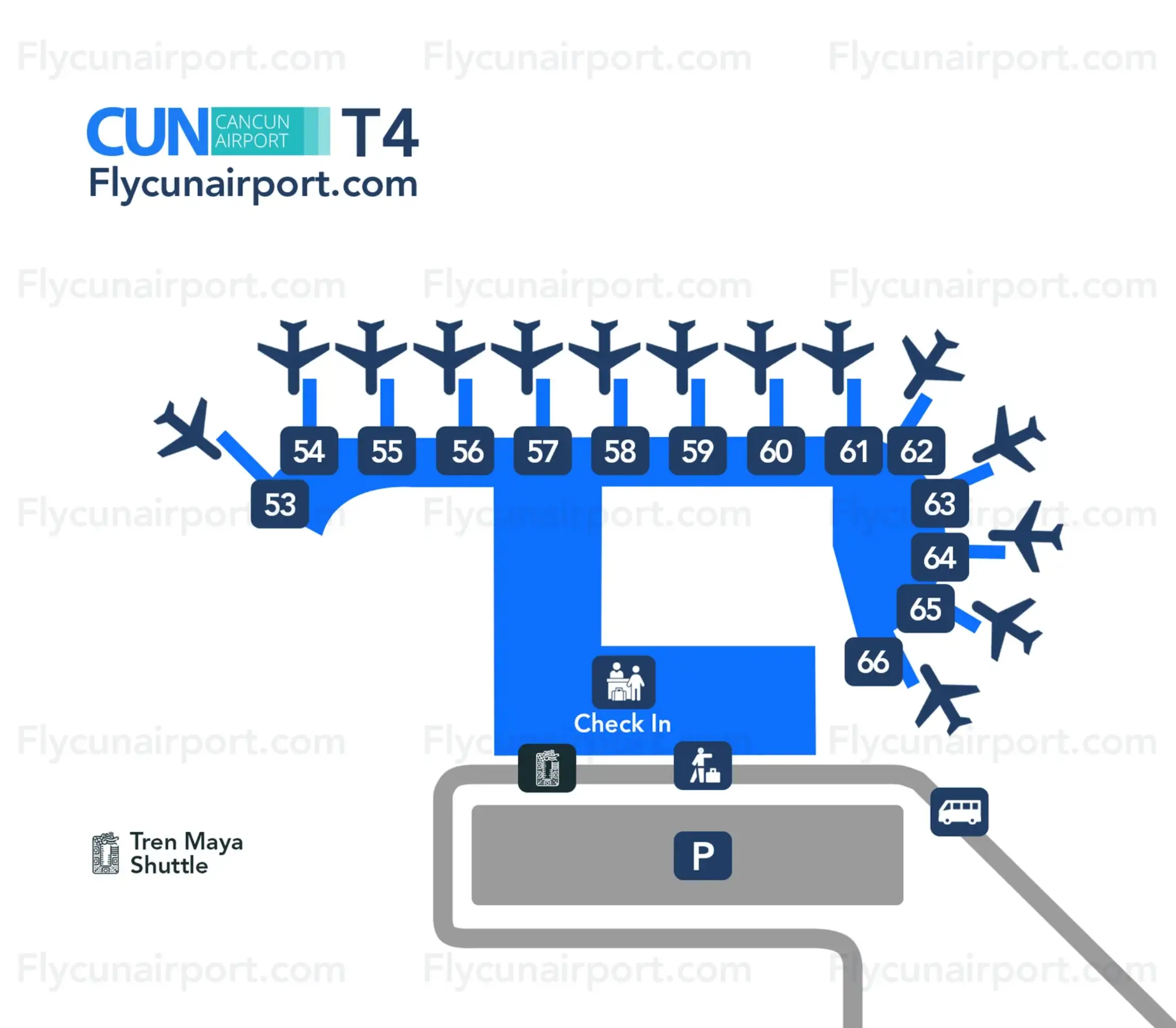
Cancún International Airport Terminal 4 Map (Most Up-To-Date)
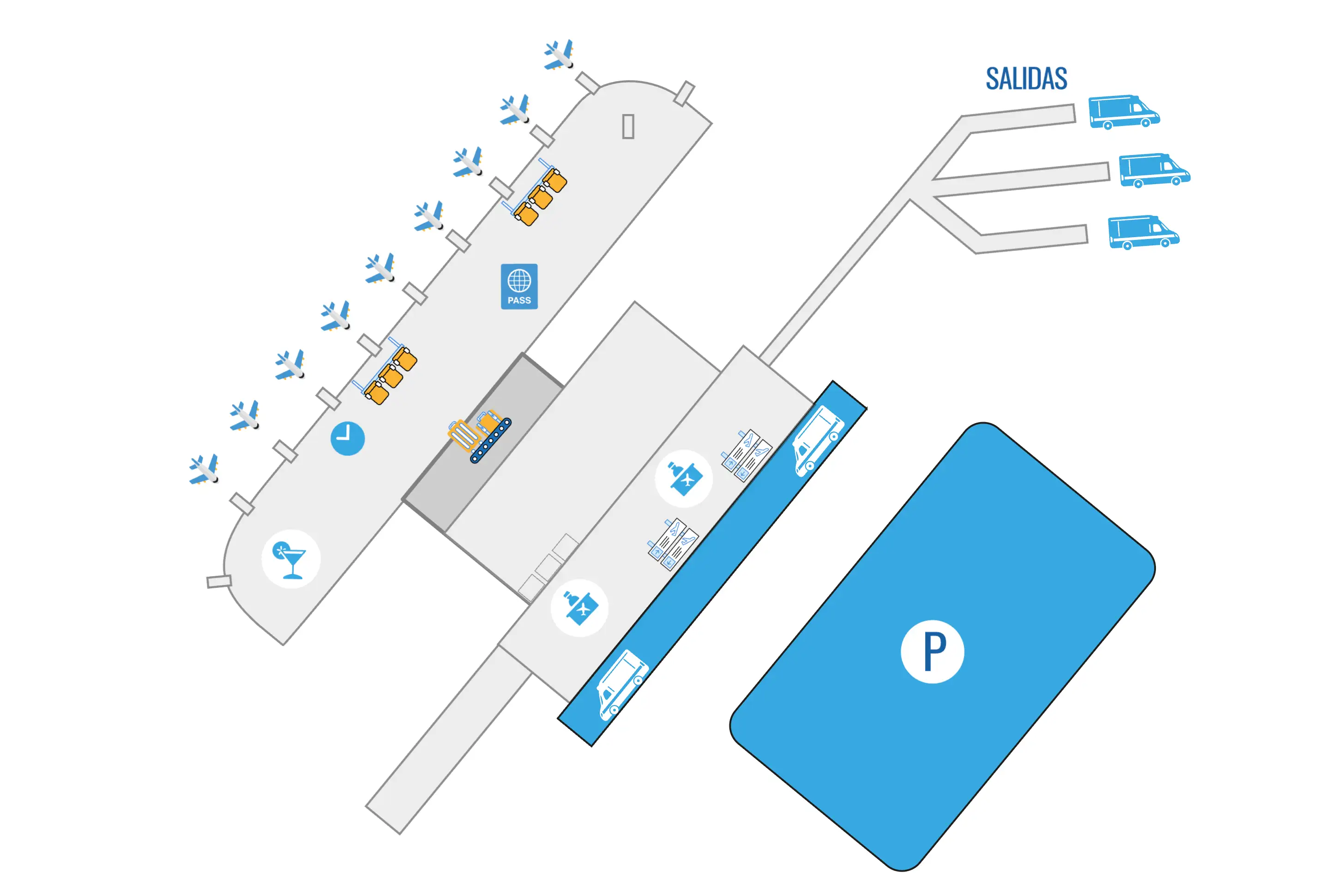
Cancún International Airport Terminal 4 (CUN T4) is a split-concourse terminal with a central atrium “hub” that feeds two long gate piers (D1–D12 and D13–D22). Arrivals descend from the gate level into a large ground-floor immigration hall, then flow through baggage claim and customs into a deliberately funnel-shaped exit corridor (“Shark Tank”) before reaching the curb. Within Cancún’s main airport hub, Terminal 4’s key navigation challenge is staying oriented after customs so you reach legitimate transport zones fast.
Map Table
| Concourse / Zone | Gates / Nodes | Primary Function | Ground Transport Interface |
|---|---|---|---|
| North Concourse | D1–D12 | Major US/Canada narrow-body flows | Central atrium → arrivals descent |
| South Concourse | D13–D22 | Wide-body Europe/seasonal charters | Central atrium → arrivals descent |
| Central Atrium | Duty-free exit, food court | Concourse split, airside services | Primary flow merge point |
| Arrivals Landside | Immigration, baggage, customs | Processing + reclaim | Shark Tank → curb |
Cancún International Airport Terminal 4 Map Strategy
- Use the immigration hall “left bias”: bank left off the descent escalators to reach the automated e-gates zone instead of joining the central manual queue ropes.
- Treat the customs sliding doors as the start of the trap: once the doors open, stay centered, keep walking, and aim only for the far-end exterior glass doors.
- Lock your transport plan before you exit: pre-booked transfers meet outside (not inside), and the ADO bus requires a right-turn sidewalk walk to the red kiosk/bus bays.
- Reduce walking surprises: assume a long pier walk to/from D1 or D22 and plan restroom/food stops in the central atrium before committing to the gate piers.
2026 Cancún International Airport Terminal 4 Map + Printable PDF
Operational flow in 2026 still hinges on three choke points: variable-capacity immigration, baggage belt latency, and the post-customs “Shark Tank” corridor that feeds you into curbside solicitation. Terminal 4’s geometry hasn’t changed: two long D-gate piers feed a single arrivals descent, and the true “exit” is beyond the final glass doors at the end of the corridor. Printing a Terminal 4 map helps you pre-commit to the correct doors and pickup zones before you land.
2026 Cancún International Airport Terminal 4 Map Guide
Where is the first decision point after customs in Terminal 4 where passengers can accidentally enter the transport-sales corridor, and what is the bypass route to the true exit doors?
The first decision point is the moment the customs sliding glass doors open, because you’re already being fed directly into the enclosed “Shark Tank” corridor with sales counters on both sides. The bypass route is simply committing to a straight, no-stops walk to the far-end exterior glass doors.
Customs exits into a hallway lined left and right with “information-style” counters where uniformed solicitors intercept people with questions like “Shuttle?” or “Confirmation?”. Stay on the corridor’s center line, keep your pace, and visually lock onto the final set of glass doors roughly 50–70 meters ahead. Legitimate pre-booked drivers are not allowed inside this corridor, so anyone claiming they’re your driver in this space is not your pickup.
What is the precise location of the official pre-booked shuttle/transfer meeting zone outside Terminal 4 (landmark + door number/side), relative to the main exit?
Drivers are not allowed inside the post-customs corridor, so the official pre-booked transfer interface starts outside, past the final exterior glass doors at the end of the “Shark Tank.” The meeting zone is the curbside greeter area commonly referenced as Platform C, anchored by the “Welcome Bar” / Margaritaville-style kiosk.
Exit through the far-end exterior doors, then ignore the first cluster of solicitors at the threshold and walk 50–80 meters along the covered curbside area toward the pre-booked transportation/greeters zone. Use the bar/kiosk as your fixed landmark, then look for a greeter holding a company-logo sign who radios the vehicle in from a holding lot. Avoid anyone offering to “find your driver” on the sidewalk.
What is the shortest mapped walking route from Terminal 4 arrivals to the official taxi/ride pickup area, and where are the pinch points where solicitors cluster?
The official taxi/ride pickup area sits on the inner curb immediately outside the Terminal 4 exterior exit doors, reached in about 20–40 meters of walking once you’re out of the final glass doors. The main pinch point is the automatic-door threshold where “pirate” solicitors try to intercept you before you reach the dispatch booths.
| Segment | Path cue | Distance | Pinch point risk |
|---|---|---|---|
| Customs exit → corridor end | Center-line through the “Shark Tank” to the far glass doors | ~70 m | Counter-side intercept attempts |
| Exterior doors → taxi booths | Step outside, angle toward the marked taxi dispatch booths on the inner curb | ~20–40 m | Highest density solicitation at the door threshold |
| Taxi booths → vehicle queue | Buy the fixed-rate ticket, then move into the assigned queue lane | ~10–30 m | Sidewalk “helpers” offering unofficial rides |
What is the exact walking distance (meters) from Terminal 4 customs exit doors to the ADO bus pickup point (including any outdoor segment)?
The walking distance from the Terminal 4 customs exit doors to the ADO bus pickup point is approximately 150–200 meters, including the outdoor sidewalk segment. The shortest route is a straight-through exit from customs, then a right turn outside toward the parking/bus-bay side where the red ADO kiosk and coach bays sit.
Customs exit doors put you into the “Shark Tank,” so your first job is to walk the corridor end-to-end (about 70 meters) to the final exterior glass doors. Once outside, turn right and continue along the curb/sidewalk toward the parking lot and coach bays, using the red ADO kiosk signage as the anchor point. The common failure is stopping with third-party “shuttle” hawkers who claim you must transfer elsewhere; Terminal 4 is a direct ADO stop, and the ADO coach is the large red bus at the bays.
What is the exact outdoor walking distance (meters) between Terminal 4 and Terminal 3, and where does the route begin/end (door identifiers)?
Walking between Terminal 4 and Terminal 3 is effectively a dealbreaker route because there is no safe, continuous pedestrian path and travelers are often stopped on the airport roads. The road distance is roughly 2,500–3,000 meters, but it’s not a practical or recommended “walking distance” with luggage.
| Option | Start point | End point | Distance | What to do instead |
|---|---|---|---|---|
| Attempted walk | Terminal 4 main curbside exit doors | Terminal 3 curbside arrivals frontage | ~2,500–3,000 m | Don’t attempt; use the free inter-terminal shuttle |
| Shuttle transfer | Terminal 4 ground-transport curb | Terminal 3 ground-transport curb | Road segment | Wait for the airport shuttle (typ. 20–30 min frequency) |
If you need a precise begin/end anchor, use the Terminal 4 exterior arrivals doors (the doors after the post-customs corridor) as the “start,” and the Terminal 3 arrivals curb frontage as the “end.” The failure mode is that the loop road shoulder isn’t a real sidewalk, heat exposure is severe, and enforcement regularly discourages pedestrians—so plan on the shuttle even for “short” connections.
What is the exact walking distance (meters) from the Terminal 4 immigration exit to the first baggage carousel (shortest passenger route)?
The walking distance from the Terminal 4 immigration exit to the first baggage carousel is approximately 50 meters on the shortest passenger route. The path is a straight-through transition buffer from the passport-control exit into the open baggage hall.
After you clear manual booths or the e-gates, you pass through the immigration exit turnstiles and enter a short connector area that often includes restrooms and signage screens. Continue forward and you spill directly into the baggage claim hall where the first carousels begin. The main failure mode here isn’t distance; it’s stopping in the narrow buffer and creating a people dam behind you, and relying on slow-updating carousel monitors—keep moving until you’re fully in the carousel zone, then stop and read the screens.
What is the exact walking distance (meters) from the first baggage carousel area to the true exterior exit doors, including the corridor turns that cause “false-exit” confusion?
The walking distance from the first baggage carousel area to the true exterior exit doors is approximately 150 meters, because the path includes customs, then the full length of the enclosed post-customs corridor before you reach the real curbside doors. The “false-exit” confusion happens when people mentally treat the solicitation corridor as the arrivals lobby.
From the first carousel, walk to customs (about 30 meters), clear the customs control point (another ~10 meters), and you’ll immediately meet the start of the “Shark Tank” corridor (around the 40-meter mark of the overall route). Traverse the corridor end-to-end (~70 meters) to the far-end exterior glass doors (around ~110 meters cumulative), then continue a short additional stretch to fully clear the doorway crowd and reach open curb space (~150 meters total). The most reliable anchor is the far glass doors at the corridor end—those are the true exit.
What is the precise location of automated passport control / e-gates within the Terminal 4 immigration hall (which side, relative to primary queue entry)?
Automated passport control e-gates are on the far left side of the Terminal 4 immigration hall relative to the primary manual-queue entry. The key move is banking left immediately at the bottom of the arrival escalators instead of flowing into the central rope maze.
Descend the central escalators from the arrivals level and ignore the main mass of passengers feeding into the middle/right manual lines. Turn left as soon as you hit the floor and look for the kiosk bank with overhead lane indicators (often green/red lights). The walking deviation is roughly 20 meters versus joining the central ropes, but the time savings can be substantial when staffing and heat-driven throughput slow the manual lines. If you need a passport stamp for a specific administrative reason, use manual processing instead.
What is the fastest mapped route from the furthest arrival gate in Terminal 4 to immigration queue entry, including any corridor merges that slow walking flow?
The fastest route from the furthest gates (D1 in the north pier or D22 in the south pier) to immigration queue entry is a straight pier walk to the central atrium merge, then continuing to the descent escalators into the immigration hall. The corridor merge at the central atrium “V” convergence is the main slow-flow point.
From D1 or D22, stay on the main concourse spine toward the center of the terminal until both piers funnel into the double-height central atrium. Expect “platooning” when multiple flights dump passengers at once, and expect a speed drop at the point where north and south flows merge into one stream. Continue straight to the escalators down to immigration; queue entry begins immediately after the descent at the rope-barrier head. Total worst-case walking distance is about 600 meters from the end gates to the immigration queue mouth, with the merge point being the main delay amplifier.
What is the walking distance (meters) from Terminal 4 security exit to the furthest gate cluster used by major carriers in T4 (worst-case gate sprint)?
The walking distance from the Terminal 4 security exit to the furthest gate clusters (near D1 on the north end or D22 on the south end) is approximately 550 meters. The forced-path duty-free maze immediately after security is the main reason the walk feels longer than the map distance.
| Route leg | Anchor point | Distance |
|---|---|---|
| Security exit → duty-free exit | Mandatory duty-free serpentine | ~100–150 m |
| Duty-free exit → central atrium | Opens into the central hub/food court | ~50–100 m |
| Central atrium → concourse split | Left to D1–D12, right to D13–D22 | ~50 m |
| Split → end gate cluster | Linear pier walk to D1 or D22 | ~250–350 m |
At a brisk pace with luggage drag, this is typically 10–12 minutes without moving walkways, and closer to 7–8 minutes if walkways are operating and the piers aren’t congested.
Inside Terminal 4 departures, where is the main departures information board used to confirm gate changes, and what is the walking time from the most common check-in area to that board?
The main departures information boards are in the central Terminal 4 check-in hall, positioned above and around the entrance to the security checkpoint. Walking time from the typical check-in rows to the board is about 1–2 minutes, even from the far end of the hall.
Most passengers encounter the primary FIDS screens while facing the security entrance after finishing at their airline counter, because the screens are mounted high and intended to be readable from across the hall. Use the security entrance as your anchor: the board is effectively “over the mouth” of the security queue area. The common failure mode at CUN is treating this as the only gate check; re-check the airside screens in the central atrium immediately after duty-free before committing to the long walk down the D-gate pier.
In Terminal 4, what is the maximum walking distance (meters) between the furthest pair of restrooms accessible post-security (worst-case scenario)?
The maximum post-security restroom gap in Terminal 4 is approximately 300–400 meters, between the central atrium restroom core and the restroom blocks at the far ends of the concourses near D1 (north end) or D22 (south end). The worst case happens when an end-pier restroom is closed for cleaning and you have to backtrack.
The most reliable anchor is the central atrium just after duty-free, where restroom access is comparatively predictable and higher-capacity. Once you commit to walking down a pier toward D1–D12 or D13–D22, restroom spacing becomes less frequent and more disruption-prone. The practical tactic is to use facilities in the atrium before the long pier walk, because a full backtrack from an end gate area to the atrium can add several hundred meters and multiple minutes.
Where is the highest-seat-density eating area in Terminal 4 airside, and what is the shortest route to it from the central concourse?
The highest-seat-density eating area in Terminal 4 airside is the central atrium food court area immediately after the post-security duty-free exit. The shortest route from the central concourse is effectively “follow the forced duty-free path until it releases you into the double-height atrium.”
From the security checkpoint, you’re routed through the duty-free maze and emerge into the central hub where the main food and retail cluster sits. Use the duty-free exit as your anchor: once you clear it, you are already at the atrium dining concentration, with seating spread around the hub circulation space. The trade-off is that this zone is the most crowded during peak bank times, so it’s the best target for guaranteed seating volume, not guaranteed quiet.
Where is the nearest quiet/low-traffic seating zone in Terminal 4 airside, and what is the walking distance from the central retail/food strip to that zone?
The nearest quiet seating zones are at the far ends of the gate piers, around the end-cap holding areas near D1/D2 on the north side or D21/D22 on the south side. The walking distance from the central atrium retail/food strip to those quieter end zones is approximately 300–400 meters.
Most passengers cluster in the central atrium around food and shops, so simply continuing down either pier thins the crowd quickly. Start from the atrium (right after duty-free), choose the correct direction at the concourse split, and keep walking until you’re near the end gates where there’s less through-traffic and fewer people loitering between shops. The practical trade-off is distance back to food and some gate-area seating turnover when boarding waves hit.
Archive Cancún International Airport Terminal 4 Map
Below are all historical map versions for Cancún International Airport. Each year includes the official map available for that period, presented as both WebP and PDF.
2024 Cancún International Airport Terminal 4 Map