Buffalo Niagara International Airport Map (Most Up-To-Date)
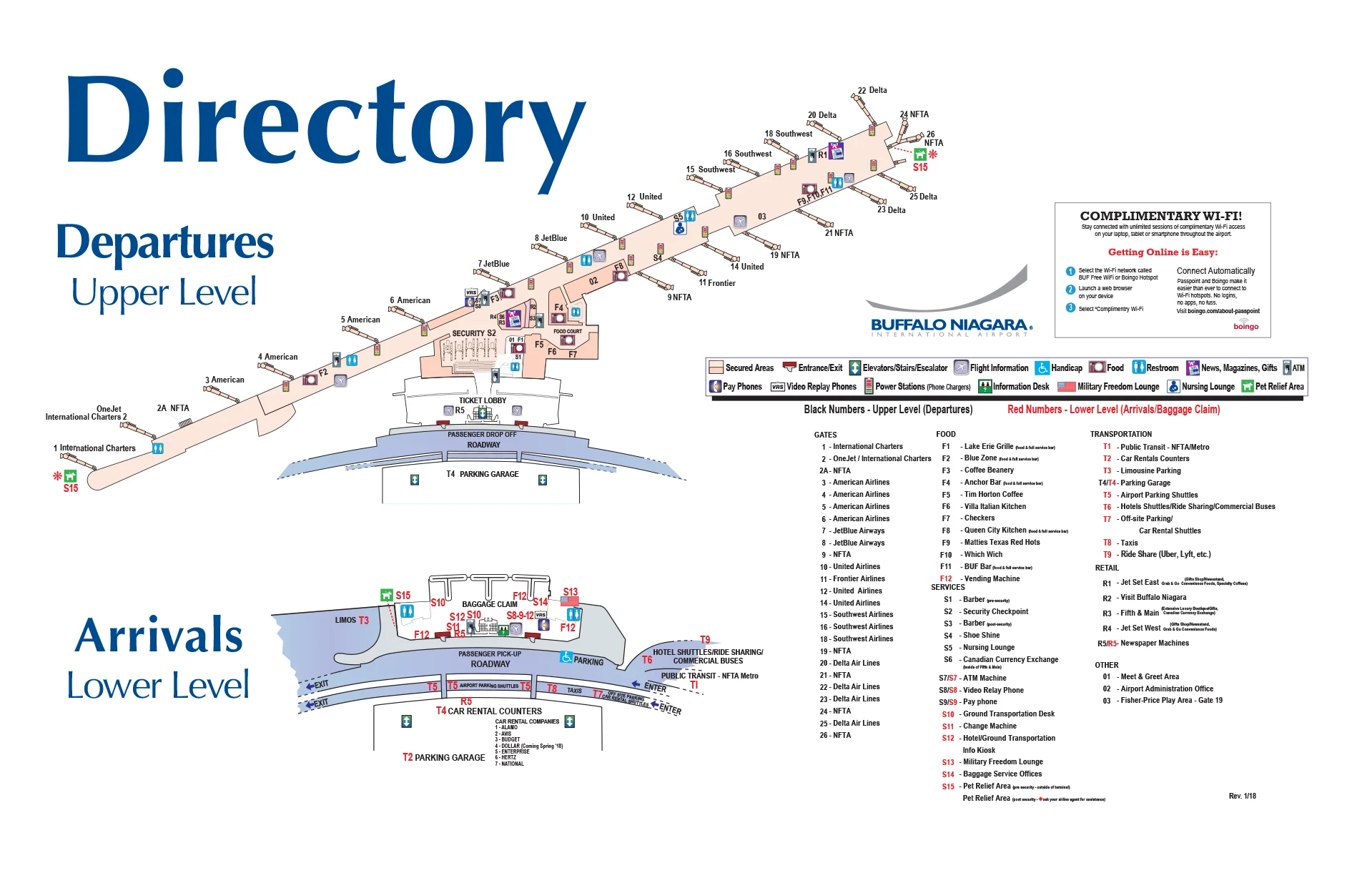
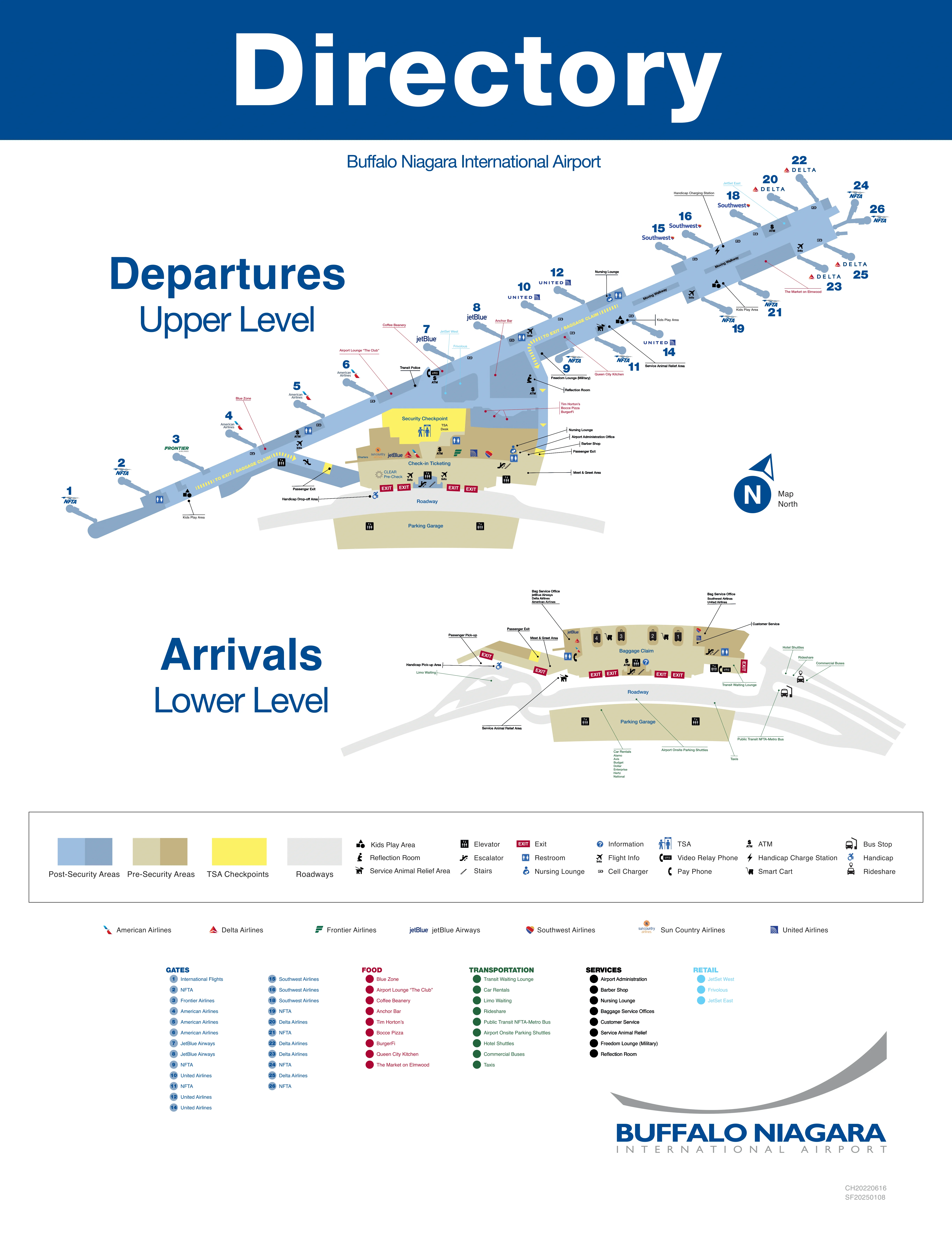
BUF is a single-terminal, dual-level building stretched along a long concourse that runs out from one central security node within Buffalo’s main airport hub. Departures (ticketing + TSA + gates) sit on the Upper Level; Arrivals (baggage claim + ground transport exits) sit on the Lower Level. The whole layout behaves like a “tube”: one choke point at the center, then a long walk to far gates—so your plan should start from the terminal core and work outward.
Map Table
| Terminal | Key Airlines | Primary Function | Transfer Mode |
|---|---|---|---|
| Single terminal, Upper Level | Southwest, Delta, United, JetBlue, American, Frontier | Ticketing, TSA, Gates 1–26 | Walk |
| Single terminal, Lower Level | Ground transport, rental car access | Baggage claim, pickups, exits | Walk, crosswalk |
| East concourse wing | Southwest-heavy, JetBlue, Delta, United | Gates 9–26 | Walk, moving walkways |
| West concourse wing | American, Frontier | Gates 1–8 | Walk |
Buffalo Niagara International Airport Map Strategy
- Build buffer around the single TSA checkpoint: treat security as the only true failure point, and plan your arrival time for line volatility, not “small-airport vibes.”
- Delete uncertainty between parking and ticketing: use the garage Level 2 enclosed bridge when time-critical, and memorize the indoor connector entry so weather and shuttles don’t set your schedule.
- Treat curbside pickup as a compliance zone: plan a staging option (cell phone lot or garage meet-up) so “no standing” enforcement and curb congestion can’t force laps.
- Navigate rideshare like a separate destination: go map-first to the ground transportation/rideshare area across the roadway and follow the signed walking route so you’re not stranded at the wrong door.
2026 Buffalo Niagara International Airport Map + Printable PDF
2026 travel at BUF still hinges on one central TSA checkpoint and a long east-wing concourse walk to the far gates, so the map matters most for time buffers and “where exactly do I go” decisions. Print the terminal layout to lock in the garage bridge entry, the rideshare/ground-transport crossing, and the curbside segments where stopping is restricted.
2026 Buffalo Niagara International Airport Map Guide
What is the exact walking distance (feet/meters) from the main TSA exit to the farthest commonly used gate cluster at BUF?
The walk from the TSA exit at BUF to the farthest commonly used gates at the east end (around Gate 26) is about 1,200–1,500 feet (365–450 meters).
The central TSA exit spills into the post-security atrium/food court area, which acts as the “zero point” for airside walking. From that node you turn right into the long East Wing (Gates 9–26) and continue to the distal end. At a brisk pace it’s roughly 4–6 minutes, but with carry-ons or crowds it commonly runs 8–12 minutes, especially if the moving walkway segments aren’t helping flow.
What is the shortest indoor route from the parking garage connector to the Departures check-in hall (name the connector/door/entry point shown on the map)?
The shortest indoor route is the Daily/Hourly Garage Level 2 enclosed pedestrian bridge that drops directly into the Upper Level ticketing/check-in hall.
Park in the Daily/Hourly Garage (Red signs) and go to Level 2, then walk to the central elevator/stair core and follow signs for the Enclosed Pedestrian Bridge. Cross the bridge and you enter the Departures/Ticketing Hall on the Upper Level, typically landing near the mid-terminal counter zone (between the west and east counter banks). This path avoids the Arrivals level entirely and keeps the full garage-to-check-in move weather-protected once you’re inside the structure.
Where is the exact rideshare pickup zone (Uber/Lyft) on the terminal map, and what door number / curb label is it tied to?
The rideshare pickup at BUF is in the Ground Transportation Center / designated rideshare lane across the Arrivals roadway, not on the main baggage-claim curb.
From Baggage Claim on the Lower Level, exit through any of the main doors (the numbered doors serve private pickup), then follow the green “Ride Sharing/Ground Transportation” signage to the marked pedestrian crosswalk. Cross the active Arrivals roadway into the ground-transport area by/within the parking structure frontage, where the Uber/Lyft loading lane is marked. The key dealbreaker is that this pickup is not tied to a specific terminal door number or “Door 1–4” curb label—waiting at a numbered door on the curb won’t match the geofenced rideshare lane.
Where is the remote/off-airport shuttle drop-off point on the Departures curb (which lane/door segment does it use)?
Remote and off-airport shuttles at BUF typically drop on the Upper Level Departures curb in the outer/commercial lane, using the mid-terminal curb zone along the Ticketing Hall.
On the Departures roadway, the shuttle path is designed to avoid the tight inner curb where private cars stack, so buses/vans use the outer lane / bus-friendly curb segment in front of the continuous ticketing façade. Practically, that means you want to get off near the center of the ticketing hall (the best “neutral” position for any airline counter) and enter through the nearest Departures doors into Ticketing, then walk laterally to your carrier’s counter and straight back to the central TSA node.
Where are the rental car counters located relative to Baggage Claim (same building vs separate facility), and what is the exact walking path shown on the map?
Rental car counters at BUF are in the parking garage’s ground-floor rental car center across from the terminal, not inside the Baggage Claim hall.
From Baggage Claim on the Lower Level, exit toward ground transportation, then use the marked pedestrian crosswalk to cross the Arrivals roadway into the garage frontage. Enter the garage/rental lobby on Level 1 (ground level) where the consolidated rental counters (e.g., Hertz/Avis/Enterprise group brands) sit. This is a walk-up connection—no rental shuttle is required—so the critical map feature is the crosswalk alignment between the terminal exit doors and the garage/rental entrance.
What is the exact walking path from Baggage Claim exit to the rideshare pickup walkway/exit (list the map landmarks: doors, corridors, turns)?
The walking path is Baggage Claim → terminal exit doors → crosswalk → Ground Transportation Center rideshare lane.
From the baggage carousels, walk toward the main public exit on the Lower Level and leave through the numbered baggage-claim doors (Doors 1–4 area). Step onto the Arrivals sidewalk, then turn toward the green “Ride Sharing/Ground Transportation” signs and follow them to the marked pedestrian crosswalk. Cross the Arrivals roadway to the opposite side into the ground transportation/transit plaza by the parking structure frontage. Continue straight into the designated rideshare loading lane, where Uber/Lyft pickups are staged and labeled in that commercial vehicle area rather than at the numbered terminal curb.
If curbside is congested, where is the cell phone lot located, and what is the fastest mapped driving route from the cell phone lot to the Arrivals pickup curb?
The cell phone lot is on Buell Avenue, just off Genesee Street across from the airport approach.
Exit the cell phone lot onto Buell Avenue, then turn onto Genesee Street toward the airport entrance. Follow the airport entry signs, enter the main loop, then take the split for Arrivals / Lower Level (keep left where the roadway divides from Departures). Stay on the Arrivals roadway to the pickup curb outside Baggage Claim doors, expecting the final merge to be the slowest point during peak arrival banks.
Where is the TSA checkpoint entrance relative to the main check-in counters (which side/door alignment), as shown on the terminal layout?
The TSA checkpoint entrance at BUF is mid-terminal on the Upper Level, set behind the central atrium zone and reachable by walking to the center of the ticketing hall from any airline counter bank.
The check-in counters run along the length of the Departures/Ticketing Hall, with carriers clustered east and west. After bag drop, the shortest move is to re-center yourself in the hall and walk toward the central security queue that divides the building into the West Wing (Gates 1–8) and East Wing (Gates 9–26). The practical alignment cue is that TSA is not “at an end”—it’s the central choke point you walk to from whichever set of counters you used.
If any moving walkway segments are out of service, what is the alternate pedestrian route shown on the map between the affected corridor endpoints?
There is no separate alternate corridor at BUF when a moving walkway segment is out of service; the route becomes the adjacent standard floor path in the same East Wing corridor.
The moving walkways sit within the main airside hallway leading from the post-TSA atrium toward the higher-numbered gates (East Wing). If a belt is down, you stay in that same corridor and continue on the parallel walking surface beside the walkway, passing the same storefronts/gate spurs and using the same straight-through alignment to the next corridor endpoint. The operational change is crowding—when the belt stops, all fast/slow traffic collapses into the floor lanes, so your time-to-gate becomes less predictable even though the physical path doesn’t change.
From the Orange Lot (or equivalent walkable economy lot), what is the exact pedestrian route to the terminal entrance (garage bridge vs open-air sidewalk), as shown on the map?
The Orange Lot pedestrian route is an open-air walk to the garage/terminal area first, then a garage-based connection—the enclosed bridge only helps after you reach the garage.
Exit the Orange Lot toward the main internal roadway/sidewalk edge and walk along the airport’s internal frontage toward the Daily/Hourly Garage. Use the safest marked pedestrian edges available to reach the garage side (this is the critical exposure zone in snow/wind). Once at the garage, enter on the ground level, go to the elevator/stair core, then go up to Level 2 and use the enclosed pedestrian bridge into the Upper Level ticketing hall. This is why Orange is a shuttle-first lot: the “nice” indoor connector is not a direct Orange-to-terminal tunnel—it’s a garage feature you access only after the outdoor trek.
Where are the most time-critical bottleneck pinch points shown on the landside map (single corridor/bridge/escalator bank) between parking/ground transport and Security?
The most time-critical landside pinch points at BUF are the garage connector/elevator core, the arrivals crosswalk conflict zone, and the single TSA checkpoint queue entrance.
| Pinch point | Where it happens | Why it spikes time-risk |
|---|---|---|
| TSA checkpoint entrance | Upper Level, mid-terminal | Single-node queue, no alternate checkpoint |
| Arrivals roadway crosswalk | Lower Level exits → garage/ground transport | Pedestrians stop vehicle flow; congestion feeds back into curb lanes |
| Garage elevator/core to Level 2 bridge | Daily/Hourly Garage → enclosed bridge | Elevator bunching during peaks; slows the “deterministic” garage route |
| Ticketing hall mid-zone | Upper Level counter banks | Bag-drop lines spill into walking path to TSA |
Archive Buffalo Niagara International Airport Map
Below are all historical map versions for Buffalo Niagara International Airport. Each year includes the official map available for that period, presented as both WebP and PDF.