Boise Air Terminal Map (Most Up-To-Date)
Boise Air Terminal/Gowen Field is a compact, two-level terminal with an east–west “Rotunda spine” at the center and a tight curb loop stacked by level: Departures on the upper roadway, Arrivals on the lower roadway. The airport’s functional footprint stretches west to the Economy Lot and the new cell phone staging area, making landside choices (lane + level + lot) the main success factor within Boise’s primary airport complex.
Map Table
| Terminal | Key Airlines | Primary Function | Transfer Mode |
|---|---|---|---|
| Main Terminal | Southwest, Delta, United, Alaska | Ticketing, TSA, baggage claim | Rotunda escalators/elevators |
| Upper Level | All airlines | Departures curb, rideshare pickup | Curbside sidewalk |
| Lower Level | All airlines | Arrivals curb, taxis, buses, shuttles | Crosswalk to median island |
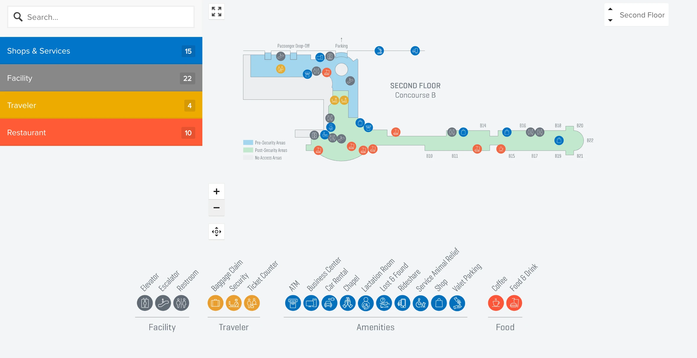
| Concourse A/B | All airlines | Gates | Post-security walk |
Boise Air Terminal Map Strategy
- Commit to your lot before you commit to the terminal loop: Economy Lot and cell phone staging are west-side decisions that are painful to “fix” after you’ve entered the Vista/Airport Way approach.
- Treat curb access as a level-choice problem: Arrivals functions on the lower roadway, while rideshare pickup operates on the upper curb near the Rotunda east end.
- Use curb color zones as your ground-transport cheat code: green for courtesy shuttles, black for taxis, purple for Valley Ride buses—on the lower-level median island.
- When lines spill, route by geometry, not intuition: use the Rotunda perimeter path (glass-side “flank”) to reach bag drop without walking into the TSA queue tail.
2026 Boise Air Terminal Map + Printable PDF
Boise Air Terminal/Gowen Field’s 2026 map needs to be landside-first: Economy Lot and the as-built cell phone staging location sit west of the terminal approach, and curb access splits by level (Arrivals vs Departures). Construction-era routing and peak-day demand make parking capacity, shuttle timing, and pickup staging the common failure points—so the most useful printable is the one that labels exact entrances, curb colors, and the Rotunda vertical core.
Boise Air Terminal Level 1 Map 2026
Boise Air Terminal Level 2 Map 2026
Boise Air Terminal Level 3 Map 2026
2026 Boise Air Terminal Map Guide
What is the exact driving route and turn-by-turn entry to the Economy Lot shuttle pickup (Orchard & Victory area), including the correct entrance to avoid circling?
The Economy Lot shuttle pickup is accessed from West Victory Road via the Orchard Street interchange, not from the main terminal loop off Vista Avenue. From Interstate 84, exit at Orchard Street (Exit 52), drive south to Victory Road, turn right (west), then enter the Economy Lot on the right side of Victory Road.
From I-84 (most reliable)
| Step | Road move | Landmark anchor |
|---|---|---|
| 1 | Take I-84 Exit 52 (Orchard Street) | Orchard St interchange |
| 2 | Turn south onto Orchard Street | overpass crossing I-84 |
| 3 | Continue to Victory Road | signalized Orchard & Victory |
| 4 | Turn right (west) on Victory Road | moving away from terminal |
| 5 | Enter Economy Lot on the right (north) side | fenced surface lot, airport signs |
If you already committed to Vista/Airport Way (save route, no circling)
| Step | Road move | Landmark anchor |
|---|---|---|
| 1 | Exit back out to Vista Avenue northbound | before garage intake lanes |
| 2 | Turn left (west) onto Wright Street | frontage-style connector |
| 3 | Continue west past Orchard Street | Wright transitions into Victory |
| 4 | Continue on Victory to the Economy Lot entrance (right) | same fenced lot entry |
What is the exact walking distance (in feet/meters) from the Economy Lot shuttle drop-off point to the TSA checkpoint entrance?
Walking from the Economy Lot shuttle drop-off (the green curb on the lower-level median) to the TSA checkpoint entrance is about 350–450 feet (roughly 100–140 meters). The distance includes a short crosswalk from the median to the terminal doors, then an interior walk to the Rotunda escalators, the vertical ride up, and a final traverse across the upper Rotunda to the checkpoint.
| Segment | Anchor point to anchor point | Distance |
|---|---|---|
| 1 | Green curb median → terminal crosswalk/doors | ~60 ft (~18 m) |
| 2 | Entry doors → Rotunda escalator base | ~100–150 ft (~30–46 m) |
| 3 | Escalator/elevator up → upper Rotunda floor | vertical transition |
| 4 | Upper Rotunda landing → TSA entrance | ~150–200 ft (~46–61 m) |
| Total (walk only, excluding vertical rise) | ~350–450 ft (~100–140 m) |
Where are the overflow parking areas west of the airport (the ‘mile or two’ overflow), and what is the shortest mapped path from overflow lot → terminal curb?
Overflow parking west of Boise Air Terminal/Gowen Field is functionally the Economy Lot at Victory Road and Orchard Street for nearly all peak periods. The “mile or two west” overflow only appears during surge events as temporary industrial-area lots near the Gowen Road corridor by Western Aircraft, and those are shuttle-dependent rather than walkable.
| Overflow type | Location anchor | Shortest path to terminal curb |
|---|---|---|
| Primary overflow | Economy Lot, Victory Rd & Orchard St | Orchard/Victory → shuttle to green curb (lower level median) |
| Surge overflow (event-activated) | Industrial lots near Western Aircraft, Gowen Rd corridor | Shuttle (if activated) or drive Gowen Rd east → Vista Ave north → Airport Way loop → Arrivals curb |
Walking from the Gowen Road / Western Aircraft area to the terminal curb is not viable as a practical route because it is over a mile and runs through industrial/airfield-edge roads without continuous pedestrian infrastructure; treat any west-side surge overflow as a shuttle workflow unless airport staff signage directs otherwise.
Where is the current cell phone waiting area / staging location (as-built right now), and what is the exact loop route to re-enter Arrivals without getting trapped in the backup?
The current cell phone waiting area is at 2950 South Curtis Road, west of the terminal and near the Victory Road corridor. The clean re-entry to Arrivals uses Curtis → Victory → Wright → Vista, then follows Arrivals signs to the lower-level loop.
| Step | Road move | Landmark anchor |
|---|---|---|
| 1 | Exit the cell phone lot, turn left (north) onto South Curtis Road | lot driveway to Curtis |
| 2 | Turn left (east) onto West Victory Road | signal at Curtis & Victory |
| 3 | Continue east through South Orchard Street | signal at Orchard & Victory |
| 4 | Stay straight as Victory becomes Wright Street | roadway name transition after Orchard |
| 5 | At Vista Avenue, turn right (south) | Wright St terminus at Vista |
| 6 | Follow Airport Way loop signs for Arrivals / Lower Level | split to lower roadway |
What is the exact point on the roadway where the cell-phone-lane backup begins (the choke), and what alternate nearby pull-off lots are within a 2-minute mapped drive?
The cell-phone-lane backup typically begins at the Vista Avenue off-ramp merge where traffic commits into the Airport Way loop and splits between Departures (upper) and Arrivals (lower). That split is the choke because hesitation and lane changes ripple backward onto the Vista approach and overpass.
| Alternate pull-off | Location anchor | Approx. drive to terminal |
|---|---|---|
| Chevron by the airport approach | Vista Avenue & Airport Way | ~0–1 minute |
| Hotels on Airport Way | Best Western Vista Inn area | ~1–2 minutes |
| Hotels on Airport Way | Comfort Inn & Suites area | ~1–2 minutes |
| Commercial lots north of Wright Street | Vista Avenue near Wright St | ~2–3 minutes (edge case) |
These alternates are unofficial staging spots with property enforcement risk; the only sanctioned free waiting zone remains the cell phone lot on South Curtis Road.
Where is the official taxi pickup location at Boise Air Terminal/Gowen Field (exact curb/door), and what is the shortest indoor walking route from the main terminal exit to that point?
Taxi pickup is at the black curb on the lower-level median island outside baggage claim, reached by exiting the sliding doors by the baggage claim carousels and crossing the marked crosswalk to the island. The key visual anchor is the black-painted curb segment with taxi stand signage on the median between the inner curb lane and the commercial lane.
- Start at the baggage claim carousel area on the lower level.
- Exit through the sliding doors immediately adjacent to the carousels.
- Cross the marked crosswalk over the inner roadway lane to the median island.
- Stop at the black curb taxi stand zone on the island, aligned with the baggage claim exit doors.
Where is the rideshare (Uber/Lyft) pickup zone (exact curb/door), and what is the shortest indoor walking route from baggage claim to that zone?
Rideshare pickup is on the upper-level curb at the east end, accessed from the second-floor Rotunda exit doors rather than the lower baggage-claim curb. The dealbreaker is that Uber/Lyft pickup is geofenced to the upper curb, so exiting outside at baggage claim puts you on the wrong level.
- Start at baggage claim on the lower level.
- Go to the central Rotunda escalators/elevators and ride up to the second-floor ticketing/Rotunda level.
- At the top, turn right (east) to the Rotunda exit doors on the east side.
- Exit to the upper curb, then turn right along the sidewalk to the east-end rideshare shelters marked for Uber/Lyft.
What is the exact pedestrian route from the employee/remote parking side (or shuttle-stop area) into the terminal, including where sidewalks begin/end and crosswalk points?
The employee/remote parking pedestrian route uses the sidewalk network along Rickenbacker Street and Wright Street, then a designated protected crossing that feeds into the terminal-side entrances near the east garage/rental car side. Sidewalk continuity is strongest on the employee/garage side and becomes channelized at the marked crossing where pedestrian flow intersects garage intake traffic.
- Begin on the employee/remote parking side near the employee garage by Wright Street and Rickenbacker Street.
- Follow the concrete sidewalk along Rickenbacker Street to connect onto the Wright Street sidewalk segment.
- Use the signed, designated protected crosswalk that carries pedestrians across the active garage intake/roadway conflict zone toward the terminal complex.
- Enter via the ground-level east-side entrance near the rental car counters, or use the east garage vertical core to reach the terminal connection level if you’re routing to the Rotunda.
Where is the Valley Ride bus stop relative to the terminal doors, and what is the exact walking distance from that stop to airline check-in?
The Valley Ride bus stop is at the purple curb on the lower-level median island outside baggage claim, reached by crossing from the terminal doors to the island. Walking from that bus stop to airline check-in is about 300 feet plus the vertical transition up to the second-floor ticketing lobby.
- From the purple curb on the median, cross the marked crosswalk to the baggage-claim level doors.
- Enter the lower-level lobby, then go to the central Rotunda escalators/elevators.
- Ride up to the second-floor Rotunda/ticketing level.
- Walk from the Rotunda core to the airline ticket counters on the west side of the upper lobby.
From the parking garage pedestrian exit, what is the shortest mapped indoor/outdoor path to airline bag drop—specifically the route that avoids backtracking through the curbside pinch?
The shortest path from the parking garage to airline bag drop is the Level 2 skybridge straight into the second-floor Rotunda, then a short left/west walk to the ticket counters. This route avoids the curbside pinch entirely by staying above the roadway and bypassing the lower-level loop.
- From the garage, go to Level 2 and follow signs to the terminal skybridge.
- Cross the enclosed skybridge into the terminal Rotunda on the second-floor level.
- After the bridge enters the Rotunda, continue left/west toward the airline ticket counters.
- Approach your carrier’s bag drop from the Rotunda side rather than descending to the curb and re-entering.
On the terminal map, where do bag-check lines physically spill during peak days (which counters are closest to the main queue path), and what is the alternate approach path from entry doors?
Bag-check and TSA queues spill into the second-floor Rotunda and can block the east–west walking line between the skybridge entry and the central checkpoint. The counters most affected are the high-volume carriers—Southwest, United, and Delta—because their bag-drop queues extend perpendicular to the counters into the Rotunda flow space.
- The TSA line typically backs up from the central checkpoint into the Rotunda, sometimes reaching toward the skybridge entry.
- Bag-drop lines for Southwest, United, and Delta commonly project outward into the same Rotunda “spine,” cutting across the direct path to other counters.
- Use the perimeter “flank” path: from entry doors or the skybridge, move to the outer glass wall edge first, then walk along that clear perimeter to reach your specific counter from the side instead of pushing through the Rotunda center.