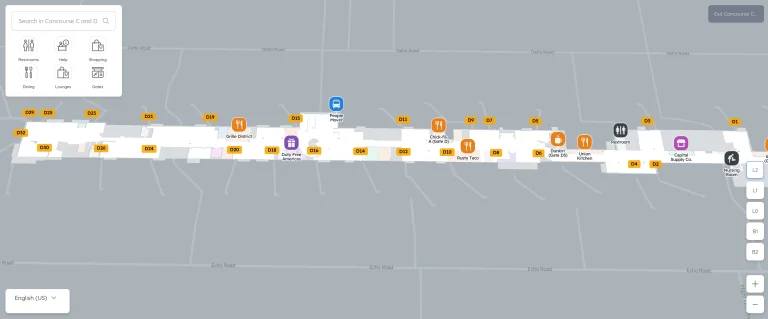
Boeing Field King County International Airport Terminal Map (2025-2024)
Use this Boeing Field King County International Airport Terminal Map to find gates, check-in areas, and transport links at one of Seattle’s most historic airfields.
King County International Airport (BFI) mainly handles general aviation, charters, and cargo operations, which is why passenger facilities are compact and easy to navigate. Look for “Departures” and “Arrivals” signs on the single main terminal level for orientation.
The Boeing Field King County International Airport Terminal Map highlights flight gates, passenger lounges, and ground transport zones so you can plan transfers or pickups with ease.
Because most commercial activity centers around one building, walking routes are short and signage is clear.
Boeing Field King County International Airport Terminal Map 2025-2024
Printable Boeing Field King County International Airport Terminal Map PDF 2025-2024
FAQ
What is King County International Airport used for?
King County International Airport (BFI), also known as Boeing Field, is used for general aviation, cargo operations, corporate flights, military operations, and aircraft testing. It also serves as a hub for Boeing aircraft deliveries and modifications.
Why is it called a Boeing Field?
The airport is called Boeing Field because Boeing has historically used it for aircraft manufacturing, testing, and deliveries. The company has maintained a strong presence at the airport since its early years.
What does Boeing do at BFI?
Boeing conducts aircraft testing, deliveries, and maintenance at Boeing Field. The company also uses the airport for customer demonstrations and modifications before aircraft are handed over to airlines.
What airlines fly out of Boeing Field?
Boeing Field primarily serves charter and private flights. JSX operates scheduled passenger service, while UPS and other cargo carriers use the airport for freight operations.