Bill and Hillary Clinton National Airport Map (Most Up-To-Date)
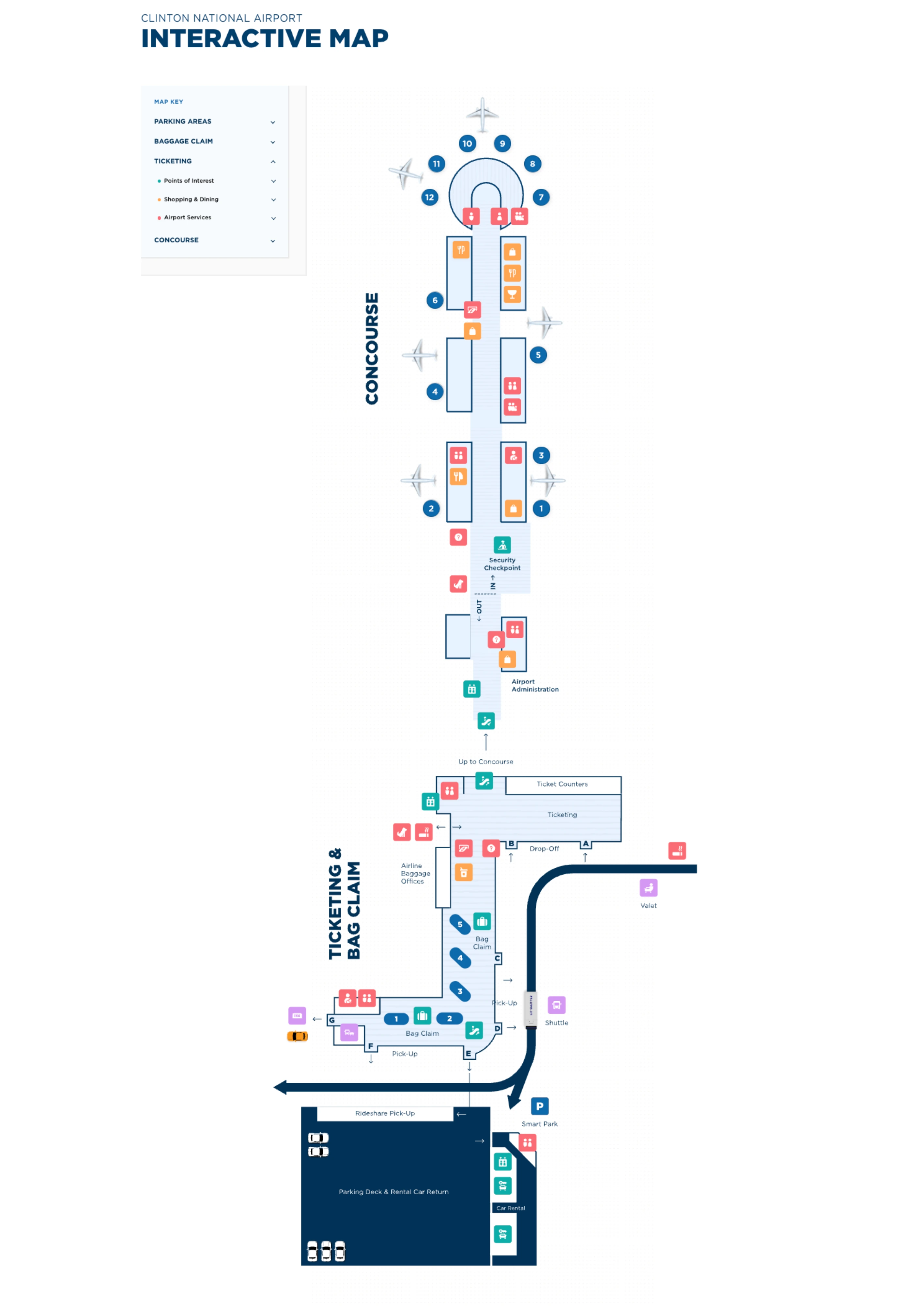
Bill & Hillary Clinton National Airport is a compact, single-terminal layout with a two-level landside core (baggage/arrivals below, ticketing/security above) feeding one linear concourse that ends in a rotunda for the far gates. Most movement is straight-line: parking/curbside → central escalators/skybridge → second-floor checkpoint → gates 1–12. Within the Little Rock air-travel hub, wayfinding hinges on door-letter exits and the centralized security bottleneck.
Map Table
| Terminal | Key Airlines | Primary Function | Transfer Mode |
|---|---|---|---|
| Single terminal | American, Delta, Southwest, United, Allegiant | Central security → single concourse gates 1–12 | Walk-only, curbside doors D/F/H, parking deck crosswalk |
Bill and Hillary Clinton National Airport Map Strategy
- Treat the second-floor security stanchions as the “anchor point,” then use the map to spot where the queue tail forms and where it backfills toward the escalator landing during the 4:00–6:00 AM surge.
- Assume expedited screening handling can change by hour; use the map to locate the parallel lane at the main checkpoint, then plan your arrival time as if you may be merged into the standard line.
- Choose parking by “shuttle/no-shuttle” first, then by walking exposure; West Economy is a walk commitment, while the Terminal Garage’s skybridge is the safest weather-protected entry.
- For arrivals, pick the correct lower-level exit door on the map before you walk: Door D for off-airport shuttles, Door F for Uber/Lyft and rental cars at the parking deck, Door H for taxis.
2026 Bill and Hillary Clinton National Airport Map + Printable PDF
Current airport operations still run through one centralized second-floor Transportation Security Administration checkpoint and a single concourse footprint, so the most useful printable map is the one that labels vertical circulation, the checkpoint frontage, and the lower-level door letters for pickups. Ongoing improvements like parking technology and roadway signage updates make door/lot precision even more important for curbside and deck routing in 2026.
2026 Bill and Hillary Clinton National Airport Map Guide
What is the exact point inside LIT where the TSA queue begins during early-morning rush (by the escalator, lobby center, or check-in row)?
The TSA queue begins at the second-floor stanchions directly in front of the main checkpoint entrance, facing the central ticketing lobby near the concourse entry. During the early-morning surge, the “start” is still the checkpoint mouth, but the practical join point is the visible tail of the stanchioned line extending into the open lobby.
The checkpoint sits in the geometric center of the second-floor public area, just beyond the top landing of the central escalators/elevators and across the open floor from the check-in counter rows. If you step off the escalator and see a line already occupying the escalator landing, that line is the security queue tail—join there rather than walking toward counters to “look for TSA.”
Where does the TSA line physically spill to when it’s “backed up” (which landmark does it reach first: escalators, ticketing counters, or entrance doors)?
The TSA line spills back into the second-floor central lobby and reaches the top landing of the central escalators and elevators first. When volume keeps building, it then expands laterally enough to intersect the ticketing counter rows in the same open lobby footprint.
In practice, the escalator landing is the clearest “overcapacity” landmark: if you come up from the lower level and the crowd is already stacked at the escalator/elevator landing, that is the end of the security line. When it grows beyond that point, the tail can wrap and blur into the check-in area, making it easy to confuse TSA overflow with airline counter queues unless you follow the stanchion direction back toward the checkpoint mouth.
Where is the dedicated TSA PreCheck lane physically located relative to the main checkpoint entrance at LIT?
The dedicated TSA PreCheck lane is positioned at the main second-floor security checkpoint alongside the standard screening entrance, running parallel to the regular lane. When it is operating as a distinct lane, it is accessed at the same checkpoint frontage rather than from a separate area of the terminal.
On the second floor, orient from the central escalators toward the checkpoint mouth at the concourse entry: the PreCheck position is integrated there, not upstairs or elsewhere. The third-floor PreCheck enrollment office is above the checkpoint but is only for applications, not day-of-flight screening. Because lane operation can vary by staffing and hour, the reliable “map move” is to walk to the checkpoint frontage and look for the PreCheck identifiers at the parallel lane before committing to the longer stanchioned queue.
What is the exact walking distance (feet/meters) from West Economy parking to the terminal entrance using the marked pedestrian route?
No shuttle service exists for West Economy at Bill & Hillary Clinton National Airport, so the “marked route” functions as a full surface walk to the terminal entrance. Exact feet/meters are not published in the available airport parking diagrams and wayfinding documentation for that lot-to-door path.
West Economy is best treated as a distance-variable, weather-exposed walk: plan extra time, expect curb/road crossings, and avoid it if you’re carrying heavy bags or arriving for the 4:00–6:00 AM security surge. If you need a predictable transfer, East Economy is the economy option that provides shuttle service, while the Terminal Garage plus skybridge is the most controlled, direct terminal entry.
Where does the Terminal Garage skybridge connect into the terminal (which doorway/corridor does it deliver you into)?
The Terminal Garage skybridge delivers you directly into the upper-level terminal interior at the ticketing/security level rather than the lower-level baggage claim curb. The connection is intended to bypass the multi-lane terminal roadway and place you into the second-floor public lobby zone that feeds check-in counters and the centralized security checkpoint.
From the garage, use elevators/stairs to the skybridge level, cross the enclosed bridge, and you arrive inside the main upper lobby within a short, straight walk of the central escalator landing and the TSA checkpoint frontage. If you find yourself descending to street level to cross traffic, you’ve missed the protected flow the skybridge is designed for—backtrack to the enclosed bridge entry instead of attempting an at-grade roadway crossing.
Which exact curbside door/zone is designated for off-airport parking shuttles to pick up arriving passengers outside baggage claim (e.g., Door letters)?
Off-airport parking shuttles and many hotel shuttles pick up at Exit Door D on the lower-level baggage claim curb. This door is aligned with the commercial shuttle operating zone, so it’s the best “door-letter target” to avoid missing a shuttle cycle.
Inside baggage claim, move toward the east side of the hall near Carousel 3, then exit through Door D and use the adjacent crosswalk to reach the covered shuttle pickup area on the commercial curb. If you exit Door F (rideshare/rental cars) or Door H (taxis), you’ll be outside the shuttle zone and may not see your shuttle when it arrives, forcing a long curbside walk or a re-entry to relocate to Door D.
Where is the exact Uber/Lyft pickup point at LIT relative to baggage claim exits (door label + curbside side)?
Uber and Lyft pickups use Exit Door F and occur across the crosswalk at the Parking Deck staging area. The pickup zone is not at the standard baggage-claim curb flow; it is positioned by the entrance to the parking deck where rideshare vehicles are geofenced to load.
From baggage claim, follow signs toward Rental Cars, exit through Door F, then cross the marked pedestrian crosswalk to the designated pickup lanes beside the parking deck. If you exit at Doors A–D (shuttles/other curb activity) or Door H (taxis), you will be on the wrong curbside segment and rideshare drivers typically cannot legally or digitally complete pickup there, which triggers delays, cancellations, or a forced walk along the outside curb to relocate back to Door F.
What is the exact walking distance from the TSA exit to the farthest gate in the concourse (end-to-end time/distance)?
Exact feet/meters from the TSA exit to the farthest gate are not specified in the available published architectural schematics for Bill & Hillary Clinton National Airport. The functional end-to-end route is a straight walk: TSA exit opens directly onto the main concourse spine, and the farthest gates sit at the end in the rotunda (typically Gate 12 area).
From the checkpoint exit, walk forward down the central concourse corridor past the first gate bank and concessions, then continue until the corridor terminates in the circular rotunda where the last gates cluster. The most reliable time-control move is to start walking as soon as you clear security if your gate is in the rotunda; food/retail immediately after TSA can create the only meaningful delay in an otherwise compact, single-concourse layout.
Where are the rental car counters located relative to the main entrance, and what is the shortest indoor path from baggage claim to those counters?
The rental car counters are on the ground level of the Parking Deck, not inside the main terminal footprint. The shortest path from baggage claim is to walk toward the Rental Cars wayfinding, exit the building at Exit Door F, cross the marked crosswalk, and enter the Parking Deck at ground level where the counters are stationed.
Inside the lower-level baggage claim hall, stay oriented toward the Door F exit corridor rather than following curbside doors for shuttles or taxis. Door F is the same “decision door” used for Uber/Lyft pickup, which is a helpful landmark if you’re unsure you’re headed the right way. If you look for counters in the ticketing lobby upstairs or along the baggage claim walls, you’ll hit a dead end and then have to backtrack to Door F.
Which check-in counter row is closest to the TSA checkpoint entrance (shortest walking path from airline counter to the queue start)?
The closest check-in counters are the second-floor ticketing counters clustered in the central lobby directly adjacent to the main TSA checkpoint frontage. Because ticketing and the checkpoint share the same open second-floor footprint, the “shortest” row is effectively whichever counter position is nearest the central escalator landing and faces the security stanchions toward the concourse entry.
In the morning surge, the practical limiter is not the counter-to-checkpoint walk but the way the TSA line can backfill into the same space and intersect ticketing queues. The fastest path is to finish bag drop at the counter position closest to the checkpoint mouth, then immediately angle toward the stanchions; if the queue tail has reached the escalator landing or wrapped near counters, join the tail where you see it rather than trying to walk “up” to the checkpoint entrance through the crowd.