Barcelona-El Prat Airport Map (Most Up-To-Date)
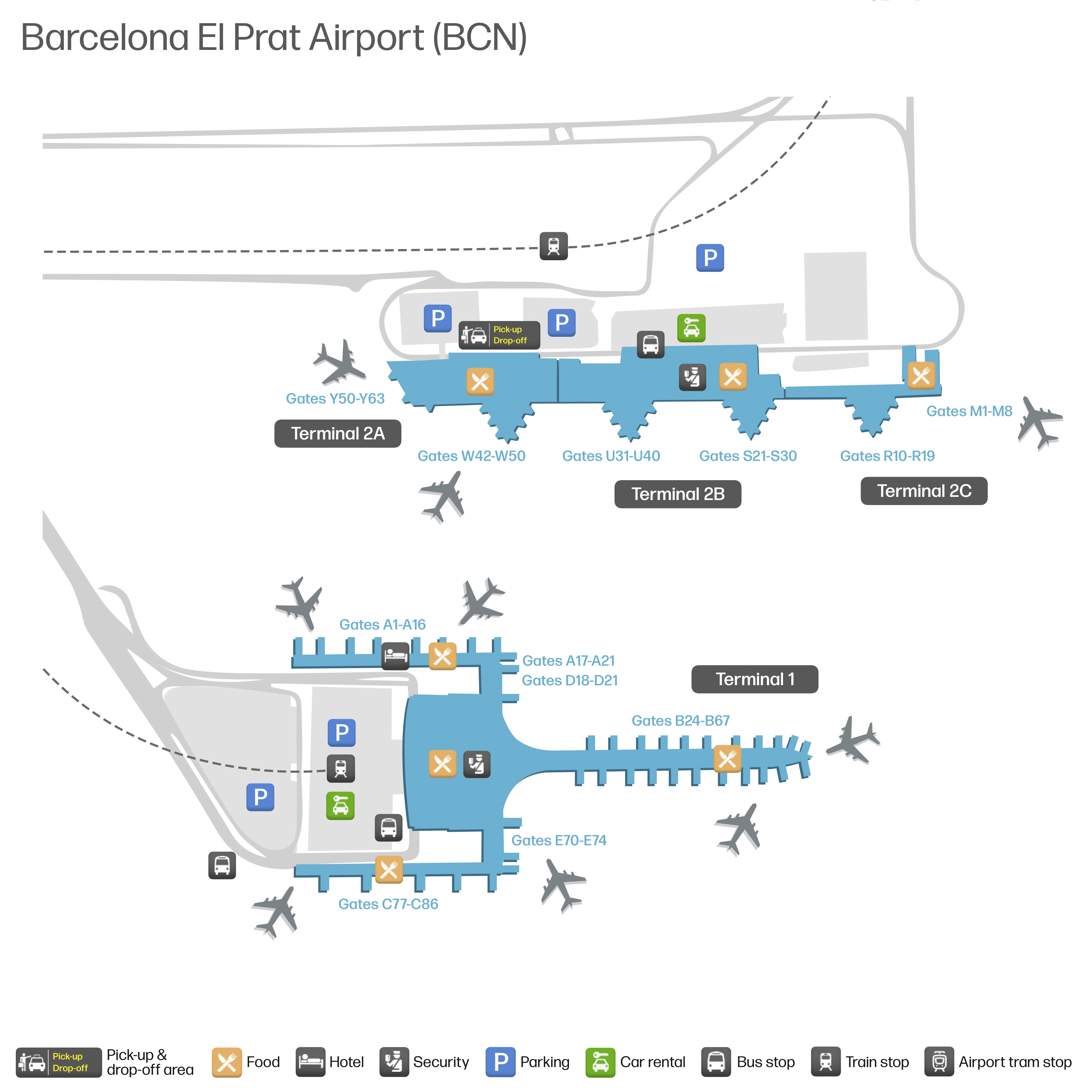
Barcelona’s main BCN hub operates like two separated campuses: the large, “sword-shaped” Terminal 1 (T1) and the long, modular Terminal 2 (T2A/T2B/T2C) about 4 km apart. The overall footprint is wide and road-oriented, with passenger movement defined by landside curb levels, bus decks, and a bridge-to-rail connection at T2B rather than any internal people-mover. Transfers depend on surface shuttles and clear floor/exit choices.
Map Table
| Terminal | Key Airlines | Primary Function | Transfer Mode |
|---|---|---|---|
| Terminal 1 | major network carriers, alliance traffic | main hub, long-haul, higher volume | free green shuttle to T2, taxi, Aerobús A1, Metro L9 |
| T2A/T2B/T2C | low-cost focus; T2C EasyJet | legacy linear complex, rail access | free green shuttle to T1, Rodalies bridge at T2B, Aerobús A2 |
Barcelona-El Prat Airport Map Strategy
- Treat T1 and T2 as separate airports: terminal mistakes are 30–45 minutes once you include curb walks, shuttle waits, and re-clearing security.
- Anchor every ground-transport move off a physical landmark: in T1 Arrivals, use the Go Natural café to choose the correct side before you commit to the wrong curb.
- Budget non-Schengen as a hidden extra checkpoint: passport control sits between “shopping feels like you’re done” and the D/E gate zones, with queues that can spill into vertical circulation areas.
- Assume T1 long walks are real: far gate zones (especially the E pier) can add a 15–30 minute post-security trek, and there are no “shortcut” myths that bypass the D/E passport-control barrier.
2026 Barcelona-El Prat Airport Map + Printable PDF
2026 navigation still hinges on two hard constraints: no walkable T1↔T2 link and no airside transfer between terminals. Expect all terminal changes to be landside with a shuttle + re-screening. T1’s vertical layout concentrates ground transport decisions on Arrivals Level 0, while non-Schengen processing can bottleneck on the Departures-level passport control before D/E gates.
2026 AIRPORT Map Guide
What is the exact indoor path and walking distance from T1 Arrivals to the free inter-terminal shuttle bus stop (including floor/exit used)?
The free inter-terminal shuttle stop is reached from T1 Arrivals (Level 0) by using the Go Natural café as the decision anchor, then exiting to the bus/shuttle curb on the lower roadway deck rather than the main pickup curb. From the public Arrivals Hall (La Plaza), the shortest “map-true” path typically takes about 4–7 minutes of walking plus a short vertical descent.
From baggage claim, enter the public Arrivals Hall on Level 0 and orient to the Go Natural café in the center of the flow. Keep Go Natural on your left shoulder and move to the right-hand side of the hall toward the ground-transport access, then take the ramp/escalator bank down to the lower curbside bus deck (the level used by Aerobús and the terminal shuttle). Exit onto that bus deck and follow the “Shuttle / T2” markings along the curb to the green shuttle stop area.
Where is the T1→T2 shuttle drop-off point at T2, and what is the exact walking distance from that drop-off to T2 Departures check-in?
The T1→T2 shuttle drops at the central bus stop under the roadway bridge by Terminal 2B, the same zone used for the train/metro access corridor. Walking to the closest T2 Departures check-in area (T2B) is a short, straight indoor move once you enter the T2B frontage.
| From shuttle drop-off (under-bridge stop at T2B) | Route using map landmarks | Walk distance | Typical walk time |
|---|---|---|---|
| T2B Departures check-in | Enter T2B via the main doors closest to the under-bridge stop, then continue into the central check-in hall | ~150–250 m | ~2–4 min |
| T2C Departures check-in (EasyJet module) | Follow the signed landside pedestrian path from T2B toward T2C along the external covered walkway/service-road edge, then enter T2C doors | ~300–500 m | ~5–8 min |
What is the precise map location of the non-Schengen passport control queue area in T1, and which landmarks does the line typically extend past?
Passport control for T1 non-Schengen departures sits on Level 3 in the D/E access path, not inside the Sky Center shopping level. The dealbreaker signal is a line that backs up into the vertical circulation—if you see a queue occupying the escalator approach back up from Sky Center, you’re already in a high-delay wave.
The queue forms at the Level 3 passport-control entry that separates the main departures flow from the non-Schengen gate zones (D/E). Under load, it typically extends away from the booths and into the Level 3 approach corridor, then starts to consume the escalator/escalator-landing area that connects down to the Sky Center retail level. When congestion is severe, the “spill” presents as people stacked from the Level 3 entry point back toward the Sky Center escalators rather than neatly contained at the booths.
From T1 security exit, what is the walking time/distance to the farthest common gate cluster (identify the far-end pier/zone on the map)?
Non-Schengen D/E gates require a passport-control stop after security, so “walking time” alone can be misleading even if your pace is fast. The far-end common gate zone on the T1 map is the E pier at the tip of the terminal’s “sword” layout.
| Segment (T1) | Map-anchored path | Distance | Walk time |
|---|---|---|---|
| Security exit → Sky Center edge | Exit security on Level 3, descend into the Sky Center retail level via the main escalators | — | ~5 min |
| Sky Center edge → D/E access (Level 3) | Re-orient to the vertical link back up to the Level 3 passport-control approach for D/E | — | ~5–10 min |
| Passport control exit → far-end E pier | Continue into the D/E side and follow the pier all the way to the end gate cluster | 800 m+ | ~15–20 min |
| Security exit → far-end E pier (walk only) | Combined walking, excluding any queue time | 800 m+ | ~20–30 min |
Where is the Aerobús A1 pickup point relative to T1 Arrivals, and what is the shortest signed walking route to it?
The Aerobús A1 pickup is on the T1 bus deck below Arrivals Level 0, reached by taking the correct side of the Arrivals Hall before you exit to the curb. The shortest route is the same “don’t drift to the wrong curb” move used for the inter-terminal shuttle.
From T1 baggage claim, enter the public Arrivals Hall (Level 0) and locate the Go Natural café as your anchor. Move to the right side of Go Natural toward the ground-transport access, then take the ramp/escalators down to the lower curbside bus deck where coaches and the Aerobús load. Once on the bus deck, follow the Aerobús/A1 signage along the curb to the blue Aerobús stop position for Terminal 1.
Where is the Aerobús A2 pickup point relative to T2 Arrivals, and what is the shortest signed walking route to it?
The Aerobús A2 pickup point is curbside at the Terminal 2 bus bays outside T2B Arrivals, the same central frontage used for most ground-transport loading. Walking is simplest if you use the Botero “Black Horse” inside T2B as your indoor anchor before exiting to the bus curb.
From T2B baggage claim, enter the Arrivals hall and walk toward the Botero Black Horse statue, then continue straight to the nearest main exit doors on the terminal frontage. Outside, follow the Aerobús/A2 signs along the bus-bay curb until you reach the blue Aerobús stop area. From T2C (EasyJet) Arrivals, exit to the frontage and take the external covered walkway toward T2B, then follow the same Aerobús/A2 curb signage once you reach the central bus-bay zone.
What is the exact walking route and distance from the T2 shuttle-drop area to the Rodalies/Renfe station entrance (including any bridge/overpass segment)?
The Rodalies/Renfe access is reached from the T2 shuttle drop by entering T2B and taking the pedestrian bridge over the access highway to the station entrance. The bridge itself is the defining segment and is about 200 meters long.
| Step | Route using landmarks | Distance | Typical time |
|---|---|---|---|
| 1 | From the under-bridge shuttle stop, enter T2B through the closest frontage doors | ~50–120 m | ~1–2 min |
| 2 | Inside T2B, follow signs toward the train and locate the escalators near the facade by the “EAT” snack bar area | ~80–150 m | ~2–3 min |
| 3 | Take escalators/elevator up to the pedestrian overpass level | — | ~1–2 min |
| 4 | Cross the covered bridge over the C-32B access road to the station side | ~200 m | ~3–4 min |
| 5 | Descend stairs/elevator to the station entrance/platform level | — | ~1–3 min |
| Total | Shuttle drop → station access (excluding platform waiting) | ~330–620 m | ~8–15 min |
Where exactly are the airport fast-track / priority security entrances located in T1, and what is the shortest route from main check-in to that entrance?
The T1 fast-track (Fast Lane) entrance is on Departures Level 3 at the flanks of the main security area, separated from the general queue lines in the central check-in hall. The shortest route stays entirely on Level 3 and avoids any descent toward the Sky Center.
From the main T1 check-in hall on Level 3, face toward the primary security screening zone where the general lines form. Instead of joining the central queue mass, move laterally along the front edge of the security area toward the side lanes (the “flank” positions), watching for Fast Lane / Priority / Fast Track signage at the side entrance portals. Enter via the dedicated fast-track lane and proceed directly into screening; do not follow passengers down escalators toward Sky Center retail before clearing security.
Where exactly are the airport fast-track / priority security entrances located in T2, and what is the shortest route from T2 check-in to that entrance?
Fast-track security entrances in T2 are provided in the modules that actually process your flight—T2B and T2C—and using the wrong module can strand you in the wrong airside flow. For EasyJet in T2C, the dealbreaker is clearing security in T2B: it does not reliably save time because the airside path to the C gates is not a simple internal transfer.
From T2B check-in, walk straight from the central check-in area toward the main security point and then shift to the dedicated Fast Lane channel at the side of the queue bank (look for Fast Lane / Priority signage at the edge rather than the middle). From T2C check-in, stay inside the T2C building and use the T2C-specific Fast Lane adjacent to its own security entry rather than backtracking to T2B.
For a T2 arrival connecting to a T1 departure (landside), what is the minimum map-confirmed walking + shuttle path from T2 Arrivals to T1 Departures security?
No airside transfer exists between T2 and T1, so the minimum path is a full landside exit, a green shuttle ride, and a re-entry through T1 security on Departures Level 3. The fastest version starts from T2B; from T2C you must first walk to T2B or wait for the shuttle cycle.
Exit T2 Arrivals to landside and move to the central ground-transport frontage at T2B, where the free green shuttle boards at the under-bridge stop. Ride the shuttle on public roads to T1 (plan on the shuttle segment being variable), then enter T1 and go up to Departures Level 3 for check-in/security. Once inside T1, do not descend toward Sky Center until after security; keep moving to the Level 3 security entrance area and choose the correct queue (general or Fast Lane) based on eligibility.
For a T1 arrival connecting to a T2 departure (landside), what is the minimum map-confirmed walking + shuttle path from T1 Arrivals to T2 Departures security?
No airside transfer exists between T1 and T2, so the minimum path is landside to the bus deck, green shuttle to T2B, then a walk to the correct T2 module’s security/check-in. The fastest execution depends on whether your departure is from T2B or the isolated T2C.
From T1 Arrivals (Level 0), use the Go Natural café as your anchor and take the right-side path to the ramp/escalators down to the lower bus deck, then walk curbside to the free green inter-terminal shuttle stop. Ride the shuttle to T2B’s under-bridge drop area and enter T2B. If your flight departs T2B, proceed to check-in/security there; if it departs T2C (EasyJet), follow the signed external covered walkway from T2B to T2C and then use T2C’s own check-in/security rather than trying to “shortcut” through T2B.
Where is the central ‘decision point’ in T1 (the spot where signage splits toward gates/piers), and what is the distance from that point to the nearest and farthest gate zones?
The practical decision point in T1 is the Sky Center interface where passenger flow transitions from “retail concourse” into clearly split gate directions, with the non-Schengen D/E route requiring a re-orientation back up to Level 3 passport control. The nearest common gate zone is the Schengen B area off the main flow, while the farthest is the E pier tip.
| From the Sky Center gate-split interface | Nearest gate zone | Distance | Walk time |
|---|---|---|---|
| Toward Schengen gates (B) | B gate area off the main concourse | short | ~5–10 min |
| Toward non-Schengen (D/E) | Passport control approach back on Level 3, then into D/E | medium (plus queue risk) | ~10–20 min (walking only) |
| Toward far-end E pier | D/E side, continue down the E pier to the end cluster | 800 m+ beyond control | ~15–20 min after passport control |
What is the exact location of the primary rental car return access/entry for the T1-linked parking/rental structure, and where does it feed into the terminal on foot?
The primary rental car return access for T1 peels off the main approach road before the Arrivals/Departures ramps, signed as “Car Rental / Lloguer de Cotxes,” and feeds into a dedicated parking structure via a spiral ramp into company-zoned decks. Missing that split is the common failure mode because the road system becomes one-way looped.
After you park in your company’s marked return zone inside the T1-linked structure, the pedestrian route feeds into T1 via the intermodal/parking connection corridors at Arrivals Level 0, where you re-enter the public terminal circulation and then move vertically to Departures Level 3 if you’re flying out. The map-true takeaway is that the car returns into the parking/rental deck first, then you walk into the terminal through the attached connector—there is no curbside “hand-off” at departures.
If a rental company uses a shuttle, where is the designated rental shuttle pickup zone at T1, and what is the walking distance from Arrivals curb to that zone?
Rental shuttles, when used, board from the T1 ground-transport bus deck area rather than the private pickup curb, so the critical move is getting onto the correct lower roadway level. From the Arrivals curb, the walk is short but includes a vertical transition that people often miss.
From T1 Arrivals Level 0, avoid drifting to the main private pickup curb and instead route back inside toward the ground-transport access near the Go Natural café zone. Use the ramp/escalators down to the lower bus deck where coaches and shuttles stage, then follow the curb signage for shuttles/rental transport to the designated pickup bay. Expect roughly ~150–300 m of walking once you commit to the correct bus deck, typically ~3–6 minutes depending on where you exit and how direct your curbside bay is.
Where is the lost baggage / lost-and-found service point located (terminal + floor), and what is the shortest walking route from baggage claim to that desk?
The primary lost property/lost-and-found offices are not in the obvious “front of house” arrivals flow: T1’s desk is in the Intermodal Hall on Level 0 near Left Luggage, while T2’s office is in a separate Bloque Técnico (Technical Block) building between T2B and T2C. The shortest route depends entirely on which terminal you arrived in.
From T1 baggage claim, exit into the public Arrivals Hall (Level 0), then follow wayfinding toward the Intermodal Hall/Left Luggage area and continue into the public corridor where the office is tucked slightly “back of house.” From T2 baggage claim, do not search inside the arrivals hall for a desk; exit landside and walk outside toward the administrative Bloque Técnico located between T2B and T2C, accessed behind/near the bus-stop zone rather than inside the terminal frontage.
Where is the meet-up point with the clearest signage (terminal + exact landmark) for ‘I’m picking someone up,’ and what is the shortest path from Arrivals exit to it?
The clearest meet-up landmark at BCN is the Botero “Black Horse” statue inside T2B Arrivals, which functions as the default visible rendezvous point in Terminal 2. In T1, the most reliable landmark-based meet point is the Go Natural café in the public Arrivals Hall (Level 0).
At T2B, exit Arrivals/baggage claim into the public arrivals hall and walk directly to the Black Horse statue, which is visible across the hall and sits centrally in the flow. At T1, exit baggage claim into the Arrivals Hall (La Plaza) and walk to the Go Natural café in the center of the space; it’s the easiest “no-confusion” reference before anyone drifts to different curbside doors. From an Arrivals exit door, the shortest path is simply back inside to that landmark (typically a 1–3 minute walk depending on which door you used).
Where are the nearest restrooms and seating clusters immediately after passport control (non-Schengen flow), and what is the walking distance from the checkpoint exit to them?
Amenities thin out once you cross T1 passport control into the non-Schengen D/E side, so the nearest restrooms and seating clusters are typically the first bank you encounter just beyond the checkpoint exit in the D/E concourse rather than back in Sky Center. The key behavioral constraint is that you cannot return to the main Sky Center shops after crossing.
After clearing passport control, continue forward into the D/E corridor and look immediately along the first concourse segment for the nearest restroom pictograms and the first seating pockets positioned along the main walking spine. In normal flow, these are within roughly ~50–150 m of the checkpoint exit (about ~1–3 minutes), while larger seating clusters tend to appear farther along as you approach the pier split toward D vs E. If you need guaranteed seating/food, use Sky Center before you commit to passport control.
What is the exact location of the taxi rank relative to T1 Arrivals exits, and which exit door minimizes crossing/zig-zagging?
The standard taxi rank for T1 is accessed from Arrivals Level 0 by taking the left-side vector from the Go Natural café and descending via the ramp to the main taxi queue curb. The “zig-zag” mistake is exiting straight ahead to the general curb first and then trying to fight back across barriers.
From T1 baggage claim, enter the public Arrivals Hall (Level 0) and locate the Go Natural café. Pivot left of Go Natural and follow the ramp down toward the taxi pictograms to reach the dedicated taxi queue area. The exit that minimizes crossing is the one that drops you directly onto the taxi-side curb after that left-hand ramp descent (rather than the central doors facing the pickup roadway). If you find yourself outside on the general pickup curb with taxis across a separated lane system, you exited via the wrong door set—go back inside and re-vector left from Go Natural.
What is the exact location of the bus/tour-coach bays at T2, and what is the shortest walking route from T2 Arrivals to those bays?
The tour-coach and bus bays at T2 sit on the landside frontage outside the terminal modules, concentrated around the central T2B ground-transport curb where the under-bridge shuttle stop and main bus loading zones are. The shortest route is always to exit into the T2B frontage first, even if you arrive in T2A or T2C.
From T2B Arrivals, walk straight out through the main doors to the curb and follow the coach/bus pictograms along the bay line to your numbered stop. From T2C Arrivals, exit to the frontage and take the external covered walkway toward T2B, then continue out to the central bus-bay curb once you reach the T2B zone. From T2A, follow internal/covered connections toward T2B before exiting; the central bays are easiest to identify and are closest to the main transport signage and passenger clustering.