Baltimore/Washington International Airport Map (Most Up-To-Date)
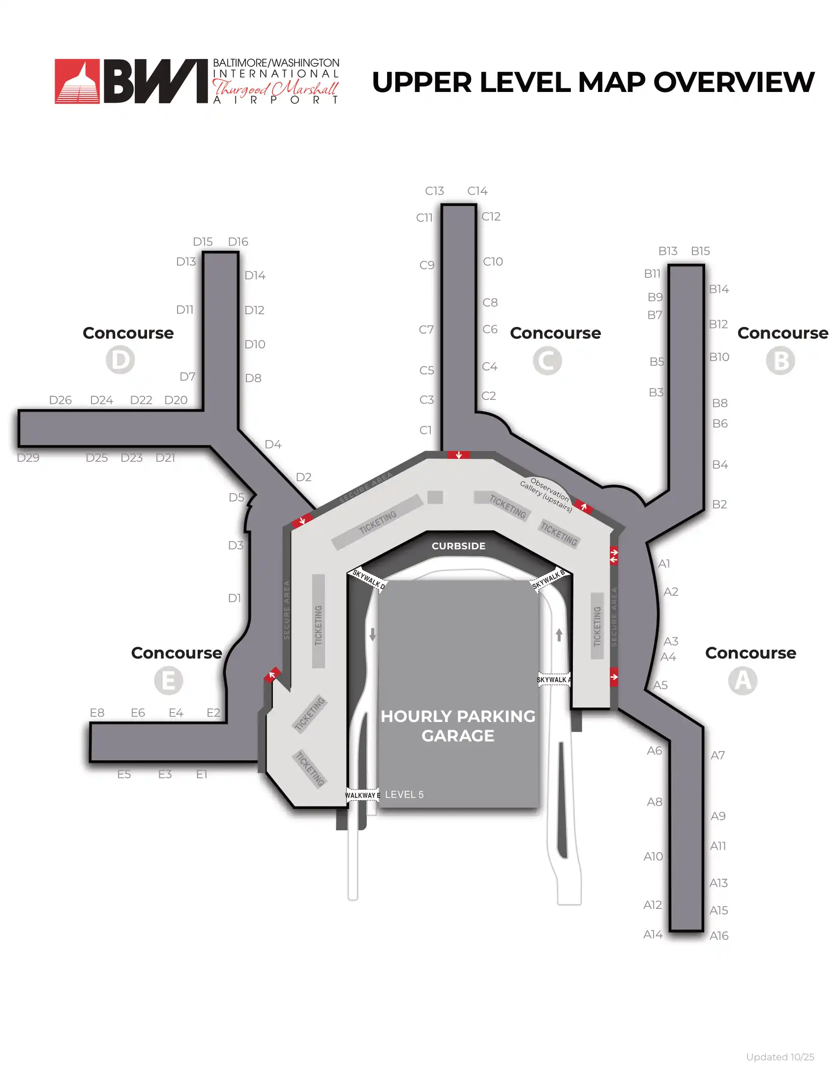
Baltimore/Washington International Thurgood Marshall Airport’s main terminal is a continuous, modified horseshoe loop with Concourses A–E arranged along one curved building, split across two roadway levels (Upper: ticketing/departures, Lower: baggage/arrivals). The far west end concentrates the Southwest ecosystem (A/B/C), while the far east end anchors International/Light Rail access (E) with D/E forming a separate secure island. Most “lost time” happens at curb doors, checkpoint choice, and long cross-horseshoe walks inside Maryland’s primary airport hub.
Map Table
| Terminal | Key Airlines | Primary Function | Transfer Mode |
|---|---|---|---|
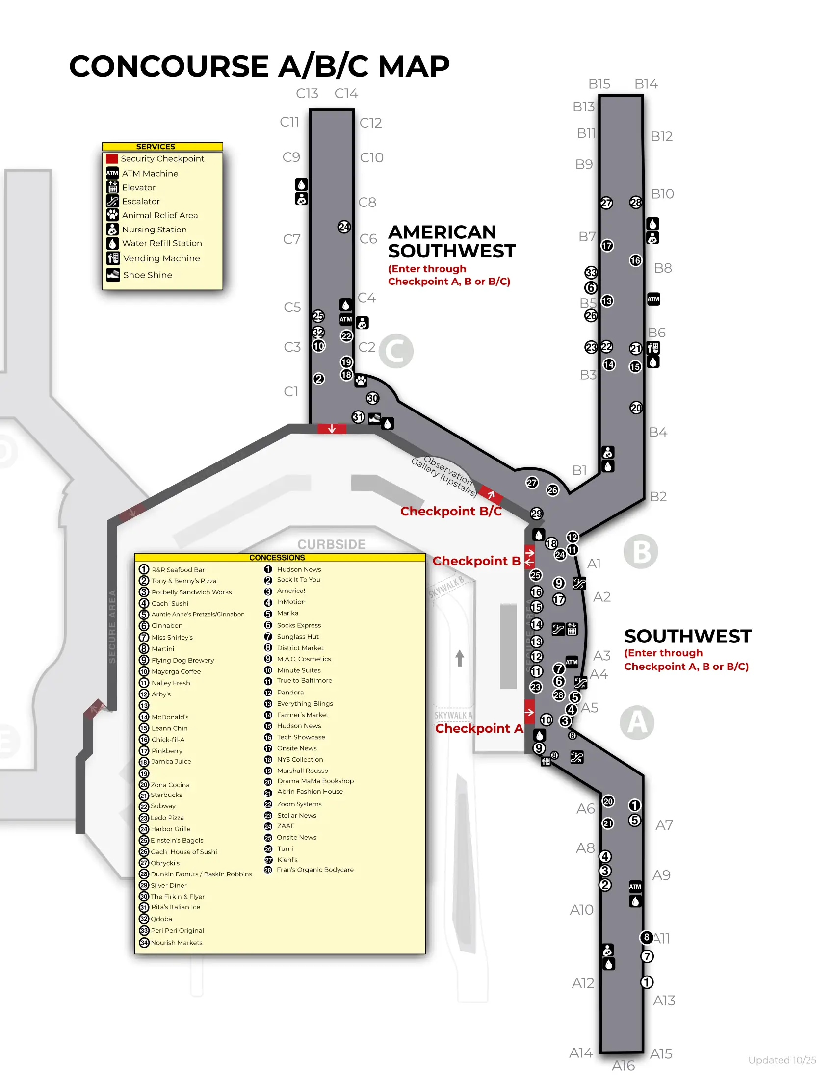
| Concourses A/B/C | Southwest | Domestic core | Checkpoints A/B; shuttles Lower Inner; rideshare Upper Outer |
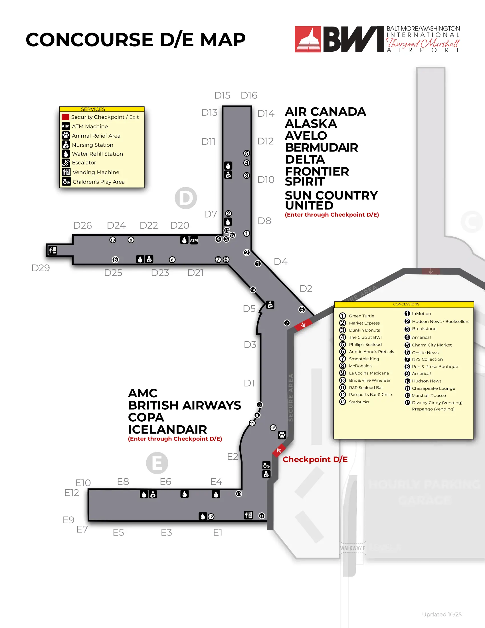
| Concourses D/E | Delta, United, Alaska, Spirit | Legacy + International | Checkpoint D/E; Light Rail at E; shuttles Lower Inner |
| Upper vs Lower Curb | — | Departures vs Arrivals | Rideshare Upper Outer; shuttle-heavy Lower Inner |
Baltimore/Washington International Thurgood Marshall Airport Map Strategy
- Treat the trip as a chain: shuttle pickup curb door → correct terminal entry door → closest open checkpoint → gate walk; one wrong curb segment can add a full shuttle cycle or a cross-terminal hike.
- Use door-anchored ground transport habits to kill shuttle volatility: default to Door 11 (Lower Level inner curb) when disoriented, then adjust to your service’s signed stop; avoid waiting at random baggage-claim exits.
- Pick the checkpoint based on your concourse before you enter the hall: Southwest A/B favors Checkpoint A by Southwest ticketing on the far west side, but late-evening closures can force Checkpoint B; D/E uses the single D/E entry with no mid-pier shortcut.
- Eliminate “lost at curb” rideshare errors by going straight to the Upper Level outer curb zone (Doors 5–12) and using the crosswalks at Doors 5, 8, or 12; don’t request pickup from the Lower Level baggage curb.
2026 Baltimore/Washington International Airport Map + Printable PDF
The 2026 terminal map still rewards “door-first” planning because the horseshoe curb and split security islands create time uncertainty. Rideshare remains on the Upper Level outer curb (Doors 5–12), while key shuttles concentrate on the Lower Level inner curb (not the outer curb). Airside, A/B/C and D/E stay disconnected, so choosing the correct checkpoint up front prevents a forced exit-and-rescreen.
Baltimore/Washington International Airport Main Terminal Map 2025
Baltimore/Washington International Airport Upper Level Map 2025
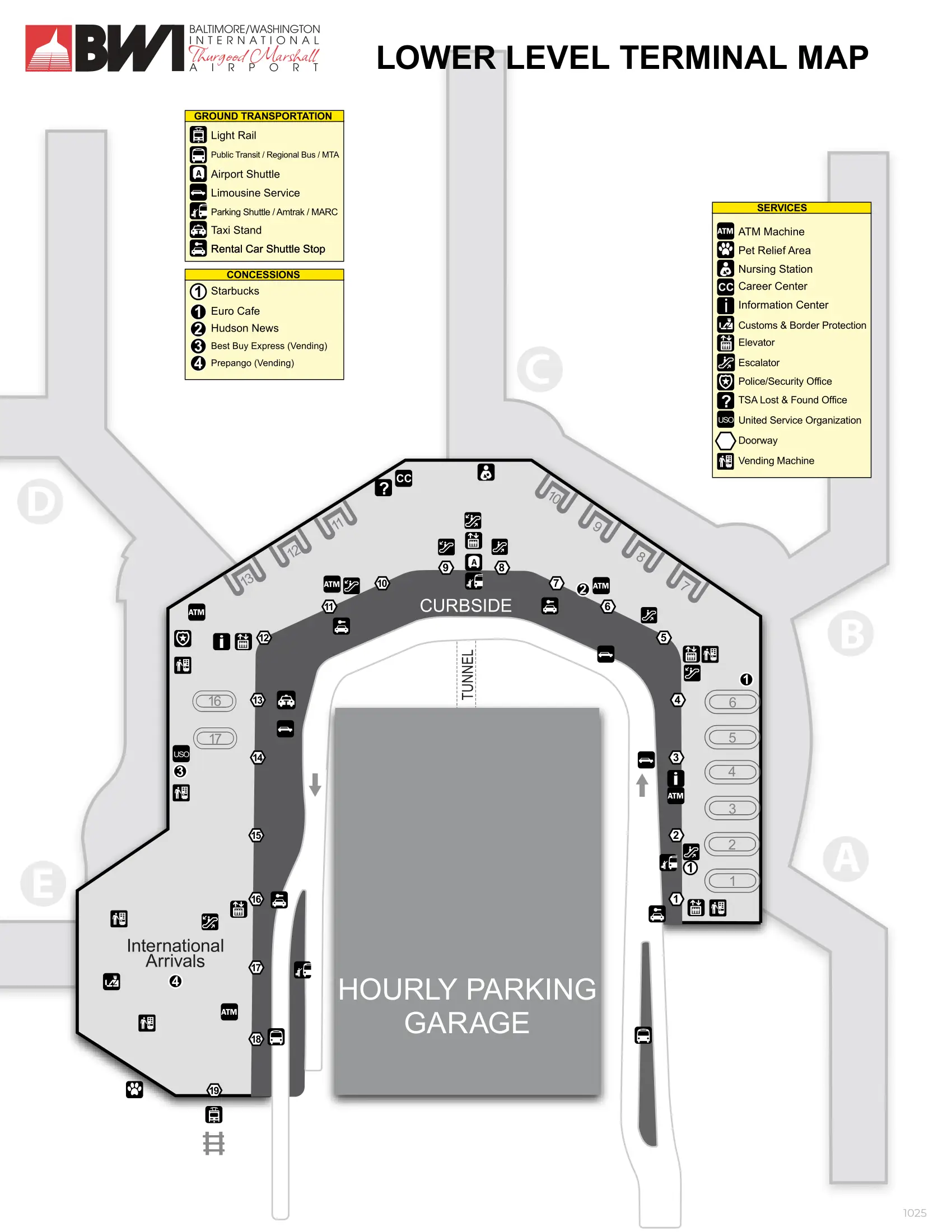
Baltimore/Washington International Airport Lower Level Terminal Map 2025
Baltimore/Washington International Airport Concourse ABC Map 2025
Baltimore/Washington International Airport Concourse DE Map 2025
2026 Baltimore/Washington International Airport Map Guide
Which numbered door on the lower-level curb is the official pickup point for the BWI Long-Term/Economy Parking shuttle?
The BWI Long-Term/Economy Parking shuttle uses the Lower Level inner curb at zones aligned near Doors 1, 9, and 15. These stops function as the practical “official” pickup points because the parking shuttle zones are spaced to cover the Southwest end, the central terminal, and the international end.
Use Door 1 if you want the earliest upstream pickup (closest to Concourses A/B) and the best chance of boarding before buses fill. Use Door 9 as the central anchor if you’re exiting near the middle baggage-claim area. Use Door 15 if you’re coming from the Concourse E side; waiting at random exits can mean watching full buses pass downstream.
What is the exact walking distance from the Long-Term/Economy shuttle drop-off to the nearest TSA checkpoint entrance?
The walk is roughly 250 feet from the Long-Term/Economy shuttle drop-off to the nearest TSA checkpoint entrance when you exit at the first Southwest-side stop. That places you within a short straight shot into the ticketing hall and directly to the A/B checkpoint cluster.
The shortest path starts at the Upper Level inner curb drop near Doors 2–5, then goes straight through the nearest ticketing entrance and into the checkpoint queue area. If you stay on the shuttle to a more central terminal stop (closer to Concourses C/D), the walk to Security Checkpoint A stretches to about 500 feet, so getting off at the first Southwest-side drop reduces both distance and checkpoint uncertainty.
Where is the closest TSA checkpoint entrance for passengers departing from Southwest Concourses A/B (by exact entrance location on the terminal map)?
No late-night access is guaranteed at Security Checkpoint A because it often closes earlier than the central checkpoint. Security Checkpoint A is the closest entrance for Southwest Concourses A/B, positioned on the Upper Level right next to the Southwest ticketing counters.
The Checkpoint A entrance sits on the far west end of the ticketing hall, aligned with the Concourse A/B zone, and it’s specifically located between Door 1 and the M&T Bank branch. From the curb, enter the terminal at the southwest-side ticketing doors and you should see the checkpoint queue almost immediately inside. If Checkpoint A is closed, walk east to Security Checkpoint B (the more central entrance between the A and B piers) rather than backtracking outside.
Which numbered door on the lower-level curb is the official pickup point for the Rental Car Shuttle?
The Rental Car Shuttle only picks up at Doors 1, 11, and 16 on the Lower Level inner curb. Waiting at any other door, or on the outer curb, can mean the bus passes you without stopping.
- Door 1 sits on the Southwest end of the loop near Concourse A baggage claim exits.
- Door 11 is the central anchor near the middle of the terminal, closest to the Concourses C/D baggage-claim area.
- Door 16 is on the International end near Concourse E arrivals.
If you’re unsure where you are on the lower level, navigate to Door 11 first, then adjust along the inner curb to the nearest marked rental shuttle stop.
Where is the Rental Car Shuttle drop-off located relative to the ticketing hall entrances (exact curb position on the terminal loop)?
The Rental Car Shuttle drops passengers on the Upper Level inner curb across from the ticketing hall entrances. The bus runs a “reverse horseshoe” pattern, reaching the Concourse E side first, then the Concourse D zone, and finishing at the Southwest A/B end.
The drop-off is on the terminal-facing curb (inner curb) on the Departures level, so the nearest move is to step off and cross the curb lane directly into the closest ticketing door for your airline. If you miss your airline zone and stay aboard past it, the bus continues toward the Southwest end and then exits the airport area, which can force a long backtrack on foot—up to about half a mile depending on where you should have gotten off.
What is the exact walking distance from the Light Rail entrance (Terminal E / lower level access) to Southwest ticketing (A/B)?
The walking distance is about 1,600 feet (roughly 0.3 miles) from the Light Rail entrance by Terminal E (Lower Level access) to Southwest ticketing at the A/B end. That distance typically takes 15–20 minutes with luggage.
Start at the Light Rail station entrance on the Concourse E side, enter the terminal on the lower level, and follow the landside corridor along the horseshoe past Concourses D and C toward the far west end. The Southwest ticket counters sit at the opposite end of the loop, so the key time saver is using the nearest elevator/escalator bank when you reach the A/B zone instead of overshooting and backtracking along the curb.
Where exactly is the signed curb location for the “BWI Courtesy Shuttle” at the BWI Rail Station (terminal shuttle pickup point)?
The “BWI Courtesy Shuttle” picks up at the rail station curb by the garage-side commercial/bus island, not the curb directly in front of the station building doors. That garage-side stop is the signed, consistent pickup point for the terminal shuttle.
Exit the rail station building, then cross the first lane of traffic to the island across the roadway from the station. The shuttle stop sits adjacent to the station garage and is marked with “BWI Courtesy Shuttle” signage. If you wait at the station’s front curb by the main doors, you can miss the shuttle entirely because that curb is not the primary signed loading position.
What is the exact designated Uber/Lyft pickup zone at Baltimore/Washington International Thurgood Marshall Airport (level plus mapped curb segment)?
Uber/Lyft pickup is restricted to the Upper Level outer curb at Doors 5 through 12. Pickup is not allowed on the Lower Level baggage-claim curb, so requesting a ride from arrivals can strand you one level away from your driver.
Go up to the Departures/Ticketing level, exit to the roadway, and cross to the outer curb (the far curb beyond the median). The most reliable crosswalks to reach that outer curb align with Doors 5, 8, and 12, so use the nearest of those doors as your “meet point” anchor. If you’re carrying bags, choose Door 8 as a center-of-zone reference to reduce curb confusion.
What is the exact walking distance from Security Checkpoint D to the highest-numbered gate in Concourse D?
The walk is about 1,300–1,500 feet (around 0.25–0.28 miles) from Security Checkpoint D/E to Gate D29, the highest-numbered gate in Concourse D. That typically takes 6–8 minutes at a steady pace.
Security Checkpoint D/E is the only entry point for the Concourse D pier, so the path is simple but long: exit the checkpoint into the D corridor, then continue straight down the linear pier as gate numbers increase away from the hub. Gate D29 sits at the far end, so if you’re timing a tight boarding window, treat the checkpoint exit (near the D1–D10 cluster) as the “start line” and budget the full end-to-end walk.
Where is the Southwest baggage service office located relative to the baggage claim carousels (exact position on baggage level map)?
The Southwest baggage service office sits behind the Southwest baggage-claim unit near Carousels 3–4, along the back wall of the baggage claim hall. It’s positioned within the Carousels 1–5 area so agents can monitor the whole Southwest claim zone.
After you reach the lower-level baggage claim, orient to the Southwest carousel cluster (1–5) rather than the central belts. Walk toward the back wall behind the carousels (away from the curb doors), and look for Southwest signage and the service counter adjacent to the middle of the 1–5 grouping. If you head toward the exit doors first, you’ll often overshoot and end up outside the carousel unit.
Where is the closest post-security food option to the center junction of Concourse D (shortest mapped path from the main D corridor)?
Auntie Anne’s Pretzels near Gate D5 is the closest post-security food option to the Concourse D center junction. It’s within about 100–200 feet of the Security Checkpoint D/E exit, making it the fastest grab-and-go choice without committing to a long walk down the pier.
From the checkpoint exit, bear slightly left into the main Concourse D corridor and continue a short distance toward the early D gates. Auntie Anne’s sits in the Gate D5 cluster; Dunkin’ (near Gate D8) and the America! convenience shop (near Gate D1) are also close, but D5 typically lands as the shortest “first food” path from the junction.
Where is the nearest restroom to the center junction of Concourse D (shortest mapped path)?
The nearest restroom is across from Gate D7, about 200 feet from the Security Checkpoint D/E exit. It’s positioned in the early D-gate cluster closest to the post-security junction where the D/E connector meets the Concourse D pier.
From the checkpoint exit, walk straight into the main Concourse D corridor toward Gates D5–D10. The restrooms appear on the right-hand side as you move outbound, directly across from Gate D7, so you don’t need to head deep down the pier toward the higher-numbered gates to find facilities.