Arturo Merino Benítez International Airport Map (Most Up-To-Date)
Arturo Merino Benítez International Airport runs as two parallel, separated terminals with a big “central processor + long piers” international building and a linear domestic building, joined only by landside walking routes and a free landside shuttle. Within Santiago’s primary airport complex, the international side (T2) funnels all arrivals down to a single immigration atrium, then baggage + SAG X-ray, before spilling into a long, linear landside arrivals frontage where the transport counters and curb doors sit.
Map Table
| Terminal Pairing | Core Layout | Primary Function | Transfer Reality |
|---|---|---|---|
| Terminal 2 International | central processor + 4 piers (C/D/E/F) | PDI immigration, SAG inspection, long-haul gates | landside only, walk or shuttle |
| Terminal 1 Domestic | linear concourse | Chile domestic check-in, security, gates | landside only, level changes |
| Between T2 ↔ T1 | parking “Boulevard” spine | pedestrian connector | rain hazard on upper decking |
Arturo Merino Benítez International Airport Map Strategy
- Treat PDI + SAG as the hard choke: toilets/water are on the Level 2 corridor just before the escalators down—use them before you drop into the queue maze.
- Separate tickets = no secure re-check: plan to exit T2 fully, then walk or shuttle to T1 Level 3 for standard check-in counters and re-clear security.
- Use the signed “Boulevard” spine only when dry; in rain, stay on Level 1 and use covered sections by the bus station roof or take the free inter-terminal shuttle to avoid the slippery decking.
- Follow the Blue Arrow/Blue Line from SAG exit to the official transport counter row before you enter the public crowd; it’s the clean booking decision point that reduces scams and pickup confusion.
2026 Arturo Merino Benítez International Airport Map + Printable PDF
Current operations at 2026 still hinge on the same segmented design: International (T2) feeds everyone through PDI immigration and mandatory SAG screening, then pushes connections landside to reach Domestic (T1). The September 2025 T1 upgrade improved security throughput, but it didn’t remove the core risks: immigration queue volatility, forced bag reclaim/X-ray steps, and a weather-exposed terminal-to-terminal walk.
Arturo Merino Benítez International Airport Terminal 1 Level 1 Map 2026
Arturo Merino Benítez International Airport Terminal 1 Level 2 Map 2026
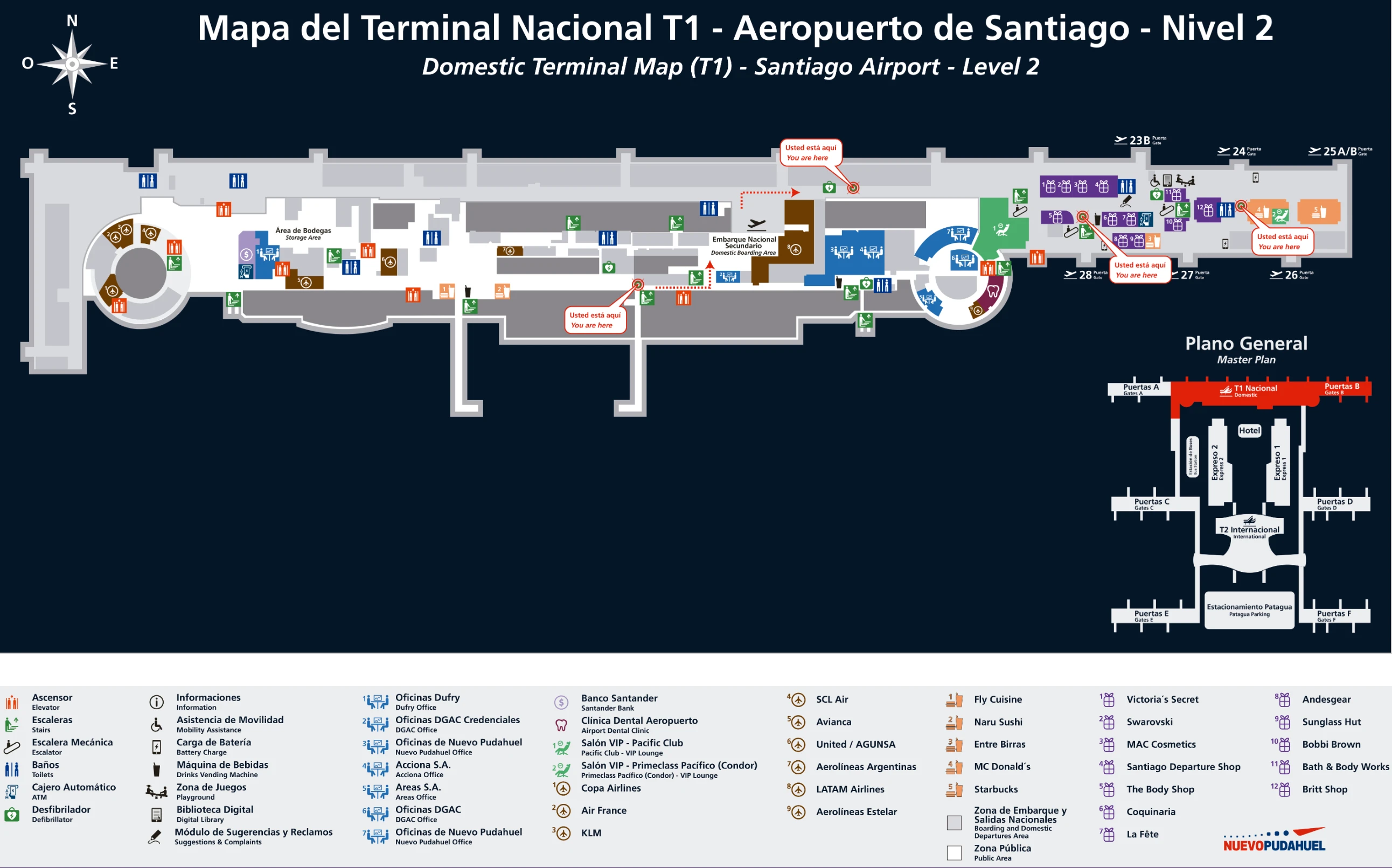
Arturo Merino Benítez International Airport Terminal 1 Level 3 Map 2026
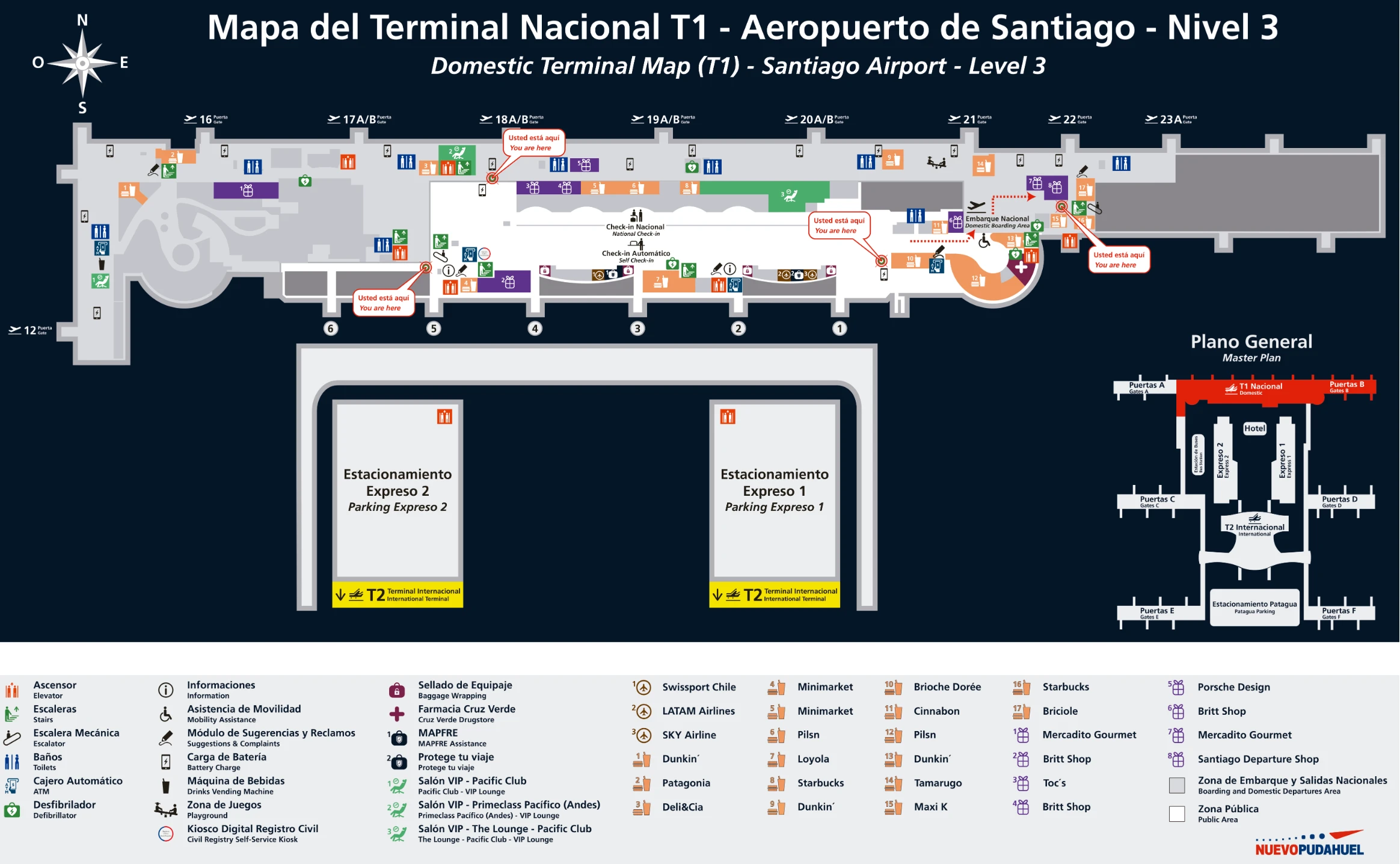
Arturo Merino Benítez International Airport Terminal 1 Level 4 Map 2026
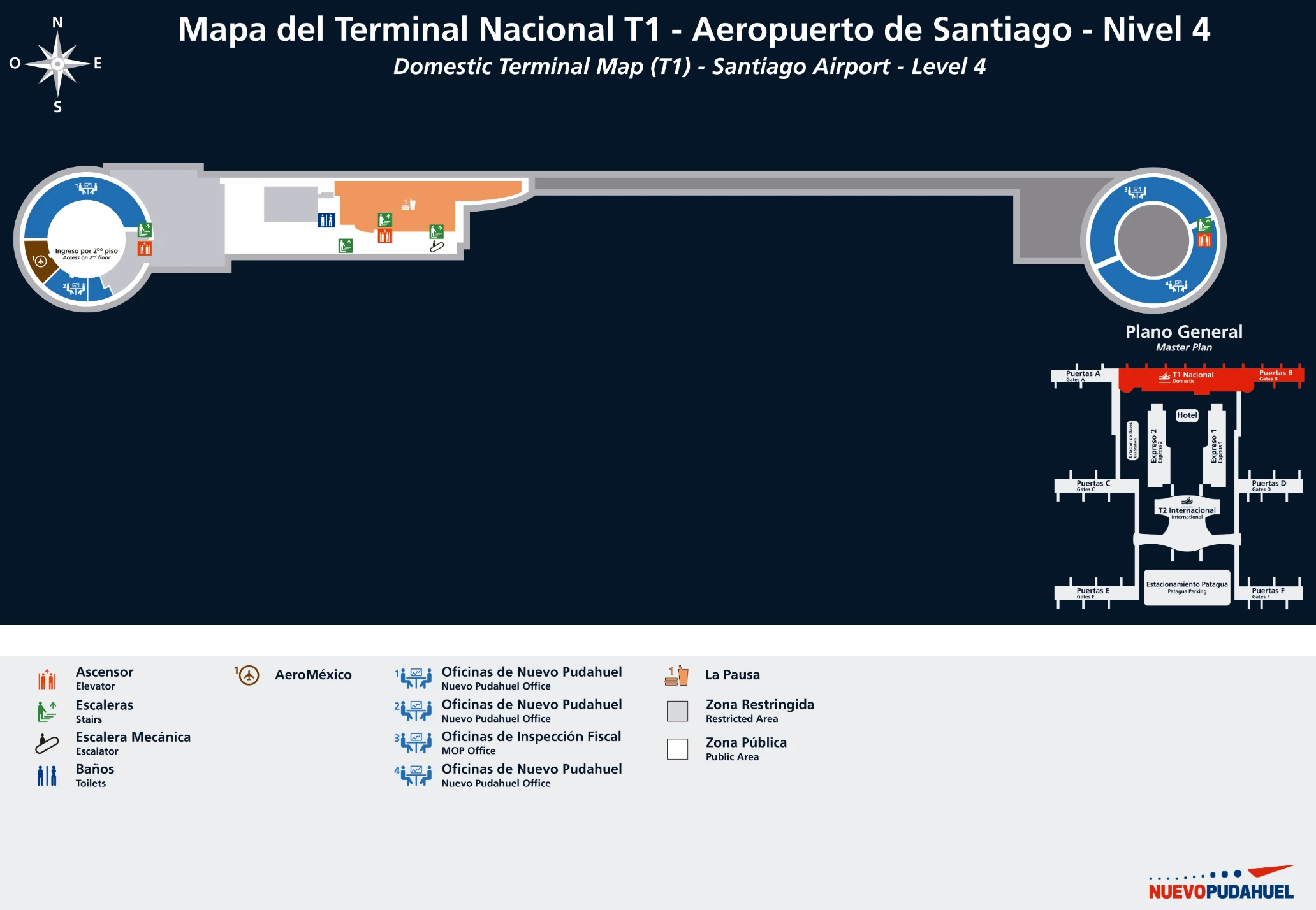
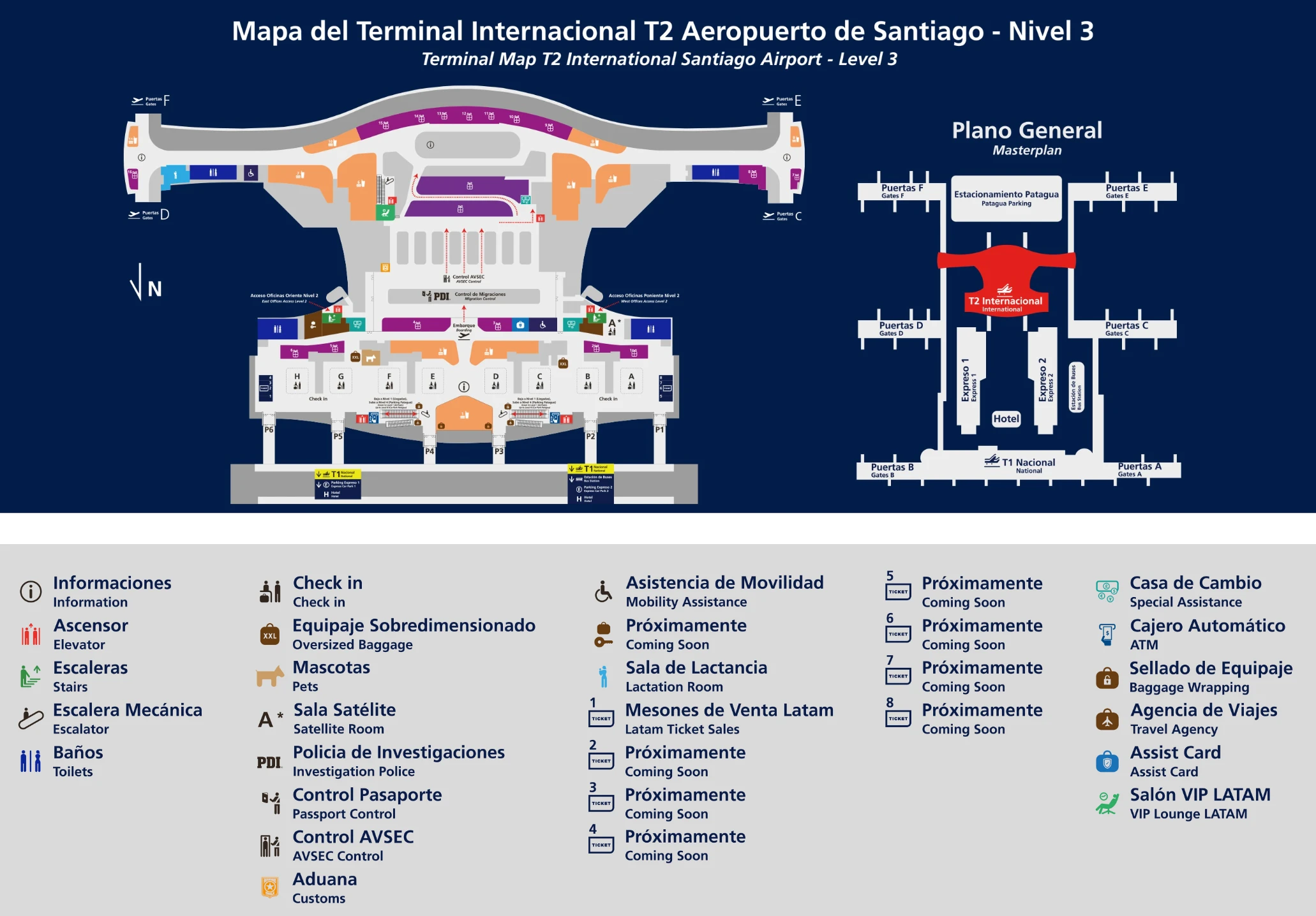
Arturo Merino Benítez International Airport Terminal 2 Level 1 Map 2026
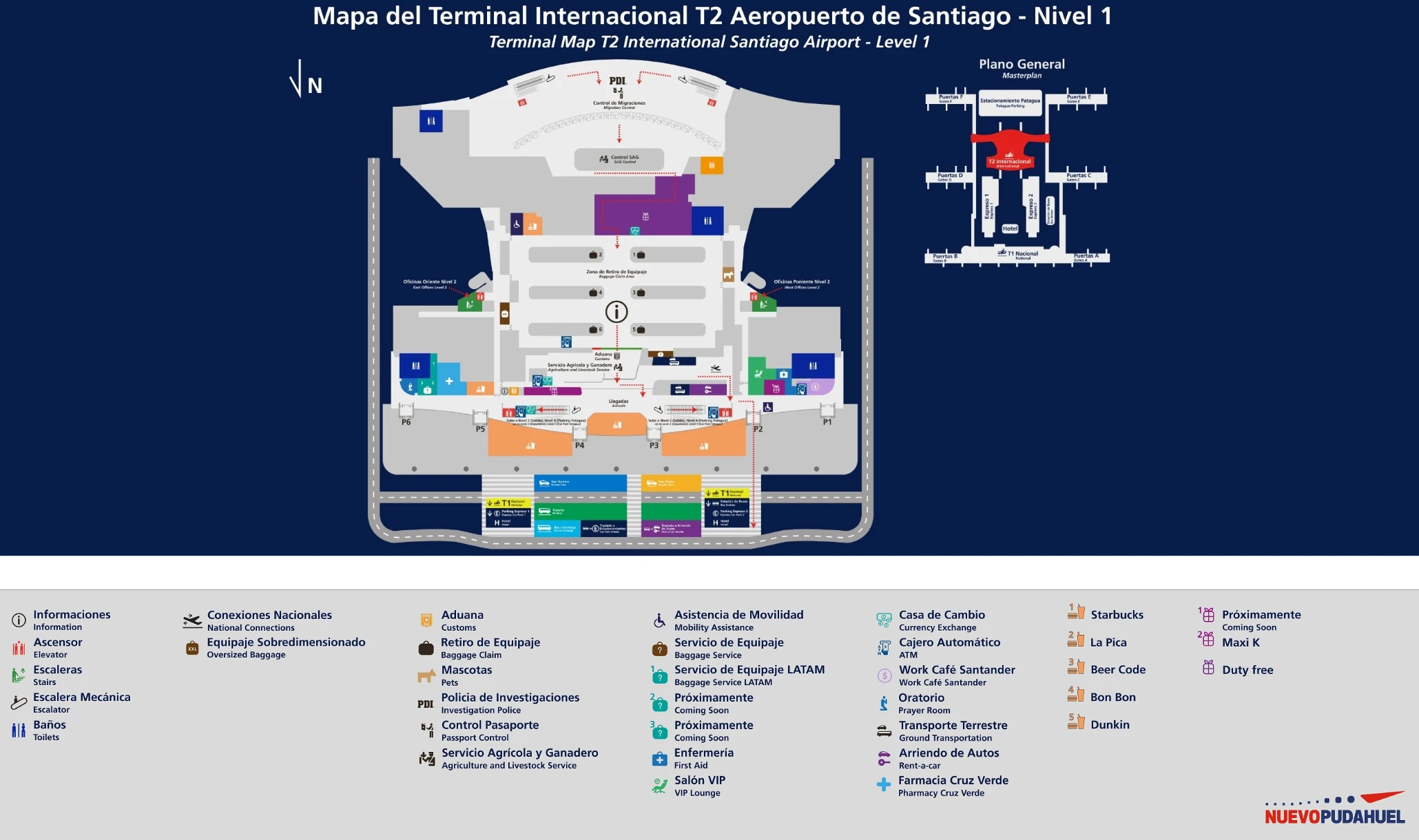
Arturo Merino Benítez International Airport Terminal 2 Level 3 Map 2026
2026 Arturo Merino Benítez International Airport Map Guide
What is the exact walking distance (meters) from the international arrivals exit (post-customs) to the start point of the immigration queue (the physical queue entrance)?
That walk is not physically possible because the flow is one-way: immigration (PDI) happens before customs and the SAG X-ray, so you cannot go from post-customs arrivals back to the immigration queue entrance. The chokepoint you actually control is the distance from the Level 2 arrivals corridor down to the base of the escalators where the PDI queue maze begins.
To plan it on the map, use these fixed nodes inside the international terminal central processor: the last toilets/water point on the Level 2 corridor sits roughly 20–50 meters before the escalators, and the queue entrance begins immediately at the base of those escalators with essentially no buffer. If you arrive by remote/bus stand, the Level 1 bus drop-off feeds into the same queue area from much closer range (often under 100 meters).
Where is the baggage re-check / bag-drop point for passengers on separate tickets, measured as the walking distance from international baggage belts?
There is no baggage re-check or bag-drop point for separate-ticket passengers inside the secure international arrivals flow. Separate tickets force a full landside exit from the international terminal, then a terminal-to-terminal transfer to the domestic check-in hall to re-check bags.
From the international baggage belts in the international terminal, the next unavoidable step is the SAG X-ray area, which sits very close—typically about 10–30 meters from the carousels depending on which belt you’re on. After SAG, you exit into the landside arrivals frontage, then complete the inter-terminal transfer: the mapped walk from the international arrivals exit to the domestic check-in hall is about 400 meters via the upper Boulevard route (dry weather), or about 450 meters along the ground-level path. Once you reach the domestic terminal, bag drop happens at the standard airline check-in counters on Departures (Level 3).
What is the shortest mapped route (with distance) to go from the domestic terminal exit to the international check-in hall entrance?
The shortest mapped route is the upper “Boulevard” pedestrian spine between the terminals, which runs across the parking structures at Departures level and lands you near the international terminal departures side. The distance is about 400 meters.
| Route | Start landmark | End landmark | Approx. distance | Typical walk time | Notes |
|---|---|---|---|---|---|
| Upper Boulevard (shortest) | Domestic terminal, Departures level frontage | International terminal, check-in hall entrance (Departures) | ~400 m | ~10–12 min | Weather-exposed decking sections |
| Ground-level path (alternate) | Domestic terminal, Arrivals level curb | International terminal, Arrivals level then up to Departures | ~450 m + vertical | ~12–15 min + elevators/escalators | More cover near bus station roof |
If it’s raining or you have wheeled luggage, the ground-level path (or the free inter-terminal shuttle) is usually faster in practice because the Boulevard decking can become slick and forces cautious walking.
Which level and corridor is the reported slippery walkway in rain, and what is the closest alternate mapped route that avoids it?
The slippery walkway is on the upper inter-terminal “Boulevard” route that runs on Level 3 across the parking-structure connector between the domestic and international terminals, where composite wood decking gets slick in rain. Avoid it whenever the surface is wet, especially with rolling luggage.
| Option | Where you are | Where you go | Approx. distance | Why it helps |
|---|---|---|---|---|
| Closest walk-around (no decking) | International terminal Arrivals frontage (Level 1) | Stay on Level 1 toward the bus station roof, then continue to the domestic terminal Level 1 | ~450 m | Covered/overhang sections, better traction |
| Safest in heavy rain | International terminal curb (Level 1) | Free inter-terminal shuttle bus to domestic terminal curb (Level 1) | loop-based | No slip exposure, luggage-friendly |
A reliable on-map cue is vertical: if you find yourself being routed up to the landscaped parking “Boulevard” on Level 3, you’re on the risk surface. In rain, commit early to Level 1 instead and follow the covered segments by the bus station roof structure between the terminals.
Where exactly are the official shuttle/van booking counters (e.g., Transvip) located relative to baggage claim—measured as steps/meters from the last baggage belt?
The official shuttle/van booking counters are in the semi-restricted arrivals transition zone immediately after the SAG X-ray exit, before you fully spill into the public arrivals crowd. They sit on Level 1 in the international terminal arrivals flow and are reached by following the Blue Arrow/Blue Line on the floor.
From the last baggage belt in baggage claim, the path is: baggage belt → SAG affidavit check and X-ray scanners (typically 10–30 meters from the belts) → exit the last X-ray machine → walk about 20 meters to the counter row (Transvip and other authorized providers). As a usable “steps” proxy, 20 meters is roughly 25–30 normal walking steps with luggage. This is the clean decision point: buy/confirm transport here, then walk out to the curb only after you have a voucher.
From the post-customs exit, which door number / exit leads to the authorized pickup zone (vs. the general curb), and what is the walking distance to that pickup point?
Door 1, Door 2, and Door 3 on the international terminal arrivals frontage are the authorized pickup doors for official taxi and pre-booked transfers. Using these doors keeps you in the controlled pickup zone instead of drifting down the general curb where solicitation is heavier.
From the public arrivals hall exit after customs/SAG, the walk to the Door 2–3 area is roughly 50–80 meters along the same Level 1 linear frontage. The layout is simple: exit the arrivals hall, stay close to the first doors on the curb line, and meet your vehicle at Doors 1–3; many private transfers also use Door 4 as a meeting reference point (often near the “La Picá” restaurant), but Doors 1–3 are the core “authorized pickup” cluster.
Where is the first decision point where a traveler can still book legitimate transport before going fully landside, and what is the distance from customs exit to that point?
The first decision point is the official transport counter row reached by the Blue Arrow/Blue Line immediately after the SAG X-ray exit, before you step out into the public arrivals crowd. Booking here locks in a fixed-price voucher and keeps you out of the solicitation zone.
From the customs/SAG processing edge, the distances are tight and practical: the walk from the last SAG X-ray machine to the counter row is about 20 meters along the marked path. If you’re already at the public-facing arrivals hall threshold, it’s still essentially the same node—look for the Blue Arrow floor marking and stop at the counter bank before crossing the glass doors to the curb.
If arriving via a bus/remote stand, where is the bus drop-off inside the terminal, and what is the walking distance from drop-off to immigration?
The bus/remote-stand drop-off is on Level 1 of the international terminal central processor, feeding directly into the arrivals processing corridor that leads into the PDI immigration hall. This is the “shortcut” arrival because it skips the long pier corridors entirely.
From that Level 1 bus drop-off point to the physical entrance of the immigration queue maze is about 80 meters, typically 1–2 minutes on foot with carry-ons. Use the base of the escalator/elevator bank into the PDI atrium as your anchor: the queue entrance begins immediately at the bottom with little to no buffer space, so once you reach that atrium edge you’re effectively “at immigration.”
What is the gate-to-gate walking distance for a typical “long-walk” connection inside the international terminal (e.g., furthest gate pier to central services core)?
The long-walk distance from the furthest international gates to the central processor core is about 800–900 meters from the tips of Piers C or E, and about 650–700 meters from the tips of Piers D or F. Those figures reflect the real “pier length + connector” walk that hits you before you even reach the core functions like immigration, services, or the main vertical circulation.
A practical way to anchor it on the map is to use the central processor as the destination node: the walk is from the end gate holdrooms at the pier tip to the central processor corridor where the main downflow to Level 1 begins (the escalator/elevator banks toward arrivals and PDI). Operationally, that’s why a remote/bus stand can paradoxically be faster: it drops you on Level 1 near the core and can remove roughly 10 minutes of pier walking.
Where are the nearest toilets/water points located immediately before entering the immigration queue, and what is the distance from the queue entrance to them?
The nearest toilets and water refill points are on the Level 2 arrivals corridor, on the right-hand side, just before the escalators/elevators that descend into the PDI immigration hall. They are the last reliable amenities before you commit to the queue maze.
Measured from the immigration queue entrance anchor (the base of the escalators where the queue switchbacks begin), you’re roughly one level up and about 20–50 meters away along the Level 2 corridor. In practical map terms: if you can still see the top of the down-escalator bank, you’re within under a minute of these toilets/water; once you’re physically in the queue maze at Level 1, stepping out to reach them is disruptive and can effectively reset your place in line.
What is the distance from international arrivals to the car-rental area (or rental shuttle stop), and which mapped corridor gets you there without doubling back?
Car-rental routing in the international terminal is best treated as a landside “arrivals frontage” move: clear SAG, enter the public arrivals hall, then continue forward along the same Level 1 linear corridor toward the ground transport zone rather than backtracking toward baggage claim. The clean corridor is the same one that carries you past the official transport counters and out to the curb doors.
The audit you provided does not include a verified meter distance to the car-rental desks or rental shuttle stop, so the only distance that can be stated precisely from this dataset is the internal setup to the transport spine: about 20 meters from the last SAG X-ray exit to the official counter row, then an additional roughly 50–80 meters along the arrivals hall frontage to the primary curb door area (Doors 1–3). If you’re using a rental shuttle pickup, anchoring your walk from the public arrivals exit to the curb doors keeps you on the forward-only spine and avoids the common mistake of turning back toward the baggage hall.
Where is the clearest signed pedestrian spine (primary wayfinding corridor) between the terminals, and what is the distance along that spine from terminal-to-terminal?
The clearest signed pedestrian spine is the inter-terminal “Boulevard” route that runs across the parking structures (Express 1 / Express 2) on Level 3, connecting the departures-frontage sides of the domestic and international terminals. It’s the default, map-intended walking link between buildings.
The distance along this signed spine is about 400 meters from terminal-to-terminal, typically 10–12 minutes with luggage. A close alternate spine exists at ground level: staying on Level 1 via the bus station roof/overhang-covered segments between the terminals is about 450 meters and usually 12–15 minutes, but it’s the better choice in rain because it avoids the slippery composite decking on the Boulevard.