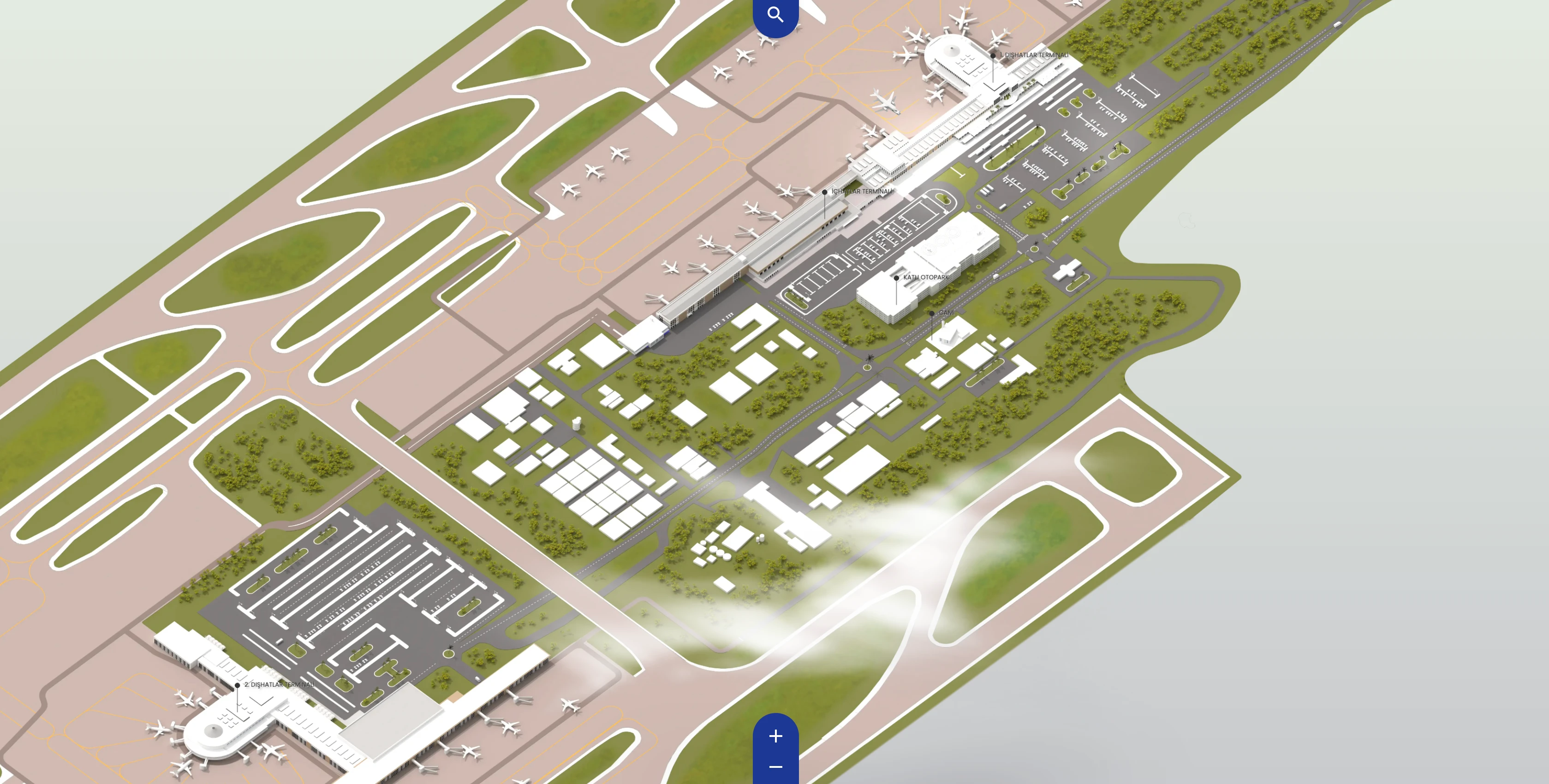
Antalya International Airport Map (Most Up-To-Date)
Antalya Airport is arranged as a three-terminal complex with one major split: International Terminal 1 and the Domestic Terminal form a connected cluster, while International Terminal 2 sits about 2.5 km south as a separate, landside-only transfer. The overall footprint stretches along the D400 approach, with curbside access and traffic loops shaping real “door-to-terminal” timing. Within Antalya’s primary airport grounds, Terminal 2 behaves like its own mini-airport for arrivals, departures, and ground transport.
Map Table
| Terminal area | Key use | Connectivity | Transfer mode |
|---|---|---|---|
| International Terminal 1 | International processing | Adjacent to Domestic | Walkway (connected) |
| Domestic Terminal | Domestic flights, transit nodes | Adjacent to T1 | Walkway (connected) |
| International Terminal 2 | International processing, long gate piers | ~2.5 km from T1/Domestic | Shuttle, taxi, bus |
Antalya International Airport Map Strategy
- Plan for door-to-gate uncertainty driven by stacked processing stages: curb screening, check-in/bag drop, passport control, secondary security, then long gate walks in the expanded pier.
- Treat Terminal 2 as operationally separate: inter-terminal movement is landside only, with no safe pedestrian link, so add a hard buffer for shuttle wait plus road transfer.
- Defuse landside choke risk by committing to the correct terminal sequence on approach (Terminal 1 → Domestic → CIP → Terminal 2) and avoiding the “overshoot” loop penalty if the wrong exit is taken.
- Reduce failure penalties by pre-choosing fallback routes: outer curb doors when central doors clog, and a ready taxi fallback if the shuttle timing breaks the schedule.
2026 Antalya International Airport Map + Printable PDF
Antalya Airport’s current layout is still defined by the Terminal 2 expansion footprint and the permanent connectivity gap between Terminal 2 and the Terminal 1/Domestic cluster. Seasonal surges amplify landside approach congestion and curb crowding, while inside Terminal 2 the double-screening architecture (entrance screening plus post-passport security) creates stacked queues that make end-to-end timing hard to predict from curb to gate.
2026 Antalya International Airport Map Guide
What is the exact driving path (road segment + entrance gate) that leads to Terminal 2 departures drop-off, and where does it typically bottleneck?
The Terminal 2 departures drop-off approach runs off the D400 corridor past the Terminal 1/Domestic/CIP frontage to the signed “International Terminal 2” exit into the Terminal 2 loop road and departures curb. The most common bottleneck forms at the Terminal 2 exit/merge and then again at the curbside drop-off lanes where vehicles stack and stall.
| Route step | What to follow on the ground | Typical bottleneck point |
|---|---|---|
| D400 inbound from Antalya/resorts | Stay on the main D400 approach toward the airport frontage | General approach congestion in peak season |
| Terminal sequence pass-by | Pass the Terminal 1 → Domestic → CIP frontage without exiting | “Overshoot” correction if the wrong exit is taken (adds loop time) |
| Terminal 2 exit decision | Take the clearly signed “International Terminal 2” exit ramp | Exit/merge slowdown as traffic funnels into the terminal road |
| Terminal 2 loop road | Follow the internal terminal loop toward “Departures” | Control points and weaving traffic near terminal frontage |
| Departures curb lanes | Enter the Terminal 2 departures drop-off curb zone | Curbside lane saturation, stopping/standing vehicles, queue spillback into approach lanes |
Where is the first “entrance security” screening located relative to Terminal 2 curbside drop-off (pinpoint the checkpoint position)?
The first entrance security screening is immediately inside the automatic sliding doors on the Terminal 2 departures curb, only a few steps from the drop-off sidewalk. The X-ray belt and walk-through metal detector sit right after the door line, so the queue can form on the sidewalk when volume spikes.
Most passengers cluster at the central doors (typically Doors 2 and 3) because they align with the curbside drop-off centroid, which makes those lanes back up first. Using the outer doors (Door 1 or Door 4) usually puts you into the same hall but with a shorter initial queue, since fewer groups naturally drift to the edges.
What is the exact walking distance (meters) from Terminal 2 check-in hall to the primary passport control point?
The walking distance is typically about 80–200 meters from the check-in hall’s central islands to the primary passport control point, depending on which check-in island you start from. The critical variable is how far you are from the central escalator core that lifts you to the upper processing level where passport control begins.
Passengers finishing at the “centroid” of the hall (near Islands 3 and 4 by the main escalators) have the shortest path: a short straight walk to the escalator base, up to the landing, then a short lead-in to the manual passport control queue. If you check in at a peripheral island, budget an added lateral cross-hall walk (often 50–150 meters) to reach that same escalator anchor before you even start the upper-level segment.
What is the exact walking distance (meters) from Terminal 2 passport control to the main security screening lanes?
The walking distance is typically about 10–40 meters from the exit of passport control to the main security screening lanes. The security checkpoint is positioned immediately after passport control with no meaningful buffer zone.
After you clear the manual booths, the flow compresses into the next queue almost right away: you step into a short connector lane and then into the divestment/X-ray lanes for the second security check. The tight spacing is why the passport-control queue can push back toward the escalator landing during peak waves, and why repacking passports/documents tends to slow people down right before the security divestment area.
What is the exact walking distance (meters) from Terminal 2 security to the farthest gate cluster (the longest “worst-case” gate walk)?
The worst-case walk is roughly 900–1,300 meters from the exit of the main security screening to the farthest gate cluster in the extended pier (often described as the 230+ area). That distance commonly translates to about 12–18 minutes with carry-ons when corridors are crowded.
| Segment | Anchor point to follow | Distance |
|---|---|---|
| Security exit → retail funnel | Step out of Security Checkpoint 2 into the forced duty-free path | ~50–150 m |
| Duty-free → main airside spine | Continue through the retail corridor to the open concourse junction | ~150–300 m |
| Concourse junction → distal pier | Follow the primary gate signage down the long linear pier to the far end | ~700–900 m |
Where are the passport e-gates physically located in Terminal 2 arrivals relative to the manual booths (to avoid being rerouted to the back)?
No operational passport e-gates are present in Antalya Airport Terminal 2 arrivals, so there isn’t an e-gate vs. manual-booth position to target. Manual immigration booths handle all arriving passengers, and throughput depends on how many officers are actively staffed.
In practical terms, the “avoid being rerouted” tactic is choosing your place in the manual queue early, before the serpentine barriers fill and spill backward. Use the visa desks before you commit to the main line if you need them, because they sit ahead of passport control and backtracking against the crowd is slow. If you arrive as a wide-body wave hits, assume the queue can extend well beyond the first barrier grid toward the arrivals corridor.
What is the shortest indoor route from Terminal 2 arrivals exit doors to the official taxi queue (no detours through car parks)?
The shortest route runs straight out of the baggage-claim exit sliding doors into the public arrivals frontage, then left into the controlled curbside pickup line where the official taxi queue forms. The key is staying on the arrivals-level frontage and not following anyone toward parking-ticket machines or “transfer desks” deeper into the hall.
After customs, keep moving toward the main sliding-door exit from the arrivals hall, then step outside and immediately orient to the left-side controlled area (the same side where meet-and-greet lines are typically corralled). The taxi queue sits on the curbside frontage rather than inside a car park structure, so if you see signage pulling you toward ramps, pay stations, or a parking foyer, you’ve drifted off the shortest path.
Where is the Terminal 2 ride-hail / prebook transfer pickup zone located relative to Arrivals (exact door number / curb segment on the map)?
The ride-hail and prebook transfer pickup zone is on the arrivals curb immediately outside the main sliding-door exits, in the left-side controlled meet-and-greet line near the transfer coordination landmark commonly referred to as Meeting Desk 99. That placement keeps drivers and placards out of the central flow and concentrates pickups along the same barricaded frontage.
After you exit customs into the public arrivals hall, keep heading straight to the primary sliding doors, then step outside and turn left along the curb until you’re inside the barricaded “left side” waiting area. Drivers with name boards cluster there rather than across the full frontage, and large tour operators tend to stage farther away in dedicated bus areas, which is how you can tell you’re in the correct curb segment for prebook pickups.
What is the exact inter-terminal walking distance between Domestic Terminal and Terminal 1 (International) using the most direct signed pedestrian path?
No direct outdoor inter-terminal walk is required because the Domestic Terminal and International Terminal 1 form a contiguous, connected terminal cluster. The usable “most direct signed pedestrian path” is an indoor connector walk between the two buildings, with distance varying by the specific door you start from.
| Start → end anchor | Direct signed path type | Typical walk distance |
|---|---|---|
| Domestic main hall → Terminal 1 check-in frontage | Indoor connector corridor | ~200–500 m |
| Domestic arrivals exit → Terminal 1 departures frontage | Indoor connector + frontage walkway | ~300–700 m |
| Domestic curb segment → Terminal 1 curb segment | Covered frontage walk (same cluster) | ~250–600 m |
Where is the inter-terminal shuttle/bus stop located for the Domestic ↔ International connection (exact curbside position)?
The free inter-terminal shuttle stop is on the Departures curb at each terminal, not at the Arrivals exits, so the curbside position to target is the signed “Shuttle / Ring” stop on the upper (departures) roadway. The most common failure mode is waiting at arrivals curb by mistake and losing a full shuttle cycle.
At the Domestic/Terminal 1 cluster, follow signs to Departures and look for the marked bus bay where airport-operated shuttles load along the curb line rather than inside the car parks. At Terminal 2, the shuttle bay is also on the Departures frontage; arriving passengers must first move from the arrivals level to the departures level (via terminal vertical access or curbside walk) before joining the shuttle queue.
What is the shortest route from Terminal 2 check-in to CIP/lounge access (exact floor change + corridor path on the map)?
CIP lounge access is on the 3rd floor, reached from the airside zone after you clear passport control and the second security checkpoint. The shortest route is check-in hall → central escalators up to passport control → continue forward into Security Checkpoint 2 → exit into the airside concourse, then take the nearest elevator/stairs up to the 3rd-floor CIP level.
From the check-in hall, the key anchor is the central escalator core beside the hall’s centroid islands (commonly Islands 3–4). After you pass manual passport control, do not stop in the narrow connector; Security 2 is immediately next, and the fastest lounge path is to clear it first, then look for vertical access points in the main airside concourse rather than getting delayed inside the duty-free funnel.
Where is the tightest corridor / known pinch point between Terminal 2 landside entry and check-in (the spot where queues back up into walking space)?
The tightest pinch point is the mixing zone at the base of the central escalators in the check-in hall, where passengers from multiple check-in islands converge and entrance-screening flow feeds into the same corridor space. This is where queues and standing groups most often spill into the main walking lanes.
The escalator core acts like a single high-throughput funnel, so any slowdown upstream (entrance security) or downstream (people regrouping after check-in) creates a standing mass right in front of the vertical conveyance. The congestion is worst when central islands are busy, because those islands sit closest to the escalators and their queues can extend outward into the cross-traffic that everyone must use to reach the escalator bank.
Where is the closest baggage drop / check-in island to the Terminal 2 main security direction (minimizing backtracking)?
The closest check-in islands to the main security direction are the central “centroid” islands adjacent to the primary escalator core, commonly identified as Islands 3 and 4. Those islands sit closest to the vertical path you must take to reach passport control and then the second security checkpoint, so they minimize lateral walking and reduce backtracking risk.
After clearing entrance screening, aim toward the middle of the check-in hall and use the escalator bank as your visual anchor. Islands positioned immediately beside that escalator base let you finish bag drop and transition straight into the escalator funnel without crossing the hall against counter-flow from peripheral islands. If your airline assigns a far-side island, plan an immediate lateral move back toward the escalators as soon as you’re done to avoid getting trapped behind island queues.
What is the shortest walking route from Terminal 2 arrivals to the public transport stop (Havaş/bus), with the exact exit door to use?
No Havaş shuttle or tram stop exists at Terminal 2, so the shortest route to Havaş is a landside transfer to the Domestic Terminal first, then the Havaş stop outside Domestic. The critical constraint is that you cannot walk between the terminals, so the “shortest walking route” is really a shortest-to-shuttle/taxi sequence from Arrivals.
From Terminal 2 arrivals, exit through the main sliding doors to the curb, then move to the Departures-level inter-terminal shuttle stop (signed “Shuttle/Ring”) on the upper roadway. Ride the airport shuttle to the Domestic Terminal, then follow signage to the Havaş stop at the Domestic terminal frontage; if the shuttle wait breaks your timing, a taxi across the 2.5 km gap is the fastest fallback.
Where are the restroom clusters located after passport control in Terminal 2?
Restrooms cluster at three main airside nodes: immediately after the passport/security complex, around the central food court area, and near mid-range gates such as the Gate 205 area. Coverage becomes less consistent as you push into the far extension, so the safest plan is to use facilities near the first two nodes before committing to the long pier walk.
- Right turn after exiting the passport control → security complex area (first post-processing restroom node)
- Central concourse near the Burger King / food court amenity hub (largest cluster)
- Mid-gate zone near Gate 205 (useful before walking deeper into the distal pier)