Belgrade Nikola Tesla Airport Map (Most Up-To-Date)
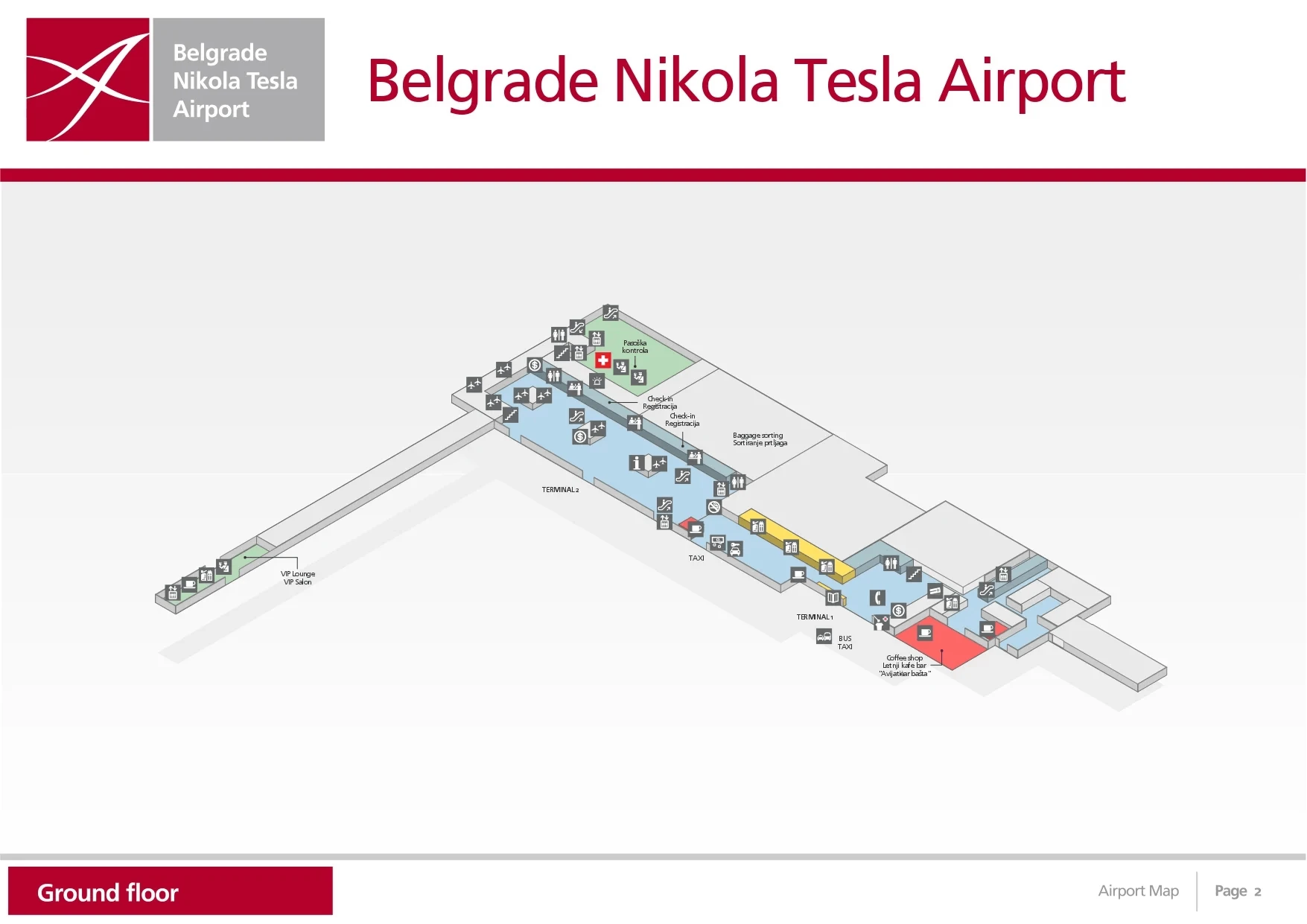
Belgrade Nikola Tesla Airport’s passenger layout is a two-terminal landside front (Terminal 1 and Terminal 2) feeding into a single, expanded “Central Processor” that pushes nearly all departing flows through one long, straight processing sequence. The building is horizontally stretched: check-in islands sit landside, then a walk-through retail “Mall Area,” then centralized security, then departures passport control, before the A- and C-piers fan out airside across the BEG hub grounds.
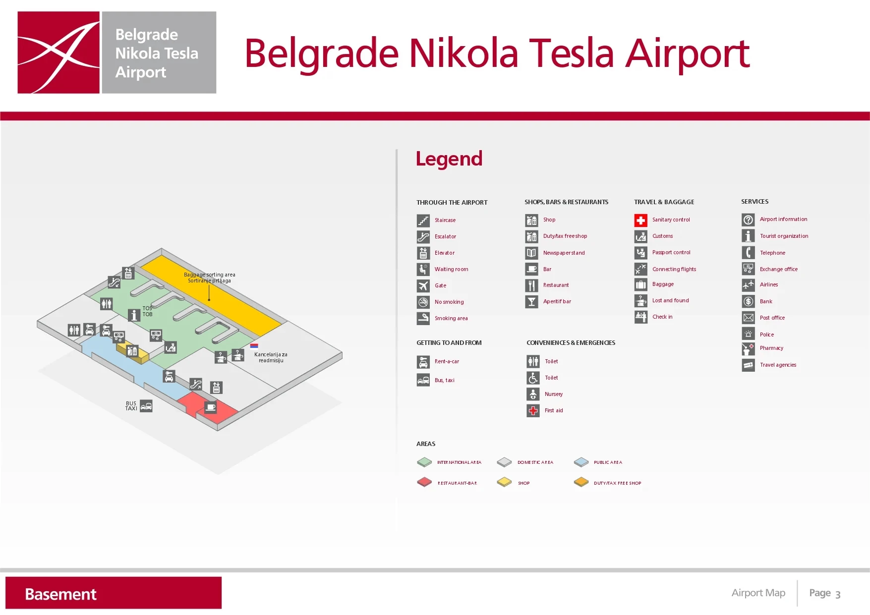
Map Table
| Terminal | Key Airlines | Primary Function | Transfer Mode |
|---|---|---|---|
| Terminal 1 | Wizz Air, charters | LCC landside entry | Landside connector corridor |
| Terminal 2 | Air Serbia, Lufthansa, Turkish, Etihad | Main check-in gravity center | Landside connector corridor |
| Central Processor | All departing passengers | security + exit border control | walk-through retail buffer |
| A- & C-Piers | Mixed | gates + boarding | airside concourse |
Belgrade Nikola Tesla Airport Map Strategy
- Treat passport control as the anxiety trigger: identify where the post-security lanes empty into stanchions, because that’s where the line first spills into circulation and blocks through-traffic.
- Lock your bag drop plan before you walk into the retail buffer: the check-in islands can look “close,” but the Mall Area + centralized processor adds distance and hides the true queue depth until you’re committed.
- Use the Fast Track split only when you can see the physical divergence: priority routing that rejoins too early creates social friction and wasted time if you enter the wrong lane.
- Anchor ground transport on the official curbside flow: route yourself from the arrivals exit to the taxi-voucher process first, then to the legitimate taxi line or the correct bus bay, so you don’t get pulled off-path by solicitors or construction detours.
2026 Belgrade Nikola Tesla Airport Map + Printable PDF
Current 2026 operations run on the Vinci-era Central Processor footprint, with the “Mall Area” buffer and centralized security feeding directly into departures passport control—so the map’s most important value is showing where queues spill back and where priority routing truly diverges. Renovation-era wayfinding still makes pinch-point corridors and connector halls map-verifiable dealbreakers, especially during banked Air Serbia waves.
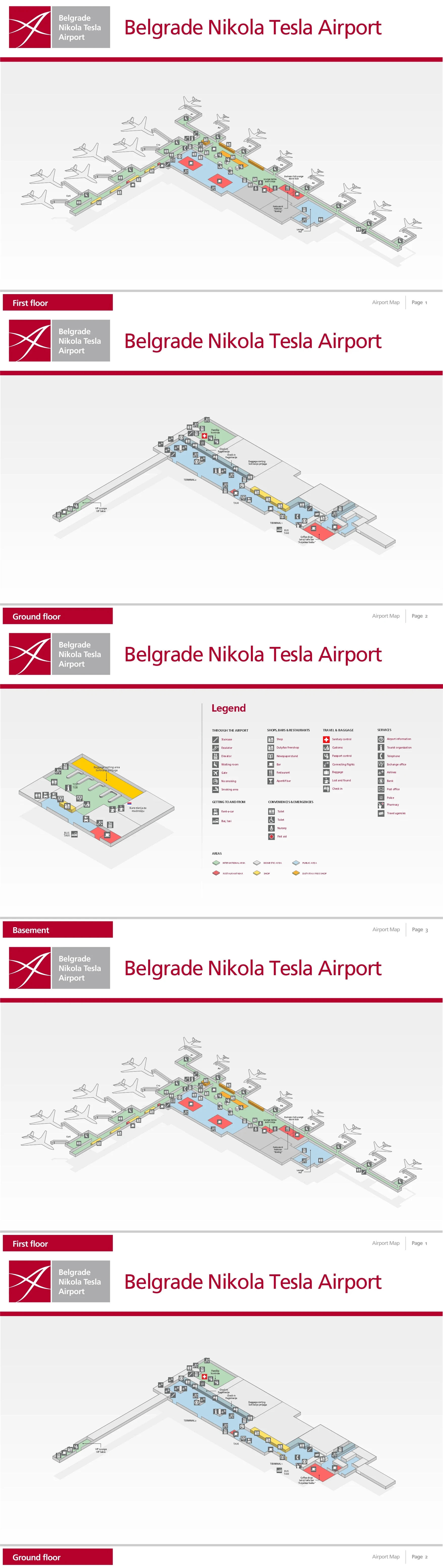
Belgrade Nikola Tesla Airport Terminal 1 First Floor Map 2024-2026
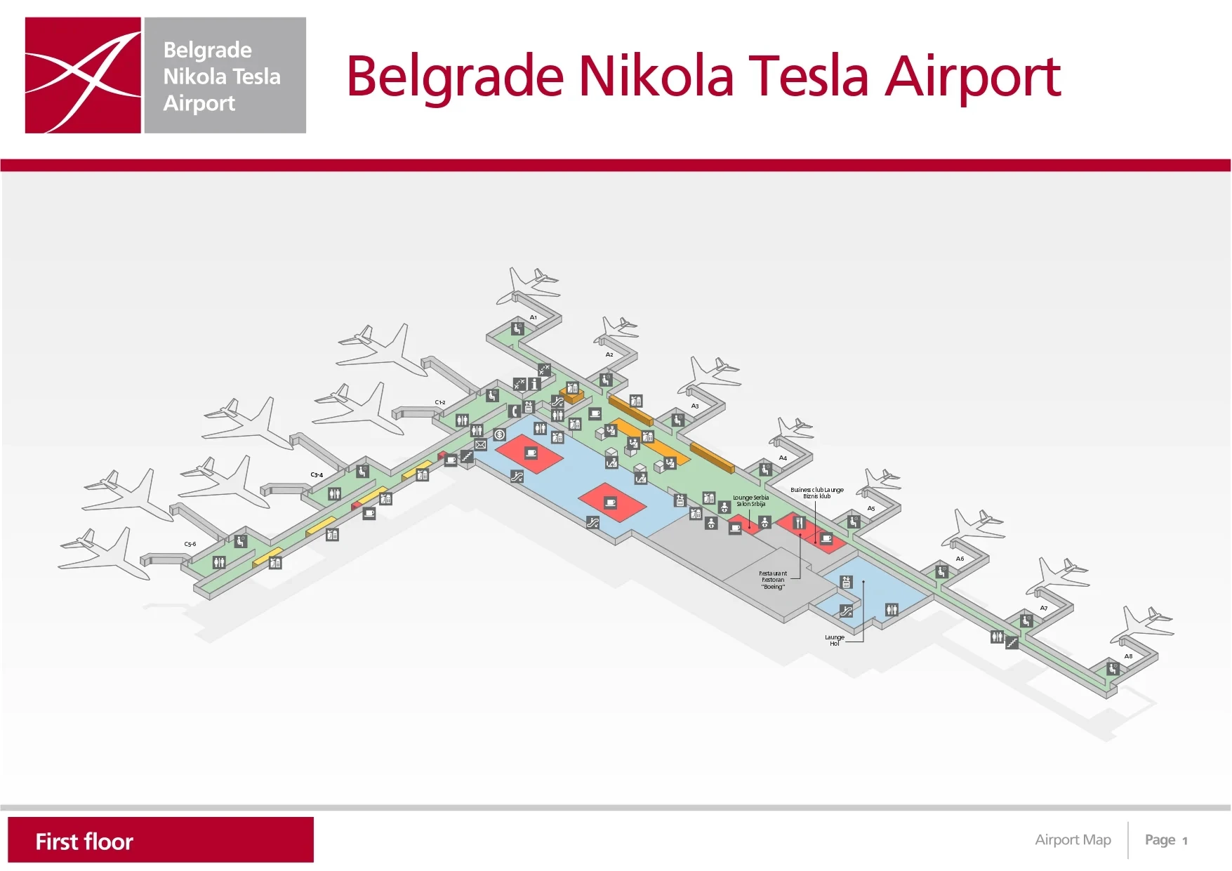
Belgrade Nikola Tesla Airport Terminal 1 Ground Floor Map 2024-2026
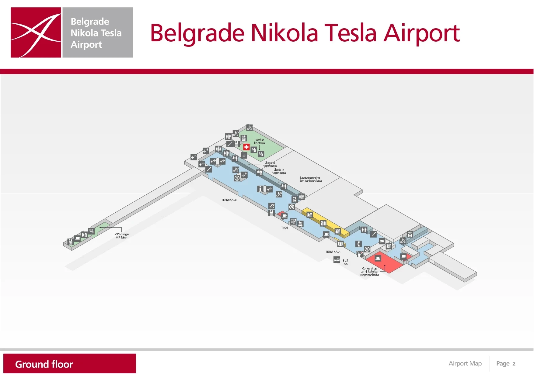
Belgrade Nikola Tesla Airport Terminal 2 Basement Map 2024-2026
Belgrade Nikola Tesla Airport Terminal 2 First Floor Map 2024-2026

Belgrade Nikola Tesla Airport Terminal 2 Ground Floor Map 2024-2026
2026 Belgrade Nikola Tesla Airport Map Guide
Where is the exact physical start-point of the departures passport-control queue (the place it first “spills” into public circulation), relative to the last check-in row?
The departures passport-control queue physically starts immediately after the centralized security exit, where passengers step off the security recomposure area and meet the first belt-barrier stanchions that funnel into the border-control pens. At BEG, that “spill” point is not beside the last check-in row; it’s downstream of the walk-through retail “Mall Area,” after access control and security, so the first public circulation it blocks is the post-security throat, not the check-in hall aisles.
The most reliable landmark logic is to use the security lane outputs as your reference: the queue begins where multiple security lanes merge into a single immigration approach corridor and the first retractable-belt posts appear. If you can still see check-in islands behind you, you’re too early; once you’ve cleared security trays and the space narrows into a controlled pen toward the 16 passport counters, you’re at the queue’s true start.
Where is the Fast Track / Priority lane entrance for departures, and what fixed landmark is directly beside it (signage, doorway, or barrier)?
The Fast Track / Priority lane entrance sits on the lateral edge of the Central Processor access bank, physically separated from the general queue so it can feed into a dedicated priority channel for security and onward to priority handling at passport control. At BEG, the fixed “you’re in the right place” landmark is the Visa / Priority Pass-branded entry point—typically an automated gate/turnstile or controlled opening with card/credential validation—set beside the main belt-barrier corral for the standard lanes.
The way to confirm you’ve found the real entrance (not just a cut-in point) is that it has its own controlled threshold: Visa Platinum/Infinite/Commercial and Priority Pass branding, plus a hard barrier/turnstile or a staffed validation position that prevents crossflow. Stand at that branded entry and you can also get a lateral view of the economy “snake,” which helps you decide whether Fast Track is worth committing to before you step into the main stanchions.
What is the exact walking distance (meters) from the most-used bag drop/check-in zone to the passport-control entry stanchions?
The walking distance is about 150–250 meters from the main Terminal 2 check-in/bag drop islands to the first passport-control entry stanchions. At BEG, that distance expands because you don’t go straight from check-in to border control—you traverse the access-control boundary, the walk-through retail “Mall Area,” and the centralized security zone before you ever reach the passport-control queue.
A practical way to map it is by anchors: start at the densest check-in island cluster in Terminal 2 (the primary departures gravity center), then measure to the access-control e-gates/boarding-pass scan point, continue through the commercial corridor, and end at the point where the post-security lanes merge into the first belt-barrier posts for passport control. The variation (150 vs 250) comes from which end of the check-in islands you begin on and how directly you exit toward the processor throat.
For international-to-international connections, where is the first decision point that determines whether you stay airside vs get routed toward passport control?
The first decision point is the arrivals corridor fork before the immigration hall, where signage splits “Connecting Flights / Transfer” away from “Baggage Claim.” At BEG, that choice determines whether you remain in the secure airside transfer stream or get pulled toward the landside sequence that leads into passport control and arrivals processing.
The key landmark is that this fork happens immediately after you leave the aircraft corridor flow, while you still have uninterrupted forward movement and before you can physically see the passport-control hall. Follow “Connecting Flights / Transfer” to stay in the airside system toward the transfer counters (positioned between waiting rooms near the A1 and C1/C2 area). Follow “Baggage Claim” if you’re terminating or must reclaim bags, which commits you to immigration/passport control and the public arrivals path.
Where is the arrivals passport-control hall exit point that releases passengers into the public arrivals area (the exact doorway/corridor)?
The arrivals passport-control flow releases into the public side at the customs exit doors aligned with the immigration/baggage reclaim outflow, then into the Arrivals Hall at the corridor that lines up with Arrivals Door 2. At BEG, that customs-to-arrivals doorway is the choke point: it’s the physical threshold where the controlled hall ends and “meeters and greeters” compress the public circulation.
Use the baggage reclaim hall as your anchor: after immigration counters, you enter reclaim, then you pass customs (Green Channel) and emerge through the main customs exit doors into the public Arrivals Hall. If you walk straight out from that exit line, the nearest curb egress is Door 2 (or the exit immediately aligned with the customs output), which is also the cleanest reference point for continuing to official taxi and bus pickup without drifting into side doors that put you farther from the regulated curbside flow.
Where is the official “legitimate taxi” process anchored (voucher/booth/dispatcher), and what is the exact route from arrivals exit to that point?
The legitimate taxi process is anchored on the airport’s fixed-price Taxi Voucher system, printed from the official e-kiosks and then honored by the regulated taxi line at the curb by Arrivals Door 2. At BEG, the lowest-friction anchor is the voucher kiosk inside Baggage Claim, because it keeps you out of the public-hall solicitation zone.
| Route step | Fixed landmark anchor | What you do |
|---|---|---|
| 1 | Baggage Claim hall | Use one of the 3 taxi voucher e-kiosks while waiting for bags |
| 2 | Customs “Green Channel” exit doors | Exit baggage reclaim into the public Arrivals Hall |
| 3 | Arrivals Door 2 alignment | Walk straight to Door 2 (the curb-facing egress aligned with customs outflow) |
| 4 | Official taxi line / taxi info point | Present the voucher to the dispatcher/first official driver in the queue |
If you missed the baggage-claim kiosks, the backup anchor is the single e-kiosk in the public Arrivals Hall post-customs—still official, but more crowded and more exposed to tout pressure—so the map-safe rule is “voucher first, curb second,” not the other way around.
Where is the primary airport bus stop (or shuttle stop) pickup point relative to the arrivals exit doors (left/right, which crossing, which curb zone)?
The primary bus/shuttle pickup is on the Arrivals curb immediately outside the public hall, with the A1 minibus stop typically positioned to the left of the official taxi rank when you face the roadway from the arrivals exit. At BEG, the most dependable curb anchor is Arrivals Door 2, because it aligns with the main customs outflow and the regulated taxi process—then you orient left/right from that door.
Because BEG’s loop-road operations can shift public buses between levels, use a two-anchor rule: first, step out at Door 2 and identify the taxi line; second, look left along the same curb for the marked public transport bay (standard blue bus signage and posted line info) where A1 commonly loads. For lines like 72/600 that sometimes operate from the Departures level (upper curb) during congestion or construction phases, the tell is the absence of the posted bay at Arrivals—if the Arrivals curb is jammed or signage directs “Departures,” take the nearest escalator/lift up and re-check the transport totem at the upper curb near the Terminal 1/2 connector area.
Where is the closest elevator/lift route that bypasses stairs between departures processing (check-in level) and the departures control zone (passport/security level)?
The closest lift route is the central elevator core embedded in the mid-hall service block commonly described as the “toilet island” in the middle of the expanded check-in area. At BEG, that core provides a direct vertical move that avoids the terminal-end escalators, letting you reposition between the lower landside level and the departures processing floor without getting trapped in the busiest edge corridors.
Use the check-in hall geometry as your anchor: from the main Terminal 2 check-in islands, aim toward the central service block (restrooms clustered in the middle of the hall) rather than walking to the far left/right ends where the obvious escalator banks are. The elevator doors are within/adjacent to that service block; once inside, ride to the level that aligns with departures processing and then re-enter the flow toward the Central Processor entrance rather than rejoining the congested end-cap circulation.
Where is the “queue-length vantage point” (the first spot you can visually judge how bad passport control is) without committing into the line?
The first reliable queue-length vantage point is the approach corridor coming out of the “Mall Area” toward the Central Processor, where you can see the security-to-passport-control throat before stepping into the stanchions. At BEG, that’s the earliest spot you can judge whether the passport-control line is spilling back and how many border-control booths are actively staffed, without physically committing into the snake.
A secondary vantage point is the Fast Track side entrance: standing beside the Visa/Priority Pass-branded entry gives you a lateral sightline along the economy queue’s belt barriers, letting you estimate whether the line is contained within the pens or pushing into the open circulation behind the security outputs. If you can still freely pivot and walk away, you’re at a true vantage point; once you pass the first belt posts and your path becomes one-directional, you’ve already committed.
Where is the narrowest corridor pinch-point on the departures flow (the spot most likely to compress into a single-file queue), as shown on the terminal layout?
The narrowest pinch-point is the Terminal 1–Terminal 2 connector corridor, where bidirectional foot traffic compresses into a constrained hallway linking the legacy T1 landside area to the Terminal 2 hub. At BEG, that connector becomes the single-file risk zone when charter/LCC pulses and mainline departure waves overlap, because it carries both cross-terminal walkers and people repositioning toward the Central Processor.
A secondary compression spot that behaves like a departures pinch-point during peaks is the constrained throat where the Central Processor outputs converge—especially where crowds pause to recompose after security and then funnel toward passport control. Use fixed anchors to avoid getting trapped: if you must traverse between T1 and T2, do it early (before queues bank), and if you’re heading for processing, don’t stop in the narrow merge zone between security outputs and the first immigration stanchions—step fully into a wide holding area or commit cleanly to the correct lane.
Archive Belgrade Nikola Tesla Airport Map
Below are all historical map versions for Belgrade Nikola Tesla Airport. Each year includes the official map available for that period, presented as both WebP and PDF.
2024-2026 Belgrade Nikola Tesla Airport Map (Official 2024 Edition)


