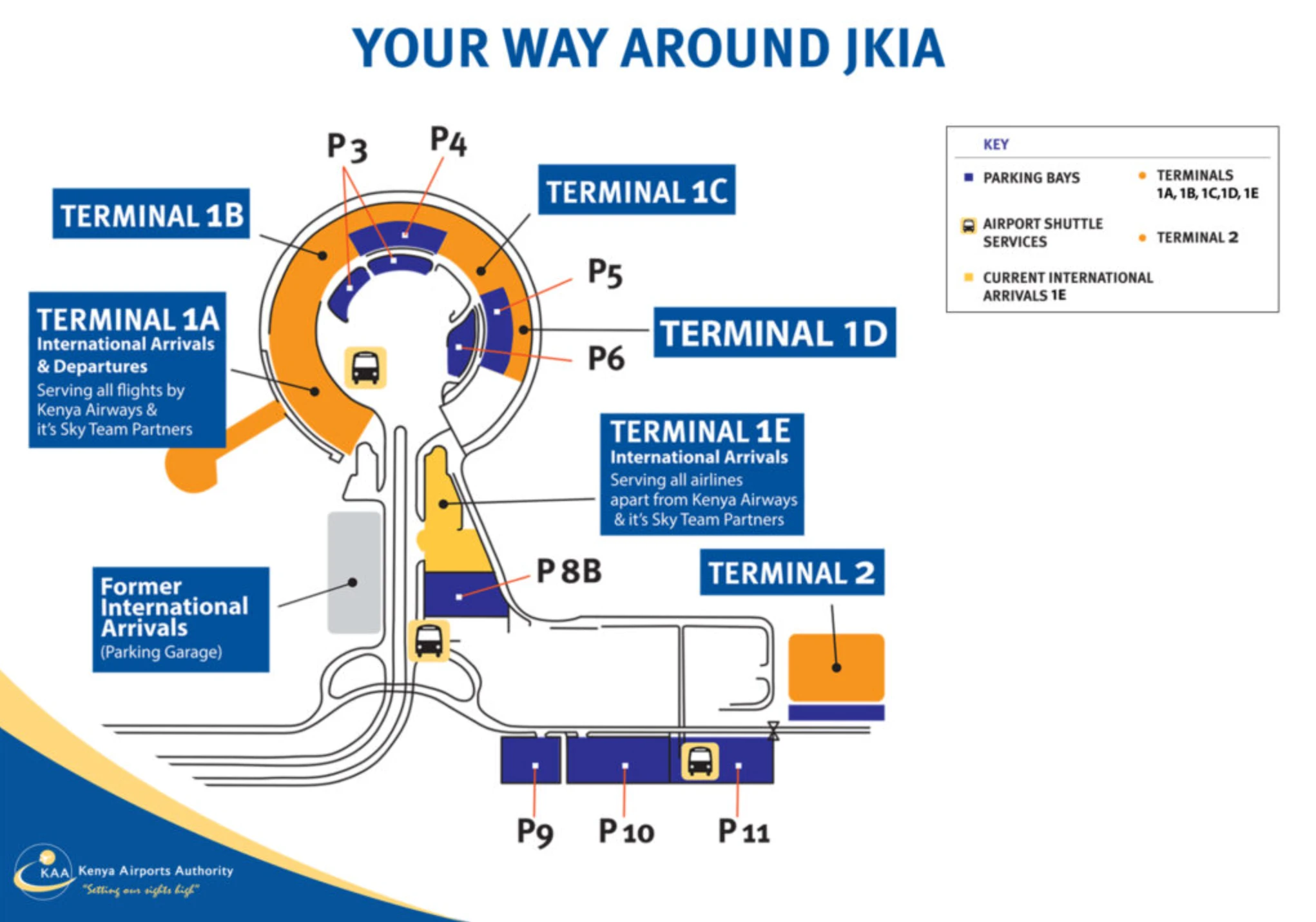
Jomo Kenyatta International Airport Terminal 1 Map (Most Up-To-Date)
JKIA Terminal 1 is a semi-circular, multi-unit complex (1A–1D) arranged along a one-way frontage road, with Terminal 1E handling international arrivals separately. The practical scale is “short by car, long on foot”: curb-to-door is close, but landside walks between units can stretch several hundred meters. Within Nairobi’s primary airport complex, movement is oriented from Airport South Road’s perimeter checkpoint into the terminal loop, then inward through layered screening rings toward gate clusters.
Map Table
| Zone | Connection | Walk Time |
|---|---|---|
| Perimeter ring | Airport South Road vehicle screening yard | drive-only |
| Curbside loop | 1A → 1B → 1C → 1D frontage | short stop |
| Landside concourse | 1A ↔ 1B/1C pedestrian corridor | 10–20 min |
| Airside | duty-free hub → gate clusters (12–24) | 6–10 min |
Jomo Kenyatta International Airport Terminal 1 Map Strategy
- Time volatility starts at the vehicle-entry screening yard on Airport South Road; treat it as a hard node, then measure everything else from fixed door sets at Terminals 1A/1B/1C.
- Curb stress drops when you navigate by door sets, not terminal names: identify the exact Terminal 1A/1B/1C entry doors that feed the terminal-entry screening doorway, then keep the curb-to-door distance to ~50–100 meters.
- Inside, follow a deterministic chain of map-verifiable checkpoints: terminal-entry screening doorway → check-in hall → emigration hall → primary security bank → duty-free hub → gate clusters with secondary screening (notably the Gate 19 model).
- Reduce “where do I go now?” arrivals confusion by pre-committing to the exit sequence: baggage claim exits → exit screening/baggage scan pinch point → glass doors to the public concourse → official taxi curb vs. Car Park 1 for app-based rides; avoid non-permitted pick-up curb zones and assume step-free access is not universal across all paths.
2026 Jomo Kenyatta International Airport Terminal 1 Map + Printable PDF
Current operations at 2026 still run on stacked screening layers: vehicle-entry checks before the terminal loop, terminal-entry screening at the façade doors, and secondary “at-the-gate” screening for select departures. Expect curb dwell enforcement (fast drop-offs) and arrivals-side exit bottlenecks at Terminal 1E, where final baggage scanning can compress foot traffic near the exit doors.
2026 Jomo Kenyatta International Airport Terminal 1 Map Guide
What is the exact physical location of the vehicle-entry passenger screening checkpoint on the approach to JKIA Terminal 1 (pinpointable node on the airport road layout)?
The vehicle-entry passenger screening checkpoint is on Airport South Road at the airport’s main interdiction yard, before the terminal loop, opposite the Kenya Civil Aviation Authority (KCAA) Headquarters and near Barabara Plaza. This checkpoint is the hard “point of no return” for vehicles entering the JKIA internal road network.
Airport South Road feeds traffic off the Mombasa Road/A104 corridor into the airport complex, and the screening yard sits roughly 1,000 meters from the Terminal 1 curb frontage (the security standoff distance). Use the KCAA HQ frontage as the visual anchor: once you’re queued there, you’re in the correct lane set for airport entry and committed to the terminal sequence ahead (1A → 1B → 1C → 1D).
What is the walking distance (meters) from the Terminal 1 drop-off point to the first terminal-entry screening doorway used for international departures?
The walking distance is approximately 50–100 meters from the Terminal 1 departures drop-off frontage to the first terminal-entry screening doorway for international departures. This is the curb-to-door span under the departures canopy directly opposite the Terminal 1A/1B/1C façade doors.
The shortest path is a straight curb-to-glass walk: stop at the central departures drop-off frontage (the continuous curb serving 1A–1D), then walk perpendicular across the covered sidewalk to the nearest active departures door set feeding the x-ray/metal-detector station immediately inside the glass façade. The distance range widens depending on where your driver is allowed to pause within the monitored 3–5 minute curb window and which door set (1A vs 1B/1C) is open and staffed at that moment.
Where is the terminal-entry screening zone physically positioned relative to Terminal 1A / 1B / 1C entrances (which doors feed it)?
The terminal-entry screening zone is positioned immediately inside the glass façade at the Terminal 1A, 1B, and 1C departures door sets, acting as the first “building shell” checkpoint before any check-in counters. Each terminal unit feeds its own near-door x-ray/metal-detector lane(s), rather than a single centralized landside screening hall.
Terminal 1A uses distinct entrance door sets (often split by cabin/class), and each door set has a screening station directly behind it. Terminal 1B and Terminal 1C rely on common-use departures entrances where the screening lanes sit just inside the older check-in hall frontage, so the queue can spill outward onto the covered curbside sidewalk. If you are standing outside the doors and can see the conveyor belts through the glass, you are at the correct terminal-entry screening node for that unit.
What is the shortest indoor route from Terminal 1 check-in counters to the primary security screening (the first major x-ray/metal detector bank)?
The shortest indoor route is a straight, linear progression from the check-in hall toward the emigration/passport control hall and then into the main security bank immediately after passport control (most clearly structured in Terminal 1A). This is the first large, centralized x-ray/metal-detector interface that feeds the duty-free hub and the main gate corridors.
From the check-in counters, move forward into the central processing corridor rather than side aisles, using the emigration hall as the next fixed landmark. After exiting emigration, continue straight into the primary security bank positioned as the next choke point before the duty-free area; in Terminal 1A this bank is designed to feed Gates 12–24 and sits on the direct axis between the check-in hall and the post-security commercial zone. In Terminal 1B/1C, the same logic applies but with tighter circulation: stay on the main interior corridor that leads from counters to immigration, then to the first major consolidated screening bank ahead.
Where is the passport control / emigration hall located relative to the main security exit (left/right/straight and which corridor)?
The emigration/passport control hall is positioned immediately before the main security bank on the primary forward corridor from the check-in hall, so you reach it first and then continue straight into security. In Terminal 1A, the flow is designed as a single axis: check-in hall → emigration (straight ahead) → primary security immediately after you clear passport control.
After you complete passport control and exit the emigration counters, do not peel into side corridors; the next major funnel straight ahead is the primary x-ray/metal detector bank feeding the duty-free hub. If you find yourself turning left or right into retail or seating before seeing the main security lanes, you’ve likely drifted off the core corridor and need to re-orient toward the central forward path connecting immigration to the security exit.
Which gates or gate clusters in Terminal 1 have a secondary “at-the-gate” screening checkpoint (map-identifiable gates only)?
Gate 19 in Terminal 1A is the clearest map-identifiable secondary “at-the-gate” screening checkpoint, built for Last Point of Departure-style screening on select long-haul routes. Gates 14–24 in the Terminal 1A west-wing cluster also commonly operate with screening positioned at the entry to the individual gate lounge/holding area rather than relying only on the main security bank.
| Gate / Cluster | Terminal Unit | Secondary Screening Pattern |
|---|---|---|
| Gate 19 | 1A | dedicated gate-entry secondary checkpoint |
| Gates 14–24 | 1A | checkpoint at lounge/holding-area entry |
| Gates 9–12 | 1B | decentralized gate/zone entry checkpoint |
| Gates 4–8 | 1C | decentralized gate/zone entry checkpoint |
What is the walking distance (meters) from emigration/passport control to the farthest Terminal 1 gate cluster commonly used for international departures?
The walking distance is approximately 350 meters from emigration/passport control to the farthest commonly used international gate point in Terminal 1A, which is the west-wing end near Gate 24. This is the longest “standard” airside leg after you clear the main processing nodes.
From the emigration exit, continue straight into the primary security bank, then emerge into the duty-free hub, which is the key triangulation landmark for the gate corridors. From the duty-free hub, take the west/left-bound corridor serving Gates 14–24 and continue to the far end of the wing; moving walkways may reduce effort but reliability varies, so the map distance is the safer planning reference. If your boarding pass indicates a gate in the 14–24 range, assume the farthest-case walk is to the Gate 24 end.
Where is the arrivals-side “exit screening / baggage scan” point located relative to Terminal 1 baggage claim hall exits (which exit funnels into it)?
The arrivals-side exit screening / baggage scan point is positioned immediately before the public exit doors at the end of the Terminal 1E customs/baggage hall, so the baggage-claim outflow funnels directly into 1–2 x-ray lanes before you can reach the arrivals greeting area. This checkpoint sits inside the hall, not outside on the curb.
After collecting bags in the Terminal 1E baggage claim area, follow the main stream toward the glass sliding exit doors; the x-ray belts and inspection tables appear as the final choke point directly in front of those doors. The exit funnel is the primary straight-ahead customs hall outflow—if you can see daylight and the doors to the public concourse, you’re within a few meters of the exit screening lanes and should expect the queue to compress there before the terminal release point.
What is the shortest route from Terminal 1 baggage claim to the official taxi/rideshare pickup area (single path, map-verifiable)?
The shortest route is straight out of the Terminal 1E arrivals exit doors to the curbside taxi line, while app-based rideshare pickup requires crossing to Car Park 1. These are two distinct, map-verifiable pickup nodes separated by the access road immediately outside the arrivals doors.
From baggage claim, follow the main flow to the exit screening x-ray point, then continue to the glass sliding doors labeled as the Terminal 1E exit into the arrivals greeting area. For official taxis, turn directly to the curb immediately outside those doors where the yellow/authorized taxi queue forms. For rideshare (Uber/Bolt), walk forward to the marked pedestrian crosswalk, cross the pickup lane to the multi-story parking structure (Car Park 1), then enter at ground level to the designated app-based taxi zone (the total door-to-parking distance is about 80 meters).
Which Terminal 1 doors/curb zones are designated for pick-up vs drop-off (exact curb segments as shown on terminal maps/diagrams)?
The designated drop-off curb is the departures frontage opposite Terminals 1A, 1B, 1C, and 1D (the continuous departures curb), while the designated international arrivals pick-up curb is opposite Terminal 1E. These two curb segments are functionally separated to prevent mixing arrivals and departures flow.
| Curb Segment | Function | Terminal Frontage |
|---|---|---|
| Point 1 departures frontage | drop-off | 1A / 1B / 1C / 1D |
| Point 2 arrivals frontage | pick-up | 1E |
| Car Park 1 ground level | app-based rideshare pick-up | opposite 1E across access road |
What is the walking distance (meters) between Terminal 1A and Terminal 1C via the shortest landside pedestrian path?
The walking distance is approximately 400–500 meters between Terminal 1A and Terminal 1C via the shortest landside pedestrian path. This is the cumulative span along the semi-circular landside concourse linking the terminal units under the covered sidewalk/canopy sections.
The shortest path is the direct landside corridor/walkway that follows the terminal frontage rather than detouring through interior check-in areas: start at the Terminal 1A landside exits, stay on the covered sidewalk that runs parallel to the one-way terminal loop road, pass Terminal 1B, and continue to Terminal 1C. Because the canopy is open-sided, the route is walkable with luggage but can be exposed to wind and rain; use the terminal façade as your continuous landmark so you don’t drift into the roadway edge.
Where are the working elevators / step-free paths that connect Terminal 1 departures level to gate level corridors (map-identifiable vertical circulation points)?
The most map-identifiable step-free vertical circulation points are in Terminal 1A, where elevators connect the Departures Level (Level 1) to the lounge/mezzanine level (Level 2) near the Simba and Pride lounges. Gate corridors in Terminal 1A are largely level or ramp/jet-bridge connected, reducing reliance on vertical movement for most boarding paths.
Terminal 1A’s accessibility failure mode is not inside the departures core but on arrivals processes that use remote stands at Terminal 1E, where stairs-to-bus transfers are common and step-free continuity depends on pre-booked assistance. For step-free routing in Terminal 1A, triangulate on the lounge landmark: if you are near the Simba/Pride lounge zone, you are within the elevator-served vertical core that links levels without stairs. For Terminal 1B/1C, expect fewer clearly signed elevator nodes and plan to remain on the most direct level corridors once you clear processing.
What is the exact location of the largest security screening bank in Terminal 1 (the one with the most lanes), relative to major landmarks (check-in hall, central corridor)?
The largest security screening bank is in Terminal 1A and sits immediately after the emigration/passport control hall on the main forward corridor, feeding directly into the duty-free hub and onward to Gates 12–24. This is the highest-capacity x-ray/metal-detector node in the Terminal 1 departures system.
From the Terminal 1A check-in hall, keep to the central corridor that leads straight to emigration; once you clear passport control, the next major open area filled with multiple parallel screening lanes is the primary security bank. Its landmark triangulation is “passport control exit behind you, duty-free entry ahead of you”: if you can see the duty-free zone beyond the lanes, you are at the correct largest-bank node rather than a smaller localized checkpoint near a side lounge or gate holding pen.
Where is the nearest restroom to the gate-area secondary screening point(s) (single nearest facility, map-verifiable)?
The nearest restroom to the secondary screening zone for the Terminal 1A west-wing gate cluster is on the basement level between Gates 22 and 24. This is the closest map-identifiable facility to the Gates 14–24 holding-area/security setup near the far end of the wing.
From the Gates 14–24 corridor, continue toward the far west end (using the Gate 22–24 end as your anchor), then look for access down to the basement level near that end-of-wing node. This location is non-intuitive because it is not on the main gate level corridor, so leaving a screened holding area late can force a backtrack and possible re-screening on re-entry; if you are approaching secondary screening at a west-wing gate, use the Gate 22–24 end landmark to find the restroom before you enter the holding pen.
Archive Jomo Kenyatta International Airport Terminal 1 Map
Below are all historical map versions for Jomo Kenyatta International Airport. Each year includes the official map available for that period, presented as both WebP and PDF.
2024-2026 Jomo Kenyatta International Airport Terminal 1 Map (Official 2024 Edition)