Adolfo Suárez Madrid–Barajas Airport Map (Most Up-To-Date)
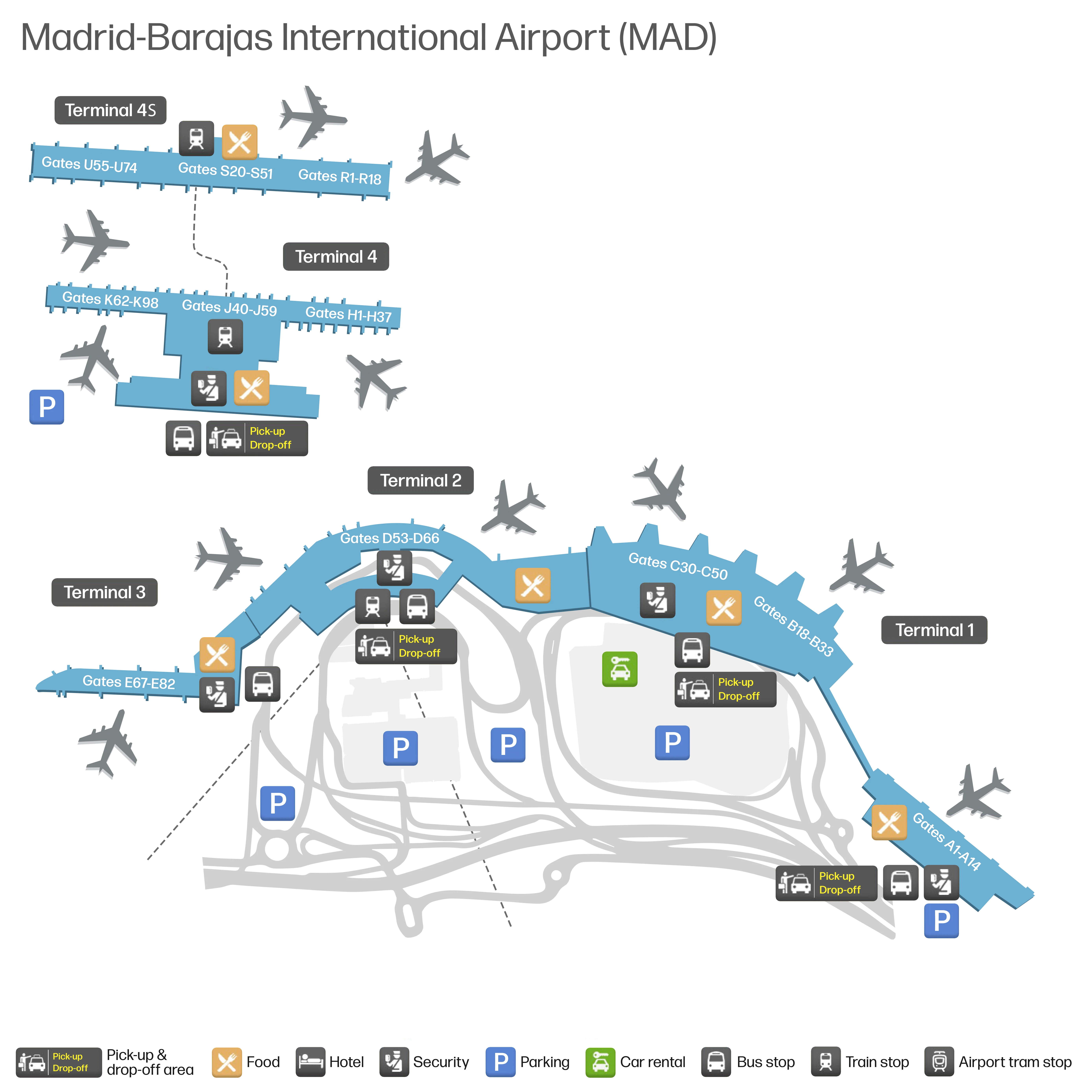
Madrid–Barajas is a physically split, two-complex airport: the Legacy terminals (T1–T2–T3) clustered together and the T4/T4S complex separated by runway infrastructure, with Terminal 4 laid out as a long linear “canyon.” Within Madrid’s primary aviation hub, the dominant navigation risk is vertical change (multiple level drops/rises) layered on top of long corridors, plus chokepoints at security and passport control.
Map Table
| Terminal | Key Airlines | Primary Function | Transfer Mode |
|---|---|---|---|
| T1 | SkyTeam, mixed international | Non-Schengen arrivals, mixed gates | landside shuttle bus, landside walk |
| T2 / T3 | Star Alliance, mixed European | Schengen departures, check-in dispersion | landside walk, internal corridors |
| T4 | Iberia, oneworld | Schengen / domestic hub processing | APM to T4S, landside shuttle bus |
| T4S | Iberia long-haul, oneworld long-haul | Non-Schengen long-haul gates (S) | APM only, passport control barrier |
Adolfo Suárez Madrid–Barajas Airport Map Strategy
- Treat Terminal 4 Satellite as an island: boarding pass, documents, and checked-bag status finalized before committing to the APM descent to Level -2.
- Override instinct at Terminal 1: the free shuttle to Terminal 4 is on the Departures level (Level 1), not the Arrivals curb (Level 0).
- Budget for “vertical penalty” at Terminal 4: central security exit to the APM is a long corridor plus a multi-level drop; elevators beat multi-flight escalators under time pressure.
- Assume passport control can spike at Terminal 4 Satellite: plan to use urgent-connection lanes when available and avoid arriving at the gate at “boarding time” for high-screening routes.
2026 Adolfo Suárez Madrid–Barajas Airport Map + Printable PDF
The 2026 layout still functions as a bifurcated airport: T1–T2–T3 operate as one contiguous legacy block while Terminal 4 and the Terminal 4 Satellite behave like a separate island. Printing a 2026 map is most useful for spotting level changes to the T4↔T4S APM, locating the T1 departures-level shuttle stop, and pre-identifying passport control choke points.
2026 Adolfo Suárez Madrid–Barajas Airport Map Guide
Where is the exact access point in Terminal 4 to reach the underground people-mover/train to Terminal 4 Satellite (the specific corridor + level change point)?
The access point is the central “Gates M / Gates S” descent core immediately after Terminal 4’s central security exit, reached by walking into the main airside retail plaza and targeting the central elevator bank near the pillar-color transition zone.
From the central security exit (Terminal 4, Departures processing), continue straight into the main airside concourse until you reach the terminal’s central node (the busiest retail/duty-free plaza). Follow overhead signs for “Gates M” and “Gates S” to a high-capacity elevator bank paired with a cascade of escalators; this is the committed level-change point. Descend to Level -2 for the APM platform to Terminal 4 Satellite—there is no same-level corridor to the train, and escalators require multiple separate flights, which slows luggage-heavy connections.
What is the exact walking distance from Terminal 4 central security exit to the people-mover/train platform entrance for Terminal 4 Satellite?
The walking distance is approximately 350 meters from Terminal 4’s central security exit to the elevator-bank access point for the Level -2 people-mover platform.
That distance is the horizontal corridor from the central security outflow into the main retail plaza and onward to the terminal’s central descent core (signed for “Gates M” and “Gates S”). The time swing comes from the vertical drop, not the corridor length: the route requires descending multiple operational levels to reach Level -2, so fast-walk plus express elevators typically lands at the platform in about 6–8 minutes, while using escalators across multiple flights more often runs 12–15 minutes, especially with carry-ons and crowding at the level-change core.
In Terminal 4 Satellite, where is departure passport control located relative to the train exit (exact level and path split)?
Departure passport control is on Level -1 directly above the train platform exit, forming a full-width barrier you must pass immediately after ascending from the Level -2 people-mover arrival.
After the train arrives at Terminal 4 Satellite (Level -2), follow the central escalators/elevators up one level to Level -1 (often shown as a mezzanine/transfer level on older diagrams). Passport control spans the circulation core on this level, so the flow is forced into the queue with no bypass. Once cleared, the route splits into a final ascent to Level 1 (Departures) for the S-gates and the main duty-free/retail spine; the decision point is only after immigration, when the passenger stream is released into the departures-level concourse.
Where is the free inter-terminal shuttle bus stop in Terminal 1 (exact level + door/zone where passengers queue for Terminal 4)?
The shuttle-bus stop is on Terminal 1’s Departures level (Level 1) outside on the curb, not on the Arrivals level where most passengers instinctively look.
From Terminal 1 Arrivals (Level 0), go to the nearest elevator/ramp bank up to Level 1, then exit to the Departures curbside and follow the exterior frontage to the marked “Bus Tránsito / Transit Bus T1–T2–T3–T4” stanchion. The queue forms along the curb near the central frontage of Terminal 1 (commonly referenced near Departures doors 1–2 when facing the roadway). The negative constraint that prevents false shortcuts: no free shuttle pickup operates at the Terminal 1 Arrivals curb, so searching at street level produces a predictable 10–15 minute failure.
Where is the Terminal 4 drop-off point for the Terminal 1↔Terminal 4 free shuttle bus (exact curb/door/zone)?
The drop-off is at Terminal 4 on the Departures curb (Level 2), placing you on the correct level for check-in and security without needing to change floors.
After the shuttle arrives, you step off onto the upper-deck frontage of Terminal 4 and enter through the nearest Departures entrance doors directly into the check-in hall. The practical landmark is the main Departures curbside line in front of the Terminal 4 check-in area (the same curb used for passenger drop-offs), so you should orient immediately toward the terminal’s central security zone once inside rather than drifting toward Arrivals or the transport levels.
What is the exact walking distance from the Terminal 4 shuttle-bus drop-off to the closest departures security entrance in Terminal 4?
The walking distance is approximately 80 to 120 meters from the Terminal 4 Departures curb shuttle drop-off to the nearest security entrance.
From the drop-off point on Level 2, walk across the sidewalk into the nearest Departures doors, then continue straight into the check-in hall toward the central security area (the security banks sit centrally and toward the lateral wings). The route is short and direct—typically 2 to 3 minutes—so the time risk in a Terminal 1↔Terminal 4 transfer is almost never this segment; it’s the Terminal 1 level change to Departures and the shuttle wait/ride that introduce the real variance.
What is the maximum on-map walking time from Terminal 4 Satellite passport control to the farthest S-gate used for long-haul departures?
Walking takes up to about 10–15 minutes from Terminal 4 Satellite passport control to the farthest S-gates at the ends of the satellite.
After clearing passport control on Level -1, you ascend into the Level 1 departures core that opens into the central duty-free/retail spine (the geometric “center” of the satellite). From that retail core, the farthest long-haul gates are at the extreme ends of the S-piers (commonly the highest-numbered gates on one wing, such as S40–S50). The on-map distance from the central core to the tip of a wing is roughly 500–600 meters; moving walkways exist but can be congested or out of service, so the reliable plan is a full 15-minute walk if your gate is at the end.
For a Schengen arrival in Terminal 4 connecting to a non-Schengen departure in Terminal 4 Satellite, where is the exact location of any mandatory re-screening checkpoint on the route to Gates S?
No central re-screening checkpoint exists on the main Terminal 4 to Terminal 4 Satellite route for a typical Schengen-to-non-Schengen connection; the only mandatory choke on the path is passport control at Terminal 4 Satellite Level -1.
The route stays within the secure system: from Terminal 4 airside, descend to the Level -2 APM, ride to Terminal 4 Satellite, then ascend to passport control on Level -1 before reaching the Level 1 S-gates concourse. The exception that creates the “gate trap” is destination-specific secondary screening placed at the individual gate holding area—most commonly on flights to the United States, Israel, and occasionally the United Kingdom—where document checks and bag/electronics inspection happen at the entrance to that gate pen (for example, at an S-gate in the far wing). That screening adds roughly 15–20 minutes to boarding even if you’re physically at the gate.
Where is the “Green Jackets” information desk in the Terminal 1 baggage claim hall used to request an internal shuttle/assisted transfer to Terminal 4 Satellite (exact position within the hall)?
The “Green Jackets” desk is inside Terminal 1’s baggage reclaim area on Level 0, positioned within Baggage Reclaim Hall 1 before the “Nothing to Declare” customs exit.
Look for Aena staff in bright green jackets/vests at the staffed information point in the reclaim hall footprint (the service desk you can reach while still among the carousels and reclaim circulation). The dealbreaker is the customs threshold: once you pass through the “Nothing to Declare” doors into the public Arrivals hall, you are landside and you’ve forfeited eligibility to request the internal airside transfer bus. If you need the assisted/airside option, stop at the desk first with boarding pass and baggage tags ready.
What is the exact walking route distance from Terminal 4 baggage claim exit to the Cercanías/Renfe station entrance (first access point to the station)?
Walking is about 150–200 meters from the Terminal 4 baggage claim exit to the first Cercanías/Renfe station access point.
Exit baggage reclaim into the Terminal 4 Arrivals hall (Level 0) and head to the central atrium where the main elevator/travelator banks drop to the transport hub. Descend to Level -2 and follow signs to Cercanías (red “C” logo) for the station entrance/turnstiles; the Renfe Cercanías and Metro Line 8 areas share Level -2 but are adjacent and easy to confuse under stress. The distance typically breaks into ~100 meters from reclaim exit to the main vertical-core elevators, then ~50 meters from the Level -2 exit to the Cercanías entry.
What is the exact walking distance from the Terminal 1 arrivals/baggage reclaim exit to the Terminal 1↔Terminal 4 shuttle-bus queue point (so a checked-bag self-transfer can be timed)?
Walking distance is approximately 250–300 meters from the Terminal 1 arrivals/baggage reclaim exit to the free shuttle-bus queue on the Departures curb.
| Route segment | Anchor point | Distance |
|---|---|---|
| Exit baggage reclaim → Arrivals hall traverse | baggage reclaim exit doors into Level 0 Arrivals hall | 50–100 m |
| Arrivals hall → vertical core | elevator/ramp bank up to Departures | 50–100 m |
| Departures level exit → curb | Level 1 doors to Departures curb | ~50 m |
| Curb walk → bus queue | “Bus Tránsito / Transit Bus T1–T2–T3–T4” stanchion | 50–100 m |
With checked bags, plan 10–12 minutes because elevator waits and crowded lifts create the main variance.